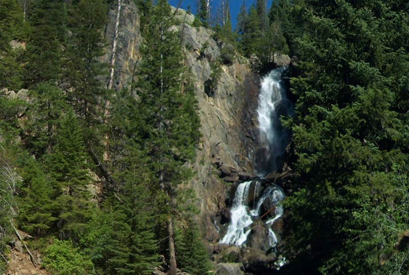
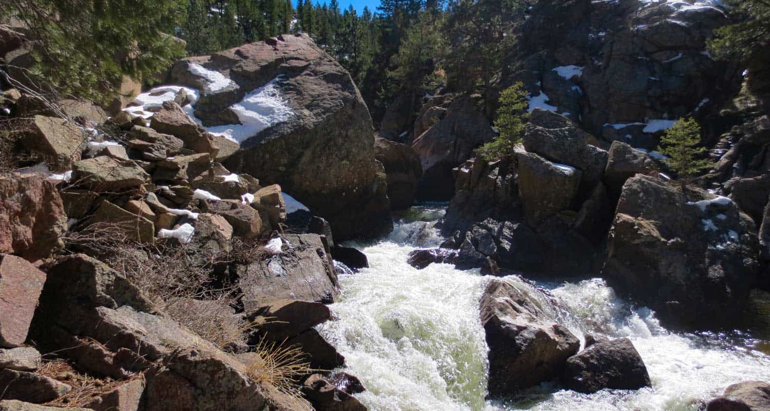
Fish Creek Falls Near Steamboat Colorado
A 284 foot waterfall! Need we say more. Fish Creek Falls is a 1/4 mile hike located just outside Steamboat Springs, Colorado--about 3.5 hours from Denver. The Fish Creek Falls Overlook trail is handicap accessible, and a second trail takes hikers down to the base of the falls. Explore the full Fish Creek Falls hike profile below for trail map, driving directions, and many the details you need to enjoy this adventure near Steamboat, Colorado.
Trail Snapshot: Fish Creek Falls in Steamboat Springs
| Hike Distance | 1/2 mile Round Trip (both options) |
|---|---|
| Difficulty | Easy |
| Duration | Approx 30 min Round Trip |
| Trail Type | Out and Back |
| Starting Elevation | 7500′ |
| Elevation Gain | negligible |
| Seasons | Year Round |
| Dogs | Allowed On Leash |
| Denver Drive Time | 3 hrs |
| Driving Directions to Fish Creek Falls, Steamboat Springs | Click for Google Map |
| Town Nearest Hike | Steamboat Springs, Colorado |
| Beauty | Waterfalls, Creek |
| Activities | Hiking, great picnic facilities, ice climbing, photography |
| Hours | 6AM to 10AM |
| Fee | $5 Day Use Fee - Cash or Check |
Parking & Trailhead Information for Fish Creek Falls
The trailhead for the waterfall is about three miles outside of the town of Steamboat Springs, Colorado. Stop at the pay station to purchase the day use fee. There are two parking areas: one will be on your left driving in, and the larger lot--which is closer to the trailhead--at the end of the road.
The Hike: Fish Creek Falls
Fish Creek Falls is one of the most accessible waterfalls in Colorado, perfect for families with small children who are not yet able to hike longer distances. It's also wheelchair accessible via the Falls Overlook Trail. There are three different options detailed below.
-
Fish Creek Falls Overlook Hike:
This 1/4 mile (one-way) hike leads to the Falls overlook. The trail is paved and handicap accessible. The most direct access to the overlook trail is from the northeast end of the larger parking area, near the interpretive signs and the small shelter.
-
Fish Creek Falls Hike:
This second option is also a 1/4 mile (one-way) and leads to the bridge at the base of the falls. The trail is gravel and dirt--not paved like the overlook trail. This trail begins at the far east end of the same parking lot.
-
1 Mile Loop:
Both the overlook and the Fish Creek Falls hikes can be combined to form a kind of 1 mile loop by hiking first to the overlook, then returning through the shaded picnic area to the Fish Creek trail below. After hiking to the bridge, return the way you came.
Tips & Resources for Hiking Fish Creek Falls
- Bring a Picnic Lunch: The picnic area at Fish Creek Falls is one of the best in the State of Colorado. It's extensive and the trees provide a ton of shade.
- Springtime is Best: The waterfall roars with the late Spring meltwater.
- In Winter: The trails to the falls are open year round. You may need snowshoes when the snow gets thick.
- Explore More: There is another waterfall. A short, but demanding, 2.2 mile (one-way) hike to Upper Fish Creek falls follows the trail beyond the bridge and another 1,100+ feet above the trailhead.
- Packing List: Always pack the 10 Essentials. Download our Hiking Guide to get list and dayhiking packing checklist.
- Colorado Road Conditions: Colorado Road Conditions
- After the Hike: Creekside Cafe in Steamboat Springs
- Photo: We would like to express our gratitude to Greg Hamilton for sharing the photograph of this hike.
Weather
Map & Driving Directions
Click for Driving Directions

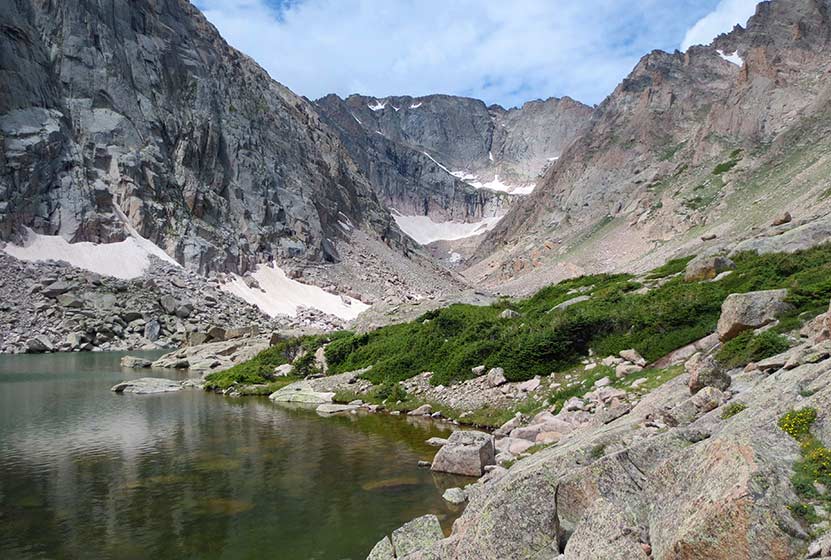
Solitude Lake Hike in Rocky Mountain National Park
Solitude Lake is an alpine lake situated in the heart of Rocky Mountain National Park. Solitude is aptly named, as it is hidden from the main trail system, situated high above Glacier Gorge in the shadow of Thatchtop and Arrowhead Peak. Because the hike to Solitude and its twin sister, Shelf Lake, require travel on unmaintained trails, it is best suited for more experienced hikers who are familiar with Rocky Mountain National Park and who are have honed their land navigation skills. Full details can be found in the trail profile for Shelf Lake. Explore the full Solitude Lake hike profile below for trail map, driving directions, and all the tips and resources for this hike in Rocky Mountain National Park.
Note: Rocky Mountain National Park now requires timed entry permits from May 27th through October 10th. See the RMNP permits page for more information.
Trail Snapshot: Solitude Lake in Rocky Mountain National Park
| Hike Distance | 9 miles Round Trip |
|---|---|
| Difficulty | Difficult |
| Duration | Approx 5-7 hrs Round Trip |
| Trail Type | Out and Back |
| Starting Elevation at Glacier Gorge Trailhead | 9240′ |
| Elevation Gain | Approx +2400′ |
| Seasons | Mid-Summer-September |
| Dogs | Prohibited in RMNP |
| Hike Trail Map | National Geographic Trails Illustrated Map |
| Denver Drive Time | 2 hr |
| Driving Directions to Glacier Gorge Trailhead | Click for Google Map |
| Town Nearest Hike | Estes Park, Colorado |
| Beauty | Waterfalls, wildlife: elk, deer, marmots; meadows, lakes, streams, wildflowers |
| Activities | Hiking, photography, fishing |
| Fee | Park Pass Required |
Solitude Lake is located about a quarter mile beyond Shelf Lake. Between the Shelf and Solitude are an unusual set of cascades, Shelf Lake Falls. Above the falls, you'll find a beautiful array of alpine wildflowers and breathtaking views of Longs Peak, Keyboard of the Winds, and the broad valley of Glacier Gorge. The hike up to Solitude take hikers past Alberta Falls, Mills Lake, and Shelf Creek Falls.
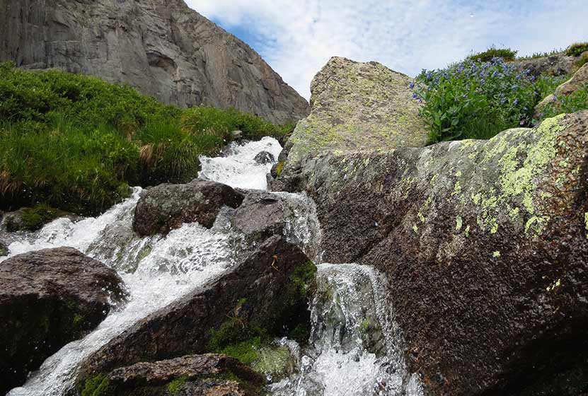
A final reminder: This hike is not on maintained trails, is a long hike, and demanding. Hikers should be familiar with RMNP and developed the skills needed for backcountry travel. A more detailed trail profile for locating the trail and a brief description of its course and hazards are can be found on the Shelf Lake hike profile page. If you are looking for a demanding hike on maintained trails in Rocky Mountain National Park, we would recommend exploring trail profiles for Sky Pond and Black Lake.

Tips & Resources for Hiking to Solitude Lake in Rocky Mountain National Park
- Recommended Map for Rocky Mountain National Park: The trail maps provided by Rocky Mountain National Park are usually sufficient. However, if you plan to hike RMNP often, we recommend purchasing a National Geographic Trails Illustrated Map.
- Packing List: Always pack the 10 Essentials. Download our Hiking Guide to get list and dayhiking packing checklist.
- Colorado Road Conditions: Colorado Road Conditions
- After the Hike: Inkwell & Brew Coffee
Weather
Map & Driving Directions
Click for Driving Directions

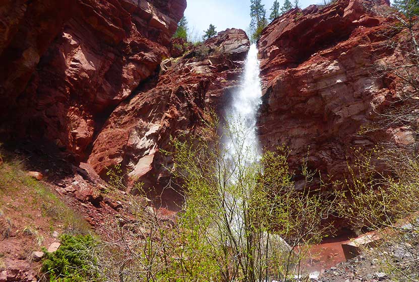
Cornet Falls Near Telluride Colorado
Cornet Falls in Telluride, Colorado, is an 80 foot waterfall and requires a short 1/4 mile hike to experience. The hike begins in town and affords views down into this beautiful Colorado mountain town. Explore the full Cornet Falls hike profile below for trail map, driving directions, and all the details you need to enjoy this hike in Telluride, CO.
Trail Snapshot: Cornet Falls Near Telluride, Colorado
| Hike Distance | 1/2 mile Round Trip |
|---|---|
| Difficulty | Easy |
| Duration | Approx 30 min |
| Trail Type | Out and Back |
| Starting Elevation | 8900′ |
| Elevation Gain | +220′ |
| Seasons | May-September |
| Dogs | Allowed On Leash |
| Hike Trail Map | Click for a Map of Telluride Area Trails |
| Denver Drive Time | 6.5 hrs |
| Driving Directions to Cornet Falls, Telluride | Click for Google Map |
| Town Nearest Hike | Telluride, Colorado |
| Beauty | Waterfalls, Views into Town of Telluride |
| Activities | Hiking |
Parking & Trailhead Information for Cornet Falls
The hike to Cornet Falls begins at the the Jud Weibe Trailhead in Telluride, Colorado. There is no designated parking area for this trailhead, so hikers will need to find acceptable parking along the streets or at public parking in town.
Tips & Resources for Hiking Cornet Falls Colorado
The hike from the Jud Weibe Trailhead to Cornet Falls is only a 1/4 mile. The trail makes its way through a lot of loose and slippery rock before it opens out to a backdrop of vermillion cliffs with 80 foot Cornet Falls jetting over the side. Stay to the right side of the creek for the proper trail leading to the waterfall.
- Wear Good Footwear: Because of the loose rock and slippery surfaces, be sure to wear a durable pair of shoes or boots that will give you good traction for this hike. Need a new pair of boots? Then be sure to check out our boot review of 3 recommended hiking boots.
- Explore More: For a longer adventure, hikers can stay on the Jud Wiebe trail and complete the 3 mile loop that features expansive views into the town of Telluride and ovf Bridal Veil Falls in the distance.
- Trail Map for Telluride Area: Trail Map Link
- Packing List: Always pack the 10 Essentials. Download our Hiking Guide to get list and dayhiking packing checklist.
- Colorado Road Conditions: Colorado Road Conditions
- After the Hike: Between the Covers Bookstore & Espresso Bar
- Photo: We would like to express our gratitude to Dan Wilnai for sharing such an amazing photograph of this hike to Cornet Falls.
Weather
Map & Driving Directions
Click for Driving Directions
Looking for more waterfalls near Denver? Explore our more than 50 Colorado Waterfall Hikes, our favorite Waterfall Hikes in Rocky Mountain National Park, or 7 Waterfalls within One Hour of Denver.
Eldorado Cascades at Walker Ranch
Eldorado Cascades is tucked back in Walker Ranch near Boulder, Colorado. It's an easy to moderate 1.25 mile hike from the Ethel Harrold Trailhead down to where South Boulder Creek winds through the park and crashes over the boulders blocking its path. Explore the full trail profile below for all the details: tips, trail map, and driving directions to the trailhead.
Trail Snapshot: Eldorado Cascades at Walker Ranch
| Hike Distance | 2.5 mile Round Trip |
|---|---|
| Difficulty | Moderate |
| Duration | Approx 1.5 hr Round Trip |
| Trail Type | Out and Back |
| Starting Elevation | 7000′ |
| Elevation Gain | Approx -500' to Cascades, +500 back to Trailhead |
| Seasons | Spring through Fall |
| Dogs | Allowed On Leash |
| Hike Trail Map | Click for a Map of Walker Ranch |
| Denver Drive Time | 1 hr |
| Driving Directions to Walker Ranch Ethel Harrold Trailhead | Click for Google Map |
| Town Nearest Hike | Boulder, Colorado |
| Beauty | Boulder Creek, Cascades, Wildlife: Birds, Elk |
| Activities | Hiking, picnic facilities, mountain biking, horseback riding |
Eldorado Cascades can be reached from several different trailheads that tie into the Walker Ranch Loop system. However, the shortest and probably easiest access is by starting at the Ethel Harrold Trailhead. See the directions driving directions links on this page, and be sure to make note of your last couples turns because cell phone services are spotty.
The drive up to the trailhead on Flagstaff Road is a beautiful one, but do be aware of the many hikers, climbers, and cyclists along the road. After Flagstaff road, the two roads that lead to the trailhead, Pika, then Bison, are improved dirt roads. These were recently graded when we visited (early April) and were fine to drive. However, 4-wheel drive is probably necessary during the winter months or after early Spring rains or snowfall. The trailhead parking area has a pit toilet and information board. If you are interested in birdwatching, you'll find a Birds of Walker Ranch Chechlist at the board.
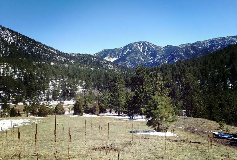
The Hike to Eldorado Cascades
The hike begins with expansive views of Walker Ranch and out towards Eldorado Canyon State Park (pictured above). The air was full of the scent of juniper trees, and we found abundant Elk sign in the meadows near the trailhead. The trail winds down to a intermittent stream that was gushing with the early Spring snowmelt. A bridge buried in snow leads across the creek, then the trail skirts the hillside for most of the hike, gradually working its way down to a junction with the Walker Ranch Loop Trail. At the junction, the trail to Boulder Creek and Eldorado Cascades is to the right and takes hikers further downhill to a bridge that crosses South Boulder Creek.
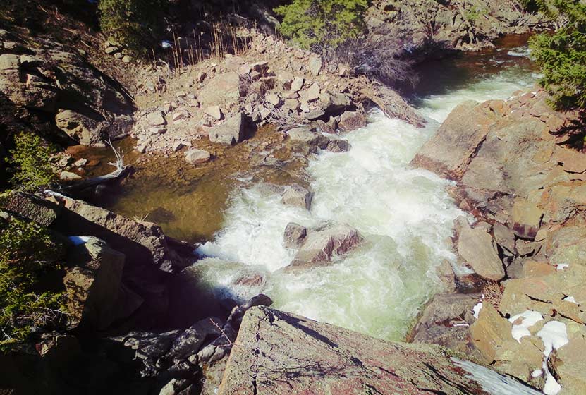
The sound of water is almost always within earshot, and the chirps of a variety of birds fill the air. Shortly before the bridge, hikers may notice a "To Eldorado Canyon" sign and trail on the left side of the Walker Ranch Trail. This leads to Eldorado Canyon State Park, about 3.5 miles away, but does not lead to the cascades. The cascades can be found almost immediately after crossing the bridge that spans South Boulder Creek. Here the trail becomes a series of uneven rock stairs that lead to the top of the cascades (pictured above is view from the top).
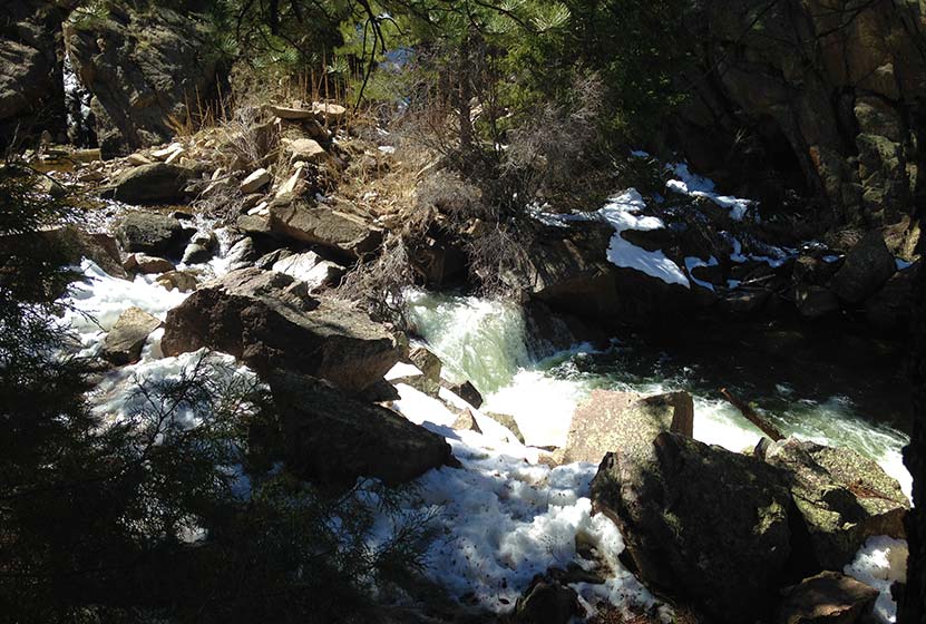
"Eldorado Falls" seems to be a local and unofficial name given to this set of cascades. The trail map simply marks them as "falls." On the back side of the cascades, South Boulder Creek seems to disappear under massive boulders that block its path. Here the water slips under the rock then shoots out on the other side in a series of small cascades. The water pools, then pours over another lower cascades (pictured above) before returning to calmer waters.
The hike back is mostly uphill, but it's only about a +500' of elevation gain. The park is open in the winter; however, the trail from the Ethel Harrold trailhead down to the Walker Ranch Loop might become difficult to discern after a blanket of snow. So, the ideal times are Spring through Fall.

Tips & Resources for Hiking to Eldorado Cascades
- Come Prepared in Spring and Winter: Because the trail is mostly in shade of ponderosa pines, the snow and ice can settle in during both winter and spring. Therefore, we recommend Trekking Poles and/or Traction Devices for this trail (I wish I had brought mine).
- Exercise Caution Around the cascades: The area around Eldorado Cascades is rocky and uneven. The cascades are also difficult to photograph because of how it's tucked back into the canyon. For this reason, exercise caution along the slippery rock and near the waters of South Boulder Creek.
- Trail Map for Walker Ranch: Trail Map Link
- Packing List: Always pack the 10 Essentials. Download our Hiking Guide to get list and dayhiking packing checklist.
- Colorado Road Conditions: Colorado Road Conditions
- After the Hike: Ozo Coffee in Boulder
Weather
Map & Driving Directions
Click for Driving Directions
Looking for waterfalls near Denver? Explore our more than 50 Colorado Waterfall Hikes, our favorite Waterfall Hikes in Rocky Mountain National Park, or 7 Waterfalls within One Hour of Denver.
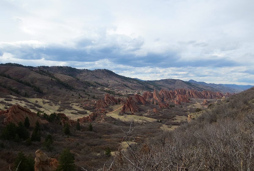
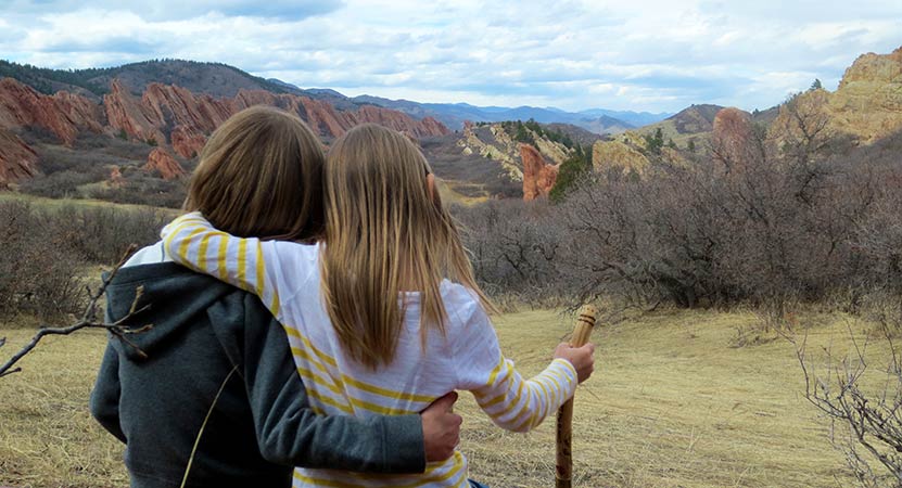
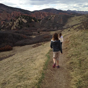
South Rim Loop Trail at Roxborough State Park
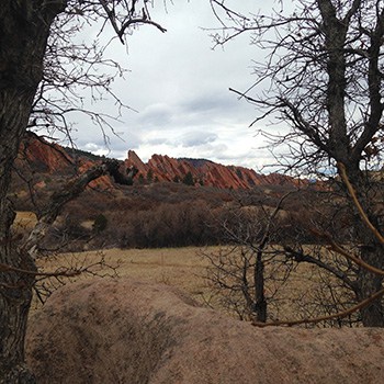
The South Rim Loop Trail at Roxborough State Park is a moderate hike that leads to breathtaking views of the red rock formations that make this Colorado State Park famous. It's a perfect hike for a weekend afternoon, or a great choice for visiting family and friends. We also put this on our list for great hikes to take if you want to acclimatize before hiking into higher altitudes deeper in the mountains. Read further to explore the trail details, tips, and to get the trail map for this adventure in Roxborough State Park.
Roxborough State Park is like the Garden of the God's of Denver. Nestled against the foothills south Littleton, Colorado, it makes for a quiet escape from the sounds of the city. The South Rim Trail provides some of the best vantage points for photography of the Fountain and Morrison formations, the same rock that forms sister parks, Garden of the Gods in Colorado Springs, and Red Rocks Park in Morrison.
Trail Snapshot: South Rim Loop Trail at Roxborough State Park
| Hike Distance | 3 miles |
|---|---|
| Difficulty | Moderate |
| Duration | Approx 1.5 hr |
| Trail Type | Loop |
| Starting Elevation | 6200′ |
| Elevation Gain | Approx +250′ |
| Seasons | Year Round |
| Dogs | Prohibited in Roxborough State Park |
| Hike Trail Map | Click for a Map of Roxborough State Park |
| Denver Drive Time | 45 min |
| Driving Directions to Roxborough State Park | Click for Google Map |
| Town Nearest Hike | Littleton, Colorado |
| Beauty | Red rock formations, meadows, wildlife: mule deer, eagles, foxes, birds |
| Activities | Hiking, birdwatching, Visitors’ Center |
| Fee | Entrance Fee or State Parks Pass Required |
Parking and Trailhead Information
The last two miles of access road into Roxborough State Park are a maintained dirt road, but it can get washboarded and can be tough on the car. Still, it's not a long drive in. Undulating green hills can be seen to the west where deer and antelope graze. Roxborough can fill up during it's busiest hours on the weekend. If that's the case, you can wait until enough vehicles exit the park then drive in. My guess is that the peak times are around 10AM-2PM. If the line looks long, you can always turn around and head over to Waterton Canyon or to South Valley Park--both are great options.
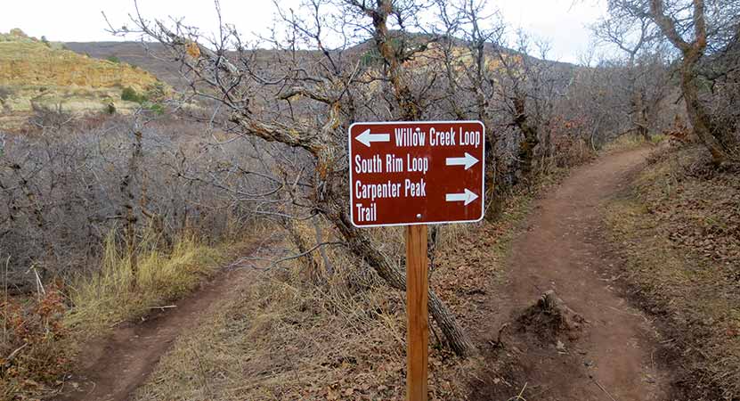
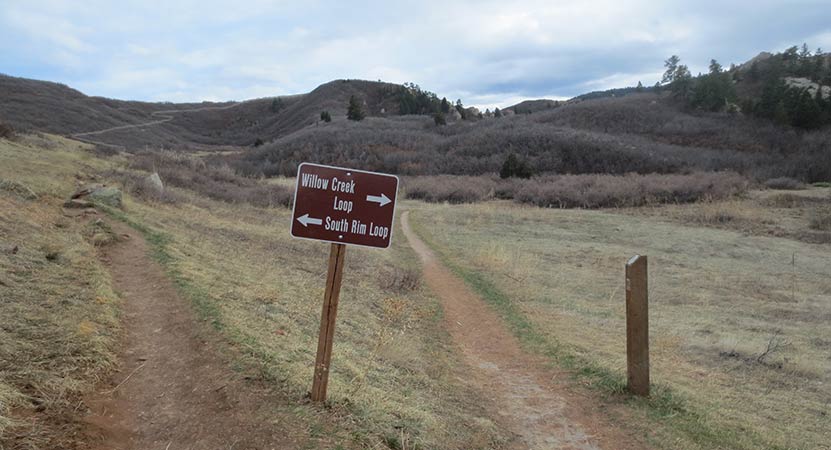
The South Rim trail begins just west of the visitor center and makes its way through tunnels of scrub oak. This first trail segment takes you to several different destinations: the Willow Creek Loop, Carpenter Peak, and Elk Valley.
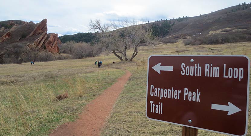
The trail will eventually come to a small meadow with a lone cottonwood tree. Here the trail forks and the trail to the lef leads to the rest of the South Rim Trail. It crosses a small brook via a footbridge and into an area that our kids kept calling the "magical forest." The way the light plays in Roxborough State Park is enchanting. I think it has something to do with how the hogback formations and the red rocks filter the light coming into the valley.
About 1 mile into the hike, the trail begins to climb. We've rated this trail as moderate because the climb may be challenging for those not acclimated to the altitude or who are not in great shape. The great news is that there are benches placed at regular intervals along the trail. A couple of these bench sites offer incredible overlooks into the park and are ideal points for photographing fountain valley. Most of the benches offer shade in bowers under fir and scrub oak trees.
The South Rim Trail makes its way over the top of a bright and orange cliff band that dominates the southern end of the park for most of the hike. At the highest point, a very short spur trail affords hikers views to the east, and another viewpoint on the descent offers views to the north, all the way into the city of Denver.
Be mindful of the loose gravel as the trail descends back into the valley. Back on the valley floor, the trail will fork again. To the left (west) will take hikers onto the Willow Creek trail, adding approximately 1/2 mile onto the loop back to the visitor center, making it a 3.5 mile hike. Or you can continue North for approximately 1/2 mile back the the parking area.

Tips & Resources for Hiking the South Rim Loop in Roxborough
- Loop Hiking Direction: This description of the South Rim Loop is hiked as counter-clockwise. Just reverse the description for hiking the trail to hike the loop clockwise.
- Hiking in Winter: If you plan to hike the South Rim Trail in the winter, it is advised that you have traction devices like YakTrax because much of the trail will be in shadow, and ice will likely form on the trail.
- Trail Map for Roxborough State Park: Trail Map Link
- Packing List: Always pack the 10 Essentials. Download our Hiking Guide to get list and dayhiking packing checklist.
- Colorado Road Conditions: Colorado Road Conditions
- After the Hike: Waterton Tavern in Roxborough
Weather
Map & Driving Directions
Click for Driving Directions


Arthur's Rock Trail in Lory State Park
The Arthurs Rock trail in Lory State Park near Fort Collins, Colorado ends with a beautiful panoramic views. You'll pass through meadows, forest, then end your hike with a scramble to the top of Arthur's Rock. Dogs are allowed on a leash, just be sure to bring plenty of water as there are not many places to access drinking water.
| Hike Distance | 3.4 miles RT |
|---|---|
| Difficulty | Moderate |
| Duration | Approx 1 hr 15 min Round Trip |
| Trail Type | Out and Back |
| Starting Elevation | 5600′ |
| Elevation Gain | +1180′ |
| Seasons | Spring to Fall |
| Dogs | Allowed On Leash |
| Hike Trail Map | Click for a Map of Arthur’s Rock Trail in Lory State Park |
| Denver Drive Time | 1 hr 25 min |
| Driving Directions to Arthur’s Rock Trail in Lory State Park | Click for Google Map |
| Town Nearest Hike | Fort Collins, Colorado |
| Beauty | Views of Horsetooth Lake, views of the Front Range, forests, and meadows, wildlife: elk, bobcat, and many bird species |
| Activities | Hiker only trail, but park offers picnic areas, horseback riding, mountain biking, canoeing, & kayaking |
Arthur's Rock History
The place got its name from Arthur Howard who was the one who, along with his brother, Charlie, sold this piece of land. For more information on the history of Arthur's Rock and Lory State Park, visit this page.
Tips & Resources for Hiking Arthur’s Rock Trail in Lory State Park :
- TIP: There is a visitor's center near the Lory State Park entrance.
- TIP: At the summit of Arthur's Rock, there is a beautiful view of Horsetooth Reservoir and the Front Range available.
- Trail Map for Lory State Park: Trail Map Link
- Colorado Road Conditions: Colorado Road Conditions
- After the Hike: The Colorado Room
- Photo: We would like to express our gratitude to Luci Westphal for sharing a great photo of her hike to Arthur's Rock at Lory State Park. Check out her video from this hike.
Weather
Map & Driving Directions
Click for Driving Directions to Lory State Park
Panorama Point Trail in Corwina Park
If you are fond of panoramic views, then the Panorama Point Trail in Corwina Park is what you may be looking for. At the top of this trail you will find a beautiful view that looks out to the mountains and the plains. This medium-difficulty hike also lets you hike along a babbling brook. Check out our snapshot below for a trail map, driving directions to the trailhead and more details.
Trail Snapshot: Panorama Point Trail in Corwina Park
| Hike Distance | 2.4 miles Round Trip |
|---|---|
| Difficulty | Moderate |
| Duration | Approx 1 hr Round Trip |
| Trail Type | Out and Back |
| Starting Elevation | 6715′ |
| Elevation Gain | Approx +690′ |
| Seasons | Spring through Fall |
| Dogs | Allowed On Leash |
| Hike Trail Map | Click for a Map of Panorama Point Trail in Corwina Park |
| Denver Drive Time | 40 min |
| Driving Directions to Panorama Point Trail in Corwina Park | Click for Google Map |
| Town Nearest Hike | Evergreen, Colorado |
| Beauty | Mountain peak views, Bear Creek |
| Activities | Picnic area, fishing, hiking |
Corwina Park has two different trailheads, an east parking lot and a west lot (I don't believe they are named this way--it's just the geographic location). Hiking from the west lot (second lot you come to driving from Morrison/Denver), provides the shortest hiking route. The trail here follows a seasonal brook; its sounds and the shade from the trees make this a pleasant approach to Panorama Point.
Tips & Resources for Hiking Panorama Point Trail in Corwina Park:
- TIP: If you hike during winter, wearing a traction device like YakTrax is ideal, as well as using trekking poles.
- Trail Map for Corwina Park: Trail Map Link
- Colorado Road Conditions: Colorado Road Conditions
- After the Hike: Beau Jo’s Pizza
- Photo: We would like to express our gratitude to Ben Deutsch for sharing such an amazing photograph of this hike.
Weather
Map & Driving Directions
Click for Driving Directions
