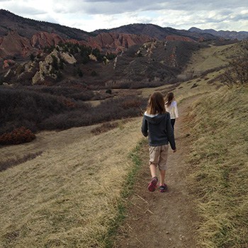
The South Rim Loop Trail at Roxborough State Park is a moderate hike that leads to breathtaking views of the red rock formations that make this Colorado State Park famous. It’s a perfect hike for a weekend afternoon, or a great choice for visiting family and friends. We also put this on our list for great hikes to take if you want to acclimatize before hiking into higher altitudes deeper in the mountains. Read further to explore the trail details, tips, and to get the trail map for this adventure in Roxborough State Park.
Roxborough State Park is like the Garden of the God’s of Denver. Nestled against the foothills south Littleton, Colorado, it makes for a quiet escape from the sounds of the city. The South Rim Trail provides some of the best vantage points for photography of the Fountain and Morrison formations, the same rock that forms sister parks, Garden of the Gods in Colorado Springs, and Red Rocks Park in Morrison.
Trail Snapshot: South Rim Loop Trail at Roxborough State Park
| Hike Distance | 3 miles |
|---|---|
| Difficulty | Moderate |
| Duration | Approx 1.5 hr |
| Trail Type | Loop |
| Starting Elevation | 6200′ |
| Elevation Gain | Approx +250′ |
| Seasons | Year Round |
| Dogs | Prohibited in Roxborough State Park |
| Hike Trail Map | Click for a Map of Roxborough State Park |
| Denver Drive Time | 45 min |
| Driving Directions to Roxborough State Park | Click for Google Map |
| Town Nearest Hike | Littleton, Colorado |
| Beauty | Red rock formations, meadows, wildlife: mule deer, eagles, foxes, birds |
| Activities | Hiking, birdwatching, Visitors’ Center |
| Fee | Entrance Fee or State Parks Pass Required |
Parking and Trailhead Information
The last two miles of access road into Roxborough State Park are a maintained dirt road, but it can get washboarded and can be tough on the car. Still, it’s not a long drive in. Undulating green hills can be seen to the west where deer and antelope graze. Roxborough can fill up during it’s busiest hours on the weekend. If that’s the case, you can wait until enough vehicles exit the park then drive in. My guess is that the peak times are around 10AM-2PM. If the line looks long, you can always turn around and head over to Waterton Canyon or to South Valley Park–both are great options.
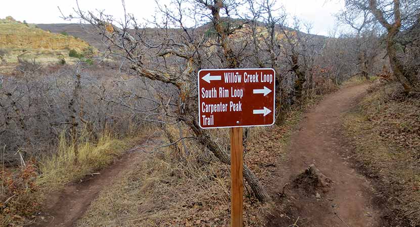
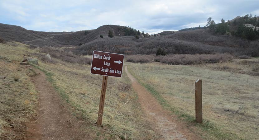
The South Rim trail begins just west of the visitor center and makes its way through tunnels of scrub oak. This first trail segment takes you to several different destinations: the Willow Creek Loop, Carpenter Peak, and Elk Valley.
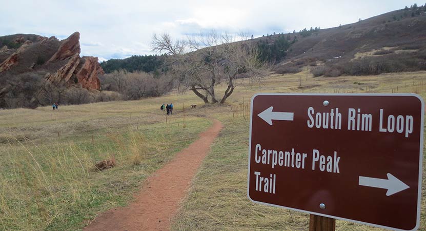
The trail will eventually come to a small meadow with a lone cottonwood tree. Here the trail forks and the trail to the lef leads to the rest of the South Rim Trail. It crosses a small brook via a footbridge and into an area that our kids kept calling the “magical forest.” The way the light plays in Roxborough State Park is enchanting. I think it has something to do with how the hogback formations and the red rocks filter the light coming into the valley.
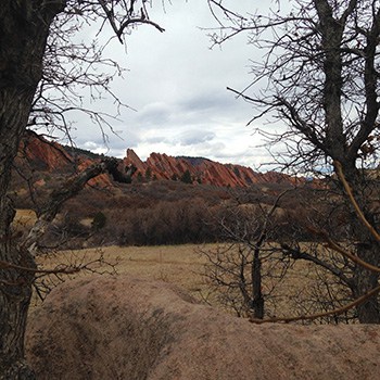
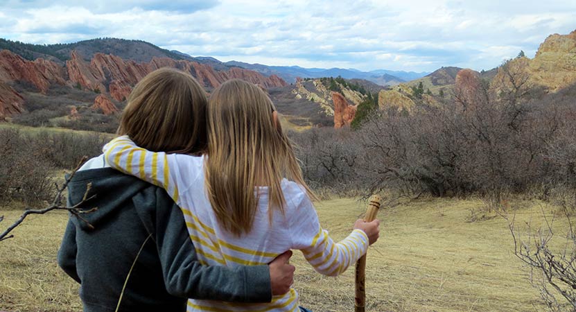
About 1 mile into the hike, the trail begins to climb. We’ve rated this trail as moderate because the climb may be challenging for those not acclimated to the altitude or who are not in great shape. The great news is that there are benches placed at regular intervals along the trail. A couple of these bench sites offer incredible overlooks into the park and are ideal points for photographing fountain valley. Most of the benches offer shade in bowers under fir and scrub oak trees.
The South Rim Trail makes its way over the top of a bright and orange cliff band that dominates the southern end of the park for most of the hike. At the highest point, a very short spur trail affords hikers views to the east, and another viewpoint on the descent offers views to the north, all the way into the city of Denver.
Be mindful of the loose gravel as the trail descends back into the valley. Back on the valley floor, the trail will fork again. To the left (west) will take hikers onto the Willow Creek trail, adding approximately 1/2 mile onto the loop back to the visitor center, making it a 3.5 mile hike. Or you can continue North for approximately 1/2 mile back the the parking area.

Tips & Resources for Hiking the South Rim Loop in Roxborough
- Loop Hiking Direction: This description of the South Rim Loop is hiked as counter-clockwise. Just reverse the description for hiking the trail to hike the loop clockwise.
- Hiking in Winter: If you plan to hike the South Rim Trail in the winter, it is advised that you have traction devices like YakTrax because much of the trail will be in shadow, and ice will likely form on the trail.
- Trail Map for Roxborough State Park: Trail Map Link
- Packing List: Always pack the 10 Essentials. Download our Hiking Guide to get list and dayhiking packing checklist.
- Colorado Road Conditions: Colorado Road Conditions
- After the Hike: Waterton Tavern in Roxborough
Weather
Map & Driving Directions
Click for Driving Directions


Trails are clear and mostly dry in Roxborough, but I would recommend calling the state park office to get the best information.
Be prepared! I wanted to take someone special to see what looked like a beautiful experience. Unfortunately, due to the popularity of Roxborough, there was a 20-40 minute wait in order to enter the park, and this is in March, albeit a very unseasonably warm weekend! Will have to try again!
Great hike, but not sure I would suggest it for a summer afternoon. We started it around 12:30pm and got full sun exposure for more than just the back half of the loop headed to the parking lots. Great views and gradual elevation gain, but likely a better choice for the morning or a cloudier day.
Right now with the ozone and smoke problems, and the heat build-up, I recommend to go early. Yesterday (July 27, 2021) at 5AM (when the park opens) I was the only one there, starting the South Rim loop from the lower end, by the utility shed you first encounter when turning into the park. (It’s not a rest room, despite what Google maps says – rest rooms are just a little bit further up at the next parking lot.)
The trailhead is a bit hard to spot, it’s near the middle of the small first parking lot, going down to the creek, and across a foot bridge.
For the first 15 minutes I used a headlamp; the air was cool and clear, even breezy at times; soon there was enough twilight to walk comfortably (but watch your step, even footing is rare along there).
By 5:50 I was at the lookout, waiting to see the sun come up over Kansas. Blood red – an indicator of the air quality… Soon the jagged rocks below were bathed in the first light, bringing out the orange color that later turns more yellow when the sun goes higher up.
The start from the lower end of the loop means you get the steeper portion done first, then the descent is easier when the heat comes on.