If lakes are your favorite destination, then the hike to The Loch should be added to your trail list in Rocky Mountain National Park. It is a moderately difficult hike on the eastern side of the park where you can hike along the edge of the lake, fish for trout, or come early in the morning to photograph the iconic scenery in Loch Vale. Explore the full trail profile below for driving directions to the trailhead, trail map, and other destinations that can be added to the hike.
The Loch is the Gaelic name given to this lake, the major destination along the Loch Vale trail and the source of Icy Brook, the stream that spills from its eastern edge. Because of it’s beauty and the wide variety of vantage points for outstanding scenery, the Loch is popular with photographers. We’ve found it to be a perfect hike to a tranquil spot to take in the views and enjoy a picnic lunch.
Note: Rocky Mountain National Park now requires timed entry permits from May 27th through October 10th. See the RMNP permits page for more information.
Trail Snapshot: The Loch in Rocky Mountain National Park
| Hike Distance | 5.5+ mile Round Trip |
|---|---|
| Difficulty | Moderate |
| Duration | Approx 3 hr Round Trip |
| Trail Type | Out and Back |
| Starting Elevation | 9240′ at Trailhead |
| Elevation Gain | Approx +1000′ |
| Seasons | June-September |
| Dogs | Prohibited in RMNP |
| Hike Trail Map | Click for a Map of The Loch |
| Denver Drive Time | 2 hr |
| Driving Directions to Glacier Gorge Trailhead | Click for Google Map |
| Town Nearest Hike | Estes Park, Colorado |
| Beauty | Lake, wildflowers, waterfall, wildlife: elk, deer, birds |
| Activities | Hiking, fishing, photograph |
| Fee | Park Pass Required |
Parking & Trailhead Information
The trail to the Loch, and the destinations beyond, begins at either the Glacier Gorge Trailhead (see driving directions above), or at the Bear Lake Trailhead (driving directions). Because the Glacier Gorge Trailhead has a much smaller lot, you may need to drive further up to Bear Lake. There you’ll find a short connector trail that will put you on the path down and over to the Glacier Gorge Trail system. In the event that parking at Bear Lake is full, you’ll then need to park at the Park & Ride near the Bierstadt Trailhead and take the bus into the trailhead. This service runs 7am to 7PM and more information on the RMNP shuttle bus routes can be found at this link.
The Hike to The Loch
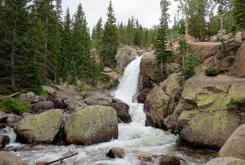
The first destination that you can’t and don’t want to miss is at .8 miles, Alberta Falls (photo above). The trail then climbs toward an eventual trail junction. The way to the Loch is to follow the Glacier Gorge/Loch Vale trail that bears right and ascends for about another .5 mile to another trail junction. At this second junction the trail to the left will take hikers to Glacier Gorge, and the trail to the right takes hikers on a jaunt to Lake Haiyaha. The middle trail leads onto the Loch Vale Trail, and up to the Loch.
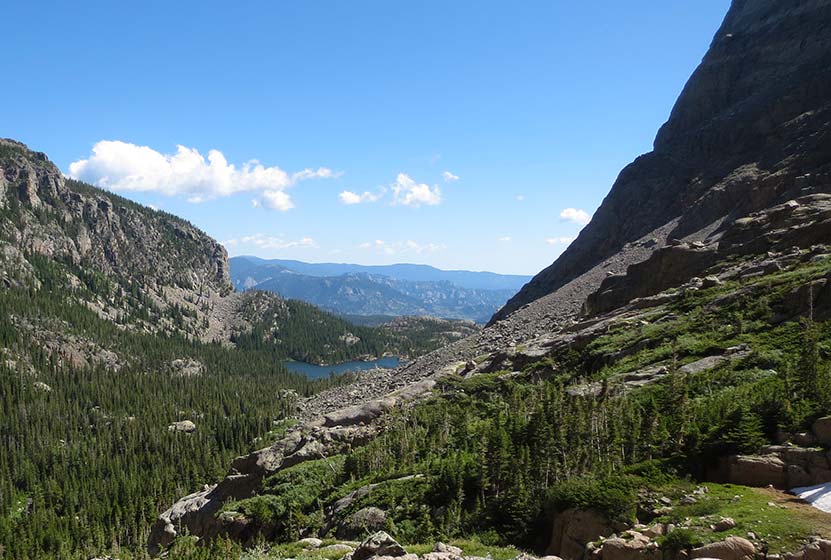
Pictured Above: The Loch as seen from the heights near Timberline Falls. Take care to stay the trail as you explore the Loch. It’s a heavily visited area with equally heavy impact. The Loch hosts a variety of trout: brookies, cutbows, cuthroats, and rainbows. Mayflies and Caddis flies are common hatches, and black or chernobyl ants can be a particularly good terrestrial pattern to use at the Loch. The wind can kick up along the lake, especially as the rises and warms the rock walls that surround the lake. Some areas on the southern side provide calmer waters. Photographers will find morning sunrises the best time to photograph the amazing landscape of the lake and mountains.
List and Links of Destinations Along the Loch Vale Trail
1. Alberta Falls – @ .8
2. The Loch – @ 2.7 miles
3. Timberline Falls – @ 4 miles
4. Lake of Glass -@ 4.2 miles
5. Sky Pond – @ 4.6 miles
Tips & Resources for Hiking to the Loch in RMNP:
- Hike Further: Be sure to hike and additional approx 1.25 mile (one-way) to Timberline Falls to see one of the most beautiful waterfalls in Rocky Mountain National Park.
- Get There Early: There are two important reasons to begin your hikes early in the morning in Rocky Mountain National 1)The trail head parking lots fill up early, and 2) in the Summer months, thunderstorms will form in the early afternoon.
- Parking: If the parking lot is full at Glacier Gorge Trailhead, there is a shuttle available to take you to the trailhead. This service runs 7am to 7PM and more information on the RMNP shuttle bus routes can be found at this link.
- Trail Map for Bear Lake Corridor: Trail Map Link
- Recommended Map for Rocky Mountain National Park: The trail maps provided by Rocky Mountain National Park are usually sufficient. However, if you plan to hike RMNP often, we recommend purchasing a National Geographic Trails Illustrated Map.
- Colorado Road Conditions: Colorado Road Conditions
- After the Hike: Inkwell Brew Coffee
Weather
Map & Driving Directions
Click for Driving Directions


