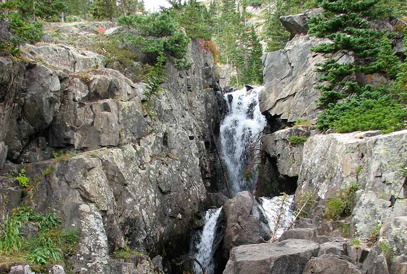
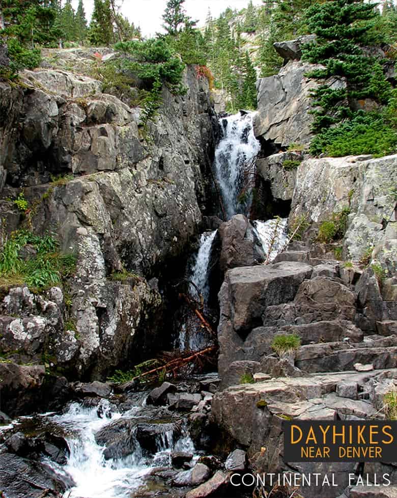
Continental Falls Hike Near Breckenridge
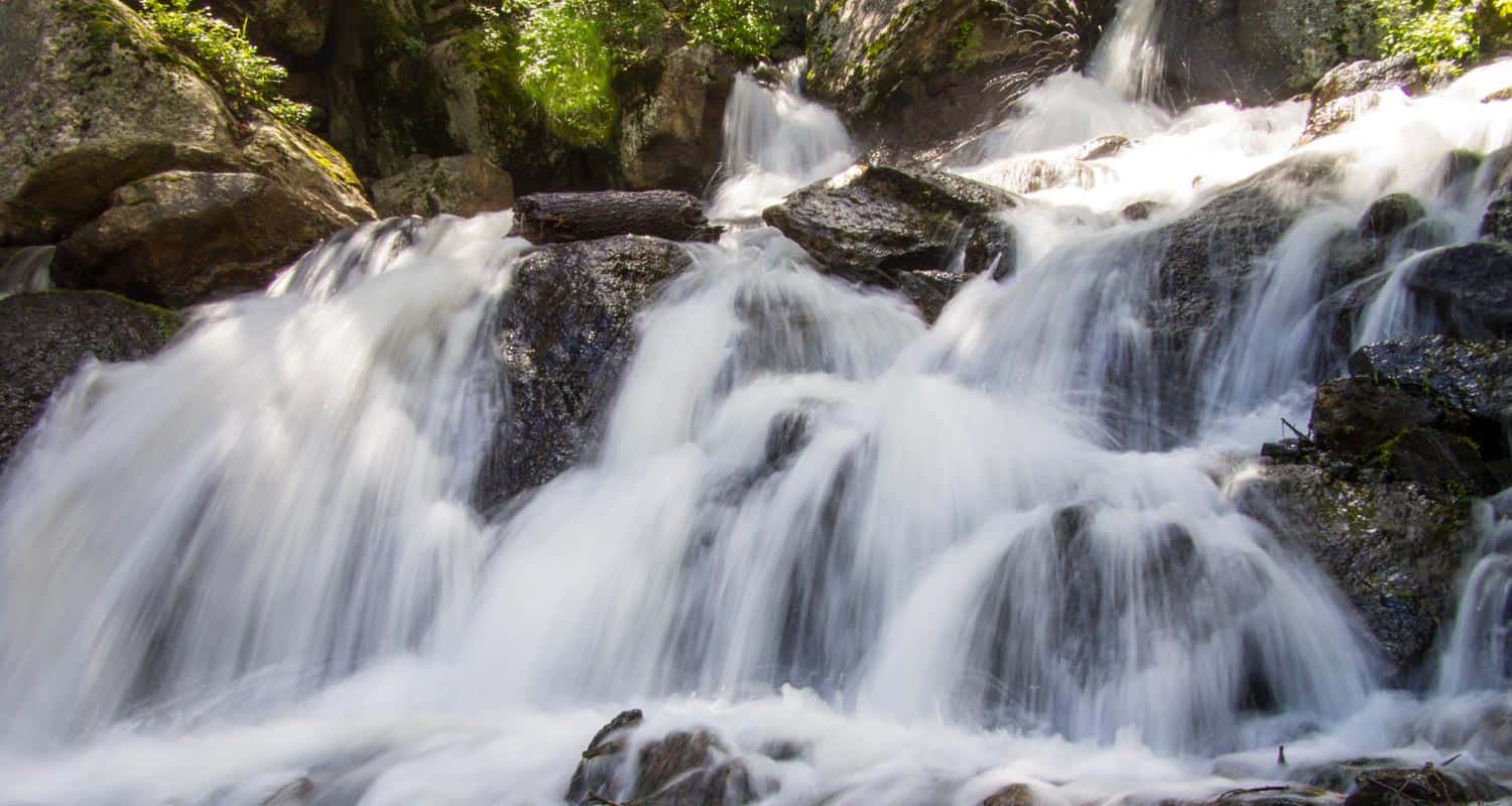
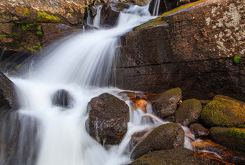
Continental Falls crashes through cracks in the granite sides of the mountains near Breckenridge Colorado. It's a moderate 2.5 mile uphill hike to the base of the waterfall. The 1000+ feet of elevation gain require some bodily exertion, but it's worth the effort. Located on the eastern slopes of the Mosquito Range, waterfall finds its source in the high mountain Mohawk Lakes as they spill out into Spruce Creek and make their way down the mountainside. The trail boasts spectacular mountain views, lakes, and the ruins of an old mining operation. Explore the full Continental Falls hike profile below for trail map, driving directions, and more tips and details to help you enjoy this hike near Breckenridge.
Trail Snapshot: Continental Falls Trail near Breckenridge, Colorado
| Hike Distance | Approx 5 miles Round Trip |
|---|---|
| Difficulty | Moderate |
| Duration | Approx 4 hrs |
| Trail Type | Out and Back |
| Starting Elevation | 10380′ |
| Elevation Gain | +1070′ |
| Seasons | Year Round |
| Dogs | Allowed On Leash |
| Hike Trail Map for Continental Falls | Click for a Map |
| Denver Drive Time | 1 hr 40 min |
| Driving Directions to Spruce Creek Trailhead | Click for Google Map |
| Town Nearest Hike | Breckenridge, Colorado |
| Beauty | waterfall, lakes, cabin ruins, creek, mountain views |
| Activities | Hiking, photography, horseback riding, fishing |
Parking & Trailhead Information for Continental Falls Hike
From Breckenridge, follow CO 9 South to The Spruce Creek Road. This is found on the right/west approximately 2.5 miles from the south end of town (junction of Main and South Park Ave). The trailhead for this hike to Continental Falls is located approximately 1.1 mile up Spruce Creek Road.
The Hike: Continental Falls Trail
The hike up to Continental Falls follows the Spruce Creek Trail. It's marked with blue diamond blazes making the trail easy to find and follow. Just shy of a 1/2 mile into the hike, the trail will cross Spruce Creek via a footbridge. At this point, the forest opens up a bit to views of my Helen in the distant west.
About 1.7 miles into the hike, the Spruce Creek trail will intersect with the Wheeler Trail. At this junction, continue straight on Spruce Creek Trail. At approximately 2 miles, the Spruce Creek trail will join up with the 4WD road, for a short jaunt past a small dam, then will connect back in with the Spruce Creek trail.
At about 2.5 miles into the hike, the trails reaches another junction. The left-hand trail leads up to Continental Falls and beyond to Mohawk Lakes. This segment of the trail is one of my favorites, as it leads past the ruins of a mining operation complete with cabins, mine shaft, and old mining equipment. Be sure to exercise caution and read the warning signs around such areas. At approximately 2.6 miles into the hike, the trail will arrive at Continental Falls. After taking in the waterfall, hikers often opt to go further up to gain incredible mountain peak and mountain range views at Mohawk Lakes.
Tips & Resources for Hiking the Continental Falls Trail
- TIP: There is a mine ruins off trail nearby. Be careful as there is a warning sign that it could collapse and may produce dangerous gases.
- Trail Map for Continental Falls: Trail Map
- Packing List: Always pack the 10 Essentials. Download our Hiking Guide to get the list and dayhiking packing checklist.
- Colorado Road Conditions: Colorado Road Conditions
- After the Hike: The Crown
Weather
Map & Driving Directions
Click for Driving Directions

Looking for more waterfalls near Denver? Explore our more than 50 Colorado Waterfall Hikes, our favorite Waterfall Hikes in Rocky Mountain National Park, or 7 Waterfalls within One Hour of Denver.
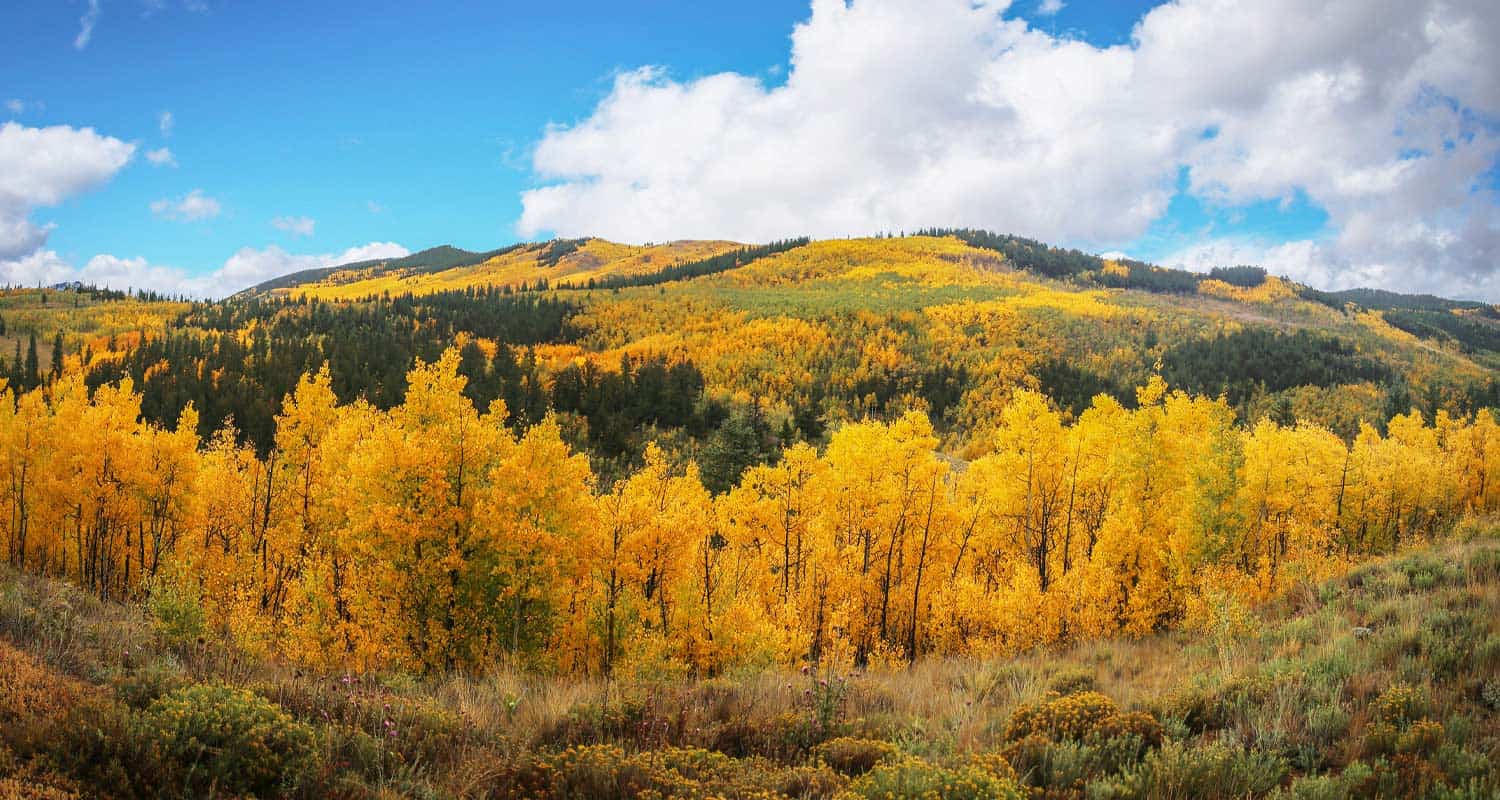
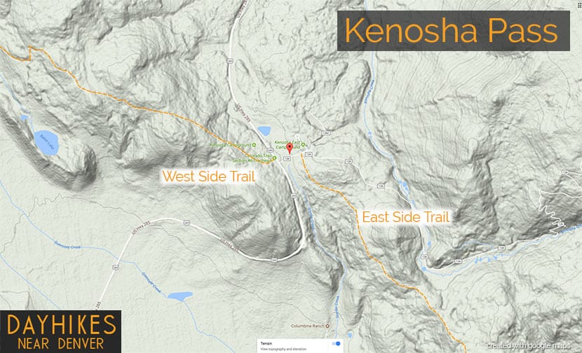
Kenosha Pass Hiking Trails
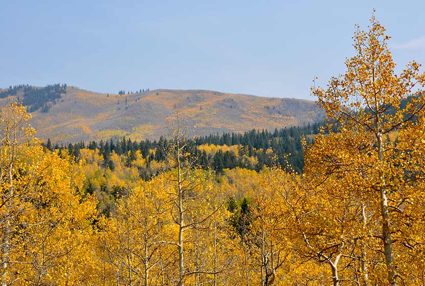
Kenosha Pass is probably the best place to view the changing aspens near Denver. It offers both an East and West trail option with gradual ascents to stunning views. Starting at 10,000' the initial elevation gain on the trails make for easy to moderately strenuous hikes, all depending on how far one decides to travel on these beautiful segments of the Colorado Trail. Vantage points can be accessed about 1/2 mile up both trails offering views down into the high country plains of South Park and out to the Rocky Mountains. Explore the full Kenosha Pass hike profile below for trail map, driving directions, and more tips and details to help you enjoy this Colorado hike.
Trail Snapshot: Kenosha Pass Colorado
| Hike Distance | <1 to 14.4 miles Round Trip |
|---|---|
| Difficulty | Easy to Moderate |
| Duration | Depends on Segment Hiked |
| Trail Type | Out and Back |
| Starting Elevation | 10,000′ |
| Elevation Gain | Approx +400' for shorter hikes |
| Seasons | Year Round |
| Dogs | Allowed On Leash |
| Hike Trail Map | Click for a Map of Kenosha Pass |
| Denver Drive Time | 1 hr 30 min |
| Driving Directions to Kenosha Pass East Parking Area | Click for Google Map |
| Town Nearest Hike | Grant, Colorado |
| Beauty | aspen groves, creek, wildflowers, mountain range views, views of South Park, wildlife: moose |
| Activities | Hiking, mountain biking, horseback riding, photography, snowshoeing, camping |
Parking & Trailhead Information for Kenosha Pass Hike
Kenosha Pass is located about 65 miles southwest of Denver along US 285. From Denver, take US 285 towards Bailey, Colorado. From Bailey, continue driving approximately 19 miles on 285 to the Kenosha Pass Trailhead. The trailhead parking area is located on both East (left when coming from Denver) and West (right side when coming from Denver) of 285. There is additional parking on the East side after crossing a cattle gate. Parking can get tight in the Autumn when the aspens are at their peak, so be considerate of others and the land as you park your vehicle. It's about a 90 minute drive from Denver. Restrooms can be found on both trailheads.
Hiking the Kenosha Pass Trail
Two Hiking Options and Where the Trails Begin
The hiking trails at Kenosha Pass easy to moderate in difficulty and can be done by hikers of all experience levels. At Kenosha Pass, the Colorado Trail, which goes from Denver to Durango, intersects with US Highway 285. This creates an East side trail option and an West side trail option. Both offer incredible views down into the South Park plains of Colorado and out to the often snow-capped peaks of the Mosquito Range.
Hiking the East Side of Kenosha Pass
Hikers can pick up the Colorado Trail after crossing the cattle gate (if parked along 285) and hiking along the dirt road that leads to the restrooms that are near the 2nd parking area (after the cattle gate). The Trailhead is located just before the 2nd parking area, and will be located on the right (south). While most visitors park, take a jaunt into the aspens, snap a few photos and leave, the more stunning views await those who venture further south along the trail. The initial trail segment enters with a gradual ascent into the aspens, then at 1/2 a mile into the hike the woods opens up to incredible views into South Park.
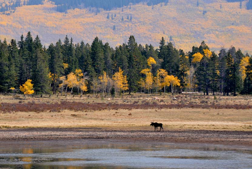
South Park is a high mountains plains area that stretches out mile-upon-mile to its western and norther mountain borders, the Collegiate Peaks and the Mosquito Range of the Rocky Mountains. The climb continues at a gradual pace and hikers will emerge to a second panorama at 1.5 miles. This is a great place to turn-around, making it into a 3 mile out-ant-back hike. Of course, hikers can continue on the trail all the way back into Denver, but that requires a multi-day backpacking trip. As always, keep eyes peeled for changing weather, and pack the 10 Essentials. If you are wondering what should be in your daypack, be sure to download our free Dayhike Hiking and Packing Guide. As for wildlife, moose are often spotted on this side along the lake near the trailhead.
Hiking the West Side of Kenosha Pass
The West Side Trail at Kenosha Pass can be picked up immediately on the West side of 285. The trail enters conifer and aspen forest, making a gentle climb toward the northwest until popping out of the trees to breathtaking views down into South Park and the Mosquito Range. After this viewpoint, the trail travels a short distance uphill, then makes its way down toward Guernsey Creek. The distance from the trailhead to Guernsey Creek is approximately 3 miles, making this a 6 mile out-and-back adventure. Because this is the Colorado Trail, it does continue west, offering multi-day backpacking options that lead all the way to Durango, Colorado.
Tips & Resources for Hiking the Kenosha Pass Trail
- TIP: Bring sunscreen for protection against the sun.
- TIP: One the east side of the highway, there is another parking lot with a lot of bathrooms.
- Trail Map: Map for Trailhead Locations
- Trails Illustrated Kenosha Pass Map: Trails Illustrated Map Link
- Packing List: Always pack the 10 Essentials. Download our Hiking Guide to get the list and dayhiking packing checklist.
- Colorado Road Conditions: Colorado Road Conditions
- Photo: We would like to express our gratitude to Ed Ogle for sharing such an amazing photograph of this hike on Kenosha Pass.
- After the Hike: The Shaggy Sheep
Weather
Map & Driving Directions to Kenosha Pass
Click for Driving Directions

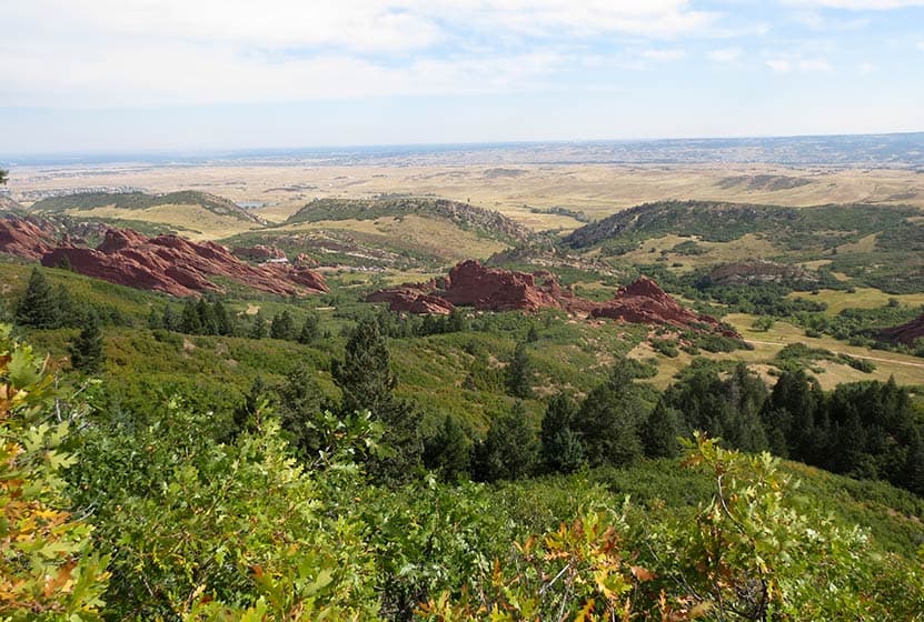
Elk Valley Trail in Roxborough State Park
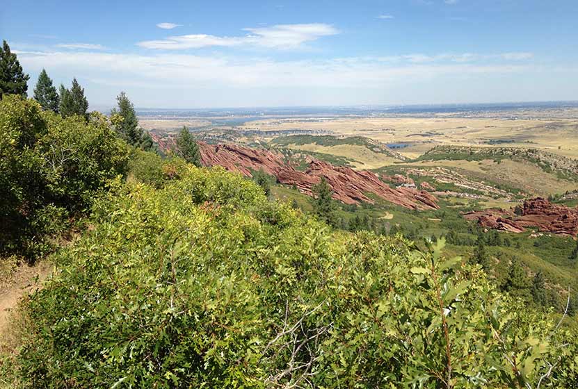
The Elk Valley Trail in Roxborough State Park climbs to a lesser visited valley in the park. Incredible views of the red rock formations of Roxborough make this a great moderate hike near Denver. The hike to Elk Valley is a 4.8 mile out-and-back journey, but can be turned into one of two more strenuous loop hikes. Explore all the details below for trail map, driving directions, trailhead info, and photos of this hike near Littleton, Colorado.
Trail Snapshot: Elk Valley Trail at Roxborough State Park
| Hike Distance | 4.8 Mile with options |
|---|---|
| Difficulty | Moderate |
| Duration | 2-3hrs |
| Trail Type | Out-and-Back with Loop Options |
| Starting Elevation | 6200′ |
| Elevation Gain | +640′ |
| Seasons | Year Round |
| Dogs | Prohibited in the Park |
| Hike Trail Map | Click for a Trail Map |
| Denver Drive Time | 45 min |
| Driving Directions to Roxborough State Park | Click for Google Map |
| Town Nearest Hike | Littleton, Colorado |
| Beauty | Red rock formations, meadows, wildlife: mule deer, eagles, foxes, birds |
| Activities | Hiking, birdwatching, Visitors’ Center |
| Fee | Entrance Fee or State Parks Pass Required |
Roxborough State Park Parking Trailhead Information
Roxborough State Park is located south of Littleton, Colorado, at the base of the foothills near Pike National Forest. The last two miles of access road into Roxborough State Park are a maintained dirt road. This segment of road can get washboarded and can be tough on the car. Undulating green hills can be seen to the east where deer and antelope graze. Roxborough can fill up during the busy weekend hours. If that's the case, you can wait in line at the gatehouse until vehicles and a ranger gives you the signal to drive in. My guess is that the peak times are around 10AM-2PM. If the line looks long, you can always turn around and head over to Waterton Canyon or to South Valley Park--both are great options.
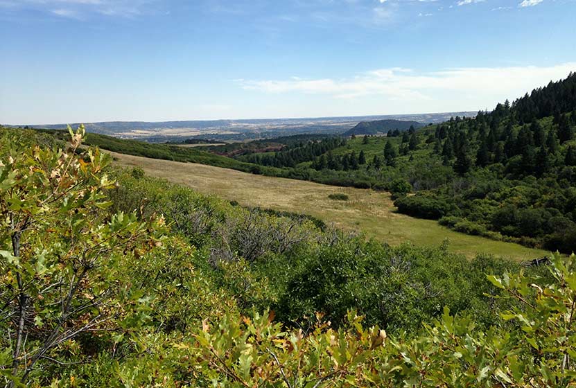
The 2.4 mile, one-way hike up to Elk Valley in Roxborough State Park begins at the main connector trail that runs south from the visitor center. Pictured above, this nearly 1/2 mile connector takes hikers through a passageway created by the scrub oak trees overarching the trail. The undergrowth in this segment of the hike contains a lot of poison ivy. While the poison ivy is off to the side of the trail, it's still easy to brush up against. So, be aware as you make your way through this part of your hike. Also, keep alert for the many birds that make this thicket their home, especially the Western Tanagers that visit in the Spring.
The trail emerges from the shade of the scrub oak into a meadow framed by red rock and yellow cliff bands. A lone cottonwood with a bench stands in the open field of tall grass. One of the great things about Roxborough State Park is the strategic placement of benches, many of them offering shade and wonderful views into the park. At the meadow, the trail will pass through a junction with the South Rim trail and cross a dirt service road. At this point, the trail becomes more demanding, working up a series of switchbacks that lead in and out of the forested sides of the foothills.
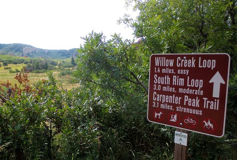
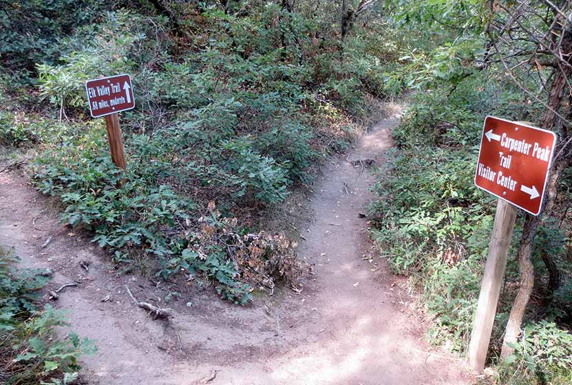
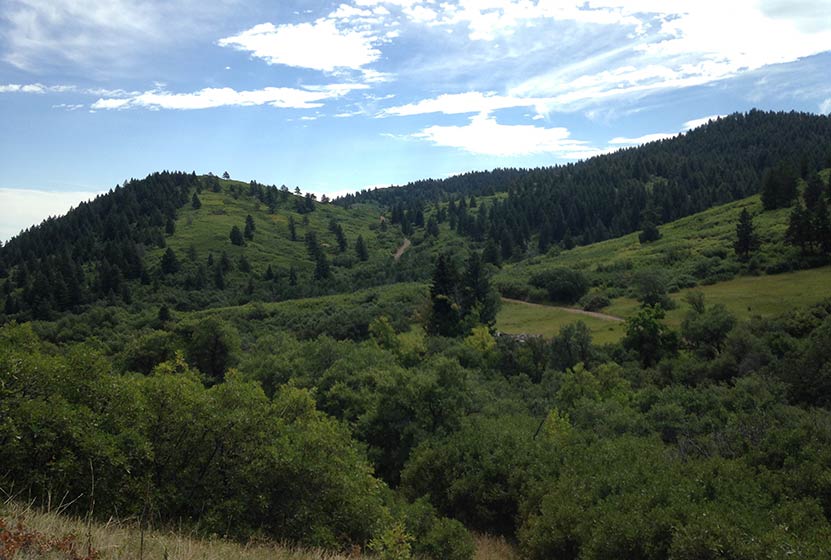
At 1.7 mile into the hike, the trail comes to a Y intersection (pictured below). The trail up the Carpenter Peak takes hikers to the right. The route to Elk Meadows and the Douglas Country Trails beyond it, lead off to the left.
The trail climbs through the forest then opens back to the oaks thickets where, in Autumn you'll hear the continual crunch of of acorns underfoot. Elk Valley comes into view before the trail comes to its end. Another bench sits in the shade of a pine tree and overlooks Elk Valley below. This is a quieter and less visited pat of Roxborough State Park and an ideal spot for viewing wildlife--especially in the early morning or at dusk.
Though the official Elk Valley hike ends at 2.4 miles in, the trail terminates at a junction with a set of Douglas County Trails and USFS trails. These can be used to create two different loop hike options.
Loop Hike Option #1: At the intersection, a 1.75 mile USFS Powerline Trail leads to the right, working its way North where it comes to a junction with the Carpenter Peak Trail. Here hikers can take a right, and hike approximately 1/2 mile to the summit of Carpenter Peak. From the summit, return to the visitor center by following the Carpenter Peak trail back down into the valley floor. This makes for a 7.7 mile strenuous loop hike.
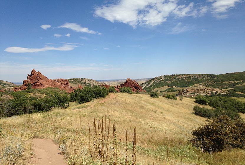
Loop Hike Option #2: At the intersection, a 1.28 stretch of Douglas County Trail leads off to the left. The trail works its way East over a small peak (pictured below), then descends to a junction with the Sharptail and Swallowtail trails. The route back into Roxborough State Park requires taking a left onto a dirt road, Iron Bark Drive. This .88 mile segment (pictured on the trail map) leads northwest back into the heart of the park. Back in the park, hikers can rejoin the trails that lead back to the visitor center. This demanding loop hike totals approximately 5.3 miles.
Tips & Resources for Hiking to Elk Valley in Roxborough
- Packing List: Always pack the 10 Essentials. Download our Hiking Guide to get list and dayhiking packing checklist.
- Dealing with Poison Ivy: You don't have to come into direct contact with poison ivy to get it. Often, it transfers from your clothing to your skin. So be sure to wash your clothing when you get home, if you think you have brushed up against it during your hike in Roxborough.
- Hiking in Winter: If you plan to hike Elk Valley in the winter, it is advised that you have traction devices like YakTrax because much of the trail will be in shadow, and ice will likely form on the trail.
- Trail Map for Roxborough State Park: Trail Map Link
- Colorado Road Conditions: Colorado Road Conditions
- After the Hike: Waterton Tavern in Roxborough
Weather
Map & Driving Directions
Click for Driving Directions

Carpenter Peak Hike in Roxborough State Park
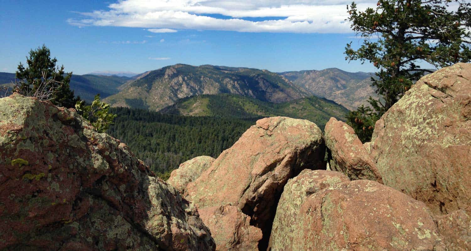
The hike up Carpenter Peak in Roxborough State Park is a strenuous 3.1 mile journey (one-way) to a foothill summit that overlooks the red rock formations of Fountain Valley. You'll also gain 360 degree panoramic views of Denver, east to the plains, and west to distant snow-capped peaks. In this Colorado trail profile, you'll find driving directions, trail map, and more tips and details to help you enjoy this adventure in Roxborough State Park.
Trail Snapshot: Carpenter Peak Hike at Roxborough State Park
| Hike Distance | 6.2 Mile Round Trip |
|---|---|
| Difficulty | Moderate |
| Duration | 3-4 hours |
| Trail Type | Out and Back |
| Starting Elevation | 6200' |
| Elevation Gain | Approx. +960' |
| Seasons | Year Round |
| Dogs | Prohibited in Roxborough State Park |
| Hike Trail Map | Click for a Map of Roxborough State Park |
| Denver Drive Time | 45 min |
| Driving Directions to Roxborough State Park | Click for Google Map |
| Town Nearest Hike | Littleton, Colorado |
| Beauty | Red rock formations, meadows, wildlife: mule deer, eagles, foxes, birds |
| Activities | Hiking, birdwatching, Visitors’ Center |
| Fee | Entrance Fee or State Parks Pass Required |
Parking and Trailhead Information
The last two miles of access road into Roxborough State Park are a maintained dirt road, but it can get washboarded and can be tough on the car. Still, it's not a long drive in. Undulating green hills can be seen in the east where deer and antelope graze. Roxborough State Park can fill up during it's busiest hours on the weekend. If that's the case, you can wait until enough vehicles exit the park then drive in. The peak times appear to be are around 10AM-2PM on the weekends. If the line looks long, you can always turn around and head over to Waterton Canyon or to South Valley Park--both are great options.
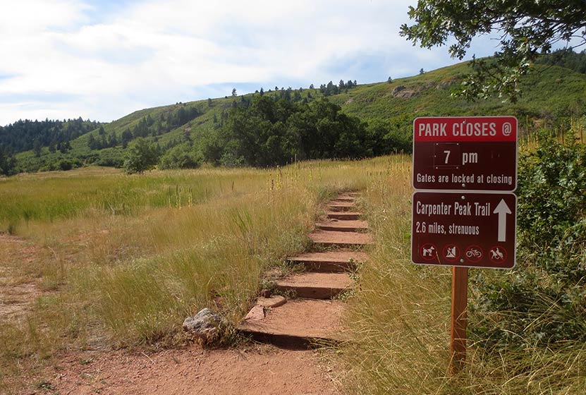
The hike up to Carpenter Peak begins just southwest of the Roxborough State Park visitor center. Clear signage marks this access to Carpenter Peak, the Willow Creek, and South Rim Trails (pictured above). Soon the trail enters a corridor of scrub oak which provides shade for this first short segment of the hike. There is a great deal of poison ivy in this corridor, so be sure to avoid going off trail. Just short of 0.5 mile into the hike, the trail will open up to a large meadow among the red rock. Continue following the signs for Carpenter Peak.
The trail will soon cross a dirt road and begin its way west. This is the most steep and demanding segment of trail. We've classified this as a moderate hike in difficulty, but for those who are from out-of-town or who are not in the best of shape, it may be considered difficult.
At 1.7 mile, the trail will come to a Y intersection (pictured above). The trail to the left leads to Elk Meadows, and the trail for Carpenter Peak leads to the right. The trail now winds along the hillsides with switchbacks that open up to expansive views of the red rock formations that make Roxborough Park Denver's Garden of the Gods.
After gaining the ridge at mile 3, hikers will encounter a final intersection. Again, there is clear signage pointing the way right to Carpenter peak, now just a few hundred yards further. At the summit, you'll be able to take in a 360 degree panorama of Denver, Roxborough State Park, the plains, and distant mountains in the west. I particularly enjoy the views from here over to the mountains that surround Waterton Canyon. In the Spring and early Summer, a few western peaks will still still show their snow caps.
The return route follows the same trails back down to the visitor center.
Tips & Resources for Hiking to Carpenter Peak in Roxborough
- Posion Ivy: Because there is a significant amount of poison ivy that grows out to the edges of parts of this trail, it's wise to wash your clothing soon after your return home as poison ivy can affect people by indirect contact.
- Hiking in Winter: If you plan to hike Carpenter Peak in the winter, it is advised that you have traction devices like YakTrax because much of the trail will be in shadow, and ice will likely form on the trail.
- Trail Map for Roxborough State Park: Trail Map Link
- Packing List: Always pack the 10 Essentials. Download our Hiking Guide to get list and dayhiking packing checklist.
- Colorado Road Conditions: Colorado Road Conditions
- After the Hike: Waterton Tavern in Roxborough
Weather
Map & Driving Directions
Click for Driving Directions

Catamount Falls Hike Near Colorado Springs
The hike to Catamount Falls is a moderate 2.8-mile loop hike about 25 minutes outside of Colorado Springs. This waterfall hike takes hikers to three different waterfalls and over two different creeks that spill down from the heights of Pikes Peak. It makes for a great weekend adventure, coupled with a great opportunity for brunch at the Pantry in Green Mountain Falls. Explore the full Catamount Falls hike profile below for driving directions, trail route description, and more tips and details to help you enjoy this adventure near Colorado Springs.
NOTICE: Catamount Trail access is closed from 8/4/21 to 9/1/21. For Details see Trails and Open Space Coalition Website.
Trail Snapshot: Catamount Falls in Colorado Springs
| Hike Distance | 2.8 miles |
|---|---|
| Difficulty | Moderate |
| Duration | Approx 1-2 hr |
| Trail Type | Loop |
| Starting Elevation | 7720' |
| Elevation Gain | Approx. +560' |
| Seasons | April through October |
| Dogs | Allowed On Leash |
| Denver Drive Time | 1 hr 30 min |
| Driving Directions to Ute Pass Avenue-Lake Street Trailhead | Click for Google Map |
| Town Nearest Hike | Green Mountain Falls, Colorado |
| Beauty | Waterfall, creek, mountain views, wildflowers |
| Activities | Hiking, photography |
Parking & Trailhead Information for Catamount Falls
The hike to Catamount Falls starts at Thomas Trailhead in the quaint mountain village of Green Mountain Falls. However, since there is no parking available at the Thomas trailhead, the hike must be started from the Gazebo Lake parking area in town. To get to Gazebo Lake, from interstate 25, take exit 141 and go west on Cimarron Avenue/US 24 for 13.5 miles to the Chipita Park/Green Mountain Falls exit. Following Green Mountain Falls Rd/Ute Pass Avenue for approximately 0.7 miles. Take a left onto Lake Street. Here you will find the parking area that lines the north side of the small lake.
The Hike: Catamount Falls Trail in Colorado Springs
The loop route below requires two segments along the streets of Green Mountain Falls. The first 0.4 mile segment of the hike will takes hikers from Gazebo Lake to the Thomas Trailhead. Beginning at Gazebo Lake, walk the roadside of Ute Pass Avenue that follows the southern edge of Gazebo Lake. Take a right at the first intersection onto Hotel Street. The streets can be a bit confusing in Green Mountain falls, and Hotel Street will soon turn into Park Avenue. Follow Park avenue as it winds up to its intersection with Boulder Street, a dirt (and sometimes muddy) road that terminates at the Thomas Trailhead.
Once on the Thomas Trail, yellow circle blazes mark the way. The initial stretch of trail leads to the base of the first waterfall on this hike, Crystal Falls @ 0.5 mile. This set of cascades is formed by Crystal Creek as it runs down the mountainside from a Crystal Creek Reservoir, one of the lakes situated above Green Mountain Falls on the flanks of Pikes Peak. A bit further up the trail, there is an observation area for taking in the larger leaps of the falls.
The next 0.7 mile segment of the Thomas Trail leads to the second waterfall, Catamount Falls, and is the more demanding portion of the hike. The trail climbs west/northwest until it arrives at Thomas Trail Memorial. After the memorial, Catamount Falls is just a short ways further up the trail. A spur trail leads from the left/south to the site of Catamount falls.
From Catamount Falls, the next segment of trail goes north to take hikers back into Green Mountain Falls. Yellow blazes mark the way across the creek and back to the Thomas Trail. Soon the trail will encounter an intersection with the Catamount trail at the Catamount Trailhead. Staying on the Thomas Trail, it will cross a small footbridge where a third small waterfall can be viewed. The trail then terminates at Belvedere Avenue.
Here, the final 1-mile segment of this loop hike begins. Taking a right onto paved Belvedere Avenue, it will lead east, back into town. Belvedere Avenue will eventually merge with Ute Pass Avenue. Going South/Right on Ute Pass Avenue then leads back to Gazebo Park.
You may be wondering, "What is a 'catamount?'" A catamount is a mountain lion, also known as a cougar. The Catamount Reservoir and Catamount Creek are both named after this creature that lives in the wilds of Colorado.
Looking for more waterfalls near Denver? Explore our more than 50 Colorado Waterfall Hikes, our favorite Waterfall Hikes in Rocky Mountain National Park, or 7 Waterfalls within One Hour of Denver.
Tips & Resources for Hiking to Catamount Falls in Colorado Springs
- Watch for yellow markers: These will guide you along the Thomas Trail.
- Get there early: This can be a crowded hike on the weekends.
- Parking: Out of respect for the residents of Green Mountain Falls, refrain from parking along the roads near the trailhead. Instead, park at Gazebo Lake and follow the trail description above.
- A Shorter Option: For those looking for a less demanding hike to just one waterfall, follow the route above to take in Crystal Falls only. This makes for a less demanding 1 mile, out-and-back hike.
- Packing List: Always pack the 10 Essentials. Download our Hiking Guide to get the list and dayhiking packing checklist.
- Colorado Road Conditions: Colorado Road Conditions
- Photo: We would like to express our gratitude to Ethan Beute for sharing such an amazing photograph of this hike to Catamount Falls in Colorado Springs.
- After the Hike: The Pantry Restaurant: One of our favorite breakfast places in all of Colorado
Weather
Map & Driving Directions
Click for Driving Directions


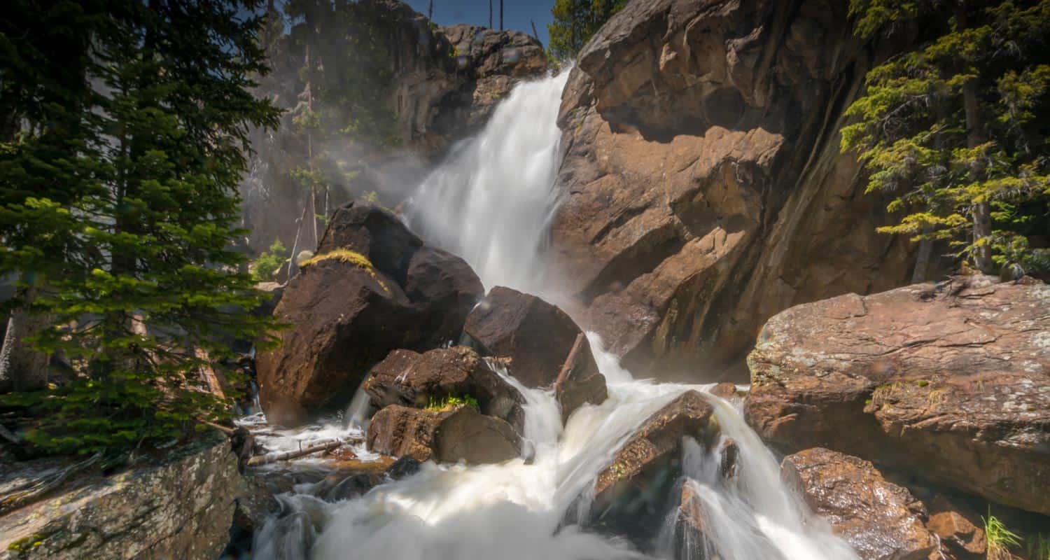
Granite Falls in Rocky Mountain National Park
Granite Falls takes a 5.1 mile journey from the Green Mountain Trailhead in Rocky Mountain National Park. At Granite Falls, the waters of Tonahutu Creek drop fifty feet through a course of smooth granite slabs. The hike offers a diverse landscape: from tranquil forests, to expansive meadows, and verdant creeksides--all alive with wildflowers and wildlife. Explore the full Granite Falls hike profile below for trail map, driving directions, and more tips and details to help you enjoy this adventure in Rocky Mountain National Park.
Note: Rocky Mountain National Park now requires timed entry permits from May 27th through October 10th. See the RMNP permits page for more information.
Trail Snapshot: Granite Falls Hike in Rocky Mountain National Park
| Hike Distance | 10.2 miles Round Trip |
|---|---|
| Difficulty | Moderate |
| Duration | Approx 5 to 7 hr Round Trip |
| Trail Type | Out and Back |
| Starting Elevation | 8800' |
| Elevation Gain | Approx. +940' |
| Seasons | Spring through Fall |
| Dogs | Prohibited in RMNP |
| Hike Trail Map | Click for a Map of Granite Falls RMNP |
| Denver Drive Time | 2 hr |
| Driving Directions to Green Mountain Trailhead | Click for Google Map |
| Town Nearest Hike | Grand Lake, Colorado |
| Beauty | Waterfall, pine, aspen, mountain views, wildlife: Abert’s squirrel, elk, deer, moose, bear; wildflowers |
| Activities | Picnicking, hiking trails, snowshoeing, horseback riding, backcountry camping (with a permit), photography |
| Fee | Park Pass Required |
Parking & Trailhead Information for Granite Falls
The Green Mountain Trailhead is located on the western side area of Rocky Mountain National Park, north of Grand Lake, Colorado, along Trail Ridge Road. From the Kawuneeche Visitor Center in Grand Lake, drive 3 miles north on Trail Ridge Road. The Green Mountain Trailhead will be on the right/east side of the road, and has a capacity for around 25 vehicles.
The Hike: Granite Falls Trail in RMNP
The hike begins at the Green Mountain Trailhead and follows the Green Mountain Trail for 1.9 miles to Big Meadows, and encounters the first trail junction. The way to Granite Falls is to take the left-hand trail for 0.7 mile that skirts the western border of Big Meadows. There is a group campsite in Big Meadows that offers some of the most spectacular views of the night sky. Moose and elk frequent this area and brook trout can be found in nearby Tonahutu Creek.
At 2.6 miles, the trail meets a second trail junction. The way to Granite Falls is to go right/east on the Tonahutu trail towards Flattop Mountain. Because their is only a 1000' elevation gain over the course of the 5.1 miles to Granite Falls, the trail only has a mild and undulating slope. After crossing two creeks, a small sign will point the way down a spur trail that leads to Granite Falls. The waterfall is a series of slide cascades flowing over broad granite slabs into a pool of swirling waters. The hike back follows the same route, making this a 10.2 mile out-and-back hike.

Tips & Resources for Hiking to Granite Falls in RMNP
- Prepare: Bring lots of water and high-energy food for this longer 10.2 mile hike.
- Trail Map for Kawuneeche Valley: Trail Map Link
- Packing List: Always pack the 10 Essentials. Download our Hiking Guide to get list and dayhiking packing checklist.
- Colorado Road Conditions: Colorado Road Conditions
- Photo: We would like to express our gratitude to Will Currier for sharing such an amazing photograph of this hike to Granite Falls in RMNP.
- After the Hike: Fat Cat Cafe It may be the best breakfast in Colorado!
Weather
Map & Driving Directions
Click for Driving Directions

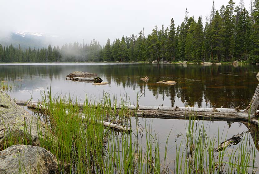
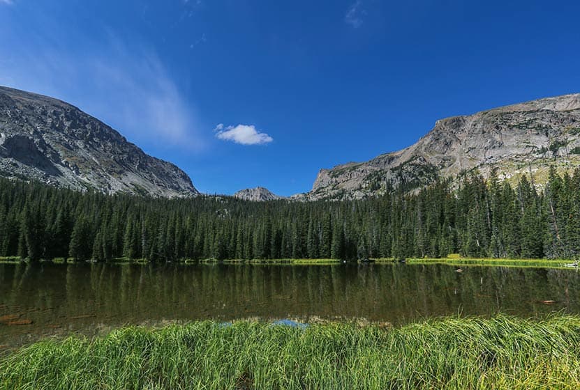
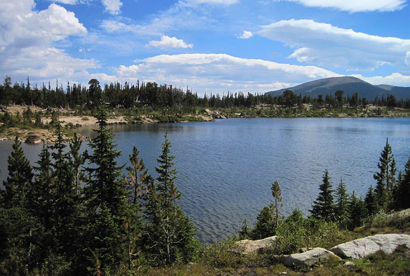
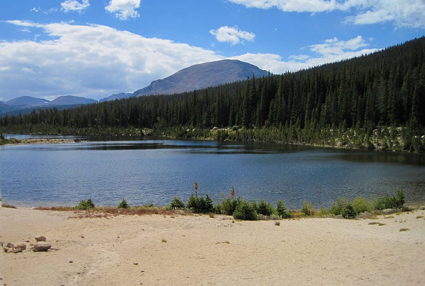
Finch Lake Hike in Rocky Mountain National Park
Finch Lake is a 4.5 mile hike through pines, aspen glades, and wildflower laden meadows to a sub-alpine lake where the forest surrounds its shores. The Finch Lake trail is a great choice for those who prefer solitude as it's one of the lesser traveled trails in the Wild Basin region of RMNP. Explore the full Finch Lake hike profile below for trail map, driving directions, and more tips and details to help you enjoy this adventure in Rocky Mountain National Park.
Note: Rocky Mountain National Park now requires timed entry permits from May 27th through October 10th. See the RMNP permits page for more information.
Trail Snapshot: Finch Lake in Rocky Mountain National Park
| Hike Distance | 9 miles Round Trip |
|---|---|
| Difficulty | Moderate |
| Duration | Approx 5-6 hr Round Trip |
| Trail Type | Out and Back |
| Starting Elevation | 8470' |
| Elevation Gain | Approx. +1442' |
| Seasons | Spring through Fall |
| Dogs | Prohibited in RMNP |
| Hike Trail Map | Click for a Map of Finch Lake RMNP |
| Denver Drive Time | 1 hr 30 min |
| Driving Directions to Finch Lake Trailhead | Click for Google Map |
| Town Nearest Hike | Allenspark, Colorado |
| Beauty | Waterfall, mountain views, meadows, aspen, river, wildlife: blue dragonfly, jackrabbit, mallard, Abert’s squirrel, elk, deer, moose, bear; wildflowers |
| Activities | Picnicking, hiking trails, snowshoeing, horseback riding, backcountry camping (with a permit), photography |
| Fee | Park Pass Required |
Parking & Trailhead Information for Finch Lake
The Finch Lake Trailhead is located approximately 1/5th of a mile east of the larger Wild Basin Trailhead near Allenspark, Colorado. Because there is very limited parking at the Finch Lake Trailhead, most hikers will need to park at the Wild Basin Trailhead and add the 1000' feet of trail between the Wild Basin Trailhead and the Finch Lake Trailhead to their journey. There is an alternative approach via the Allenspark Trailhead. However, the route described in this trail profile will be from the Finch Lake Trailhead nearest to the Wild Basin Trailhead.
- Map and Driving Directions to the Finch Lake Trailhead
- Map and Driving Directions to the Wild Basin Trailhead
The Hike: Finch Lake Trail in RMNP
The hike up to the Lake is a steady climb through a forest of pine, aspen, spruce, and meadows laden with wildflowers. It begins with a set of switchbacks then follows the contours of a moraine. After gaining the ridge of the moraine, the trail begins a gentle descent through one of Rocky Mountain National Park's most stunning displays of wildflowers. Near the bottom of the moraine, just above Fox Creek, the trail will come to its first junction. The the trail to the right/west leads towards both the lake (the left/east trail leads to the Allenspark Trailhead). Climbing higher, the trail will pass an overlook with views of the distant mountain peaks and the greater Wild Basin area.
The next trail junction--at approx. 2.5 miles--has been named "Confusion Junction" because of its power to confound hikers. Pause and study the trail signage in order to choose the correct trail. The correct way is the trail labeled "Pear Lake" and/or "Finch Lake."
After approximately 1/4 mile, the trail works its way through a burn area from a 1978 fire, now in full recovery mode and blanketed with summer wildflowers. Continuing to work uphill, the trail makes several stream crossings before a descent to the lake, which begins at 3.8 miles. Then, at approximately 4.25 miles, the trail makes a hard right-turn. This part of the trail is often obscured by snow as late as as midsummer and early as the first signs of autumn.
At the Lake the trail wraps around the eastern edge, then the northern shore of the lake. During midsummer, swarms of bright blue dragonflies dance along its waters. The Finch Lake backcountry camping sites are located on the north and northwestern side. These backcountry camping sites can be reserved through the RMNP Backcountry Offices.
Finch Lake is not a good fishing destination. However, Pear Lake, just 2 miles further up the trail, is a much better destination for anglers and offers spectacular views of the rugged peaks surrounding it.
Finch Lake - Another View
Tips & Resources for Hiking to Finch Lake in RMNP
- Prepare: It's a long and demanding hike, so bring lots of water and high-energy food.
- Packing List: Always pack the 10 Essentials. Download our Hiking Guide to get list and dayhiking packing checklist.
- Get there early: Parking lot might get full even early in the morning. Hikers should expect to have to park at the Wild Basin Trailhead and add approximately 1/2 mile to their round trip hike (1000' one-way to the Finch Lake Trailhead).
- You’re in Bear Country: Black Bears live in the Wild Basin area and are active on the months of April through November. Be aware, dispose of your food responsibly, and don’t food or anything else with a strong scent in your vehicle.
- Trail Map for Wild Basin Area: Trail Map Link
- Colorado Road Conditions: Colorado Road Conditions
- Photo: We would like to express our gratitude to Shea Oliver for sharing such amazing photographs of this hike.
- After the Hike: Rock Creek Tavern & Pizzeria
Weather
Map & Driving Directions
Click for Driving Directions
Lyric Falls Hike in Rocky Mountain National Park
Lyric Falls is a beautiful stair-step waterfall that spills over the moss-covered granite slabs of Hunters Creek in Rocky Mountain National Park. A lesser-known waterfall, Lyric Falls requires a 3/4 mile segment on the unmaintained social trail that winds along Hunters Creek. Locating the falls may be a bit challenging and land navigation skills are needed for this hike in the Wild Basin area of RMNP. Explore the full Lyric Falls hike profile below for trail map, driving directions, and more tips and details to help you enjoy this adventure in Rocky Mountain National Park.
Note: Rocky Mountain National Park now requires timed entry permits from May 27th through October 10th. See the RMNP permits page for more information.
| Hike Distance | Approx 8 miles Round Trip |
|---|---|
| Difficulty | Moderate |
| Duration | 6-8 hr Round Trip |
| Trail Type | Out and Back |
| Starting Elevation | 8430' |
| Elevation Gain | Approx. +1730' |
| Seasons | Spring through Fall |
| Dogs | Prohibited in RMNP |
| Hike Trail Map | Click for a Map of Wild Basin Area |
| Trails Illustrated Map | Recommended Topo Map Noting Location of Lyric Falls |
| Denver Drive Time | 1 hr 30 min |
| Driving Directions to Sandbeach Lake Trailhead | Click for Google Map |
| Town Nearest Hike | Allenspark, Colorado |
| Beauty | Mountain views, aspen, ponderosa, limber pine, creek, wildlife: Abert’s squirrel, elk, deer, moose, bear; wildflowers |
| Activities | Picnicking, hiking trails, winter snowshoeing, horseback riding, backcountry camping (with a permit), photography |
| Fee | Park Pass Required |
Parking & Trailhead Information for Lyric Falls
The Sandbeach Lake Trailhead is located off of County Road 84 near, just about 1/2 mile west from its junction with Highway 7. See the driving directions link above for the detailed route. The trailhead is across the street from the Wild Basin Lodge and Event Center. The trailhead has toilet facilities and parking capacity of about 25 cars (includes gravel side-lot).
The Hike: Lyric Falls Trail in RMNP
The first segment of the hike to Lyric Falls follows the Sandbeach Lake Trail for approximately 3.2 miles to the footbridge crossing Hunter's Creek. An indistinct social trail is located near the bridge on the east side of Hunter's creek. This second trail segment is 3/4 of a mile is unmaintained, which means that hikers should have a sufficient level of land navigation skills (map reading and proficiency with a compass/gps unit) to negotiate the terrain to Lyric Falls.
This .75 mile section follows the course of Hunter's Creek Northwest and uphill to the location of Lyric Falls. There is no marker for Lyric Falls, but it can be located on the National Geographic Trails Illustrated Map of Rocky Mountain National Park. Hikers will likely hear several smaller cascades along the way. In the same way, the cascades of Lyric Falls will be heard before seen, and the sounds of its splash and spray will be the best way to locate the falls.
A meadow bright with wildflowers can be found just bit further up Hunter's Creek beyond Lyric Falls.
Campsites Along the Lyric Falls Trail
Stay overnight and explore the larger Hunter's Creek Drainage. There are several Backcountry Camping sites along the Sandbeach Lake Trail: Hole-in-the-Wall, Campers Creek, Beaver Mill, and Sandbeach Lake. These backcountry camping sites can be reserved through the RMNP Backcountry Offices. Staying overnight, hikers can then explore Lyric Falls, Sandbeach Lake, and this lesser hiked area of the Wild Basin in Rocky Mountain National Park.
Tips & Resources for Hiking to Lyric Falls in RMNP
- Packing List: Always pack the 10 Essentials. Download our Hiking Guide to get list and dayhiking packing checklist.
- Recommended Trail Map: We recommend the National Geographic Trails Illustrated Map which indicates the location of the Backcountry Camping Sites, and provides topo information, too.
- Get there early: Parking is limited. Arrive early to secure a parking spot at the trailhead.
- You’re in Bear Country: Black Bears live in the Wild Basin area and are active on the months of April through November. Be aware, dispose of your food responsibly, and don’t food or anything else with a strong scent in your vehicle.
- Colorado Road Conditions: Colorado Road Conditions
- Photo: We would like to express our gratitude to Thomas Mangan for sharing such great photos of this hike to Lyric Falls in RMNP. Tom leads photography tours in Rocky Mountain National Park. Check out his site thomasmagan.com for details.
- After the Hike: Meadow Mountain Cafe in Allenspark, Colorado
Weather
Map & Driving Directions
Click for Driving Directions
Ouzel Lake Hike in Rocky Mountain National Park
Ouzel Lake is nestled in an expansive valley in the Wild Basin, and is one of the better fishing destinations in Rocky Mountain National Park. It's a moderate, 4.9 mile, creekside hike that passes several beautiful cascade waterfalls, including one of our favorites, Ouzel Falls. Combine the hike to Ouzel Lake with an overnight, and a journey to the shores Bluebird Lake. Explore the full Ouzel Lake hike profile below for trail map, driving directions, and more tips and details to help you enjoy this adventure in Rocky Mountain National Park.
Note: Rocky Mountain National Park now requires timed entry permits from May 27th through October 10th. See the RMNP permits page for more information.
Trail Snapshot: Ouzel Lake in Rocky Mountain National Park
| Hike Distance | 9.8 miles Round Trip |
|---|---|
| Difficulty | Moderate |
| Duration | Approx 5-7 hr Round Trip |
| Trail Type | Out and Back |
| Starting Elevation | 8566' |
| Elevation Gain | Approx +1510' |
| Seasons | Spring through Fall |
| Dogs | Prohibited in RMNP |
| Hike Trail Map | Click for a Map of Ouzel Lake RMNP |
| Denver Drive Time | 1 hr 30 min |
| Driving Directions to Wild Basin Trailhead | Click for Google Map |
| Driving Directions to Winter Recreation Parking for Wild Basin Hikes | Click for Google Map |
| Town Nearest Hike | Allenspark, Colorado |
| Beauty | Lake, alpine tundra, waterfall, mountain views, meadows, river, wildlife: Abert's squirrel, elk, deer, moose, bear; wildflowers |
| Activities | Fly fishing, picnicking, hiking trails, snowshoeing, horseback riding, backcountry camping (with a permit), photography |
| Fee | Park Pass Required |
Parking & Trailhead Information for Ouzel Lake
The southeast corner of Rocky Mountain National Park boasts one of the loveliest portions in the park known as the Wild Basin. The Wild Basin Trailhead is located just 15 minutes outside of Allenspark, Colorado along Highway 115. There is a ranger station at at the Wild Basin Trailhead with toilets and drinking water available.
In the winter (October-May), Hwy 115 may not be plowed to the trailhead, and hikers will need to park their vehicles at a winter parking lot for Wild Basin hikes. Be aware that hikes from the winter parking lot add on another 3 miles of hiking (one-way). There are other small parking areas, like the Finch Lake Trailhead, that may be accessible and allow hikers to park closer to the Wild Basin Trailhead. It's important to know that Hwy 115, though titled a "highway", is a maintained dirt road, which means that it can be used by 2WD vehicles. However, after heavy rains and other severe weather, its quality may degrade until it is repaired. 4WD may be needed when snow is on the ground.
The Hike: Ouzel Lake Trail in RMNP
It's 4.9 miles one-way to Ouzel Lake. The trail begins at the Wild Basin Trailhead, and takes hikers through the central area of the Wild Basin, past three cascade waterfalls: Copeland Falls, Calypso Cascades, and Ouzel Falls.
The first waterfall, Copeland Falls, is just 0.4 mile into the hike on this first, easy segment of trail. For details on accessing both the lower and upper leaps of Copeland Falls, check out our full trail profile for Copeland Falls.
The path follows North Saint Vrain Creek until it encounters a first trail junction. The trail to the right leads past a series of backcountry campsites. These are reservable through the Rocky Mountain National Park Wilderness offices and make for a great place to stay for longer adventures into the Wild Basin area. The left-hand trail is the correct way towards the Bluebird Lake trail system and Ouzel Lake.
Having taken the left-hand trail, hikers cross a large log bridge spanning North St. Vrain Creek. Pause when you hear the sounds of an unnamed cascade that can be viewed from the bridge area. Soon after the bridge, the trail meets with a second trail junction at Calypso Cascades. Taking the right-hand trail, the cascades (named after the purple orchids that grow along the creek) come into view. The path crosses a second bridge at 1.8 miles, then things begin to get more challenging, as the trail weaves through a set of switchbacks to Ouzel Falls at 2.7 miles.
Ouzel Falls on a Wet Spring Day - Courtesy of Chris Heald
After about 0.4 mile past Ouzel Falls, the trail comes to a junction with the Bluebird Lake trail, 3.1 miles into the hike. The way to Ouzel Lake takes the Bluebird Trail (left). This final 1.8 segment of the hike to Ouzel Lake gains a ridgeline and becomes more demanding. It's a desolate segment of trail, charred by a fire in 1978. However, wildflowers make their way up through the barren landscape, and the surrounding mountain peaks come into full view due to the few trees left by the burn.
At 4.5 miles, there is a marked trail spur that leads to Ouzel Lake, bending its way around a small pond to Ouzel's northwestern shore. At the lake, you'll find more trees and a lot of marshland--and marsh = mosquitos, so be sure to bring repellant. If you are looking to try some deet-free repellant, we have had some great luck with a lemon-ecualyptus repellant made by repel. The fishing up at Ouzel Lake is great! Of course, a Colorado State fishing license is required.
Tips & Resources for Hiking to Ouzel Lake in RMNP
- Camp + Hike + Fish: Reserve one of the two backcountry camping sites along the Bluebird Trail to spend some time fishing Ouzel Lake and exploring the other destinations along the trail: Bluebird Lake, a waterfall between them, Lark Pond, and Pipit Lake. Contact the RMNP Wilderness Offices to reserve a site.
- Summer Thunderstorms: If you see clouds with dark undersides building in the west, this means that thunderstorms are likely--a typical occurrence on most summer days. Begin hikes early to avoid storms and consider turning back if weather looks threatening.
- Get there early: Parking may be somewhat limited as with many hikes in RMNP area and can get full even early in the morning.
- You're in Bear Country: Black Bears live in the Wild Basin area and are active on the months of April through November. Be aware, and dispose of your food responsibly.
- Trail Map for Wild Basin Area: Trail Map Link
- Packing List: Always pack the 10 Essentials. Download our Hiking Guide to get list and dayhiking packing checklist.
- Food Storage: There are food storage lockers available at the Wild Basin, Finch Lake, and Sandbeach Lake Trailheads. These are required for visitors staying overnight. Backcountry campers are required to use bear resistant food containers.
- Colorado Road Conditions: Colorado Road Conditions
- Photo: We would like to express our gratitude to Ed Ogle for sharing such an amazing photograph of this hike to Ouzel Lake in RMNP.
- After the Hike: Meadow Mountain Cafe
Weather
Map & Driving Directions
Click for Driving Directions
Sandbeach Lake Hike in Rocky Mountain National Park
Sandbeach Lake features great fishing and a beach! The lake got its name from its sandy shore that resembles that of a beach--making it one of best camping spots in Rocky Mountain National Park. It's a 4.5 mile moderate hike that climbs Copeland Moraine and crosses two creeks before arriving at this beautiful subalpine lake. With several reservable campsites along the way, Sandbeach Lake makes for a great initial multi-day backpacking trip for young families. Explore the full Sandbeach Lake hike profile below for trail map, driving directions, and more tips and details to help you enjoy this adventure in Rocky Mountain National Park.
Note: Rocky Mountain National Park now requires timed entry permits from May 27th through October 10th. See the RMNP permits page for more information.
Trail Snapshot: Sandbeach Lake in Rocky Mountain National Park
| Hike Distance | 8.4 miles Round Trip |
|---|---|
| Difficulty | Moderate |
| Duration | Approx 6 hr Round Trip |
| Trail Type | Out and Back |
| Starting Elevation | 8430′ |
| Elevation Gain | Approx +1971′ |
| Seasons | Spring through Fall, Winter Snowshoeing |
| Dogs | Prohibited in RMNP |
| Hike Trail Map | Click for a Map of Sandbeach Lake RMNP |
| Denver Drive Time | 1 hr 30 min |
| Driving Directions to Sandbeach Lake Trailhead | Click for Google Map |
| Town Nearest Hike | Allenspark, Colorado |
| Beauty | Lake, mountain views, aspen, ponderosa, limber pine, creek, wildlife: Abert’s squirrel, elk, deer, moose, bear; wildflowers |
| Activities | Picnicking, hiking trails, fishing, snowshoeing, horseback riding, backcountry camping (with a permit), photography |
| Fee | Park Pass Required |
Parking & Trailhead Information for Sandbeach Lake
The Sandbeach Lake Trailhead is located off of County Road 84 near, just about 1/2 mile west from its junction with Highway 7. See the driving directions link above for the detailed route. The trailhead is across the street from the Wild Basin Lodge and Event Center. The trailhead has toilet facilities and parking capacity of about 25 cars (includes gravel side-lot).
The Hike: Sandbeach Lake Trail in RMNP
The 4.5 mile hike (one-way) to Sandbeach Lake first heads north out of the Sandbeach Lake Trailhead, then begins a moderate climb to gain the ridge of the Copeland Moraine. The trail then follows the ridgeline west until it crosses Campers Creek at 2.3 miles. Here, the trail makes a short, but sharp, bend to the the south before continuing west/northwest. At 3.3 miles, the trail crosses a second creek, Hunters Creek, then makes a steady climb to the northern shores of Sandbeach Lake.
Campsites Along the Sandbeach Lake Trail
There are several backcountry campsites along the Sandbeach Lake Trail, making the hike up to Sandbeach Lake, a great opportunity for young families and first-time backpackers who want to do their first multi-day trip. Camping permits must be obtained through the RMNP Wilderness offices. A basic itinerary would be to drive into the park's Wilderness Office in the late morning, grab lunch, then hike to one of the campsites listed below. For a two-night trip, families could elect to camp at one of the earlier campsites: Hole in the Wall or Campers Creek. Then, day two would be a short hike up to Sandbeach Lake, a perfect place for a second night under an expanse of stars. Day three would consist of a 4.5 mile hike out to the trailhead. Be sure to call ahead to the Wilderness Office to book your sites.
Tips & Resources for Hiking to Sandbeach Lake in RMNP
- Packing List: Always pack the 10 Essentials. Download our Hiking Guide to get list and dayhiking packing checklist.
- Recommended Trail Map: We recommend the National Geographic Trails Illustrated Map which indicates the location of the Backcountry Camping Sites, and provides topo information, too.
- Get there early: Parking is limited. Arrive early to secure a parking spot at the trailhead.
- You’re in Bear Country: Black Bears live in the Wild Basin area and are active on the months of April through November. Be aware, dispose of your food responsibly, and don’t food or anything else with a strong scent in your vehicle.
- Trail Map for Wild Basin Area: Trail Map Link
- Colorado Road Conditions: Colorado Road Conditions
- Photo: We would like to express our gratitude to Reese Lloyd for sharing such great photos of this hike to Sandbeach Lake in RMNP.
- After the Hike: Meadow Mountain Cafe in Allenspark, Colorado
Weather
Map & Driving Directions
Click for Driving Directions