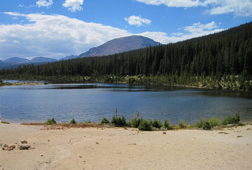
Sandbeach Lake features great fishing and a beach! The lake got its name from its sandy shore that resembles that of a beach–making it one of best camping spots in Rocky Mountain National Park. It’s a 4.5 mile moderate hike that climbs Copeland Moraine and crosses two creeks before arriving at this beautiful subalpine lake. With several reservable campsites along the way, Sandbeach Lake makes for a great initial multi-day backpacking trip for young families. Explore the full Sandbeach Lake hike profile below for trail map, driving directions, and more tips and details to help you enjoy this adventure in Rocky Mountain National Park.
Note: Rocky Mountain National Park now requires timed entry permits from May 27th through October 10th. See the RMNP permits page for more information.
Trail Snapshot: Sandbeach Lake in Rocky Mountain National Park
| Hike Distance | 8.4 miles Round Trip |
|---|---|
| Difficulty | Moderate |
| Duration | Approx 6 hr Round Trip |
| Trail Type | Out and Back |
| Starting Elevation | 8430′ |
| Elevation Gain | Approx +1971′ |
| Seasons | Spring through Fall, Winter Snowshoeing |
| Dogs | Prohibited in RMNP |
| Hike Trail Map | Click for a Map of Sandbeach Lake RMNP |
| Denver Drive Time | 1 hr 30 min |
| Driving Directions to Sandbeach Lake Trailhead | Click for Google Map |
| Town Nearest Hike | Allenspark, Colorado |
| Beauty | Lake, mountain views, aspen, ponderosa, limber pine, creek, wildlife: Abert’s squirrel, elk, deer, moose, bear; wildflowers |
| Activities | Picnicking, hiking trails, fishing, snowshoeing, horseback riding, backcountry camping (with a permit), photography |
| Fee | Park Pass Required |
Parking & Trailhead Information for Sandbeach Lake
The Sandbeach Lake Trailhead is located off of County Road 84 near, just about 1/2 mile west from its junction with Highway 7. See the driving directions link above for the detailed route. The trailhead is across the street from the Wild Basin Lodge and Event Center. The trailhead has toilet facilities and parking capacity of about 25 cars (includes gravel side-lot).
The Hike: Sandbeach Lake Trail in RMNP
The 4.5 mile hike (one-way) to Sandbeach Lake first heads north out of the Sandbeach Lake Trailhead, then begins a moderate climb to gain the ridge of the Copeland Moraine. The trail then follows the ridgeline west until it crosses Campers Creek at 2.3 miles. Here, the trail makes a short, but sharp, bend to the the south before continuing west/northwest. At 3.3 miles, the trail crosses a second creek, Hunters Creek, then makes a steady climb to the northern shores of Sandbeach Lake.
Campsites Along the Sandbeach Lake Trail
There are several backcountry campsites along the Sandbeach Lake Trail, making the hike up to Sandbeach Lake, a great opportunity for young families and first-time backpackers who want to do their first multi-day trip. Camping permits must be obtained through the RMNP Wilderness offices. A basic itinerary would be to drive into the park’s Wilderness Office in the late morning, grab lunch, then hike to one of the campsites listed below. For a two-night trip, families could elect to camp at one of the earlier campsites: Hole in the Wall or Campers Creek. Then, day two would be a short hike up to Sandbeach Lake, a perfect place for a second night under an expanse of stars. Day three would consist of a 4.5 mile hike out to the trailhead. Be sure to call ahead to the Wilderness Office to book your sites.
Tips & Resources for Hiking to Sandbeach Lake in RMNP
- Packing List: Always pack the 10 Essentials. Download our Hiking Guide to get list and dayhiking packing checklist.
- Recommended Trail Map: We recommend the National Geographic Trails Illustrated Map which indicates the location of the Backcountry Camping Sites, and provides topo information, too.
- Get there early: Parking is limited. Arrive early to secure a parking spot at the trailhead.
- You’re in Bear Country: Black Bears live in the Wild Basin area and are active on the months of April through November. Be aware, dispose of your food responsibly, and don’t food or anything else with a strong scent in your vehicle.
- Trail Map for Wild Basin Area: Trail Map Link
- Colorado Road Conditions: Colorado Road Conditions
- Photo: We would like to express our gratitude to Reese Lloyd for sharing such great photos of this hike to Sandbeach Lake in RMNP.
- After the Hike: Meadow Mountain Cafe in Allenspark, Colorado

Weather
Map & Driving Directions
Click for Driving Directions


