Looking for the best hikes near Boulder, Colorado? Boulder is just just 30 miles northwest of Denver, Colorado. Nestled right up against the foothills, it has many hiking trails that begin right in town. Hiking near Boulder can take you along Boulder Creek, into the beautiful flatirons, or deep into the Indian Peaks Wilderness Area. It’s Colorado hiking at its best! Come back to explore the new Colorado hike profiles we add to our archives. When you click on each of the trails featured in this set you’ll get driving directions, links to maps, and great tips for making the most of your outdoor adventure in Boulder.

Chautauqua Loop Trail in Boulder
The Chautauqua Trail is an easy 3.6 mile loop hike along Boulder's Flatirons. The trails pass several historical sites: a quarry, cabin, shelter, and ski area as it weaves through the meadows and ponderosa forest of Chautauqua Park. About 40 minutes from Denver, the Chautauqua Loop hike makes for a great hike for visitors who are looking for stunning landscapes ...
Chautauqua Park Hikes in Boulder
Chautauqua Park in Boulder Colorado is the Trailhead for 40 miles of hiking trails, including hikes into the Flatirons, paths through canyons, and trails to summits with views to the Rocky Mountains in the west. Explore all of these iconic hikes located right in the city of Boulder. Chautauqua Park Trails Snapshot Hike Distance 40 Miles of Trails Difficulty Easy ...
Mallory Cave Hike in Boulder
Mallory Cave is a 1.4-mile, moderate hike up into red rock formations of the Boulder Flatirons to a gated cave. Just 40 minutes from Denver, the trail to Mallory Cave was one of the earliest established recreational trails along the Front Range of Colorado. Explore the full trail profile for trail map, driving direcitons, photos, and tips for his hike ...
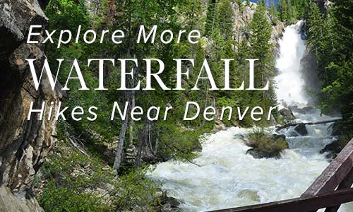
10 Best Hikes Near Boulder Colorado
Where are the best hiking trails close to Boulder? We've been hiking in and around Boulder, Colorado for years, profiling over 30 different trails. So, we decided to share here our favorite hikes near Boulder. These ten hikes will give you a variety of landscapes and experiences. You'll find dog friendly hikes, hikes to summits, and waterfalls. And we'll update ...
Mesa Trail to Bear Canyon Creek
The Mesa Trail south of Boulder, Colorado, rambles across wild open country at the base of the iconic Flatirons. Hike a 4.1 mile loop or an 8.4 mile out-and-back option through pine woods, verdant creek draws, and flowering meadows. Explore the full Mesa Trail profile for this southern segment of one of our favorite dog-friendly hikes near Denver. Trail Snapshot: ...
South Boulder Peak
South Boulder Peak is a demanding 3.7-mile hike (one-way) situated above the South Mesa in the famous Flatirons region near Boulder Colorado. Hikers can bag nearby Bear Peak on the same trip and return via Fern Canyon to make an 8.7 mile loop. Explore the full South Bolder Peak hike profile below for the trail map, driving directions, and more ...
Bear Peak Near Boulder
Bear Peak is a demanding 7.4-mile hike (round trip) through the broad meadows of South Mesa, up through the rocky trail of shadow canyon, to the granite summit with sweeping 360 degree views of the Colorado Front Range. Hikers can summit South Boulder Peak on your way and make a loop hike out of your adventure by returning via Fern ...
Jasper Lake Hike in Indian Peaks
Jasper Lake requires a 5.5-mile (one-way) hike into the mountainous, wildflower-laden Indian Peaks Wilderness. Just 40 minutes outside of Boulder Colorado and about 1hr 15 minutes from Denver, the trail to Jasper Lake gets its start at the Hessie Trailhead. Travel an additional mile beyond Jasper to see Devils Thumb, a striking rock formation that looms above Devil's Thumb Lake ...
Long Lake Loop in Indian Peaks
Long Lake offers an easy 1.5 mile loop hike in Indian Peaks Wilderness. Located about 1 hour West of Boulder, Colorado, Long Lake is an easy-to-access alpine lake with stunning scenery. It's a popular spot, especially in the Summer months, so be sure to read the details on access fees and the notes below on the Long Lake Trailhead. Explore ...
Devils Thumb Lake
Devils Thumb Lake is located in Indian Peaks Wilderness north of Boulder Colorado and can be accessed via a 6.5-mile (one-way) steep and challenging hike. Wildflowers, alpine meadows, small waterfalls, and cascades all beckon those who have the stamina to explore these heights in the Front Range near Denver. Explore the full Devils Thumb Lake hike profile below for trail ...
Lost Lake Hike Near Nederland
Lost Lake is an accessible 4-mile round-trip hike to a beautiful alpine lake surrounded by the mountains of Indian Peaks. Just over one hour northwest of Denver, the trail up to lost lake takes you along the course of Middle Boulder Creek, a slide waterfall, a set of tumbling cascades, and a variety of wildflowers that decorate the borders of ...
Shanahan Ridge Hike Near Boulder
The Shanahan Ridge Loop Hike is an easy, 4-mile lollipop-loop trail with stunning views of the Shanahan Ridge of the Flatirons in Boulder, Colorado. Explore the full Shanahan Ridge Loop hike profile below for trail map, driving directions, and more tips and details to help you enjoy this hike in Boulder. Trail Snapshot: Shanahan Ridge Loop Trail in Boulder, Colorado ...
St. Vrain Mountain Hike
The St. Vrain Mountain trail is just a 3-mile hike into Indian Peaks Wilderness to stunning views of the rocky peaks of Wild Basin. Hike up and additional 1.5 miles from the RMNP boundary to the summit of St. Vrain mountain for 360-degree panoramic views of a wildflower-laden wilderness. Explore the full St. Vrain Mountain hike profile below for trail ...
Bear Canyon Loop Hike at NCAR
The Bear Canyon Loop Hike near Boulder, Colorado is a beautiful trail that spans wide open spaces and meadows near National Center for Atmospheric Research. The Bear Canyon Loop is a relatively easy 3.3-mile loop that features some of the best views of the Flatirons in Boulder. Explore the full NCAR Bear Canyon Loop hike profile below for trail map, ...
Heil Valley Ranch Ponderosa Loop Hike
Heil Valley Ranch near Boulder offers this rewarding lollipop-loop hike which features views of distant snowcapped mountains and geological features unique to this section of Colorado. Nestled in the foothills between Boulder and Lyons this singletrack trail is a great destination for both hikers and mountain bikers. However, soil erosion has required occasional trail closures, so be sure to check ...
Gregory Canyon Hike to Realization Point
The trail up Gregory Canyon is a moderately challenging hike to Realization Point Trailhead where hikers can pick up two different loop trails. Both loops offer expansive views of the Rocky Mountains in the West and wildflowers along the trail. Explore the full Gregory Canyon-Realization Point hike profile below for trail map, driving directions, and more tips and details to ...
Hall Ranch Hike Near Lyons, Colorado
Hall Ranch, just outside of Lyons Colorado, is a hiking, mountain biking, trail running destination that features red sandstone buttes, vast green meadows, and panoramic views of white snowcapped meadows. Tucked into the foothills near the St. Vrain River, the trails at Hall Ranch are a great escape from life in the city. Explore the full Hall Ranch hike profile ...
Diamond Lake Hike
The Diamond Lake Trail leads hikers to a high alpine lake nestled in the forest below Jasper Peak in Indian Peaks Wilderness. This 3.5 mile, moderately demanding trail leads to good fishing at Diamond Lake, past a waterfall and multiple cascades, and opens up to the incredible views that make Colorado's high-country famous. Explore the full Diamond Lake hike profile ...
Diamond Lake Falls Hike
Diamond Lake Falls requires a 1.7 mile one-way hike into Indian Peaks Wilderness. Many hikers choose to hike the 1 mile further up to Diamond Lake. Wildflowers, cascades, and expansive mountain views are just a few of the features that make hiking to Diamond Lake Falls worthwhile. Explore the full trail profile below for trail map, driving directions, and more ...
Eldorado Cascades at Walker Ranch
Eldorado Cascades is tucked back in Walker Ranch near Boulder, Colorado. It's an easy to moderate 1.25 mile hike from the Ethel Harrold Trailhead down to where South Boulder Creek winds through the park and crashes over the boulders blocking its path. Explore the full trail profile below for all the details: tips, trail map, and driving directions to the ...
Hiking Green Mountain Near Boulder
Green Mountain in Boulder, Colorado is a strenuous hike that offers fantastic views of the Front Range, Flatirons, and a wide panorama at the top of Green Mountain. The trails around Chautauqua park offer a several options to summit Green Mountain, letting you take your trail of choice, but in the trail profile below, we'll point out the most direct ...
Horseshoe Trail at Golden Gate Canyon Park
The Horseshoe Trail in Golden Gate Canyon State Park is a wonderful hike for older kids, experienced and non-experienced hikers. It's a great trail for spotting wildlife, from birds to deer, viewing fall colors and wildflowers, and taking in the beautiful scenic view along the trail. Several of the backcountry campsites areas are also accessible from the Horseshoe trail. We'll ...
Blue Grouse Trail at Golden Gate Canyon Park
The Blue Grouse Trail is a short, 1.6-mile hike on the western edges of Golden Gate Canyon State Park. A pleasant trail with little gain in elevation and mellow terrain makes this a great escape from the city. The Blue Grouse Trail is a perfect hiking trail for spotting wildlife, from birds to deer, viewing fall colors and wildflowers, and ...
Enchanted Mesa Trail Near Boulder, Colorado
Boulder's Chautauqua park boasts some of the best hiking in Colorado, especially if you are looking for accessibility--many of the trailheads are right in town. The Enchanted Mesa trail lives up to its name. The dense pine forest and the wide curving path looks like something out of a fairy tale. It's a fairly easy hike, with a surprising amount ...
Royal Arch Trail
The hike up to Royal Arch in Boulder's Chautauqua Park is a serious workout, but the beauty of Bluebell canyon and the view of Royal Arch make it worth the journey. Our most important tip for making this an enjoyable hike is to go when it's not so crowded, during the early morning or on weekdays. Scroll down to get ...
First and Second Flatirons Hike in Boulder
Hiking the Flatirons near Boulder, Colorado is a must. The trail draws you across an green meadow, then up through a notch between the First and Second Flatiron. You'll find the best part of this hike in the Flatirons at the end of the trail: some breathtaking and unmatched views of Colorado's Rocky Mountains. There's even more though. Explore the ...
Red Rocks Trail at Settlers Park in Boulder
A giant underground sandstone formation runs from Ft. Collins all the way through Garden of the Gods in Colorado Springs. Here at Red Rocks Trail in Boulder, the rock juts out of the ground to transform the landscape. It makes for an inspiring short hike. Explore the hike snapshot and detailed trail profile below to get a feel for this ...
Mt. Sanitas Hike Near Boulder
If you are visiting Boulder, this is a great Colorado hike. Mt. Sanitas gives you several trail options ranging from an easy stroll along a meandering brook to a demanding trail up the mountainside. Explore the trail profile below for all the info you need on this hike near Boulder. Trail Snapshot: Mt. Sanitas Hike in Boulder Hike Distance 3.1 ...
Forsythe Canyon to Waterfall and Gross Reservoir
Looking for a trail that will provide some shade on a hot Colorado day? This hiking trail has shade, plus a waterfall, a stream, a canyon, and lake. It's hard to beat. Forsythe Canyon is just outside Boulder, Colorado (1hr 15min from Denver), and is an easy to moderate hike. Check out our full hiking trail profile for details and ...
Rattlesnake Gulch Trail at Eldorado State Park
The Rattlesnake Gulch trail takes you up the sides of Eldorado Canyon, one of Colorado's historic State Parks. This lollipop trail takes you past the ruins of the Crags Hotel, then on to gain views of the Continental Divide. Scroll down to look over the trail snapshot, then explore the trail details and tips below for this rewarding hike in ...
Flatirons Vista Loop Trail
If you are yearning for wide open spaces, the Flatirons Vista trail near Boulder, Colorado makes for a perfect hike. The trail has two loop options and links up to other hiking trails along the Flatirons. Explore the trail profile of this classic Colorado hike for a trail map and all the details like driving directions, trail difficulty rating, and ...
Canyon Loop Trail – Betasso Preserve, Boulder
This hike at Betasso Preserve near Boulder, Colorado makes for a perfect evening escape to watch the sunset over the town below. You'll cross through meadows dotted with wildflowers then under stands of Ponderosa pine that eventually open up to views to east. Explore the hiking trail profiles and map link below for details. Trail Snapshot: Canyon Loop Trail at ...
Boulder Falls
Boulder falls is a quick hike with big reward. This 100 yard hiking trail just outside Boulder, Colorado leads you into a cliff lined notch in Boulder Canyon where the creek gushes out to form one of the best waterfalls near Denver. Since it's not much of a hike, add one of the suggested hikes below to complete your hiking ...
Eldorado Canyon State Park Hikes
Eldorado Canyon State Park is a hiking and climbing Mecca tucked into the Front Range near Boulder and Denver, Colorado. In this hiking profile of Eldorado Canyon, we quickly give you the 4 main trails and some tips for your time in the canyon. Explore the full trail profile below to get all the details. Trail Snapshot: Hiking In Eldorado ...