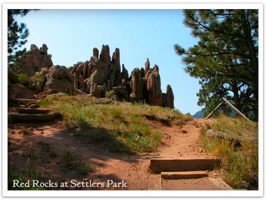
A giant underground sandstone formation runs from Ft. Collins all the way through Garden of the Gods in Colorado Springs. Here at Red Rocks Trail in Boulder, the rock juts out of the ground to transform the landscape. It makes for an inspiring short hike. Explore the hike snapshot and detailed trail profile below to get a feel for this great hike near Boulder.
Trail Snapshot: Red Rocks Trail at Settlers Park
| Hike Distance | 1 mile Loop + 0.4 mile spur |
|---|---|
| Difficulty | Easy |
| Duration | 45 min |
| Trail Type | Loop with Spur |
| Elevation Gain | +300′ |
| Seasons | All Year |
| Dogs | Allowed on Leash |
| Hike Trail Map | Click for a Map of Red Rocks & Anemone Trail |
| Denver Drive Time | 45 min |
| Directions | Click for Google Map |
| Town Nearest Hike | Boulder, Colorado |
| Beauty | Red Rock Formations |
| Activities | Picnic area, no bikes, hiking trails, rock climbing |
The trails of Red Rocks at Settlers Park in Boulder interconnect to form more of a labyrinth than a straightforward hike. But there is a way around all that—literally. Pull up the Boulder Open Space & Parks Map and follow the outer perimeter trail to form an approximately 1 mile loop around the sandstone red rock formations that jut out of the ground in the center of the park.
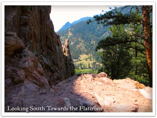
You can add an additional .8 mile to your hike by taking the Anemone trail to the west, rising another 400ft where it tops out on a hill to give you views of the City of Boulder, the Red Rocks Park, and the Colorado Front Range. Even with the Anemone trail spur, it’s a short hike, so you might want to add one of the Mt. Sanitas hiking trail options to your adventure. The Mt. Sanitas trail is just North of the Centennial Trailhead.
Tips & Resources for Hiking the Red Rocks Trail at Settlers Park :
- This trail is not to be confused with Red Rocks in Denver. If you are interested in hiking at Red Rocks in Denver, you can access a trail profile for the Trading Post Trail here.
- Getting There: You can access Boulder’s Red Rocks Trails from either the Centennial Trailhead or Settlers Park Trailhead parking areas.
- For information on rock climbing the rock formations in Settlers Park see the Mountain Project’s page.
- Trail Map for Settlers Park Boulder: Trail Map Link
- Colorado Road Conditions: Colorado Road Conditions
- After the Hike: Ozo Coffee

Weather
Map & Driving Directions
Click for Driving Directions


