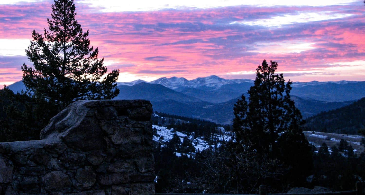
Mount Falcon - Castle & Tower Hike
A hike to castle ruins in Colorado? Yep. Throw in a lookout tower, a great view of Denver, of Red Rocks, and of the mountains, and you've got some of the highlights of the Mount Falcon Trail. The trailhead is nestled in a community in the foothills just about 40 minutes from Denver. Here we detail a 2.3-mile loop trail that hits all the destinations.
Trail Snapshot: Mount Falcon Castle & Tower Hike
| Hike Distance | Approx 2.3 miles |
|---|---|
| Difficulty | Easy |
| Duration | 1 hr 30 min+ |
| Trail Type | Loop |
| Seasons | All Year |
| Dogs | Allowed on Leash in Most Areas |
| Hike Trail Map | Click for a Trail Map |
| Denver Drive Time | 40 min |
| Directions | Click for Google Map |
| Town Nearest Hike | Morrison, Colorado |
| Beauty | Front Range views, Denver views, Fire Tower, ruins, & deer |
| Activities | Picnic area, horseback riding, mountain biking, hiking trails |
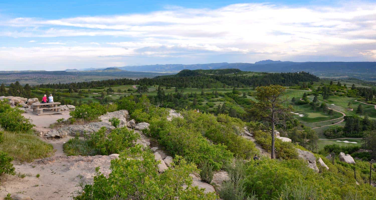
Mt. Falcon Loop Hike
Mount Falcon features several trails. By combining a few, you can create a 2.3-mile loop and take in several historic sites as well as breathtaking views of Denver, Red Rocks, and the Front Range. This makes it one of the best hikes close to Denver for visiting friends and family. Because it is an easy hike and has a relatively flat and wide trail, you can take the jogging stroller on this one, too. If you are looking for more great trails for your family, be sure to check out our Kid Friendly Trails Near Denver and our recommended Colorado Hikes for Visiting Friends and Family pages. If hiking with kids, be sure to access it via the West Trailhead as described in this post. Map apps and other sites may take you to the very demanding east trailhead, which is very exposed to the sun and has heavy mountain bike traffic.
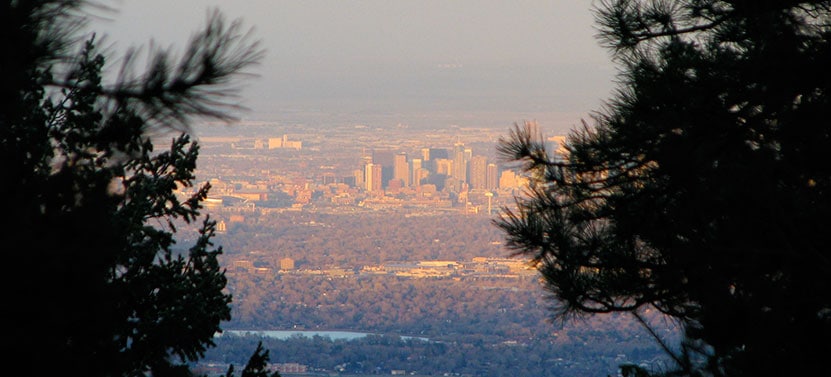
The Loop Trail Sequence:Start at the parking lot off of Mt. Falcon Road, and when you come to a fork in the trail, take the Tower Trail to your right. Soon you'll pass the Eagle Eye Shelter which offers great views towards Mount Evans and the surrounding foothills. Stay on the Tower Trail until you get to the Fire Tower which commands a panoramic view of Denver, Red Rocks, and more of the Front Range of Colorado.
Then continue on the Tower Trail until it intersects with the Meadow Trail. Take the Meadow Trail North/Left for about .3 miles. It will end at the Castle Trail - take a left. The Castle Trail will lead you back to the parking lot, but don't head back until you stop at the ruins of the old Walker Home. The views from here are beautiful as well.
Tips & Resources for Hiking Mt. Falcon:
- TIP: Bring a Lunch and stop at the Eagle Eye Shelter for a Picnic
- TIP: Go early or late to catch some of the best sunsets along the Colorado's Front Range
- Trail Map for Mount Falcon Park: Trail Map Link
- Colorado Road Conditions: Colorado Road Conditions
Weather
Map & Driving Directions

Rattlesnake Gulch Trail at Eldorado State Park
The Rattlesnake Gulch trail takes you up the sides of Eldorado Canyon, one of Colorado's historic State Parks. This lollipop trail takes you past the ruins of the Crags Hotel, then on to gain views of the Continental Divide. Scroll down to look over the trail snapshot, then explore the trail details and tips below for this rewarding hike in Eldorado Canyon State Park.
Trail Snapshot: Rattlesnake Gulch Trail at Eldorado Canyon
| Hike Distance | Approx 2.5 to 4 miles |
|---|---|
| Difficulty | Moderate |
| Duration | 1.5-2.5 hrs |
| Trail Type | Lollipop w/Spur Option |
| Seasons | Spring, Summer, Fall |
| Dogs | Allowed on Leash |
| Hike Trail Map | Click for a Trail Map |
| Denver Drive Time | 45 min |
| Directions | Click for Google Map |
| Town Nearest Hike | Boulder, Colorado |
| Beauty | Canyon, waterfalls and cascades, cliff swallows, cliff-top views, geologic features |
| Activities | Picnic areas, horseback riding, mountain biking, rock climbing |
| Fee | Link to Fees Page |
If your legs are ready to gain some quick elevation to some rewarding views, the Rattlesnake Gulch trail will give you just that. This trail starts at the west trailhead of the Fowler Trail about 1/2 a mile into Eldorado Canyon. The hike first takes you about 1.2 miles to the site of the Crags Hotel. The hotel was built in 1908 and visitors could reach it by taking an incline railroad and by an old wagon trail. In 1912, the hotel burnt to the ground, and just a few ruins remain. The parks department has put up interpretive signs to give you an idea of what the site was like in the early 1900's.
If you continue past the Crags Hotel site, you can add on an additional 1.4 miles by hiking the Rattlesnake Gulch Loop. A spur along the trail takes you to the Continental Divide overlook, where you can look out to the plains and towards a few peaks to the west. If you don't want to hike the entire loop, but you want to catch the view from the overlook, take the trail to the right after the hotel site and hike about 10 more minutes. See the map link above for the exact location of the spur that leads to the overlook.
The picture above is looking northeast towards the Cadillac Rock area. If you take a pair of binoculars, scan the formation for rock-climbers. Eldorado Canyon makes for some great Denver area hiking. It's one of those places with so many unique features, that you'll find yourself drawn back there time and time again.
Tips & Resources for Hiking the Rattlesnake Gulch Trail at Eldorado State Park:
- Exact Trail Length: Exact trail lengths are approximate until we can GPS this one. We've noticed discrepancies on maps and reports. So, be sure to add some buffer time on to this hike.
- Parking: Parking fills up fast at Eldorado Canyon. So, we suggest you go early in the day, or as the crowds are filtering out of the park in the late afternoon. As well, you'll find weekdays less crowed. Eldorado Canyon is open from sunrise to sunset year round.
- Directions: Use the driving directions on this page. They will lead you to the nearest parking area to the Rattlesnake Gulch Trailhead.
- Fee: There is an $8 parking fee per car or you can use your Colorado State Parks Annual Pass
- Trail Map for Eldorado Canyon State Park: Trail Map Link
- Colorado Road Conditions: Colorado Road Conditions
- After the Hike: Boxcar Coffee Roasters in Boulder
Weather
Map & Driving Directions
Click for Driving Directions

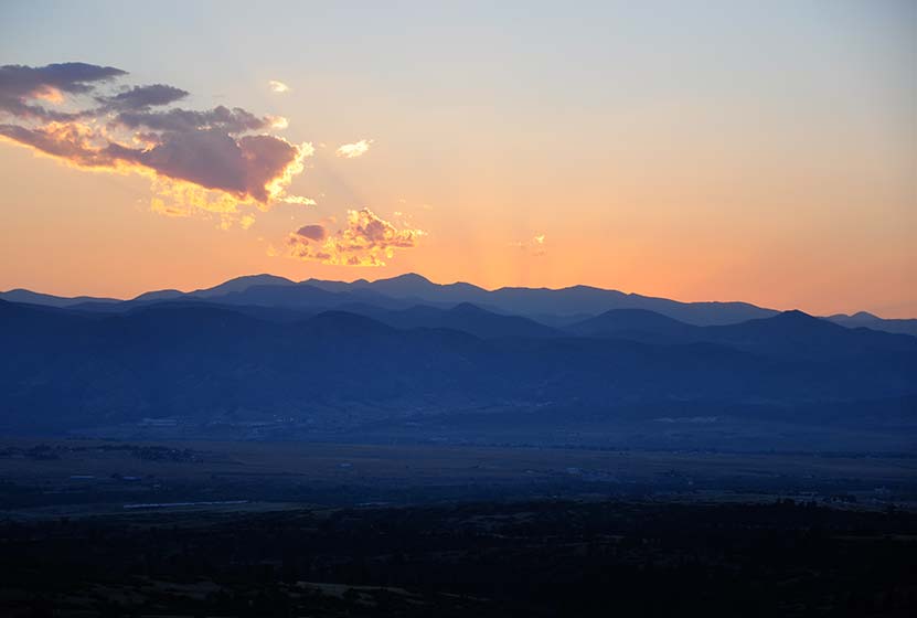
Daniel's Park Hikes
Best sunsets in Denver! You can see mountains upon mountains of Colorado's Front Range. Take a picnic dinner and pull off at one of the many picnic areas along Daniels Park Road. There are several hiking options detailed below for Daniel's park. To get all the details, scroll down and explore the trail snapshot, profile, and tips below.
Trail Snapshot: Daniel's Park Hike
| Hike Distance | 0.2, 3, or 5.4 Miles |
|---|---|
| Difficulty | Easy |
| Duration | 20 min to 2.5 hrs |
| Trail Type | Out and Back |
| Seasons | All Season |
| Dogs | Allowed on Leash |
| Hike Trail Map | Click for a Trail Map |
| Denver Drive Time | 35 min |
| Directions | Click for Google Map |
| Town Nearest Hike | Littleton, Colorado |
| Beauty | Front Range Views, Rock Formations, Bison |
| Activities | Picnic Areas, Shelter House with Fireplace, Bison viewing area, Hiking |
We are featuring Daniel's Park ,not for it's trails, but because it has one of the best views of the Front Range near Denver. From the park, you can see Pikes Peak in the South, Mt. Evans in the West, and Longs Peak in the North. The trails are not handicap accessible, but the shelter house is (after a bit of a bump trail), and is a perfect place to watch the sun set.
Here is the lowdown on the trails at Daniel's Park: They are undeveloped. The park has been around for nearly 100 years but has somehow escaped being developed. However, it's close to south Denver and has some great features, so we've come up with a few different hiking options below.
The Short Daniel's Park Hike - Park at the Shelter House and begin walking north through the undeveloped trails along the top of the bluff. We like to take a picnic dinner up here and a lot of folks bring firewood and enjoy the sunset by the fire. There are about a quarter mile of trails that weave through the rock and back out towards the road.
3 Mile Daniel's Park Hike - Again, start at the Shelter House and head North following the top of the bluff as it parallels the road. You can extend your hike by hiking North along the road until it intersects with Grigs Road - About 1.5 Miles. Hike back to Daniel's Park Shelter House for a 3 Mile round trip hike.
5.4 Mile Daniel's Park Hike - Continue the 1.5 mile hike by taking a left onto Grigs road. Cross to the Northeast side of the Grigs, then shortly after you cross, you'll come upon a green fence and the Douglas County East/West Trail. Your can take that trail West (left) to the Grigs Road Trailhead, adding an additional 1.2 miles to your hike (5.4 Miles Round Trip). Click Here for a Google Map that traces the route along Daniel's Park and Grigs Road.
Douglas County plans to build this East/West trail into a 26 mile system linking Chatfield Reservoir to the town of Parker, Colorado. Click here for the map of the East/West Trail and proposed trails in Douglas County. Denver Mountain Parks and Douglas County have developed a master plan to improve both the park and the roads in the area. You can find an overview at the Douglas County Park site.
Tips & Resources for Visiting Daniel's Park:
- TIP: Keep an eye on the skies - Douglas County has one of the highest lightning strike rates in the country and Daniel's Park is one of the higher points.
- TIP: Bison Viewing - The Bison can be found in an enclosed pasture on both sides of the road.However, the Bison are usually found grazing in the section of the park that is directly across the street from the shelter house.
- Trail Map for Daniel's Park: Trail Map Link
- Colorado Road Conditions: Colorado Road Conditions
Weather
Map & Driving Directions
Click for Driving Directions
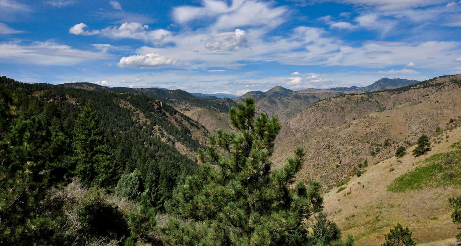
Chimney Gulch Trail at Windy Saddle Park
It's a demanding hike up Chimney Gulch near Golden, Colorado, but the views at the top are worth the workout. This hiking trail crosses streams as it zigzags up the side of local landmark, Lookout mountain. Explore the full Chimney Gulch hike profile below for trail map, driving directions, and more tips and details to help you enjoy this adventure in Windy Saddle Park.
Trail Snapshot: Chimney Gulch Trail at Windy Saddle Park
| Hike Distance | 5 miles Round Trip |
|---|---|
| Difficulty | Moderate to Difficult |
| Duration | Approx 2.5+ hrs |
| Trail Type | Out and Back |
| Seasons | All Season |
| Dogs | Allowed On Leash |
| Hike Trail Map | Click for a Map of Chimney Gulch Trail Map |
| Denver Drive Time | 25 min |
| Driving Directions to Chimney Gulch Trailhead | Click for Google Map |
| Town Nearest Hike | Golden, Colorado |
| Beauty | Rocky Mountain vista at top, views of Golden & Denver |
| Activities | Hiking, mountain biking, trail running |
The Hike: Chimney Gulch Trail
Steep - that's probably the best adjective for this hike. The trail is very accessible from Denver - on average, just a 25 minute drive. The trail begins at the base of Lookout Mountain in Golden and weaves it's way to the top, crossing the road twice, to a wonderful mountain vista. It's a perfect place, complete with benches, for viewing sunsets. However, a hike down in the twilight may be pretty difficult to negotiate. The Chimney Gulch Trail joins up with both the Beaver Brook Trail, and Lookout Mountain Trail. See the link to the trail map above for details.
Tips & Resources for Hiking the Chimney Gulch Trail
- TIP: Because the trail can be narrow and has a lot of mountain bike traffic, we suggest leaving the dog at home.
- TIP: If you want to start at the top, you can park at the Windy Saddle Trailhead along Lookout Mountain Road. Click for Google map and driving directions.
- Adjust Expectations: If you are hoping for a quiet, solitary hike, this is probably not the best choice. Because this trail is very accessible and challenging, there is a lot of hiking, running, and biking traffic.
- For a great detailed trail description: , check out Deb Stanley's Chimney Gulch Trail profile.
- Trail Map for Chimney Gulch Trail: Trail Map Link
- Packing List: Always pack the 10 Essentials. Download our Hiking Guide to get the list and dayhiking packing checklist.
- Colorado Road Conditions: Colorado Road Conditions
- After the Hike: Cafe 13
Weather
Map & Driving Directions for Chimney Gulch Trailhead
Click for Driving Directions
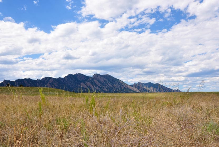
Flatirons Vista Loop Trail
If you are yearning for wide open spaces, the Flatirons Vista trail near Boulder, Colorado makes for a perfect hike. The trail has two loop options and links up to other hiking trails along the Flatirons. Explore the trail profile of this classic Colorado hike for a trail map and all the details like driving directions, trail difficulty rating, and distances.
Trail Snapshot: Flatirons Vista Loop Trail
| Hike Distance | 1.9 or 3.3 Miles |
|---|---|
| Difficulty | Easy to Moderate |
| Duration | 1 to 2.5 hrs |
| Trail Type | Loop |
| Seasons | All Season |
| Dogs | Allowed on Leash |
| Hike Trail Map | Click for a Trail Map |
| Denver Drive Time | 40 min |
| Directions | Click for Google Map |
| Town Nearest Hike | Boulder, Colorado |
| Beauty | Views of the Flatirons, Meadows, Ponderosa Pines, Wildlife: Bobcat, Bear, Mule Deer, Eagles (in winter), & coyote |
| Activities | Hiking Trails, Horseback Riding, Mountain Biking, Birdwatching, & Trail Running |
| Fee | $5 Parking fee or $25 Annual Pass |
You've got options. The Flatiron Vista Loop trail offers 2 loops. One is 3.3 miles and the other is just 1.9 miles. They will wind you through the ponderosa pines and meadows that skirt of the famous Flatirons just south of Boulder. It's an easy hike and a trail runner's dream. The Flatiron Vista Loops are a great destination for winter hikes as well. That's the time of year that you are likely to spot both Golden and Bald Eagles.
The Loops:
-
Longer Flatiron Vista Loop -3.3 miles:
Take the South Flatiron Vista trail (about .2 miles down the trailhead connector trail). After 2.4 miles, bear right onto the North Flatiron Vista Trail. Then, after 1 mile, take the connector trail you came in on back to the trailhead. (reverse this if you like).
-
Shorter Flatiron Vista Loop -1.9 miles:
Take the South Flatiron Vista trail (about .2 miles down the trailhead connector trail). After approx. 1 miles bear right onto Prairie Vista Trail. Continue about 1 mile, then take the connector trail you came in on back to the trailhead

Tips & Resources for Hiking at Flatirons Vista:
- No Shade: The trails at Flatirons Vista are very exposed. Bring a hat and use the sunscreen.
- Trail Map for Flatirons Vista Trail: Trail Map Link
- Colorado Road Conditions: Colorado Road Conditions
- After the Hike: Windy Saddle Cafe
Weather
Map & Driving Directions
Click for Driving Directions
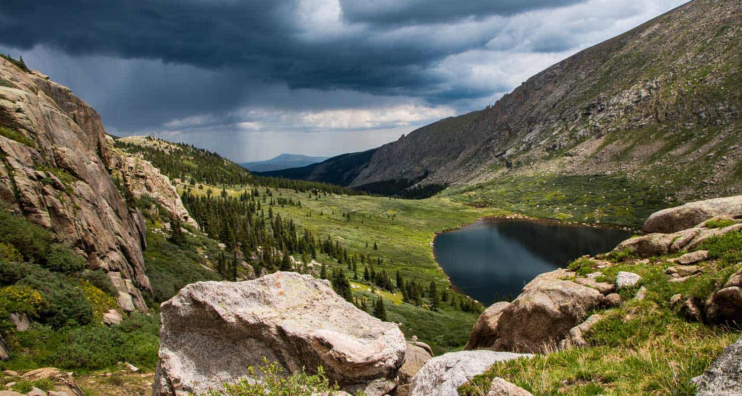
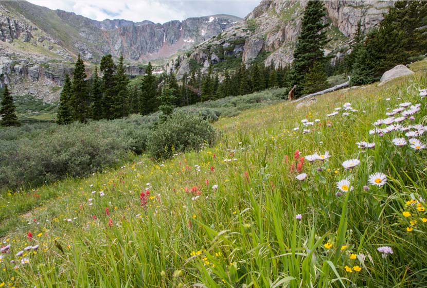
Chicago Lakes Hike Near Mt. Evans
Want to take in some of Colorado's breathtaking scenery and put some miles under your hiking boots? The Chicago Lakes hike begins at Echo Lake. You'll pass three more mountain lakes as you punch up into the high country of Colorado's Mt. Evan's Wilderness. Explore the full trail profile below for the Chicago Lakes which includes driving directions, map, and tips.
Trail Snapshot: Chicago Lakes Hike Near Idaho Springs, Colorado
| Hike Distance | 8.4 to approx 10 miles RT |
|---|---|
| Difficulty | Difficult |
| Duration | Approx 5-7hrs |
| Trail Type | Out and Back |
| Elevation Gain | Approx +1200′ |
| Seasons | Summer to Fall |
| Dogs | Allowed On Leash |
| Hike Trail Map | Click for a Map of Chicago Lakes |
| Denver Drive Time | 1 hr |
| Driving Directions to Chicago Lakes Trail | Click for Google Map |
| Town Nearest Hike | Idaho Springs, Colorado |
| Beauty | Lakes, Mountain Peak Views, Creek, High Country, Cliffs, Wildflowers, & Wildlife: Mountain Goats, Bighorn Sheep, Elk |
| Activities | Hiking, wildlife viewing |
| Weather for Mt. Evans | Click Here |
Looking for amazing views and some high mountain lakes near Denver? This challenging hike takes you to two high mountain lakes with amazing views of the Mt. Evans Wilderness area. Both lakes can be fished, as well as the lower Idaho Springs Reservoir that you pass on your way. We are not into giving long trail descriptions on Dayhikes Near Denver, but we'd suggest you read the basic one below and check out the trail description and pdf Chicago Lakes map link in the trail profile below.
The Chicago Lakes Trailhead and Trail: Park at the Echo Lake lot, where you'll find the sign for Chicago Lakes Trail 52 on the west side of the lake. That will lead you to another sign about .5 mile later directing you to the trail. The trail will turn into Idaho Springs Reservoir Road, then will return to a normal trail. It climbs through a burn area, the result of a fire in the 1970s, then continues to climb to Lower Chicago lake. The trail has a lot of character: steep areas, massive cliff walls, and expansive meadows. The trail continues, faint at times, up a steeper section to Upper Chicago Lake.
As you'll see in the comments on this hike, people come back with different trail lengths. So, to clear this up: Beginning at Echo Lake, the trail is 4.24 miles one-way to the lake. However, most people don't want to stop there, many continue on to the upper lake, which adds and additional .6 mile to the trail. Then, some people opt to hike around the lake, which adds to the hike as well. You may want to start early, especially in the Summer months so that you have the time to explore and to avoid our famous, afternoon Colorado thunderstorms.
Tips & Resources for Hiking Chicago Lakes Near Mt. Evans, Colorado :
- TIP: Don't Miss: 1 - The Upper Lake & 2 - The Cascade between the two lakes
- TIP: Check the Weather before heading up. Use the following link to National Weather Service page for Mt. Evans
- TIP: Look Over trail descriptions from Deb Stanley & David Day before heading out.
- Trail Map for Chicago Lakes Near Mt. Evans: Trail Map Link
- Colorado Road Conditions: Colorado Road Conditions
- After the Hike: Finish your hike by enjoying a slice of Barbara Day's famous pie at Echo Lake Lodge
- Photo: We would like to express our gratitude to Shea Oliver for sharing such an amazing photograph of this hike.
Weather
Map & Driving Directions
Click for Driving Directions
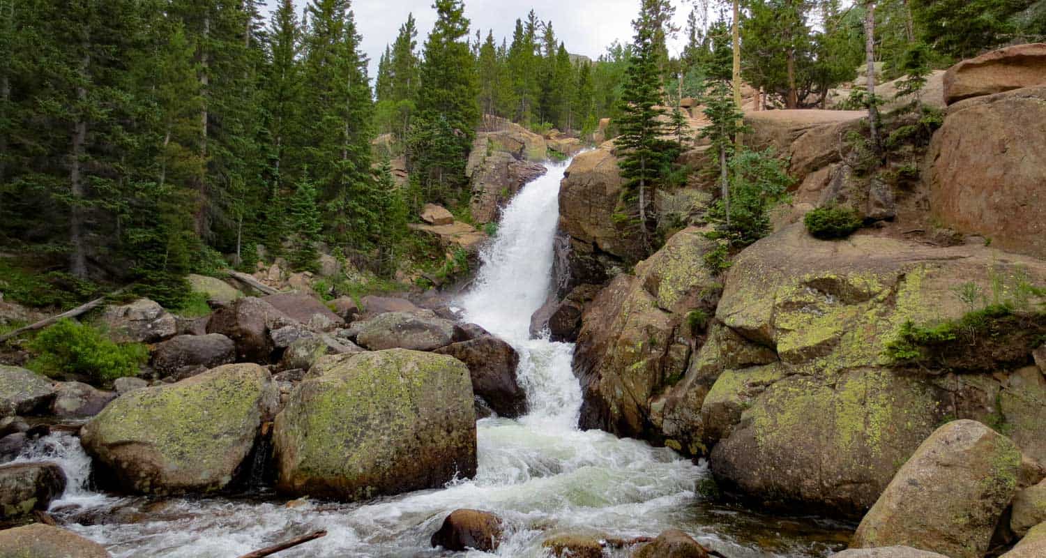
Alberta Falls Hike at Rocky Mountain National Park
Colorado's Rocky Mountain National Park is full of waterfalls and this hike takes you to one of the most accessible waterfalls in the park. Alberta Falls is one of the most popular, short destination hikes in the park, and for good reason. If you only have time for one short hike on the East Side of RMNP, this is a great choice. To get to Alberta Falls, park at the Bear Lake Trailhead (see google directions below), then follow the signs south for Glacier Gorge and Alberta Falls. The waterfall is .8 miles down the trail from the parking area, make this a 1.6 mile out-and-back hike. Start early and hike the full 2.8 miles of trail in to stunning Mills lake inside Glacier Gorge.
Note: Rocky Mountain National Park now requires timed entry permits from May 27th through October 10th. See the RMNP permits page for more information.
| Hike Distance | 1.6 miles Round Trip |
|---|---|
| Difficulty | Medium |
| Duration | Approx 1 hr |
| Trail Type | Out and Back |
| Seasons | Spring thru Fall |
| Dogs | Prohibited in the Park |
| Hike Trail Map | Click Here for a Trail Map |
| Denver Drive Time | 2 hrs |
| Driving Directions to Alberta Falls, Colorado | Click for Google Map |
| Town Nearest Hike | Estes Park, Colorado |
| Beauty | Sub-Alpine Lake, Mountain Views, Wildlife: Abert's Squirrel, Elk, Bear |
| Activities | Picnicking, Hiking Trails, Snowshoeing |
| Fee | Park Pass Required |
Tips & Resources for Hiking to Alberta Falls
- Visitors and Vacationers: Alberta Falls is a great place to take visiting family and friends because it's not too difficult, and you have a lot of options if you want to explore the park
- Bring a Lunch: Getting this far into the park, even just driving, is quite a trip from the outside world. We suggest packing a lunch so that you can stay longer. And food just tastes better outside anyway.
- Trail Map for Bear Lake Corridor: Trail Map
- Rocky Mountain National Park Maps: Maps Link
- Colorado Road Conditions: Colorado Road Conditions
- After the Hike: Poppy's Pizza
 Looking for more waterfalls near Denver? Explore our more than 50 Colorado Waterfall Hikes, our favorite Waterfall Hikes in Rocky Mountain National Park, or 7 Waterfalls within One Hour of Denver.
Weather
Map & Driving Directions
Click for Driving Directions
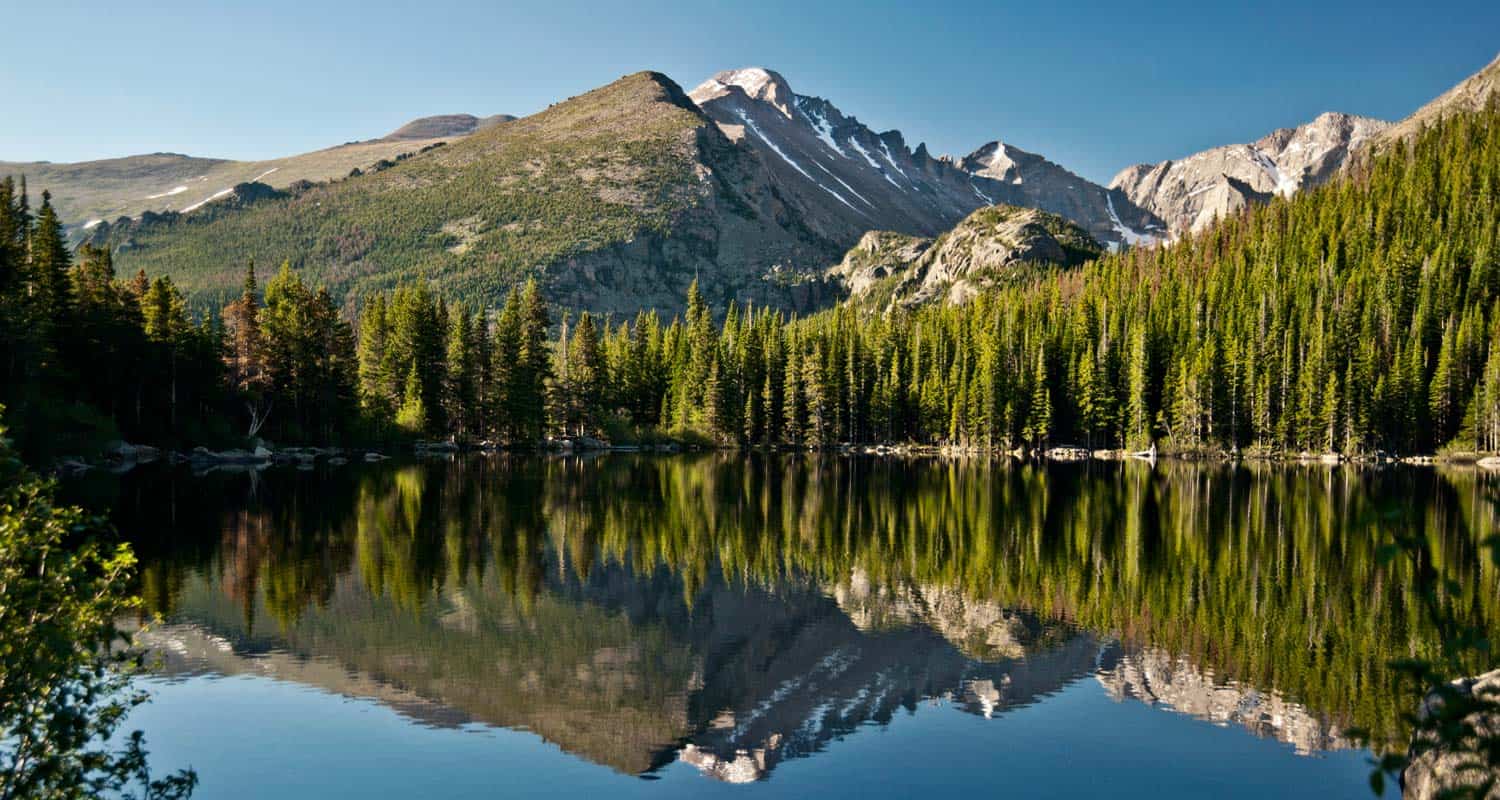
Bear Lake Hike at Rocky Mountain National Park
From Bear Lake in Rocky Mountain National Park (just 2 hours from Denver), you can launch out on dozens of hiking adventures, trails that range from less than a mile to full day treks back into Glacier Gorge or Andrews Creek. If you are visiting Colorado and looking for a high variety of trails or just a good place to start your vacation, this is one of the best places in the state. For details on the trail, see the hiking trail profile below, and download the trail map to get an idea of the different hikes that begin at Bear Lake.
Note: Rocky Mountain National Park now requires timed entry permits from May 27th through October 10th. See the RMNP permits page for more information.
Trail Snapshot: Bear Lake in Rocky Mountain National Park
| Hike Distance | 0.6 mile loop |
|---|---|
| Difficulty | Easy |
| Duration | Approx 30 min |
| Trail Type | Loop |
| Starting Elevation | 9475′ |
| Elevation Gain | +20′ |
| Seasons | Year Round |
| Dogs | Dogs Prohibited in RMNP |
| Hike Trail Map | Click for a Trail Map |
| Denver Drive Time | 2 hours |
| Driving Directions to Bear Lake Trailhead | Click for Google Map |
| Town Nearest Hike | Estes Park, Colorado |
| Beauty | Sub-Alpine Lake, Mountain Views, Wildlife: Abert's Squirrel, Elk, Bear |
| Activities | Picnicking, Snowshoeing, Hiking Trails |
| Conditions at Bear Lake Trailhead | Click Here |
| Fee | Park Pass Required |
Bear lake is the epicenter of Rocky Mountain National Park. This means that you can access a ton of trails from here, but it also means a lot of traffic. So, we always recommend getting there early, on weekdays, and to go during the off-season - if you can. The Bear Lake Trail is a short 0.6 mile loop around a beautiful lake with views of the Rocky Mountains. The hike is considered handicap accessible; however, the trail is not paved.
Tips & Resources for Hiking Bear Lake In Rocky Mountain National Park :
- For Disabled Visitors: Check out the Disabled Travelers' Companion Website for great info and pictures on more accessible trails in RMNP
- Check out: See our Handicap Accessible Hikes Page for more hikes as well
- Visiting Family & Friends: This is a great place to take visiting family and friends because it's not too difficult, and you have a lot of options if you want to explore the park
- Bring a Lunch: Getting this far into the park, even just driving, is quite a trip from the outside world. We suggest packing a lunch so that you can stay longer. And food just tastes better outside anyway.
- Trail Map for Rocky Mountain National Park: Trail Map Link
- Colorado Road Conditions: Colorado Road Conditions
- Photo Courtesy of Ben Grey.
- After the Hike: Poppy's Pizza
Weather
Map & Driving Directions
Click for Driving Directions

Bluffs Loop Trail at Bluffs Regional Park
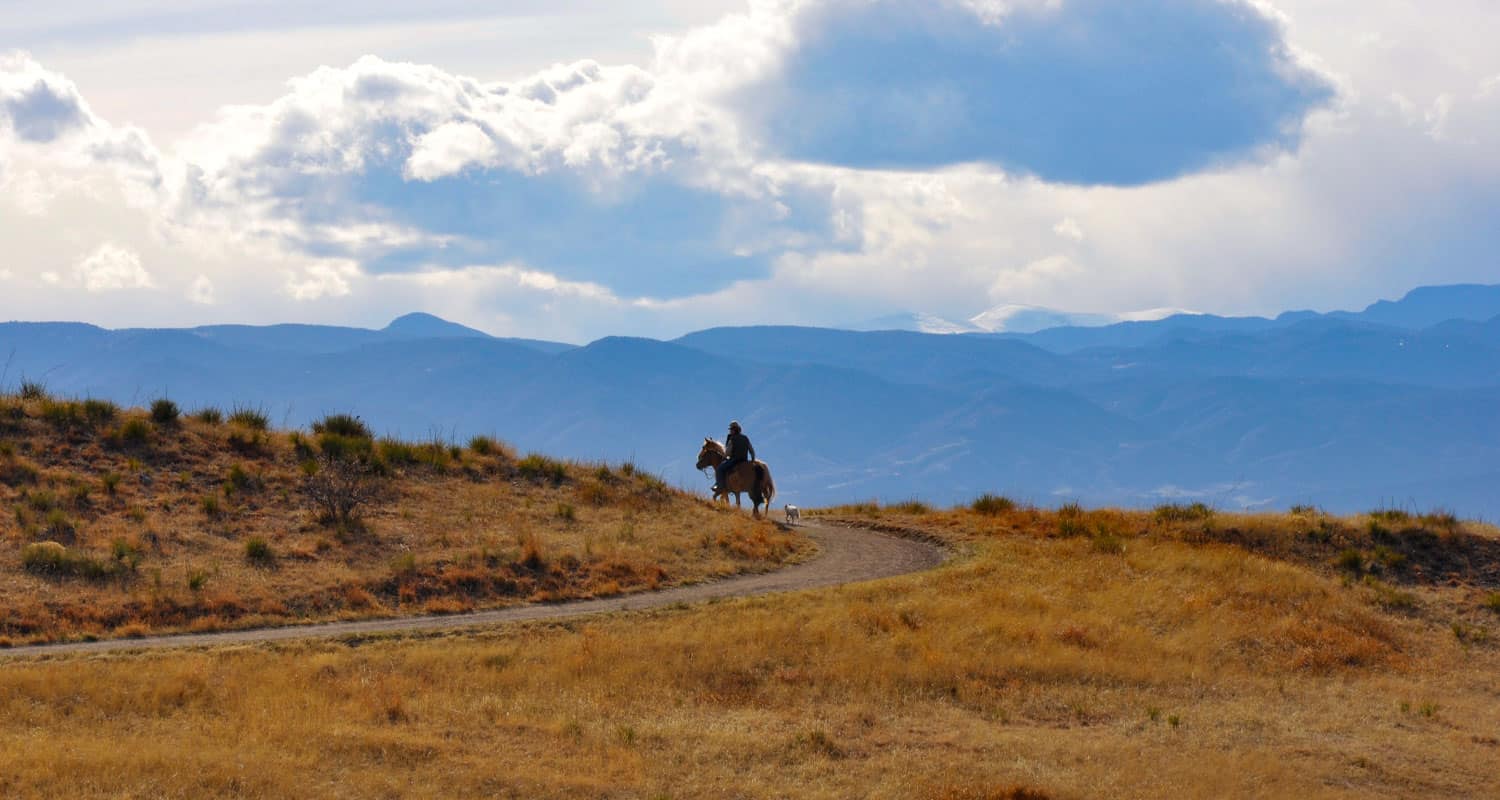
The Bluffs Regional Park features a 2.7 mile loop hike and 2 spurs that lead to panoramic overlooks. The Bluffs loop offers fantastic views of Denver and of the front range. We prefer hitting the trail as the sun is setting. As it gets dark, and the city lights begin to appear, warm winds sometimes will kick up along the Bluffs. Because it's so close to home, we have hiked the Bluffs more than any other trail near Denver. It's the best hike in Lone Tree, it's near Highlands Ranch, and can be made into either a great hike or trail run. We have often taken our jogging stroller, put the kids in, and hiked the loop. This makes for a great after-work workout.
Trail Snapshot: Bluffs Loop Trail at Bluffs Regional Park
| Hike Distance | 2.7 Miles+Spurs |
|---|---|
| Difficulty | Easy |
| Duration | Approx. 1 hr 45 min+ |
| Trail Type | Loop |
| Elevation Gain | Approx. +200' |
| Seasons | Summer & Fall |
| Dogs | Allowed On Leash |
| Hike Trail Map | Click for a Map of Bluffs Loop Trail at Bluffs Regional Park |
| Denver Drive Time | 30 min |
| Driving Directions to Bluffs Loop Trail at Bluffs Regional Park | Click for Google Map |
| Town Nearest Hike | Littleton, Colorado |
| Beauty | Grassland, Front Range views, bluff overlooks, wildlife: prairie dogs, rabbits, red fox |
| Activities | Picnic area, horseback riding, mountain biking, hiking trails |
Because the Bluffs Regional Park is just a few minutes off of Interstate 25, it's a great place to meet friends who may be driving up from Castle Rock or Monument.
Be aware of horses on the trail and give them the right of way. There is a gentleman who likes to ride his horse in the late afternoon/early evening who can be quite reckless. We've seen him nearly collide with parties of hikers on two occasions. Just be aware of him.
2 Hike Options at the Bluffs Regional Park :
1. The Loop Hike: We prefer to hike the loop counter-clockwise (going right onto the trail from the trailhead) because the steepest part of the trail is downhill at the end. The trail does have a steady incline on the back side that can be challenge if you are pushing a stroller. This loop hike is 2.7 miles + spurs out to two overlooks.
2. Hike Directly to the Overlook: The most direct route to the Tepe Overlook at the Bluffs is by following the trail clockwise (to the left) from the trailhead for half a mile, then to follow the spur trail for .2 mile to the overlook. This makes for a 1.4 mile, out-and-back hike.
Tips & Resources for Hiking Bluffs Loop Trail at Bluffs Regional Park :
- TIP: The parking lot usually fills up on weekend mornings before 9-9:30AM.
- TIP: As there is no water available at the trailhead, you would want to bring some with you.
- Trail Map for Bluffs Loop Trail: Trail Map Link
- Colorado Road Conditions: Colorado Road Conditions
- After the Hike: DazBog Coffee
Weather
Map & Driving Directions
Click for Driving Directions
Crown Hill Lake Trails
Jefferson County seems to turn to gold about every park they touch here in Colorado. Crown Hill Lake Park is a prime example. It's an oasis in the midst of the busy city of Denver. The park has beautiful views of the Front Range mountains, including the Flatirons down in Boulder.
Crown Hill Lake Park has three miles of paved trails and .7 of them are considered ADA accessible, all in the heart of Denver. On the northwest side of the park, you'll find a wildlife sanctuary for migratory birds. Explore the full trail profile below for all the details: hiking trails, trail map, and detailed directions to the trailhead.
Trail Snapshot: Crown Hill Lake Trails
| Hike Distance | 1.2 miles+ |
|---|---|
| Difficulty | Easy |
| Duration | Approx 45mins+ |
| Trail Type | Loop |
| Seasons | All |
| Dogs | Allowed on Leash in Most Areas |
| Hike Trail Map | Click for a Map of Crown Hill Lake Trails |
| Denver Drive Time | 17 min |
| Driving Directions to Crown Hill Lake Trails | Click for Google Map |
| Town Nearest Hike | Lakewood, Colorado |
| Beauty | Lake, wildlife sanctuary, Front Range views, wildlife: ducks, geese |
| Activities | Horseback riding, cycling, fishing, hiking, picnic areas |
Hikes at Crown Hill Park:
- Loop Trail - 1.2miles - goes around the lakeside
- Perimeter Trail - 2 miles - goes around the edge of the park
- Nature Preserve Trail / Wildlife Sanctuary Trail - .7 mile - Hiker Only and ADA accessible trail
- Link to the Park's Map
Tips & Resources for Hiking Crown Hill Lake Trails :
- TIP: It's a busy park, so try earlier and later in the day.
- TIP: The wildlife preserve is hiker only. No dogs in this area.
- TIP: There is a lot of multi-use traffic on the trails, so be alert and yield when appropriate.
- Trail Map for Crown Hill Park: Trail Map Link
- Colorado Road Conditions: Colorado Road Conditions
- After the Hike: Danny's Carnation Restaurant
- Photo: We would like to express our gratitude to Kasey Cline for sharing such an amazing photograph of this hike.
Weather
Map & Driving Directions
Click for Driving Directions