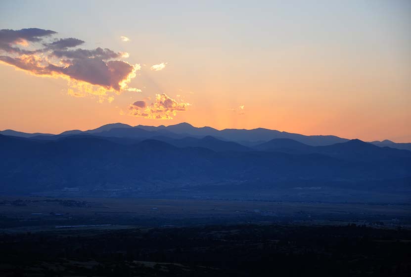
Best sunsets in Denver! You can see mountains upon mountains of Colorado’s Front Range. Take a picnic dinner and pull off at one of the many picnic areas along Daniels Park Road. There are several hiking options detailed below for Daniel’s park. To get all the details, scroll down and explore the trail snapshot, profile, and tips below.
Trail Snapshot: Daniel’s Park Hike
| Hike Distance | 0.2, 3, or 5.4 Miles |
|---|---|
| Difficulty | Easy |
| Duration | 20 min to 2.5 hrs |
| Trail Type | Out and Back |
| Seasons | All Season |
| Dogs | Allowed on Leash |
| Hike Trail Map | Click for a Trail Map |
| Denver Drive Time | 35 min |
| Directions | Click for Google Map |
| Town Nearest Hike | Littleton, Colorado |
| Beauty | Front Range Views, Rock Formations, Bison |
| Activities | Picnic Areas, Shelter House with Fireplace, Bison viewing area, Hiking |
We are featuring Daniel’s Park ,not for it’s trails, but because it has one of the best views of the Front Range near Denver. From the park, you can see Pikes Peak in the South, Mt. Evans in the West, and Longs Peak in the North. The trails are not handicap accessible, but the shelter house is (after a bit of a bump trail), and is a perfect place to watch the sun set.
Here is the lowdown on the trails at Daniel’s Park: They are undeveloped. The park has been around for nearly 100 years but has somehow escaped being developed. However, it’s close to south Denver and has some great features, so we’ve come up with a few different hiking options below.
The Short Daniel’s Park Hike – Park at the Shelter House and begin walking north through the undeveloped trails along the top of the bluff. We like to take a picnic dinner up here and a lot of folks bring firewood and enjoy the sunset by the fire. There are about a quarter mile of trails that weave through the rock and back out towards the road.
3 Mile Daniel’s Park Hike – Again, start at the Shelter House and head North following the top of the bluff as it parallels the road. You can extend your hike by hiking North along the road until it intersects with Grigs Road – About 1.5 Miles. Hike back to Daniel’s Park Shelter House for a 3 Mile round trip hike.
5.4 Mile Daniel’s Park Hike – Continue the 1.5 mile hike by taking a left onto Grigs road. Cross to the Northeast side of the Grigs, then shortly after you cross, you’ll come upon a green fence and the Douglas County East/West Trail. Your can take that trail West (left) to the Grigs Road Trailhead, adding an additional 1.2 miles to your hike (5.4 Miles Round Trip). Click Here for a Google Map that traces the route along Daniel’s Park and Grigs Road.
Douglas County plans to build this East/West trail into a 26 mile system linking Chatfield Reservoir to the town of Parker, Colorado. Click here for the map of the East/West Trail and proposed trails in Douglas County. Denver Mountain Parks and Douglas County have developed a master plan to improve both the park and the roads in the area. You can find an overview at the Douglas County Park site.
Tips & Resources for Visiting Daniel’s Park:
- TIP: Keep an eye on the skies – Douglas County has one of the highest lightning strike rates in the country and Daniel’s Park is one of the higher points.
- TIP: Bison Viewing – The Bison can be found in an enclosed pasture on both sides of the road.However, the Bison are usually found grazing in the section of the park that is directly across the street from the shelter house.
- Trail Map for Daniel’s Park: Trail Map Link
- Colorado Road Conditions: Colorado Road Conditions
Weather
Map & Driving Directions
Click for Driving Directions


6/2/13 Update – The Bison are out with their calves in the bison pasture.
11/25/14- Just to clarify, there is no trail beyond the picnic area. You are literally walking on a busy road or next to it until Grigs road. Even then the trail is right next to the road. The view from the shelter house/picnic area is gorgeous, but save yourself the time and drive the road to see the rest of the ridge. Would be a nice addition to a long run or bike ride.
Nice views from here, and definitely a nice picnic area. Popular with the local teens.
All the ‘hiking’ being talked about here in regard to the 3 and 5.4 mile options is literally nothing more than walking on or next to the road as cars drive by… There is an actual biking/walking path near the shelter house parking lot, but it is across the street (opposite side from the views) and heads back down towards the residential areas. Your view along this path is the bison pen/chain link fence for most of the way.
There are any number of open spaces in douglas and jefferson county that are better options for hiking with equal/better views. This is a nice spot to eat lunch if you’re nearby though.
Daniels Park is not worth the drive from Denver. Your better off heading up into the foot hills, you’ll get a better bang for your buck. The teenagers have ransacked this place and pretty much taken over. Not worth fighting traffic to come here.