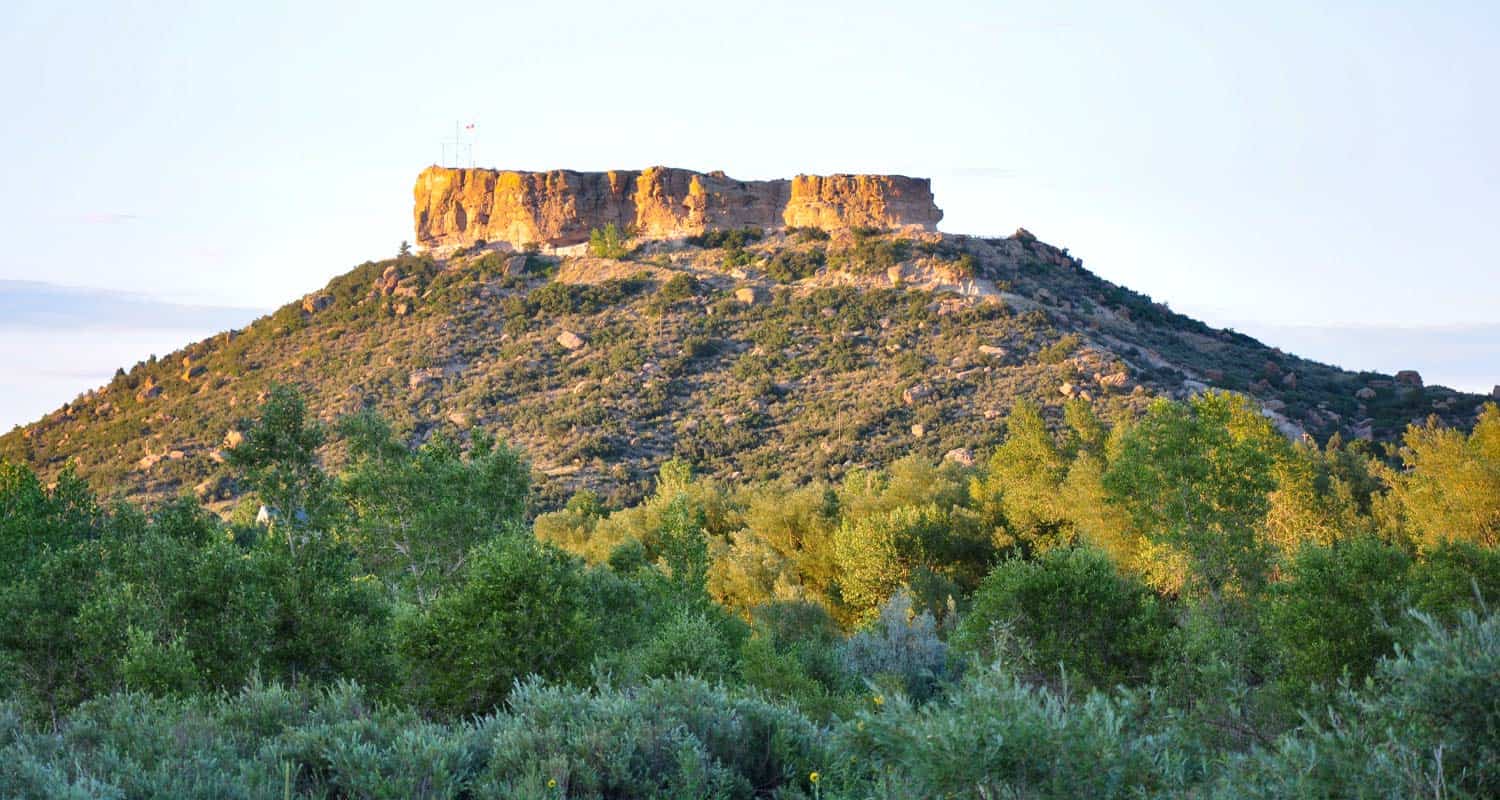
Castle Rock Trail
Rock Park in Castle Rock, Colorado is the trailhead for a 1.4 mile loop within a loop hike that climbs to the base of the town's famous Castle Rock. Click here for the Castle Rock trail map. Explore Dayhikes Near Denver for more hikes in Colorado with impressive rock formations.
Trail Snapshot: Castle Rock Trail
| Hike Distance | 1.4 Miles+Spurs |
|---|---|
| Difficulty | Moderate (can be difficult over rocks) |
| Duration | Approx. 1 hr+ |
| Trail Type | Loop |
| Starting Elevation | 6220' |
| Elevation Gain | Approx. +370' |
| Seasons | All |
| Dogs | Allowed On Leash |
| Hike Trail Map | Click for a Map of Castle Rock Trail |
| Denver Drive Time | 35 min |
| Driving Directions to Castle Rock Trail | Click for Google Map |
| Town Nearest Hike | Castle Rock, Colorado |
| Beauty | Historical monument, rock formations, Front Range views, wildlife: rock squirrels and cliff swallows |
| Activities | Hiking trails, picnic areas, no bikes or horses are allowed |
Tips & Resources for Hiking Castle Rock Trail :
- TIP: There is a panoramic view of Castle Rock at the top. Pike's Peak can be seen to the southwest, and Long's Peak to the northwest.
- TIP: A wide, flat path encircles the rock with a picnic area. Tables are available.
- Trail Map for Castle Rock Trail: Trail Map Link
- Colorado Road Conditions: Colorado Road Conditions
- After the Hike: Crowfoot Valley Coffee
Weather
Map & Driving Directions
Click for Driving Directions

Glendale Farm Trail - Douglas County Open Space
Glendale Farm is a short hiking trail near Littleton, Colorado, that offers a seventeen-acre off-leash dog park. This makes for a great after-work trail run or a leisurely hike when the sun is setting over the mountains and the day is cooling down. Glendale Farm Open space is situated on a prairie plateau between Lone Tree and Castle Pines, Colorado. From the high point on the trail you'll gain views of Pikes Peak in the south, Devil's head in the west, and Rocky Mountain's Longs Peak in the North. It's just a 1.6 mile loop trail, so it makes for a great run or hike. There's not much shade on this trail, so bring sunscreen--or better yet, hit the trail as the sunsets.
Trail Snapshot: Glendale Farm Trail - Douglas County Open Space
| Hike Distance | 1.6 mile |
|---|---|
| Difficulty | Easy |
| Duration | Approx 45 min |
| Trail Type | Loop |
| Seasons | All Year |
| Dogs | Allowed On Leash |
| Hike Trail Map | Click for a Map of Glendale Farm Trail - Douglas County Open Space |
| Denver Drive Time | 35 min |
| Driving Directions to Glendale Farm Trail - Douglas County Open Space | Click for Google Map |
| Town Nearest Hike | Littleton, Colorado |
| Beauty | Grassland, Front Range views, Cherry Creek, wildlife: pronghorn antelope, rattlesnakes, prairie dogs, deer, rabbits, scrub jays, & spotted towhees |
| Activities | Picnic areas, horseback riding, mountain biking, adjacent dog park |
This is another one of those great hikes with your Dog near Denver. Leashes are required on the trail, but after doing the loop, you can let your dog loose in the adjacent 17 acre off-leash dog park. Greenland Open Space Trail has a similar off-leash dog park of 17 acres.
Tips & Resources for Hiking Glendale Farm Trail - Douglas County Open Space :
- An off-leash dog area: Located southwest of the main trailhead is a 17-acre parcel designated park that is fenced-in, and the only area where dogs are allowed off-leash.
- Watch your step: Prickly pear cacti grow along the trail and there are rattlesnakes present in the area.
- Trail Map for Glendale Farm Open Space: Trail Map Link
- Colorado Road Conditions: Colorado Road Conditions
- After the Hike: Crowfoot Valley Coffee
- Rules: For the most up-to-date rules and info in Douglas County dog parks, see this brochure.

Weather
Map & Driving Directions
Click for Driving Directions


Arthur's Rock Trail in Lory State Park
The Arthurs Rock trail in Lory State Park near Fort Collins, Colorado ends with a beautiful panoramic views. You'll pass through meadows, forest, then end your hike with a scramble to the top of Arthur's Rock. Dogs are allowed on a leash, just be sure to bring plenty of water as there are not many places to access drinking water.
| Hike Distance | 3.4 miles RT |
|---|---|
| Difficulty | Moderate |
| Duration | Approx 1 hr 15 min Round Trip |
| Trail Type | Out and Back |
| Starting Elevation | 5600′ |
| Elevation Gain | +1180′ |
| Seasons | Spring to Fall |
| Dogs | Allowed On Leash |
| Hike Trail Map | Click for a Map of Arthur’s Rock Trail in Lory State Park |
| Denver Drive Time | 1 hr 25 min |
| Driving Directions to Arthur’s Rock Trail in Lory State Park | Click for Google Map |
| Town Nearest Hike | Fort Collins, Colorado |
| Beauty | Views of Horsetooth Lake, views of the Front Range, forests, and meadows, wildlife: elk, bobcat, and many bird species |
| Activities | Hiker only trail, but park offers picnic areas, horseback riding, mountain biking, canoeing, & kayaking |
Arthur's Rock History
The place got its name from Arthur Howard who was the one who, along with his brother, Charlie, sold this piece of land. For more information on the history of Arthur's Rock and Lory State Park, visit this page.
Tips & Resources for Hiking Arthur’s Rock Trail in Lory State Park :
- TIP: There is a visitor's center near the Lory State Park entrance.
- TIP: At the summit of Arthur's Rock, there is a beautiful view of Horsetooth Reservoir and the Front Range available.
- Trail Map for Lory State Park: Trail Map Link
- Colorado Road Conditions: Colorado Road Conditions
- After the Hike: The Colorado Room
- Photo: We would like to express our gratitude to Luci Westphal for sharing a great photo of her hike to Arthur's Rock at Lory State Park. Check out her video from this hike.
Weather
Map & Driving Directions
Click for Driving Directions to Lory State Park