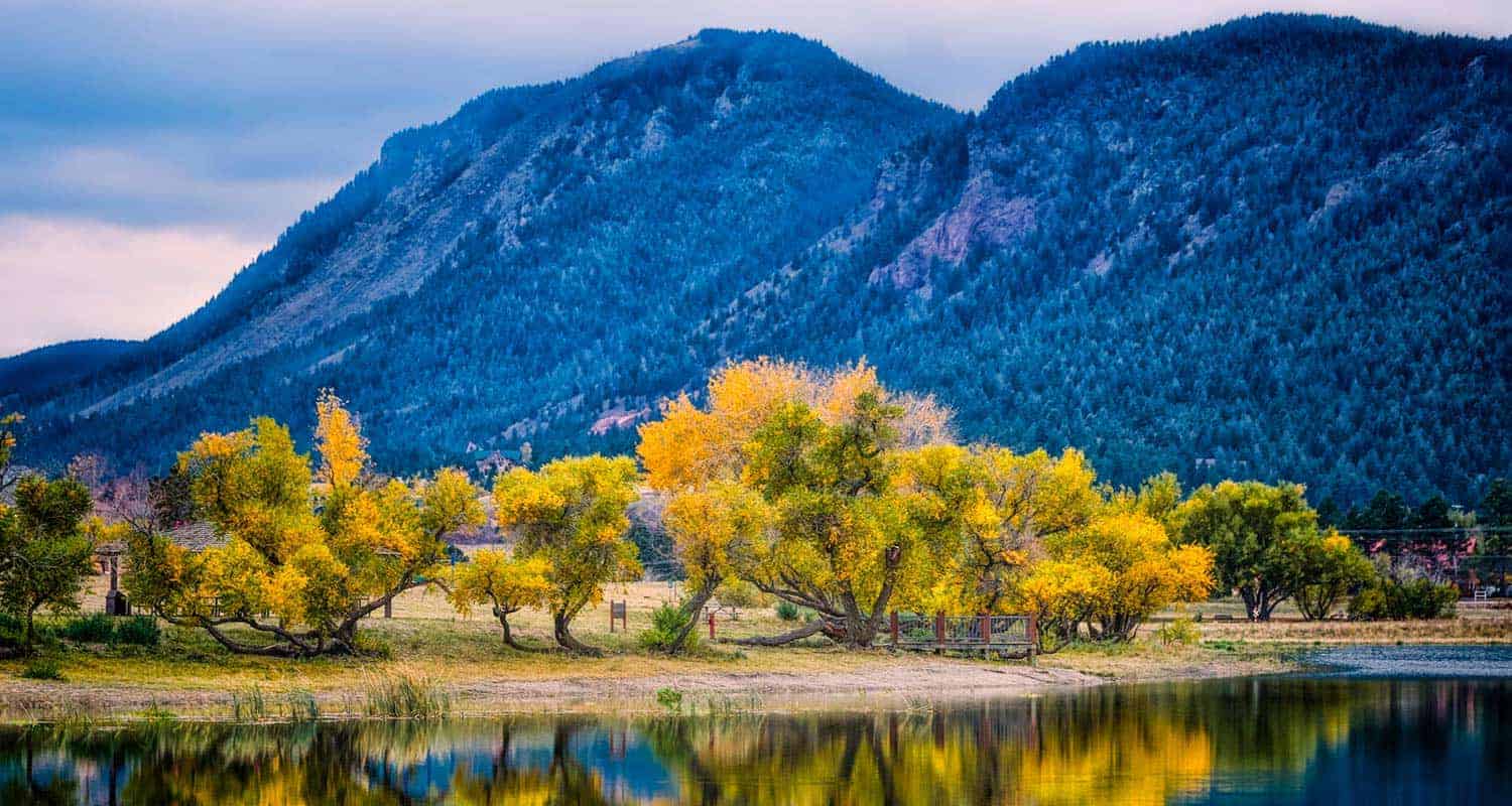
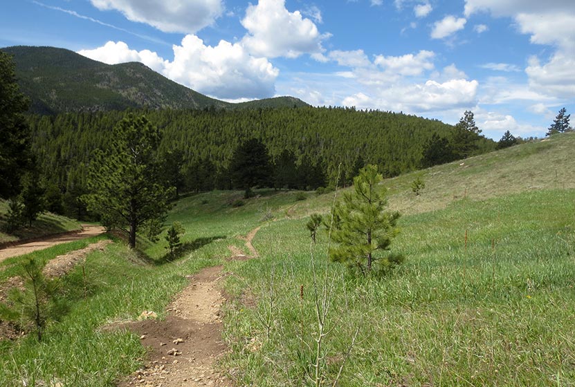
Santa Fe Regional Trail in Palmer Lake
The Santa Fe Regional Trail begins in Palmer Lake, Colorado, about 1 hour South of Denver. It's an easy trail with 17 miles from Palmer Lake to Colorado Springs along the old path of the Santa Fe Railroad. Explore the full Santa Fe Regional Trail hike profile below for trail map, driving directions, and more tips and details to help you enjoy this hike or bike adventure near Colorado Springs.
Trail Snapshot: Santa Fe Regional Trail
| Hike Distance | 1 to 17 miles one-way |
|---|---|
| Difficulty | Easy |
| Duration | Approx 1 hour+ |
| Trail Type | Out-and Back |
| Starting Elevation | 7200′ |
| Elevation Gain | Approx -900′ from Palmer Lake to Edmondson Trailhead |
| Seasons | Year Round |
| Dogs | Allowed On Leash |
| Hike Trail Map | Click for Trail Map of Santa Fe Regional Trail |
| Denver Drive Time | 1 hr |
| Driving Directions to Santa Fe Regional Trail Trailhead | Click for Google Map |
| Town Nearest Hike | Palmer Lake, Colorado and Colorado Springs |
| Beauty | Air Force Academy, Views of Pikes Peak |
| Activities | Hiking, Cycling, Trail Running |
Parking & Trailhead Information: Santa Fe Regional Trail
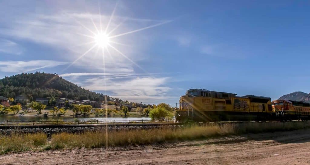
From Denver, take Interstate 25 south through Castle Rock and Larkspur, exiting onto County Line Road/Palmer Divide Road at exit 163, taking a right onto County Line Road. Stay on County Line Road for about 2.5 miles. Just before crossing the railroad tracks, the entrance to Palmer Lake Regional Recreation Area will be on your left. You'll see a sign and the first parking area. Drive past this parking lot to the larger lot. Here, at this south lot, you'll find restrooms, a playground, and the trailhead for the Santa Fe Regional Trail.
The Hike: Santa Fe Regional Trail
The Santa Fe Regional Trail begins in Palmer Lake and runs South for 17 miles where it merges with the Pikes Peak Greenway Trail. Because the trail follows the railroad grade of an abandoned railroad line, its relatively level, descending about 900 feet on its 17 mile course into Colorado Springs. This makes for a nice family bike ride, especially if you take two cars and drop a shuttle car off at the Edmondson Trailhead on the northern end of Colorado Springs. Here's a map link of both trailheads , and a link to the Edmondson Trailhead with driving directions from Denver.
North Trail Segment
In Palmer Lake, you have North and South hiking options. You can go North via the Santa Fe to Greenland Trail Link to pick up the Greenland Trail which winds through the wild green meadows and towering buttes south of Larkspur. That stretch from Palmer Lake to the Greenland Open Space Trailhead is 5.4 miles.
South Trail Segment
The South Trail segment of the Santa Fe Regional Trail runs through Palmer Lake and the town of Monument. Just south of Baptist Road the trail enters the Air Force Academy and runs parallel for a while with interstate 25. Then the trail makes a hard bend to the west, taking hikers and bikers away from the noise of the roads and winding
through into the draw of Monument Creek. It then bends its way behind (West of) the Air Force Academy airfield. This segment gives visitors a unique view of the Academy seen by few people. The trail then exits the Academy and enters the City of Colorado Springs. Just south of the Edmondson Trailhead, the Santa Fe Regional Trail merges onto the Pikes Peak Greenway.

Tips & Resources for Hiking Santa Fe Regional Trail
- TIP: Bike helmets are required on the Air Force Academy segment of the Santa Fe Regional Trail
- TIP: Be sure to pack the sunscreen because there is no shade on the trail.
- Trail Map: Santa Fe Regional Trail
- Packing List: Always pack the 10 Essentials. Download our Hiking Guide to get the list and dayhiking packing checklist.
- Colorado Road Conditions: Colorado Road Conditions
- Photo: We would like to express our gratitude to Christopher Rosenberger for sharing such an amazing photographs of this hike to in Palmer Lake.
- After the Hike: Rock House Ice Cream in Palmer Lake
Weather
Driving Directions
Map to Santa Fe Regional Trailhead
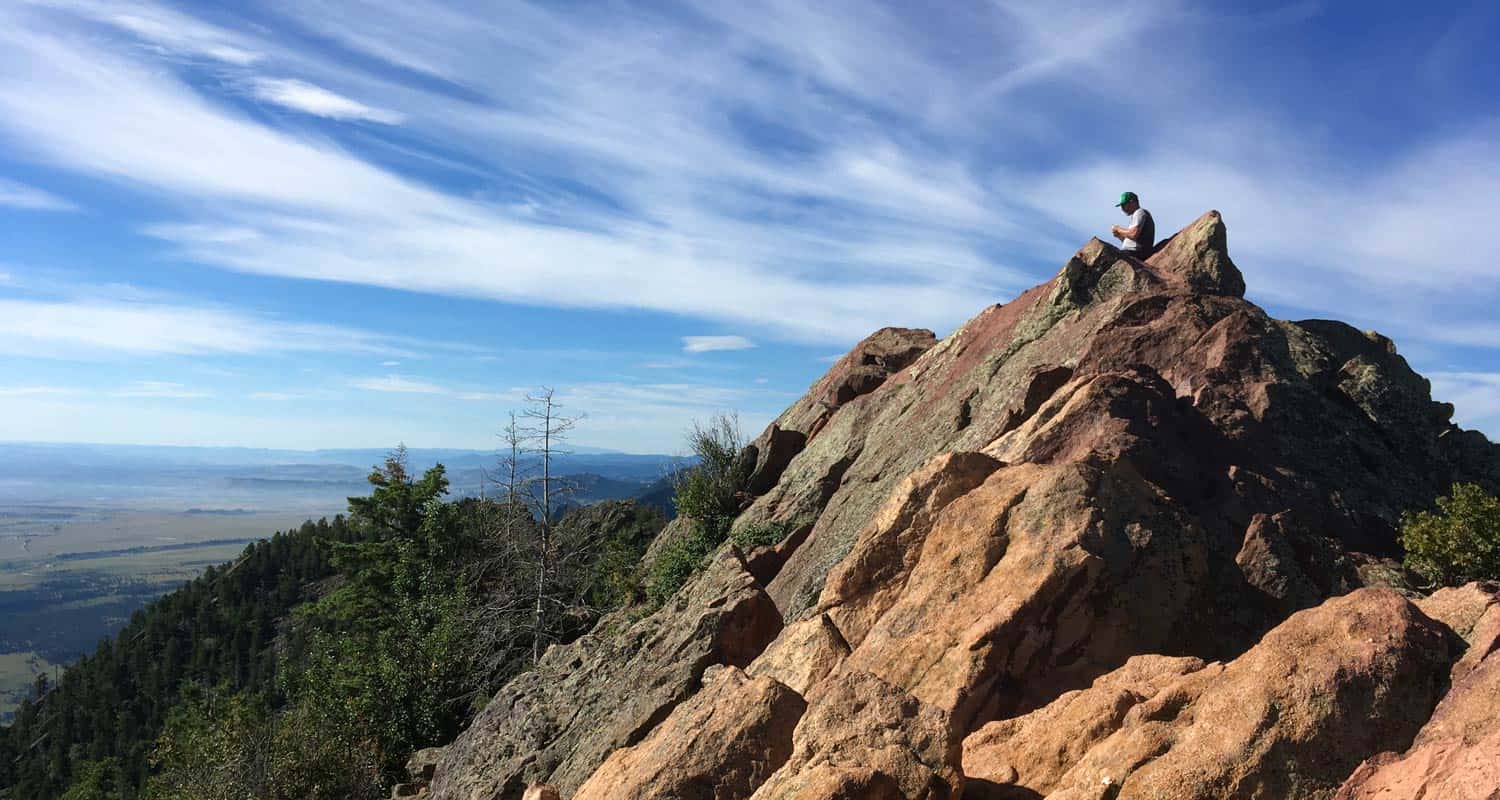
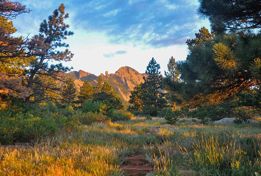
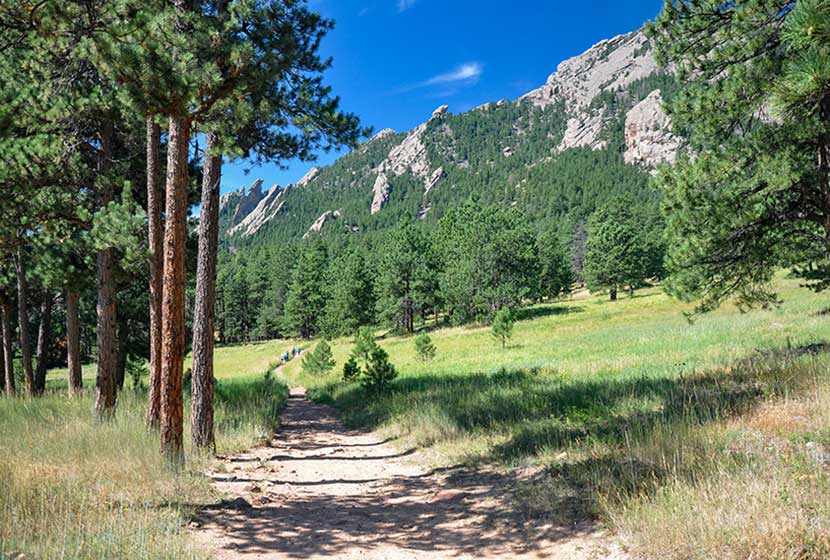
South Boulder Peak
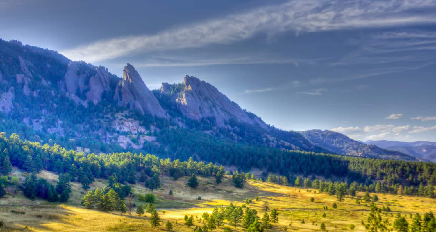
South Boulder Peak is a demanding 3.7-mile hike (one-way) situated above the South Mesa in the famous Flatirons region near Boulder Colorado. Hikers can bag nearby Bear Peak on the same trip and return via Fern Canyon to make an 8.7 mile loop. Explore the full South Bolder Peak hike profile below for the trail map, driving directions, and more tips and details to help you enjoy this adventure near Boulder, Colorado.
South Boulder Peak Trail Snapshot
| Hike Distance | 7.4 Miles Round Trip or approx. 8.7 Mile Loop |
|---|---|
| Difficulty | Difficult |
| Duration | Approx 3-5 hrs |
| Trail Type | Out and Back or Loop Option |
| Starting Elevation | 5650′ |
| Elevation Gain | Approx +2900′ South Boulder Peak 8550' |
| Seasons | Year Round |
| Dogs | Allowed On Leash |
| Hike Trail Map | Click for a Map South Boulder Peak and South Mesa Trailhead |
| Denver Drive Time | 45 Minutes |
| Driving Directions to South Boulder Peak via South Mesa Trailhead | Click for Google Map |
| Town Nearest Hike | Boulder, Colorado |
| Beauty | Peak Top Views, Canyon, Wildflowers, Sunrise, Meadows, Wildlife: Deer, Bear, Birding. |
| Activities | Hiking, Trail Running, Photography |
Parking & Trailhead Information for South Boulder Peak
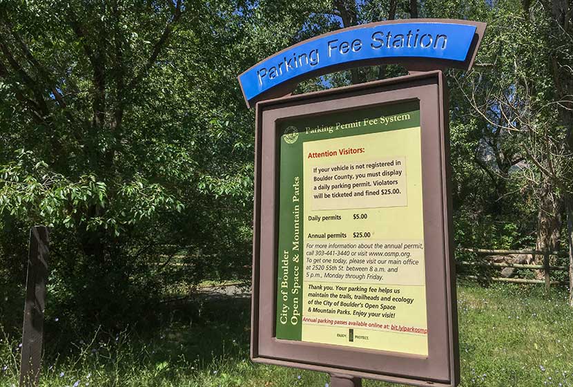
The trail to South Boulder Peak begins at the South Mesa Trailhead off of Eldorado Springs Drive just South of Boulder, Colorado. From Denver, drive North on interstate 25 to 36 toward Boulder. Take the McCaslin Blvd exit and then go South/West onto McCaslin. At the intersection of McCaslin and Marshall, take a right onto Marshall Road. Marshall will eventually intersect with Eldorado Springs Drive. Take a left onto Eldorado Springs Drive. About two miles down the road, you'll find the South Mesa Trailhead on the right. The South Mesa Trailhead is a part of the Boulder County Open Space and requires a daily parking fee, or an annual pass. I went online and bought an annual parking pass through the Open Space website. This gives you access to all the southern fee parking areas as well as the parking areas on Flagstaff Mountain. There are restrooms at the trailhead but not potable water.
The Hike: South Boulder Peak
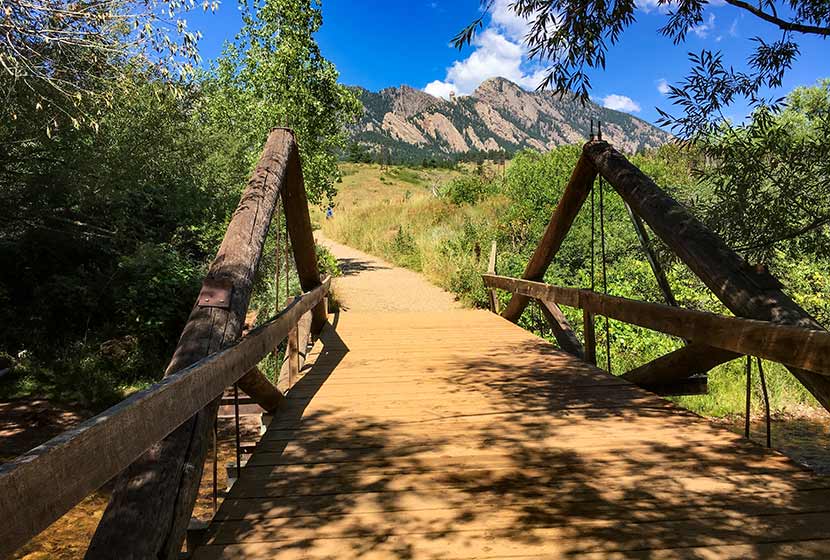
If you study a map of the South Mesa area, you'll notice that it's a complex network of trails. Tis is great for exploring the mesa, but when summiting a peak, you'll want to preserve as much energy as possible by taking the most direct route. The first trail choice presents itself after crossing the bridge over small bridge that spans Boulder Creek.
We took the Homestead Trail, a 1.3 mile segment to a connector segment of the Mesa Trail. It will be marked "Mesa Trail" and have an arrow pointing left to the Shadow Canyon Trail and Right to the Towhee Trail. The way to South Boulder Peak will be to head left toward Shadow Canyon. During this first segment, you'll gain great views down into the entrance of Eldorado Canyon .
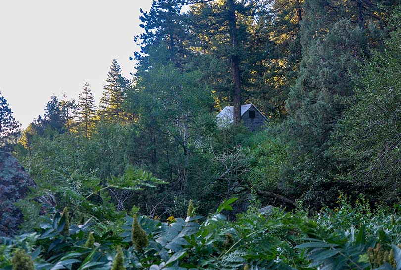
The first 0.4-mile segment of the Shadow Canyon South Trail is gradual. At any of the other trail intersections keep taking those marked "Shadow Canyon." Eventually, the trail leads into a densely wooded ravine where an old cabin is tucked away in the undergrowth
You'll know when you've entered Shadow Canyon because the trail becomes steep and demanding. It's more humid, too, so the rock can get slippery. Be mindful of your steps and prepared to ascend over a mile of fairly rugged terrain.
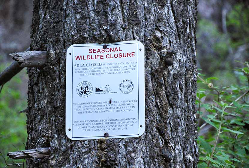
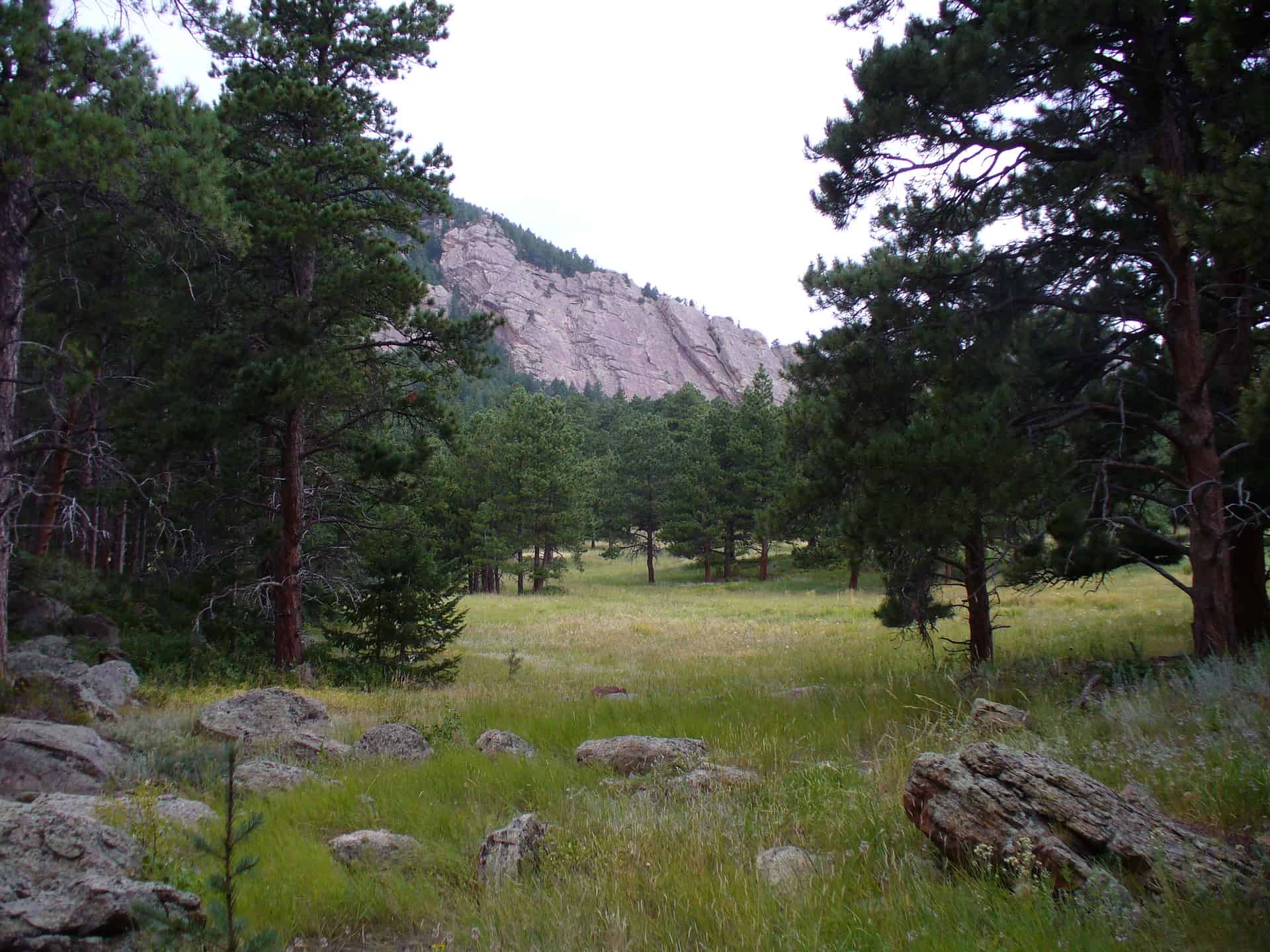
Shadow canyon is an access point for a prominent rock formation, Devils Thumb. Seasonal closures (see photo below) protect nesting raptors. Be sure to stay out of this area from Feb. 1st to July 31st. The Shadow Canyon Trail is not closed during this time, but refrain from going off-trail or taking social trails in the closure area during these periods.
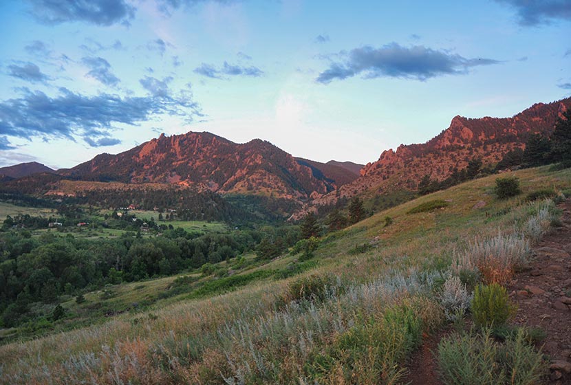
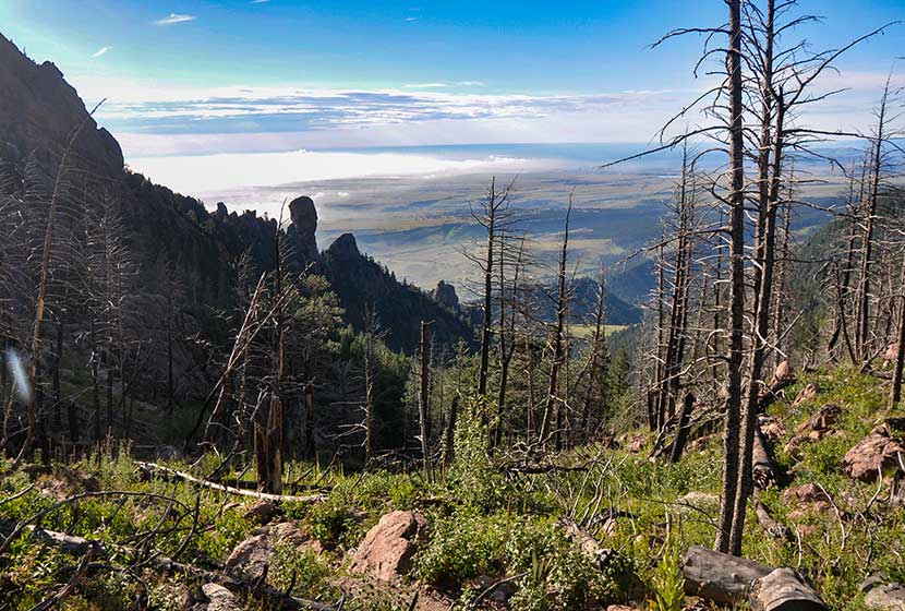
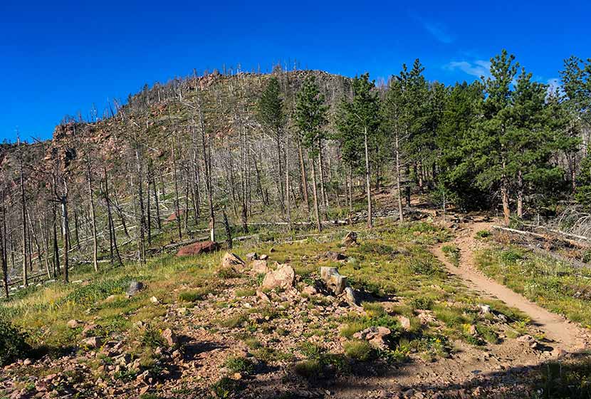
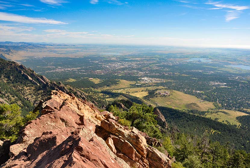
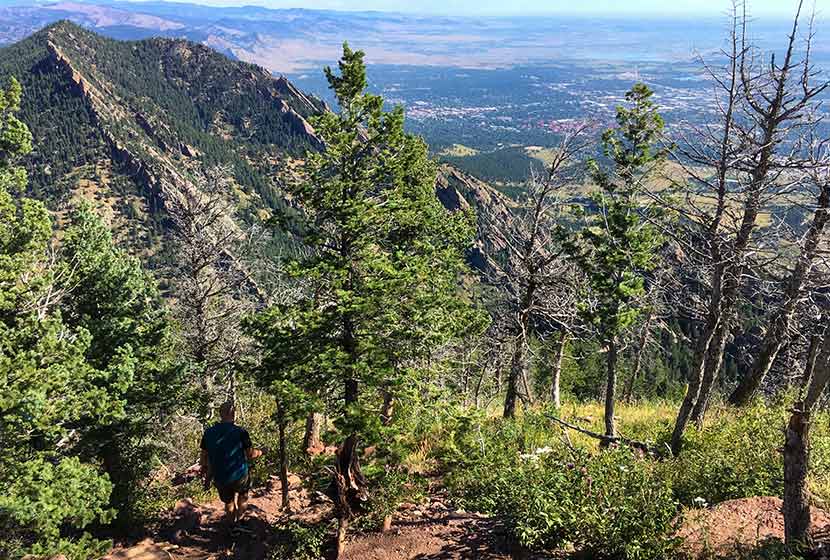
The trail pops out of the canyon onto saddle between South Boulder Peak and Bear Peak. The first thing you'll notice is a burn area that stretches all the way to the top of South Boulder Peak. It's the result of the 2012 Flagstaff fire.
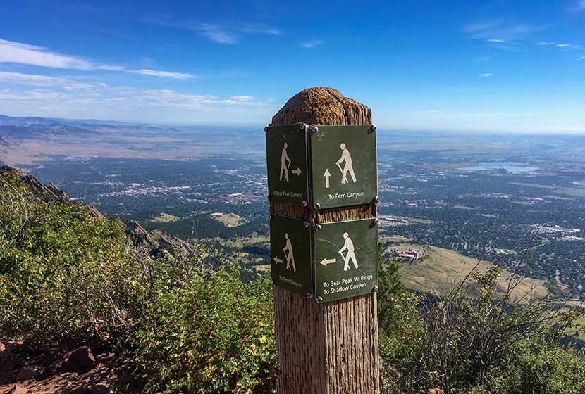
At the saddle ridge, another trail sign notes the way to South Boulder Peak, a 0.3 mile trail climbs to the summit. You'll notice that the trail to the right leads the same distance to Bear Peak.
At points, the trail becomes difficult to discern and requires a little bit of bouldering to make it to the top. Whenever I'm in these rocky segments, I try to be mindful of those behind me. It's easy to inadvertently cause a rock to shift and tumble toward the hikers below. Most of the rock is stable, but it's smart to be aware as you navigate these kinds of areas. The back side of the summit is exposed, so do not approach or descend the peak via this route. And be mindful of the exposure while on the peak.
The pink granite summit offers 360 degree panoramic views (see the video below).
You can also see the summit of Bear Peak just 0.6-mile to the Northeast. If you want to summit Bear Peak, be sure to review our Bear Peak Hike Profile.
From the summit of South Boulder Peak your options are to 1) Descend via the approach route (7.4 miles round trip), 2) Summit Bear Peak and return via the approach route (8 miles total), or 3) Summit Bear Peak and return via Fern Canyon (approx. 8.7 miles). It's important to know that the descent into Fern Canyon is more demanding than the return via Shadow Canyon. For the loop route via Fern Canyon, explore our Bear Peak Trail Profile.
Tips & Resources for Hiking to South Boulder Peak
- Hiking with Your Dog: Though dogs are allowed on leash, I wouldn't put South Boulder Peak on the dog-friendly list because of the rocky area at the summit and the ascent up fern canyon.
- TIP: Be ready for the hike down to be demanding on your knees and ankles, especially if you choose to descend via Fern Canyon. Trekking poles would be helpful.
- Weather: As with all hikes on the Front Range, especially peak hikes, be weather aware. Thunderstorms can emerge suddenly, especially in the early afternoon in the Summer months.
- Trail Map: South Boulder Peak Map from South Mesa Trailhead
- Packing List: Always pack the 10 Essentials. Download our Hiking Guide to get the list and dayhiking packing checklist.
- Colorado Road Conditions: Colorado Road Conditions
- After the Hike Cafe: Walnut Cafe in Boulder
- After the Hike Brewery: Sanitas Brewing Company
Weather
Map & Driving Directions
Click for Driving Directions

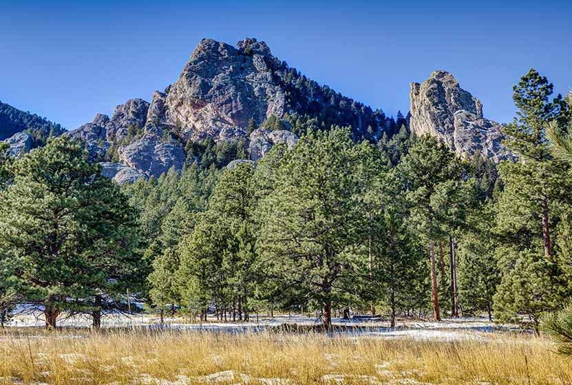
Bear Peak Near Boulder
Bear Peak is a demanding 7.4-mile hike (round trip) through the broad meadows of South Mesa, up through the rocky trail of shadow canyon, to the granite summit with sweeping 360 degree views of the Colorado Front Range. Hikers can summit South Boulder Peak on your way and make a loop hike out of your adventure by returning via Fern Canyon. Explore the full Bear Peak hike profile below for the trail map, driving directions, and more tips and details to help you enjoy this adventure near Boulder, Colorado.
Bear Peak Trail Snapshot
| Hike Distance | 7.4 Miles Round Trip or 8.4 Mile Loop |
|---|---|
| Difficulty | Difficult |
| Duration | Approx 3-5 hrs |
| Trail Type | Out and Back and Loop Option |
| Starting Elevation | 5650′ |
| Elevation Gain | Approx +2800′ Bear Peak 8461' |
| Seasons | Year Round |
| Dogs | Allowed On Leash |
| Hike Trail Map | Click for a Map Bear Peak and South Mesa Trailhead |
| Denver Drive Time | 45 Minutes |
| Driving Directions to Bear Peak from South Mesa Trailhead | Click for Google Map |
| Town Nearest Hike | Boulder, Colorado |
| Beauty | Peak Top Views, Canyon, Wildflowers, Sunrise, Meadows, Wildlife: Deer, Bear, Birding. |
| Activities | Hiking, Trail Running, Photography |
Parking & Trailhead Information for Bear Peak
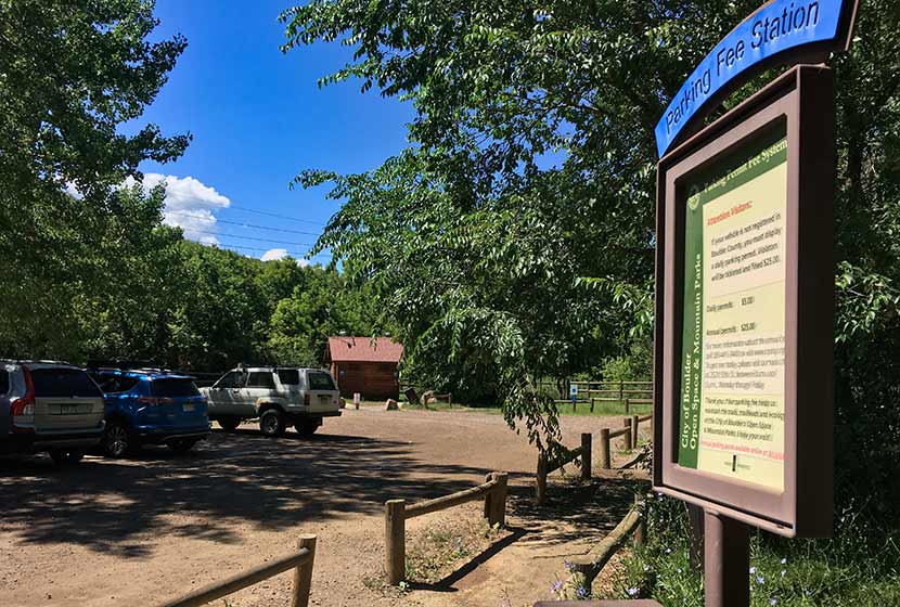
Access to Bear Peak is from the South Mesa Trailhead off of Eldorado Springs Drive just South of Boulder. From Denver, drive North on interstate 25 to 36 toward Boulder. Take the McCaslin Blvd exit and then go South/West onto McCaslin. At the intersection of McCaslin and Marshall, take a right onto Marshall Road. Marshall will intersect with Eldorado Springs Drive. Here, take a left onto Eldorado Springs Drive. About two miles down the road, you'll find the South Mesa Trailhead on your right. The South Mesa Trailhead is a part of the Boulder County Open Space and requires a daily parking fee, or an annual pass. I went online and bought an annual parking pass through the Open Space website. This gives you access to all the southern fee parking areas as well as the parking areas on Flagstaff Mountain. There are restrooms at the trailhead.
The Hike: Bear Peak
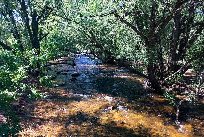
From the South Mesa Trailhead, the trail leads across a small bridge spanning over Boulder Creek. Willow trees arch over the stream making it worth a short pause to take in the sounds of water before you set off across the meadows of South Mesa. There are many trail options, but the most direct is to take the Homestead Trail, which heads West across a gentle grade toward Shadow Canyon.
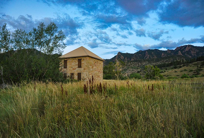
This first mile or so of the hike is easy and offers stunning views of the Flatirons and views of the entrance of Eldorado Canyon. An old stone building, part of an early homestead is the first marker you'll pass early in the hike.
After about 1.3 miles, the trail will split. Take the left (West) trail, which leads to the South Shadow Canyon Trail. After about a 1/2 mile, you'll encounter a 2nd trail split. The Shadow Canyon Trail will again bear to the left and begin heading up steeper terrain.
As the trail ascends, you soon leave the meadow and enter into more dense ponderosa pine forest. The vegetation in the understory grows tall and green at the entrance to the canyon. You'll see another cabin with a metal roof (pictured below). Soon past the cabin will be another important trail juncture. Again, the trail up Shadow Canyon will bear left (West).
Once in Shadow Canyon, the trail now becomes much more steep and requires navigating over rock and tree roots. This segment of the trail traveling up through the canyon is over a mile, so be ready for a steady and demanding climb.
The canyon is an access route for Devils Thumb, a prominent rock formation along this ridge. There are seasonal closures (see photo below) because of nesting raptors. Be sure to stay out of this area from Feb. 1st to July 31st. You are welcome to stay on the Shadow Canyon trail--it's not closed during this time--but refrain from going off-trail or taking social trails during this time up to Devils Thumb.
Eventually, the trail emerges from the canyon onto the saddle between South Boulder Peak and Bear Peak. This area is marked by a burn area, and in the late summer, raspberry plants grow trailside full of ripe berries. The burn was ignited by lightning in June of 2012. Named the Flagstaff Fire, it consumed about 300 acres before being contained by firefighters.
Another trail sign notes the way to Bear Peak, a 0.3 mile trail segment curving North up the back of the summit.
You'll notice more burn area on the left (West) side of the trail. The rock on the trail becomes increasingly brittle as you go, so be aware of those hiking below you and be sure to hike on the most secure and durable surfaces.
The final segment requires a scramble along about 25 yards of angled rock. Take your time and scope out the safest route to the summit. Most peaks along the Front Range have broad tops, but Bear Peak is tapered to a point with exposure on all sides. Several USGS markers are set into the rock (I think I counted 3--which is unusual). The views are great, both to the East and to the mountains in the West.
There are two options for the return hike: 1) to hike the 3.7 miles back through Shadow Canyon, retracing the same trails, or 2) to make a loop out of the hike by descending via Fern Canyon (about 4.7-mile return). The rest of this profile will follow the Fern Canyon to Mesa Trail return.
A sign marking the trail down Fern Canyon is located right at the base of Bear Peak (where the trail turns into a scramble up the summit). The descent into Fern Canyon is very steep and the rock is very loose. Hikers will also encounter people making their way up the trail, so be sure to move off to the side and grant right-of-way to hikers who are doing the harder work of ascending the trail. I would not recommend hiking up to Bear Peak from this route because the trail is way more demanding than the Shadow Canyon approach.
After about 1/2 of a mile descending this steep saddle, the trail will bear right (East) into Fern Canyon via a series of switchbacks. Eventually, the trail will emerge from Fern Canyon back onto the more gentle slopes of South Mesa. Look for signs for the Mesa Trail, and follow them South back to the South Mesa Trailhead.
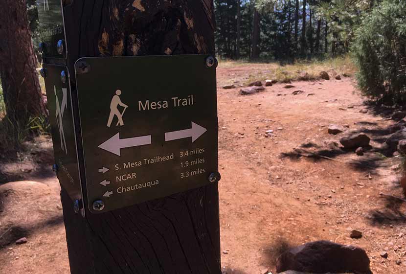
The hike back on the Mesa Trail travels in and out of the shade of Ponderosa pines and along the pink and orange Flatiron mountains that make this area so spectacular. We took the Upper Bluestem trail to some small connector trails leading back to the trailhead. Another approach is stay on the Mesa Trail (see map) until it connects back to the Homestead Trail.
Tips & Resources for Hiking to Bear Peak
- Weather: As with all hikes on the Front Range, especially peak hikes, be weather aware. Thunderstorms can emerge suddenly, especially in the early afternoon in the Summer months.
- Hiking with Your Dog: Though dogs are allowed on leash, and I've encountered people hiking with their dogs on the trails up to Bear Peak, I wouldn't put Bear Peak on the dog-friendly list because of the steep rock at the summit summit and the difficulty of the terrain leading up through the canyons.
- TIP: Be ready for a hike that is really demanding on your legs, especially the descent through Fern or Shadow Canyon. Trekking poles would be helpful on the descent.
- TIP: Hike to South Boulder Peak. It adds just 0.6 mile to your trip.
- Trail Map: Bear Peak Map from South Mesa Trailhead
- Packing List: Always pack the 10 Essentials. Download our Hiking Guide to get the list and dayhiking packing checklist.
- Colorado Road Conditions: Colorado Road Conditions
- After the Hike Cafe: Walnut Cafe in Boulder
- After the Hike Brewery: Sanitas Brewing Company
Weather
Map & Driving Directions
Click for Driving Directions

Shanahan Ridge Hike Near Boulder
The Shanahan Ridge Loop Hike is an easy, 4-mile lollipop-loop trail with stunning views of the Shanahan Ridge of the Flatirons in Boulder, Colorado. Explore the full Shanahan Ridge Loop hike profile below for trail map, driving directions, and more tips and details to help you enjoy this hike in Boulder.
Trail Snapshot: Shanahan Ridge Loop Trail in Boulder, Colorado
| Hike Distance | 4 Miles |
|---|---|
| Difficulty | Easy |
| Duration | Approx 2 hrs |
| Trail Type | Lollipop-Loop |
| Starting Elevation | Approx. 5500′ |
| Elevation Gain | Approx +900′ |
| Seasons | Year Round |
| Dogs | Allowed On Leash |
| Hike Trail Map | Click for a Map of Shanahan Ridge Trail |
| Denver Drive Time | 40 Min |
| Driving Directions to Shanahan Ridge Trailhead | Click for Google Map |
| Town Nearest Hike | Boulder, Colorado |
| Beauty | meadows, wildflowers, peak views, pine forest |
| Activities | Hiking, Photography, Trail Running |
Parking & Trailhead Information for Shanahan Ridge Loop Trail
The Shanahan Ridge Trailhead is located just along Lehigh Street south of Boulder. From US 36, follow Table Mesa Drive West to its intersection with CO 93. Turn left onto 93 and follow it for less than a mile. Turn right onto Greenbriar Boulevard which eventually becomes Lehigh Street. The trailhead is on the left/southwest side of the road and marked by a trail post and trash receptacle. There is actually no parking lot because the trailhead is located in a residential area. Because of this please exercise extra care and respect for the residents as you park along Lehigh or adjacent streets. Be aware of city parking signage.
The Hike: Shanahan Ridge Loop Trail
The Shanahan Ridge loop is best hiked clockwise in order to gain the best views of the Flatirons and surrounding countryside. Going left on the first junction will take you onto a connector trail that will next intersect with the South Fork Shanahan Trail. This trail begins with a gradual ascent which becomes more demanding. If you are acclimatized to the altitude and hike a fair amount, you'll find this segment easy; but beginner hikers and those of us who are not in the best of shape will find this a moderately demanding trail.
Continue on the South Fork Shanahan Trail for about 1.8 miles as it weaves through ponderosa forest and opens out to captivating vistas of the Flatirons. The trail will terminate at a junction with the Mesa Trail. Follow this trail North (right) as it winds along the base of the Shanahan Ridge of the Flatirons.
After approximately a 1/2 mile on the Mesa trail, it will intersect with the North Fork Shanahan Trail. Taking a right onto the North Fork Shanahan leads backdownhill for about 1.3 miles to the trailhead.

Tips & Resources for Hiking the Shanahan Ridge Loop
- TIP: Check ahead for trail closures.
- More Hikes in the Flatirons: Royal Arch Trail, First and Second Flatirons Hike, and Enchanted Mesa Hike.
- Trail Map: Shanahan Ridge Loop Trail
- Packing List: Always pack the 10 Essentials. Download our Hiking Guide to get the list and dayhiking packing checklist.
- Colorado Road Conditions: Colorado Road Conditions
- Photo: We would like to express our gratitude to Dave Dugdale and John Giez for sharing their photographs of this hike.
- After the Hike: The Parkway Cafe
Weather
Map & Driving Directions
Click for Driving Directions
Butler Gulch Hike
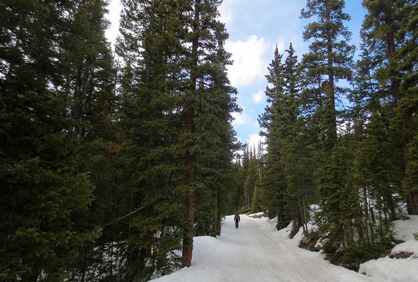
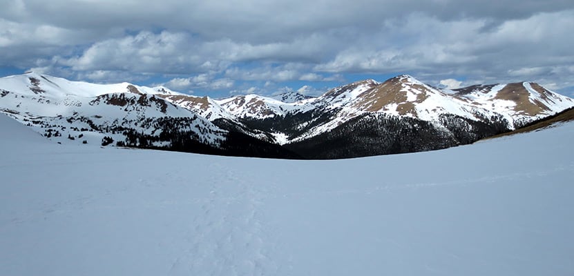
The Butler Gulch Trail near Berthoud Falls is a moderately difficult out-and-back trail with a balance of shade on the first half and then above treeline with spectacular views of peaks and wildflowers all around. Activities here include stream crossings and steep climbs, and one can visit an old mine above the treeline. This is also a great snowshoeing hike during winter and is a well-known skiing destination. Explore the full Butler Gulch hike profile below for trail map, driving directions, and more tips and details to help you enjoy this adventure near Berthoud Falls.
Trail Snapshot: Butler Gulch Hike
| Hike Distance | Approx 5 Miles Round Trip |
|---|---|
| Difficulty | Moderate (difficult in Winter) |
| Duration | Approx 3.5 hrs |
| Trail Type | Out and Back |
| Starting Elevation | 10,400′ |
| Elevation Gain | Approx +1200+′ |
| Seasons | June to September; October to May for Winter Trail Conditions |
| Dogs | Allowed On Leash |
| Hike Trail Map | Click for a Map of Bulter Gulch Trail |
| Denver Drive Time | 1 hr |
| Driving Directions to Butler Gulch Trailhead | Click for Google Map |
| Town Nearest Hike | Empire, Colorado |
| Beauty | Summer Wildflowers, Lake, Cascades, Meadows, Stream, Aspen trees, Wildlife: Mountain Goats |
| Activities | Hiking, Photography, Snowshoeing, Cross-country Skiing |
| Nearby Hikes | Herman Gulch and Cascades Near Berthoud |
Parking & Trailhead: Butler Gulch Hike
The Trailhead for Butler Gulch is about 1 hour West of Denver via Interstate 70. Take the exit for Hwy 40/Winter Park (easy to miss) through Empire (be alert for reduced speed limit) up to where US 40 makes a sharp bend to begin climbing up the mountain toward Berthoud Pass. Just before this turn, there is a left-hand turn to take for the Henderson Mine Road. Follow Henderson Mine road for about a mile. It will pass the mining operation and the parking area is just past the mine on the left. The main parking area is the first one you will encounter and it's large. A smaller one is about .25 mile up the road (the road is 4WD after the first lot) is small and fills fast. We recommend parking in the first lot as it is maintained and this will prevent damage to the trailhead.
From the parking area, hike the 4WD road for about 1/4 mile to where the trail splits. There should be signage here at the fork indicating the Jones Pass Trail goes to the right, and the Butler Gulch Trail goes to the left. Soon, the trail begins to climb through mixed forest of spruce, fir, and aspens. After approximately one mile, a mountain stream nears the trail, forming a quaint meltwater waterfall (right side of trail). Soon, the trail emerges from the trees into a landscape of snow-capped mountains. This bowl will be replete with wildflowers in the early weeks of Summer. At this point, hikers are exposed to the elements, and during the Summer months, lightning storms can come up without warning in the afternoon. So, keep an eye on the sky. Winter travelers should be alert to avalanche conditions. Here in the bowl, the trail has come to about 2.5 miles and a hike back will make this a 5-mile round-trip adventure. Hikers can add a strenous hike up the nearby ridgeline to gain panoramic views on the Continental Divide. When I hiked this in April of 2016, tracks were evident that led past the remains of old mining equipment along the ridge. At the top, the views are absolutely beautiful. It's a great place to take in hundreds of miles of changing aspen trees in the Autumn. The trail map link for Butler Gulch in this post is not the best. Because of this we recommend The Latitude 40 Summit County Trails Map.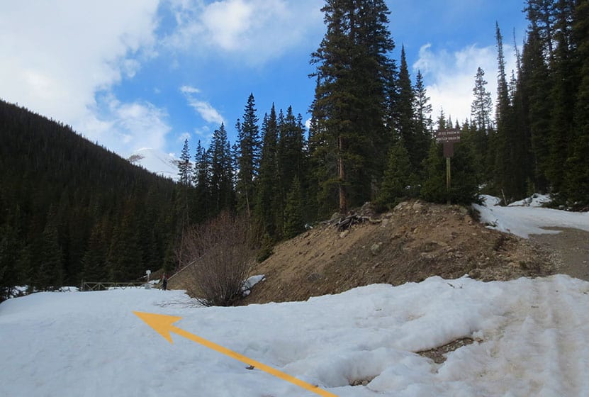
Tips & Resources for Hiking Butler Gulch Hike
Weather
Map & Driving Directions
Click for Driving Directions
Bear Canyon Loop Hike at NCAR
The Bear Canyon Loop Hike near Boulder, Colorado is a beautiful trail that spans wide open spaces and meadows near National Center for Atmospheric Research. The Bear Canyon Loop is a relatively easy 3.3-mile loop that features some of the best views of the Flatirons in Boulder. Explore the full NCAR Bear Canyon Loop hike profile below for trail map, driving directions, and more tips and details to help you enjoy this adventure near Boulder.
Trail Snapshot: Bear Canyon Loop Trail in Boulder
| Hike Distance | Approx 3.5 Miles |
|---|---|
| Difficulty | Easy |
| Duration | Approx. 2 hrs |
| Trail Type | Loop |
| Starting Elevation | 6080′ |
| Elevation Gain | Approx +400+′ |
| Seasons | Year Round with Winter Closures |
| For Closure Updates: | Boulder Open Space Closures |
| Dogs | Allowed On Leash |
| Hike Trail Map: | Click for a Map of Bear Canyon Loop |
| Denver Drive Time | 40 Min |
| Driving Directions to NCAR Trailhead | Click for Google Map |
| Town Nearest Hike | Boulder, Colorado |
| Beauty | Canyon, Creek, Wildflowers, Meadows, Wildlife: Mule deer |
| Activities | Hiking, Photography, Birding, Running |
Parking & Trailhead: Bear Canyon Loop Trail
The National Center for Atmospheric Research (NCAR) Trailhead is located about 40 minutes North of Denver. From Denver, follow U.S. Route 36 to Boulder. Take the exit for Table Mesa Drive and follow it West. It will wind through a neighborhood to the end as it winds through the neighborhood and past Bear Creek Elementary School. The road will turn into the Drive for NCAR which winds up and around to a large parking area at the lab.
The Hike: NCAR Bear Canyon Loop Trail
From the NCAR Parking area, hikers can pick up the NCAR trail just West of the main entrance to the building. The trail heads West, over a small ridge, past a water tank, then to a fork in the trail. Both the left and the right fork are considered the NCAR trail and both will lead to the Table Mesa Trail--but the left fork is shorter. At approximately 0.7-mile into the hike, the NCAR Trail will intersect with the Table Mesa Trail. Straight through takes hikers up on a 0.8-mile hike up to Mallory Cave, but for this loop hike, the correct way is to go left/South onto the Table Mesa trail. This first stretch provides some incredible views of the magnificent Flatirons Formations of Boulder. This trail segment heading south goes in and out of a forest grove, then the trail comes to its second important intersection.
At the Bear Canyon Trail intersection, take a left onto the Bear Canyon Trail which follows Bear Creek as it descends East. At about 1.5 miles into the hike, you'll encounter another fork. You can cut off about 1/4 of a mile of the trail by taking the left-hand segment. But the right-hand trail provides more pleasant scenery along the creek. The trail will near a neighborhood then bend to the North. This straight 0.7-mile stretch follows along the Eastern boundary of NCAR. Eventually, it meets up with the NCAR trail, which will lead back on a 1/2 mile stretch to the parking area.
Tips & Resources for Hiking the NCAR Bear Canyon Loop
- Wildlife Aware: Like many of the trails in the Boulder area, keep alert because mountain lions and black bears frequent the area. Know what to do if you encounter a Mountain Lion or a Black Bear.
- Trail Map: NCAR Bear Canyon Loop Trail
- Packing List: Always pack the 10 Essentials. Download our Hiking Guide to get the list and dayhiking packing checklist.
- Explore More Flatirons Hikes in Boulder: First Flatiron Hike, Gregory Canyon Hike, Green Mountain, Enchanted Mesa Hike, and Royal Arch Trail.
- Colorado Road Conditions: Colorado Road Conditions
- Photo: We would like to express our gratitude to Dave Dugdale for sharing such an amazing photograph of this NCAR Bear Canyon Loop Trail with a view of the Flatirons.
- After the Hike: The Parkway Cafe
Weather
Map & Driving Directions
Click for Driving Directions
Herman Gulch to Herman Lake Hike
The Herman Gulch Trail is one of the best summer wildflower hikes near Denver. It's also a challenging winter snowshoe and is often used for cross-country skiing. The Herman Gulch Trail is a 2.5 mile (one-way), out-and-back adventure into snowcapped mountain country and provides access to many more trails in Arapaho National Forest. Explore the full Herman Gulch hike profile below for trail map, driving directions, and more tips and details to help you enjoy this adventure in the Rocky Mountains of Colorado.
Trail Snapshot: Herman Gulch Hike, Colorado
| Hike Distance | Approx 5 Miles Round Trip |
|---|---|
| Difficulty | Moderate (Difficult in Winter) |
| Duration | Approx 3.5 hrs |
| Trail Type | Out and Back |
| Starting Elevation | 10,400′ |
| Elevation Gain | Approx +1600+′ |
| Seasons | June to September; October to May for Winter Trail Conditions |
| Dogs | Allowed On Leash |
| Hike Trail Map: Summer | Click for a Map of Herman Gulch Trail |
| Hike Trail Map: Winter | Click for a Map of Herman Gulch Trail |
| Denver Drive Time | 1 hr |
| Driving Directions to Herman Gulch Trailhead | Click for Google Map |
| Town Nearest Hike | Silver Plume, Colorado |
| Beauty | Summer Wildflowers, lake, cascades, meadow, mountain stream, aspen trees, wildlife: mountain goats |
| Activities | Hiking, photography, snowshoeing, cross-country skiing |
Parking & Trailhead Information for Herman Gulch
The Herman Gulch Trailhead is located about 20 miles west of Idaho Springs via I-70. From Denver, it's about a 60-minute drive but can take around 1.5 hours in winter ski traffic. The trailhead is located right off Exit 218 by taking a right onto Watrous Way. There are restrooms available at the trailhead. As with all trailheads, but especially those right off the interstate, be sure that your valuables are out of site and locked up. The trail is located in the middle of the parking area, just to the left of the restroom.
The Hike: Herman Gulch to Herman Lake
From the parking lot, the initial trail segment is steep. But be encouraged, while it's not an easy hike, the trail becomes more gradual as it gains elevation into the widening valley of Herman Gulch. At the trail intersection early in the hike, the trail to Herman Gulch will bear to the left, and a trail that leads to Waterous Gulch will lead to the right. Staying on the Herman Gulch Trail, it will weave in and out of the trees into small meadows with Herman Creek and many meltwater rivulets cascading across the landscape.

Winter may not release its grip on Herman Gulch until mid-summer. For example, all the photos in this trail profile were taken during the first week of June, so prepare for the snow to get increasingly deeper as you progress further on the trail. For this reason, we recommend trekking poles and traction devices for your boots. Also, be aware that at this elevation, thunderstorms often come up quickly on Summer afternoons, bringing dangerous lightning, especially in the open areas of the higher elevations. For this reason, and in order to avoid crowds, it's wise to begin your hike early in the day.
The trail eventually emerges from the trees into a broad alpine landscape where a series of rock cairns leads the way to Herman Lake. This final segment is steep and demanding. The lake is located in a wide bowl beneath the lofty reaches of Pettingell Peak. The lake may be snow-covered through much of June, depending on late-season snowfall. In the early and mid-summer, a series of small meltwater cascades make their way down along the western mountainside into the lake. Be sure to stay the trail as you will be in a fragile alpine ecosystem.
Hiking Herman Gulch in the Winter
Herman Gulch is also a popular snowshoeing and cross-country skiing destination. December to March offer the best snowpack for these activities. It's a very different experience when snow has piled up in Herman Gulch and it's even more critical that those venturing into this area have packed their 10 essentials and are dressed appropriately. There are two avalanche chutes on the right-hand side of the trail about 1 mile into the hike that hikers should keep in mind (see ORIC winter map). During this season, do not go above treeline into the higher reaches as these are very much prone to avalanches. It's also important to bear in mind that snowstorms can come up very quickly, even in Spring and Fall, reducing and even eliminating visibility. So be aware and be prepared. Snowshoeing travel speeds are about 1 mile per hour, depending on the person, which is half of hiking speeds. Adjust your travel times accordingly and for early darkness of winter.
Tips & Resources for Hiking Herman Gulch Hike
- TIP: As you ascend the valley in snow conditions, be cautious of 2 avalanche paths on the right.
- TIP: Before starting the a winter hike here, contact the Clear Creek Ranger District to inquire about snow conditions and trail updates.
- Trail Map - Summer: Herman Gulch Trail Summer
- Trail Map - Winter: Herman Gulch Trail Winter
- Packing List: Always pack the 10 Essentials. Download our Hiking Guide to get the list and dayhiking packing checklist.
- Colorado Road Conditions: Colorado Road Conditions
- After the Hike: Beaujos Pizza in Idaho Springs
Weather
Map & Driving Directions
Click for Driving Directions
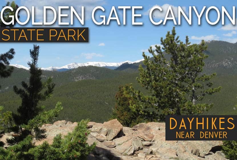
Golden Gate Canyon State Park Hiking Trails
6 Hikes in Golden Gate Canyon State Park
Located less than an hour from Denver and Boulder, Golden Gate Canyon State Park is a remarkable treasure. The park offers over 30 miles of hiking trails and some of the most accessible backcountry camping opportunities near Denver. Golden Gate is full of seasonal creeks and wildflowers, as well as promontories that open out to views of the snow-capped and lead-blue rock faces of the Rocky Mountains. The park is open year-round; however, during many years, snow may cover trails from as early as October through May. Explore this page to get familiar with several hike options and the camping facilities available in the Park.

Raccoon Loop Trail - Shaded and Family Friendly
Distance: 2.5 Miles
Difficulty: Easy
The Raccoon Loop Trail is an easy, 2.5-mile loop hike in Golden Gate Canyon State Park. Because it's short and has a variety of scenery, the Racoon Loop makes for an enjoyable hike for families. Most hikes near Denver are quite exposed to the sun, but this hike offers a good deal of shade. The trail boasts panoramic views of snow-capped peaks, glades of aspen trees, wildflowers, and seasonal brooks.
![]()

Blue Grouse Trail - A Short Adventure
Distance: 1.6 Miles Round Trip
Difficulty: Easy to Moderate
Blue Grouse Trail in Golden Gate Canyon State Park is another short hike of easy to moderate difficulty. If you are looking for a short adventure to gains views of green foothills and changing aspens, then this is for you. While not a spectacular hike, the Blue Grouse trail is easy to access and can be used as an access point to other trails and camping sites available in the park.
![]()

Forgotten Valley Hike - Homestead Ruins
Distance: 3 Miles Round Trip
Difficulty: Moderate
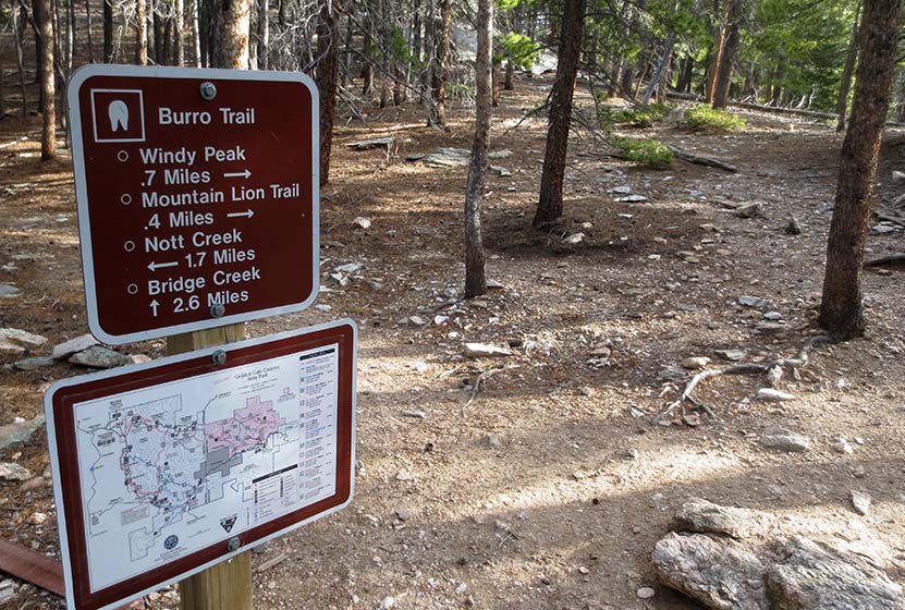
A favorite destination hike in Golden Gate Canyon State Park, hikers can put together a segment of the Burro Trail and Mountain Lion trail to access this old homestead and pond situated in Forgotten Valley. Nearby are several reservable campsites and a backcountry shelter, making this area a perfect place to camp before exploring the many miles of trails in the park.
![]()

Horseshoe Trail to Frazer Meadow
Distance: 3.6 Miles Round Trip
Difficulty: Moderate
Another trail to some of Golden Gate Canyon's camping areas, this out-and-back trail takes hikers through Greenfield Meadows and terminates at Frazer Meadow. Much of the trail follows alongside a seasonal creek that runs through the main valley. Aspen trees, meadows, wildflowers, and shaded trail segments are all highlights of this hike in the heart of the park.
![]()

Beaver Loop Trail
Distance: 2.8 Miles
Difficulty: Moderate to Difficult
The Beaver Loop trail can be picked up right from the visitor center at Golden Gate. It is a 2.8-mile loop with an out-and-back option of hiking over to Slough Pond. While it's a short hike, it requires about 1000' of elevation gain, making it a more demanding hike. Like so many of the hikes in Golden Gate, the Beaver Loop offers a beautiful panorama of distant, snow-capped mountains in the west.
![]()

Windy Peak Trail - A Great Vantage Point
Distance: 6.4 Miles
Difficulty: Moderate to Difficult
Another great destination hike, the way up to Windy Peak combines a few trails to create a loop hike with a spur trail leading to the top of Windy Peak. Windy Peak is an incredible vantage point for taking in the snow-capped Rockies and western skies. The eastern segment of this hike is replete with wildflowers during the summer.
![]()
Camping in Golden Gate Canyon State Park
Golden Gate Canyon offers a variety of camping options, making the park a great place for those new to backpacking to test their equipment and to get a feel for what a longer trip into the mountains might require. Families looking to try out camping for the first time can car-camp or hike short distances to some of the backcountry sites. All sites require reservation and a Colorado State Parks Pass. There are less demanding options such as cabins and yurts available. All sites, cabins, and campsites can be booked at the Colorado State Park's reservation page. Here's a quick overview of the camping options at Golden Gate Canyon State Park:
- 20 Backcountry Campsites: Brochure and Map of Backcountry Sites
- 5 Cabins: Located at Reverend's Ridge, no hike in required, year-round, max occupancy of 6, heated, electricity, water and restrooms nearby, showers available in Summer season
- 2 Yurts: Located at Reverend's Ridge, No hike-in required, year-round, max occupancy of 6, heated, electricity, water and restrooms nearby, showers available in Summer season
- 97 Campsites at Reverend's Ridge: No hike-in or short walk required, accommodates campers, trailers, and some RV spaces, limited sites available during Winter months, max occupancy of 6 per site, water and restrooms nearby, showers available in Summer season
- 35 Campsites at Aspen Meadows: Tent camping only, closed during Winter months, max occupancy of 6 per site, water pump and vault toilets
Weather
Map & Driving Directions
Click for Driving Directions
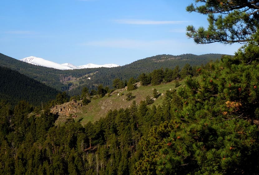
Windy Peak Hike in Golden Gate Canyon
Windy Peak is a summit hike in Golden Gate Canyon State Park. A moderate to difficult 6.4-mile loop hike that follows meltwater creeks, crosses green meadows replete with wildflowers, and offers great views at the summit of the snow-capped Rocky Mountains in the West. Explore the full Windy Peak Hike profile for trail map, driving directions, and many of the details you need to enjoy this adventure in Golden Gate Canyon State Park.
Trail Snapshot: Windy Peak in Golden Gate Canyon State Park
| Hike Distance | 6.4 miles Round Trip |
|---|---|
| Difficulty | Moderate |
| Duration | Approx 2-3 hrs |
| Trail Type | Lollipop-Loop with Spur to Summit |
| Starting Elevation | 7860′ |
| Elevation Gain | Approx +1300′ |
| Seasons | Best hiked May to October |
| Dogs | Allowed on 6' Leash |
| Hike Trail Map | Click for a Map of Golden Gate Canyon Trails |
| Denver Drive Time | 50 min |
| Driving Directions to Bridge Creek Trailhead | Click for Google Map |
| Town Nearest Hike | Golden, Colorado |
| Beauty | Panoramic views of snow-capped mountains, wildflowers, meadow, spruce, aspen |
| Activities | Hiking, photography, snowshoeing in winter, picnic area |
| Fee | Colorado State Parks Pass Required |
Parking & Trailhead Information for the Windy Peak Hike
From Denver, take US-6 West to Golden. Just outside Golden, US-6 will turn left (West) into Clear Creek Canyon; it's at this intersection that you'll continue North (not turning left) on 93. After 1.3 miles on 93, turn left onto Golden Gate Canyon Road. Now, prepare for the rest of your drive being pretty windy. About 4 miles down Golden Gate Canyon Road, you have the option of taking Crawford Gulch road to the Right or to stay on Golden Gate Canyon Road. Both routes will get you there.
I believe that Google Maps from Denver is going to default to Crawford Gulch Road. Do take your time and be alert for cyclists and motorcycles, especially on the weekend, as both Golden Gate Canyon Road and Crawford Gulch Roads are popular roads for riding. Eventually, Crawford Gulch Road will turn into Drew Hill Road, which runs through the heart of Golden Gate Canyon State Park. If you decide to take the Golden Gate Canyon Road option, it will intersect with Crawford Gluch/Drew Hill at the visitor center (on your right, just after the intersection on Crawford Gulch). If you take this route, the Bridge Creek Trailhead will be 2.3 miles down the road and on your left (north). One last thing to note is that Crawford Gulch Road has yet one more name, Ralston Creek Road. So, if you see that on any signage, just know you are on the right track.
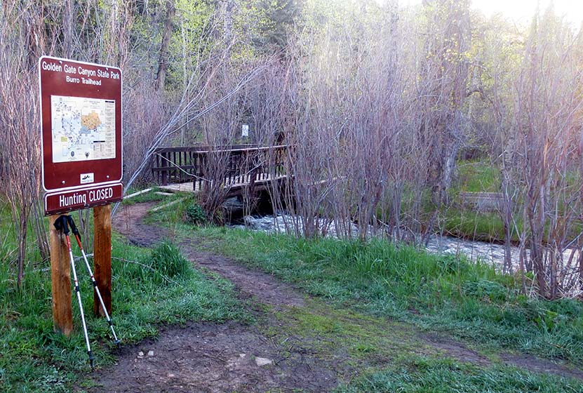
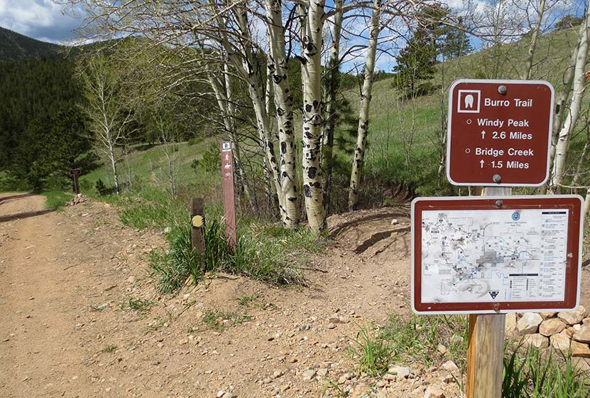
The Bridge Creek Trailhead is a bit unusual because it's composed of several parking areas along the on the north side of the road. However, all parking areas have trails that will lead hikers to the footbridge that crosses the trail and serves as the official start of the Burro trail and this hike. A sign (pictured above) reads "Burro Trailhead."
The Hike: The Windy Peak Hike in Golden Gate Canyon
This is a Lollipop-loop trail with a spur trail at the end that leads up to the summit. There are several trail junctions, which can make this the route a bit confusing. I've provided photos below of the trail junctions, but it's important to remember that weather can change the landscape and signage. The description here hikes the loop portion of the trail in a clockwise direction. We've classified this as moderate/medium in difficulty. However, its right on the edge because of the over 1000' elevation gain and more than 5 miles of trail. For some, this will be difficult. It's also on our list of dog-friendly hikes, but it's important to know that the peak is all rocky terrain that may be a bit tough on your dog's paws. As always, if you are taking your best friend, be sure to keep them on a leash out of respect for the wildlife, environment, and other hikers.
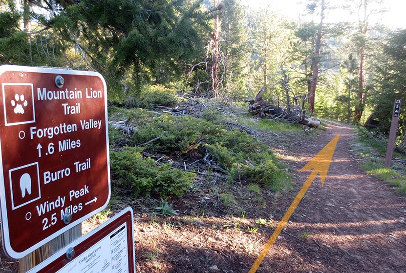
After crossing Ralston Creek, the trail makes its way up a gentle slope into the trees. At the first trail junction, stay on the Burro Trail (left). The second trail junction leads either straight on the Mountain Lion Trail to Forgotten Valley or right toward Windy Peak on the Burro Trail. The trail will make its way along a creek. Look for Calypso flowers, also called Pink Lady Slippers in this area. They grow along the creeks in Golden Gate Canyon State Park.
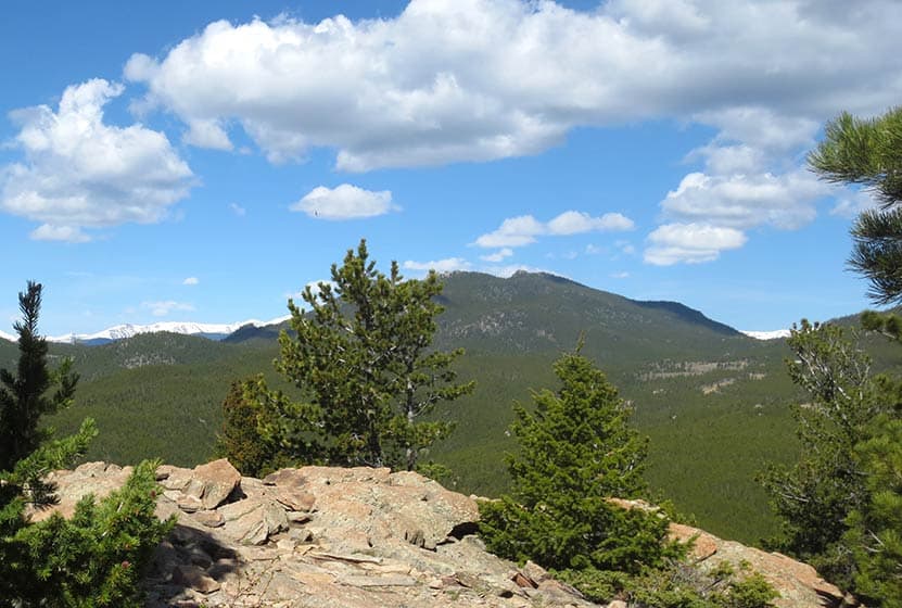
The loop begins at the third junction (pictured above), the way up to Windy Peak is clearly marked as the left-hand trail. From this point, it's 2.2 miles to the peak. Here the trail begins a steeper climb through an area with prominent chalk colored cliffs.

As you gain altitude, you'll gain views out to the Continental Divide rising above the green foothills of Golden Gate. The trail will then enter the shade of lodgepole forest.
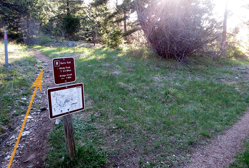
At the top of the loop, hikers will encounter the junction for the .7 mile spur trail that leads to the summit of Windy Peak (pictured below). There will be one more sign pointing the way at 0.4-mile below the summit.
The summit of Windy Peak is one of my favorite places to read and journal. Be sure to bring a picnic lunch with you, because you'll want to spend some time here resting and refueling for the hike back to the trailhead. The spur trail will lead back to the main Burro loop trail. At this point, you can return the way you hiked in to the spur trail (a slightly shorter way back), or continue on the rest of the loop toward Nott Creek. The landscape on this back end of the loop is riddled with wildflowers, so it's well worth doing the full loop hike.
The trail will weave its way down into a valley with a dirt service road. Here, hikers will want to follow the Burro trail towards the Bridge Creek Trailhead as it makes its way on and off the service roads.
The trail will work its way through a green meadow, then along Nott creek, following it West until retracing the trails that lead back to Bridge Creek Trailhead.
Tips & Resources for Hiking to Windy Peak
- TIP: Don't forget to bring food and water along this hike for refuelling.
- TIP: We advise picking up a paper map of Golden Gate Canyon State Park at the visitor center before embarking on this hike.
- Trail Map: Golden Gate Canyon Trail Map
- Packing List: Always pack the 10 Essentials. Download our Hiking Guide to get the list and dayhiking packing checklist.
- Colorado Road Conditions: Colorado Road Conditions
- After the Hike: Windy Saddle Cafe in Golden, Colorado
Weather
Map & Driving Directions
Click for Driving Directions to Bridge Creek Trailhead
Heil Valley Ranch Ponderosa Loop Hike
Heil Valley Ranch near Boulder offers this rewarding lollipop-loop hike which features views of distant snowcapped mountains and geological features unique to this section of Colorado. Nestled in the foothills between Boulder and Lyons this singletrack trail is a great destination for both hikers and mountain bikers. However, soil erosion has required occasional trail closures, so be sure to check out the Boulder County Open Space Twitter feed for trail conditions. Explore the full Heil Valley Ranch hike profile below for trail map, driving directions, and more tips and details to help you enjoy this adventure in the Boulder County, Colorado.
Trail Snapshot: Heil Valley Ranch Ponderosa Loop
| Hike Distance | 7.6 miles Round Trip |
|---|---|
| Difficulty | Moderate |
| Duration | Approx 4 hrs |
| Trail Type | Lollipop-Loop |
| Starting Elevation | 6000′ |
| Elevation Gain | Approx +1000′ |
| Seasons | Year Round |
| Dogs | Dogs Not Allowed |
| Hike Trail Map | Click for a Map of Heil Valley Ranch |
| Denver Drive Time | 50 min |
| Driving Directions to Heil Valley Ranch Trailhead | Click for Google Map |
| Town Nearest Hike | Boulder, Colorado |
| Beauty | Views to snowcapped peaks, unique geology, wildlife: deer, coyote, squirrel |
| Activities | Hiking, mountain biking, and photography |
Parking & Trailhead Information for Heil Valley Ranch Hike
From Boulder, follow US 36 West toward Lyons, turn left onto Left Hand Canyon Drive. After 0.7 mile, turn right onto Geer Canyon Drive. After approx. 1.2 miles, you'll come around a curve and see a sign for Heil Valley Ranch. The parking area is on the right/North side of the roach.
The Hike: Ponderosa Loop at Heil Valley Ranch Trail
There are two trails located at the north end of the parking area, the Wapiti and the Lichen. For this longer loop hike, we'll be taking the Wapiti up to the Ponderosa loop. This trail is found just to the left/west of the Lichen Loop trail. These should be well-marked by signs and the Lichen loop trail will immediately cross a footbridge. The Lichen loop is a great option for families with small children being just 1.3-mile loop with about 230' of elevation gain over the course of the hike.
Taking the Wapiti trail, hikers will head North through a broad valley punctuated with Ponderosa Pine. After passing an intersection with the Lichen Loop, the Wapiti will soon enter the shade of more ponderosa pines as it makes its way through more rocky and steep terrain. At 2.5 miles in, the Wapiti will meet up with the Ponderosa Loop Trail.
The Ponderosa loop segment offers a great set of views, beginning with views of snowcapped peaks in the west. We recommend taking the Ponderosa loop counter-clockwise, which will take you up to a high point then back down into a beautiful meadow with views all the way out to Left-Hand Reservoir. A second overlook is gained after this section, providing great views out to Indian Peaks Wilderness and Longs Peak in the North. The trail will meet back up with the Wapiti trail for a descent back to the trailhead.
Tips & Resources for Hiking the Heil Valley Ranch Trail
- TIP: Keep alert for mountain bikers as much of the trail is singletrack and a popular mountain biking area..
- Trail Map for Heil Valley Ranch Trail near Boulder: Trail Map Link
- Packing List: Always pack the 10 Essentials. Download our Hiking Guide to get the list and dayhiking packing checklist.
- Colorado Road Conditions: Colorado Road Conditions
- Photo: We would like to express our gratitude to Jonathan Reyes for sharing such great photographs of this hike at Heil Valley Ranch.
- After the Hike: The Parkway Cafe
Weather
Map & Driving Directions
Click for Driving Directions