The Herman Gulch Trail is one of the best summer wildflower hikes near Denver. It’s also a challenging winter snowshoe and is often used for cross-country skiing. The Herman Gulch Trail is a 2.5 mile (one-way), out-and-back adventure into snowcapped mountain country and provides access to many more trails in Arapaho National Forest. Explore the full Herman Gulch hike profile below for trail map, driving directions, and more tips and details to help you enjoy this adventure in the Rocky Mountains of Colorado.
Trail Snapshot: Herman Gulch Hike, Colorado
| Hike Distance | Approx 5 Miles Round Trip |
|---|---|
| Difficulty | Moderate (Difficult in Winter) |
| Duration | Approx 3.5 hrs |
| Trail Type | Out and Back |
| Starting Elevation | 10,400′ |
| Elevation Gain | Approx +1600+′ |
| Seasons | June to September; October to May for Winter Trail Conditions |
| Dogs | Allowed On Leash |
| Hike Trail Map: Summer | Click for a Map of Herman Gulch Trail |
| Hike Trail Map: Winter | Click for a Map of Herman Gulch Trail |
| Denver Drive Time | 1 hr |
| Driving Directions to Herman Gulch Trailhead | Click for Google Map |
| Town Nearest Hike | Silver Plume, Colorado |
| Beauty | Summer Wildflowers, lake, cascades, meadow, mountain stream, aspen trees, wildlife: mountain goats |
| Activities | Hiking, photography, snowshoeing, cross-country skiing |
Parking & Trailhead Information for Herman Gulch
The Herman Gulch Trailhead is located about 20 miles west of Idaho Springs via I-70. From Denver, it’s about a 60-minute drive but can take around 1.5 hours in winter ski traffic. The trailhead is located right off Exit 218 by taking a right onto Watrous Way. There are restrooms available at the trailhead. As with all trailheads, but especially those right off the interstate, be sure that your valuables are out of site and locked up. The trail is located in the middle of the parking area, just to the left of the restroom.
The Hike: Herman Gulch to Herman Lake
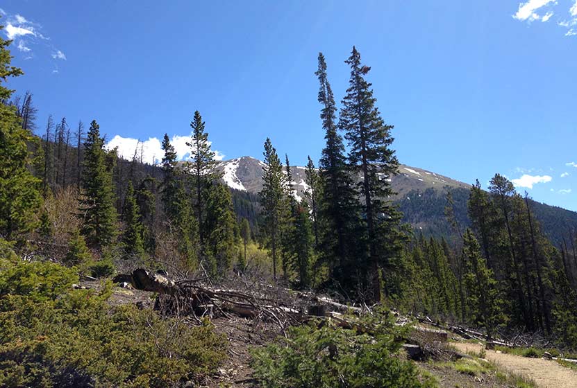
From the parking lot, the initial trail segment is steep. But be encouraged, while it’s not an easy hike, the trail becomes more gradual as it gains elevation into the widening valley of Herman Gulch. At the trail intersection early in the hike, the trail to Herman Gulch will bear to the left, and a trail that leads to Waterous Gulch will lead to the right. Staying on the Herman Gulch Trail, it will weave in and out of the trees into small meadows with Herman Creek and many meltwater rivulets cascading across the landscape.

Winter may not release its grip on Herman Gulch until mid-summer. For example, all the photos in this trail profile were taken during the first week of June, so prepare for the snow to get increasingly deeper as you progress further on the trail. For this reason, we recommend trekking poles and traction devices for your boots. Also, be aware that at this elevation, thunderstorms often come up quickly on Summer afternoons, bringing dangerous lightning, especially in the open areas of the higher elevations. For this reason, and in order to avoid crowds, it’s wise to begin your hike early in the day.
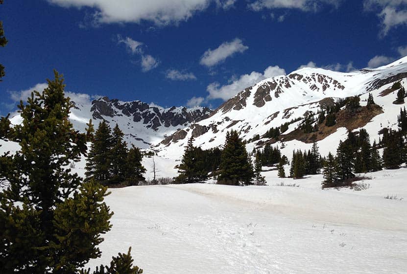
The trail eventually emerges from the trees into a broad alpine landscape where a series of rock cairns leads the way to Herman Lake. This final segment is steep and demanding. The lake is located in a wide bowl beneath the lofty reaches of Pettingell Peak. The lake may be snow-covered through much of June, depending on late-season snowfall. In the early and mid-summer, a series of small meltwater cascades make their way down along the western mountainside into the lake. Be sure to stay the trail as you will be in a fragile alpine ecosystem.
Hiking Herman Gulch in the Winter
Herman Gulch is also a popular snowshoeing and cross-country skiing destination. December to March offer the best snowpack for these activities. It’s a very different experience when snow has piled up in Herman Gulch and it’s even more critical that those venturing into this area have packed their 10 essentials and are dressed appropriately. There are two avalanche chutes on the right-hand side of the trail about 1 mile into the hike that hikers should keep in mind (see ORIC winter map). During this season, do not go above treeline into the higher reaches as these are very much prone to avalanches. It’s also important to bear in mind that snowstorms can come up very quickly, even in Spring and Fall, reducing and even eliminating visibility. So be aware and be prepared. Snowshoeing travel speeds are about 1 mile per hour, depending on the person, which is half of hiking speeds. Adjust your travel times accordingly and for early darkness of winter.
Tips & Resources for Hiking Herman Gulch Hike
- TIP: As you ascend the valley in snow conditions, be cautious of 2 avalanche paths on the right.
- TIP: Before starting the a winter hike here, contact the Clear Creek Ranger District to inquire about snow conditions and trail updates.
- Trail Map – Summer: Herman Gulch Trail Summer
- Trail Map – Winter: Herman Gulch Trail Winter
- Packing List: Always pack the 10 Essentials. Download our Hiking Guide to get the list and dayhiking packing checklist.
- Colorado Road Conditions: Colorado Road Conditions
- After the Hike: Beaujos Pizza in Idaho Springs
Weather
Map & Driving Directions
Click for Driving Directions


Just hiked Herman Gulch to the lake today. Beautiful hike–and not one where you have to hike to the end to reap the views. Great views so even if hike is too long for someone in your group, they will still experience the beauty. We did hear I-70 for the first short bit of the hike but don’t let that stop you. It disappears quickly and is very pretty. 3 of us did the hike in gym shoes and that was fine except a small stretch coming down where the loose scree made it a little slide-y. Hiking poles on the way down were helpful but definitely not a necessity by any means. I worked hard on the way up and felt my glutes but would still rate the hike as moderate. It is doable (I’m 53). It took us one hour 38 minutes to reach the lake. We were slower on the way down as my daughter’s knees were bothering her a bit so it was an hour and 45 minutes down for a total of 3 1/2 hours total. My phone app clocked the distance at 7.59 miles. Still some wildflowers (8-7-18). Trail was mostly dry but a few weeks ago I’m guessing some spots would have water. If you go, you’ll love the hike. It is immediately off of I-70 so easy on/off.
Nearly 7 miles round trip. Don’t get fooled by trail runners completing the leg to the lake in 1 1/2 hrs. 3 miles uphill with nearly 2/3 of fairly strenuous uphill climb. The top third has a lot of tree roots to deal with on the way down. Most people would do this in 4-5 hours out and back with lunch at the lake.
I did this one a few days ago w/ my husband. Overall it was a fantastic hike. A long stretch wove back and forth between wooded areas (shady, cooler) and meadows (full sun, hotter) — I really liked that. The first half-mile was steep and another half-mile toward the end was also steep, otherwise it’s not terribly strenuous. I wish we’d gone a week or two earlier, though, because in early August some of the wildflowers were already starting to wilt. I did not see a moose (was hoping to!) but I did see plenty of birds and chipmunks. And I’m pretty sure I spotted a marmot (on the narrower trail that goes beyond the lake), though by the time I saw him he was darting away from us. :) I’ve only done a handful of hikes, but this one is my favorite so far.