Forgotten Valley Hike at Golden Gate State Park
Can you think of a more mysterious name for a hike? Colorado's Golden Gate State Park has many trails, and the Forgotten Valley is a great place to start discovering this gem that is tucked between Golden and Boulder, Colorado. Get all the details on hiking the Forgotten Valley by scrolling down to the hike snapshot and hiking tips below.
Trail Snapshot: Forgotten Valley Hike at Golden Gate State Park
| Hike Distance | 3 miles Round Trip |
|---|---|
| Difficulty | Moderate |
| Duration | Approx 2.5 hrs+ Round Trip |
| Trail Type | Out and Back |
| Seasons | Spring through Fall |
| Dogs | Allowed On Leash |
| Hike Trail Map | Click for a Map of Golden Gate State Park |
| Denver Drive Time | 55 min |
| Driving Directions to Forgotten Valley Hike at Golden Gate State Park | Click for Google Map |
| Town Nearest Hike | Golden, Colorado |
| Beauty | Pond, old homestead ruins, wildlife: mule deer, golden eagle, Abert's squirrel, Steller's jay |
| Activities | Hiking trails, fishing, backcountry camping, visitors center |
| Park Fee Required | Click For Info |
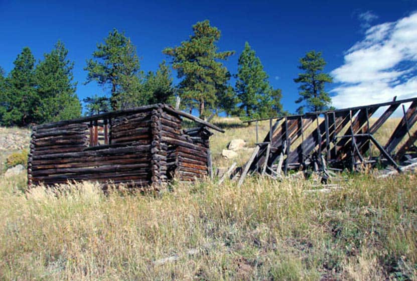
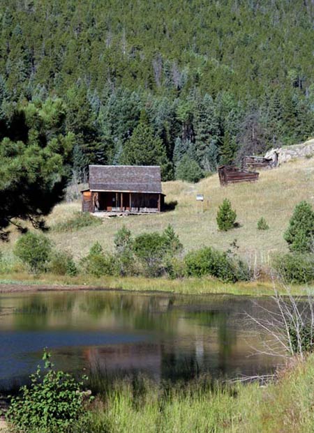
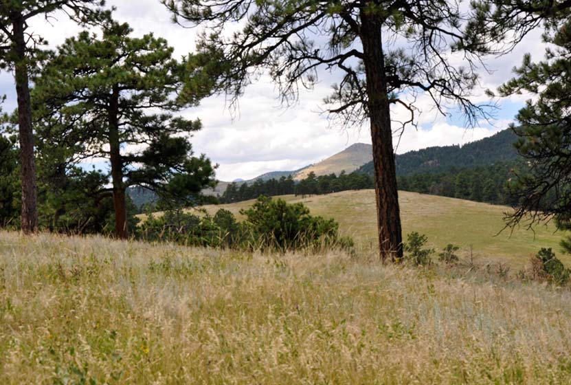
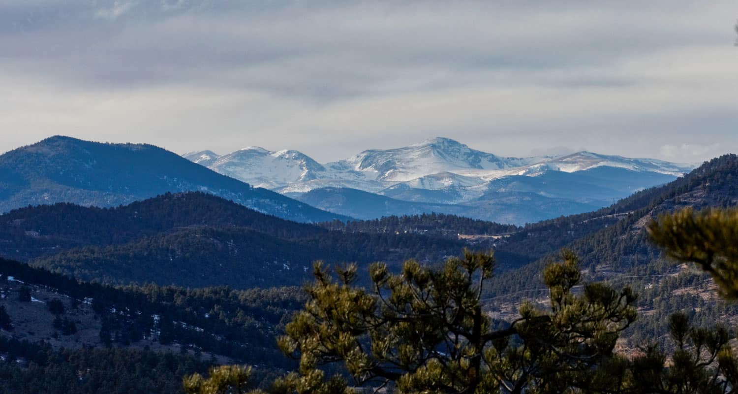
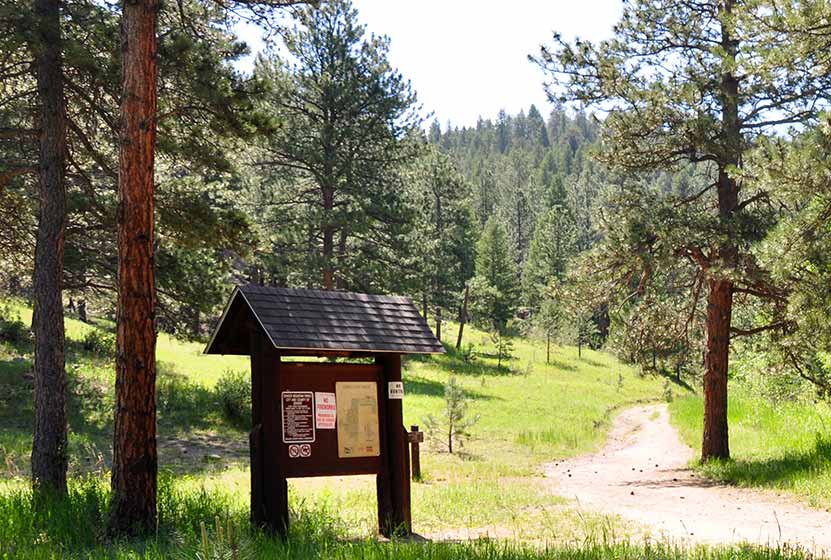
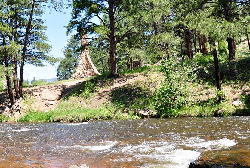
The Forgotten Valley in Golden Gate Canyon State Park is a step back in time.This day hike near Denver takes you 1.5 miles to an old homestead complete with front porch views of the small lake that sits in the bottom of the valley. From the Bridge Trailhead, take the Burro Trail for approximately 3/4 of a mile to where it intersects with the Mountain Lion Trail. Turn North (Left) on the Mountain Lion Trail, and follow that for about 3/4 of mile to Forgotten Valley and the Tallman Homestead. The pond in the valley is stocked by the division of wildlife. We want to thank Kenny Chaffin for his photo of the Tallman Homestead. You can view more of his Denver area photos here.
Tips & Resources for Hiking Forgotten Valley Hike at Golden Gate State Park :
- TIP: Pick up a Trail Map at the Golden Gate Canyon State Park Visitors Center.
- TIP: Parking at the Bridge Trailhead is very limited, so go early.
- TIP: There are some great options on this hike. Grab a Trails Illustrated Boulder/Golden Map and hike to the top of nearby Windy Peak or hike the entire Mountain Lion Trail Loop.
- Trail Map for Golden Gate Canyon State Park: Trail Map Link
- Colorado Road Conditions: Colorado Road Conditions
- After the Hike: Windy Saddle Cafe
Weather
Map & Driving Directions
Click for Driving Directions

Chicago Lakes Hike Near Mt. Evans
Want to take in some of Colorado's breathtaking scenery and put some miles under your hiking boots? The Chicago Lakes hike begins at Echo Lake. You'll pass three more mountain lakes as you punch up into the high country of Colorado's Mt. Evan's Wilderness. Explore the full trail profile below for the Chicago Lakes which includes driving directions, map, and tips.
Trail Snapshot: Chicago Lakes Hike Near Idaho Springs, Colorado
| Hike Distance | 8.4 to approx 10 miles RT |
|---|---|
| Difficulty | Difficult |
| Duration | Approx 5-7hrs |
| Trail Type | Out and Back |
| Elevation Gain | Approx +1200′ |
| Seasons | Summer to Fall |
| Dogs | Allowed On Leash |
| Hike Trail Map | Click for a Map of Chicago Lakes |
| Denver Drive Time | 1 hr |
| Driving Directions to Chicago Lakes Trail | Click for Google Map |
| Town Nearest Hike | Idaho Springs, Colorado |
| Beauty | Lakes, Mountain Peak Views, Creek, High Country, Cliffs, Wildflowers, & Wildlife: Mountain Goats, Bighorn Sheep, Elk |
| Activities | Hiking, wildlife viewing |
| Weather for Mt. Evans | Click Here |
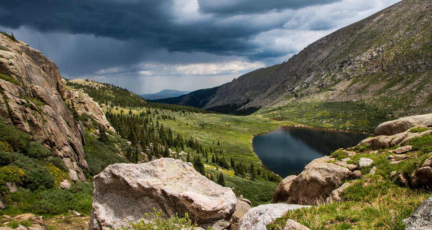
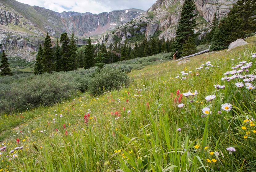
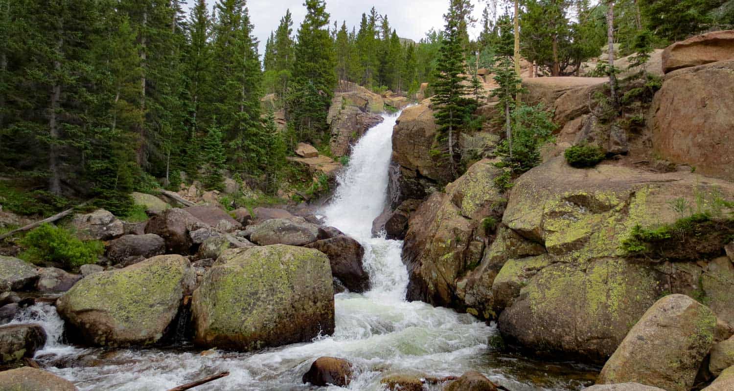
Looking for amazing views and some high mountain lakes near Denver? This challenging hike takes you to two high mountain lakes with amazing views of the Mt. Evans Wilderness area. Both lakes can be fished, as well as the lower Idaho Springs Reservoir that you pass on your way. We are not into giving long trail descriptions on Dayhikes Near Denver, but we'd suggest you read the basic one below and check out the trail description and pdf Chicago Lakes map link in the trail profile below.
The Chicago Lakes Trailhead and Trail: Park at the Echo Lake lot, where you'll find the sign for Chicago Lakes Trail 52 on the west side of the lake. That will lead you to another sign about .5 mile later directing you to the trail. The trail will turn into Idaho Springs Reservoir Road, then will return to a normal trail. It climbs through a burn area, the result of a fire in the 1970s, then continues to climb to Lower Chicago lake. The trail has a lot of character: steep areas, massive cliff walls, and expansive meadows. The trail continues, faint at times, up a steeper section to Upper Chicago Lake.
As you'll see in the comments on this hike, people come back with different trail lengths. So, to clear this up: Beginning at Echo Lake, the trail is 4.24 miles one-way to the lake. However, most people don't want to stop there, many continue on to the upper lake, which adds and additional .6 mile to the trail. Then, some people opt to hike around the lake, which adds to the hike as well. You may want to start early, especially in the Summer months so that you have the time to explore and to avoid our famous, afternoon Colorado thunderstorms.
Tips & Resources for Hiking Chicago Lakes Near Mt. Evans, Colorado :
- TIP: Don't Miss: 1 - The Upper Lake & 2 - The Cascade between the two lakes
- TIP: Check the Weather before heading up. Use the following link to National Weather Service page for Mt. Evans
- TIP: Look Over trail descriptions from Deb Stanley & David Day before heading out.
- Trail Map for Chicago Lakes Near Mt. Evans: Trail Map Link
- Colorado Road Conditions: Colorado Road Conditions
- After the Hike: Finish your hike by enjoying a slice of Barbara Day's famous pie at Echo Lake Lodge
- Photo: We would like to express our gratitude to Shea Oliver for sharing such an amazing photograph of this hike.
Weather
Map & Driving Directions
Click for Driving Directions

Canyon Loop Trail - Betasso Preserve, Boulder
This hike at Betasso Preserve near Boulder, Colorado makes for a perfect evening escape to watch the sunset over the town below. You'll cross through meadows dotted with wildflowers then under stands of Ponderosa pine that eventually open up to views to east. Explore the hiking trail profiles and map link below for details.
Trail Snapshot: Canyon Loop Trail at Betasso Preserve
| Hike Distance | 3.3 Miles |
|---|---|
| Difficulty | Moderate |
| Duration | Approx 1.5 hr |
| Trail Type | Loop |
| Seasons | All Season |
| Dogs | Allowed on Leash |
| Hike Trail Map | Click Here for a Trail Map |
| Denver Drive Time | 50 min |
| Directions | Click for Google Map |
| Town Nearest Hike | Boulder, Colorado |
| Beauty | Views of Boulder, Wildlife: Aberts Squirrel & Deer, Ponderosa Forest, Meadows |
| Activities | Picnic Area, Horseback Riding, Mountain Biking, Hiking Trails |
Tips & Resources for Hiking the Canyon Loop at Betasso Preserve :
- Easier Approach: Make your hike at Betasso Preserve a bit easier by starting from the East Trailhead
- Mountain Bikers: Each month the direction of travel required for Mountain Bikers is switched. Check the sign at the trailhead. Additionally, biking is not allowed on Wed. & Sat.
- Hikers: Check the sign at the trailhead as well and try to hike the opposite direction of the bike traffic.
- Trail Map for Betasso Preserve: Trail Map Link
- Colorado Road Conditions: Colorado Road Conditions
- After the Hike: Ozo Coffee in Boulder
Weather
Map & Driving Directions
Click for Driving Directions

Alberta Falls Hike at Rocky Mountain National Park
Colorado's Rocky Mountain National Park is full of waterfalls and this hike takes you to one of the most accessible waterfalls in the park. Alberta Falls is one of the most popular, short destination hikes in the park, and for good reason. If you only have time for one short hike on the East Side of RMNP, this is a great choice. To get to Alberta Falls, park at the Bear Lake Trailhead (see google directions below), then follow the signs south for Glacier Gorge and Alberta Falls. The waterfall is .8 miles down the trail from the parking area, make this a 1.6 mile out-and-back hike. Start early and hike the full 2.8 miles of trail in to stunning Mills lake inside Glacier Gorge.
Note: Rocky Mountain National Park now requires timed entry permits from May 27th through October 10th. See the RMNP permits page for more information.
| Hike Distance | 1.6 miles Round Trip |
|---|---|
| Difficulty | Medium |
| Duration | Approx 1 hr |
| Trail Type | Out and Back |
| Seasons | Spring thru Fall |
| Dogs | Prohibited in the Park |
| Hike Trail Map | Click Here for a Trail Map |
| Denver Drive Time | 2 hrs |
| Driving Directions to Alberta Falls, Colorado | Click for Google Map |
| Town Nearest Hike | Estes Park, Colorado |
| Beauty | Sub-Alpine Lake, Mountain Views, Wildlife: Abert's Squirrel, Elk, Bear |
| Activities | Picnicking, Hiking Trails, Snowshoeing |
| Fee | Park Pass Required |
Tips & Resources for Hiking to Alberta Falls
- Visitors and Vacationers: Alberta Falls is a great place to take visiting family and friends because it's not too difficult, and you have a lot of options if you want to explore the park
- Bring a Lunch: Getting this far into the park, even just driving, is quite a trip from the outside world. We suggest packing a lunch so that you can stay longer. And food just tastes better outside anyway.
- Trail Map for Bear Lake Corridor: Trail Map
- Rocky Mountain National Park Maps: Maps Link
- Colorado Road Conditions: Colorado Road Conditions
- After the Hike: Poppy's Pizza
 Looking for more waterfalls near Denver? Explore our more than 50 Colorado Waterfall Hikes, our favorite Waterfall Hikes in Rocky Mountain National Park, or 7 Waterfalls within One Hour of Denver.
Weather
Map & Driving Directions
Click for Driving Directions
Maxwell Falls Near Evergreen, Colorado
The Maxwell Falls hike is our most popular hike near Denver. Why? Because it's a perfect Colorado family hike with a variety of terrain, and it takes you to one of the closest waterfalls to Denver. Below, you'll find three different hike options: a one-mile hike, a three-mile loop, and a four-mile trek--all taking you to Maxwell Falls.
IMPORTANT NOTES:
#1: While this is a moderate hike, a significant number of novice and unprepared hikers have found themselves in challenging circumstances while hiking these trails: dehydration, heat exhaustion, altitude sickness, etc., and have had to call for emergency and rescue services. Evergreen Fire and Rescue urges novice and out-of-town hikers to seriously consider your fitness level before attempting the hike, to wear shoes that will help you navigate loose gravel, and to pack water for your trip.
#2: In the last few years, Maxwell Falls has become one of the most popular destination hikes near Denver, and it's having a negative impact. In other words, Maxwell Falls is being loved to death. Please read through the Help Care for Maxwell Falls segment for basic trail etiquette that will help protect this beautiful place.
Trail Snapshot: Maxwell Falls Hike
| Hike Distance | 1.6 to 4 Miles |
|---|---|
| Difficulty | Moderate |
| Duration | 45 min to 2 hr 30 min+ |
| Trail Type | Out & Back and Loop |
| Seasons | Summer through Fall |
| Dogs | Allowed on Leash |
| Denver Drive Time | 50 min |
| Directions | Lower Parking Area - Upper Parking Area |
| Town Nearest Hike | Conifer, Colorado |
| Beauty | Waterfall, overlooks, creek, woodlands |
| Activities | Picnicking, hiking trails |
When we were moving to Denver, we were looking for a great house and for great hikes, and our favorite hikes end with a waterfall. Waterfalls close to Denver, Colorado don't have a lot of wow-factor, but they make great for great destination hikes. There are 3 ways to hike to Maxwell falls. Our favorite is the Cliff Trail loop because it gives you the falls a reward at the end. The falls are more of a series cascades, but are worth the hike. If you want to explore more waterfalls near Denver, check out our Waterfall Hikes Near Denver page.
Hike Options for Maxwell Falls Trails.
1. The Short Version:
Less than 1 mile round trip - Begin at the Upper Trailhead and follow the signs to the falls. It's just under half a mile, one way.
2. The Cliff Trail Loop:
3 Miles - Start at the upper trailhead lot. The trail will split a couple times and you'll want to bear left, following the signs that point you down the Cliff Trail. You'll climb a bit to a rock promontory that gives you beautiful views of the valley below. You will begin a descent to the creek bed, then the trail will turn and head upstream. Follow it until you hear the falls. After the falls, follow the trail back up to the upper lot.
3. Lower Maxwell Falls Hike
- 4 Miles Round Trip - Begin at the lower parking area and hike up the valley and along Maxwell Creek for about 2 miles. About 1.7 miles along the trail, you'll cross to the other side of the creek. Shortly after that, you'll hear the falls. Return the same way you came.
We've had some inquiries about whether or not there is camping at Maxwell Falls. Because this area gets so much traffic, we recommend camping elsewhere. It is permissible to camp on USFS land, but it's important to take into consideration our impact, and the Maxwell Falls area is getting loved to death. I'd recommend checking out Reserve America for other camping ideas.
So, strap on your hiking boots, grab a picnic lunch and your trekking poles, then hit the trail to Maxwell Falls.
Help Care for Maxwell Falls Area
Maxwell Falls and the surrounding trails get an incredible amount of traffic, and in recent years, hikers have really harmed the area. So, during your visit (and as always), follow Leave No Trace principles and the following:
- Pick up trash on your hike (especially your own). There is no trash service at this trailhead.
- Pack out dog droppings
- Keep Dogs on a Leash
- No fires or digging fire-pits. Fires pose an extreme danger to nearby residents.
- If parking is full, come back later, or find a different hike. Roadside parking is causing erosion and safety hazards.
Tips & Resources for Hiking Maxwell Falls:
- TIP: This trail gets a ton of use, so make an effort to pick up a few pieces of trash while you are making your trek to the falls.
- TIP: Be on alert for the signage. It's easy to miss, and sometimes in disrepair. I'd recommend reading through the comments section below for details.
- After the Hike: Beaujos Pizza in Evergreen
- Colorado Road Conditions: Colorado Road Conditions
Weather
Map & Driving Directions
Click for Driving Directions for Upper Lot
Looking for more waterfalls near Denver? Explore our more than 50 Colorado Waterfall Hikes, our favorite Waterfall Hikes in Rocky Mountain National Park, or 7 Waterfalls within One Hour of Denver.
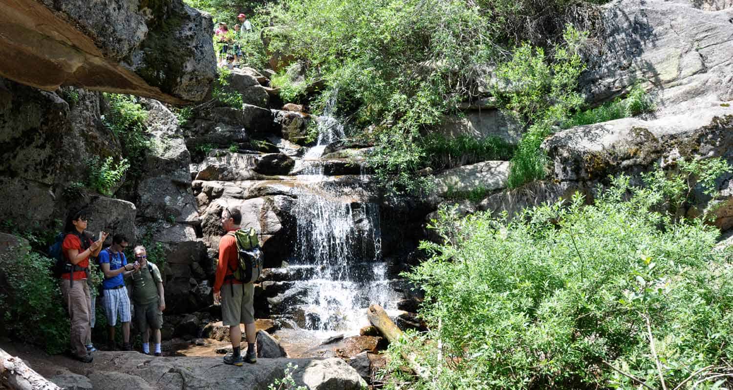
Panorama Point Trail in Corwina Park
If you are fond of panoramic views, then the Panorama Point Trail in Corwina Park is what you may be looking for. At the top of this trail you will find a beautiful view that looks out to the mountains and the plains. This medium-difficulty hike also lets you hike along a babbling brook. Check out our snapshot below for a trail map, driving directions to the trailhead and more details.
Trail Snapshot: Panorama Point Trail in Corwina Park
| Hike Distance | 2.4 miles Round Trip |
|---|---|
| Difficulty | Moderate |
| Duration | Approx 1 hr Round Trip |
| Trail Type | Out and Back |
| Starting Elevation | 6715′ |
| Elevation Gain | Approx +690′ |
| Seasons | Spring through Fall |
| Dogs | Allowed On Leash |
| Hike Trail Map | Click for a Map of Panorama Point Trail in Corwina Park |
| Denver Drive Time | 40 min |
| Driving Directions to Panorama Point Trail in Corwina Park | Click for Google Map |
| Town Nearest Hike | Evergreen, Colorado |
| Beauty | Mountain peak views, Bear Creek |
| Activities | Picnic area, fishing, hiking |
Corwina Park has two different trailheads, an east parking lot and a west lot (I don't believe they are named this way--it's just the geographic location). Hiking from the west lot (second lot you come to driving from Morrison/Denver), provides the shortest hiking route. The trail here follows a seasonal brook; its sounds and the shade from the trees make this a pleasant approach to Panorama Point.
Tips & Resources for Hiking Panorama Point Trail in Corwina Park:
- TIP: If you hike during winter, wearing a traction device like YakTrax is ideal, as well as using trekking poles.
- Trail Map for Corwina Park: Trail Map Link
- Colorado Road Conditions: Colorado Road Conditions
- After the Hike: Beau Jo’s Pizza
- Photo: We would like to express our gratitude to Ben Deutsch for sharing such an amazing photograph of this hike.
Weather
Map & Driving Directions
Click for Driving Directions
Echo Lake Trail Near Mt. Evans
Colorado's Echo Lake is looped by an easy hiking trail and serves as a trailhead to even more classic Colorado hikes. When we have friends and family visiting Colorado from out of town, this is one of best destinations for a great views. Go early to Echo Lake to get perfect photos of Mount Evans reflected in the water. Explore the full hike profile below that will give you driving directions from Denver, a trail map, and all the information you need to launch out on this adventure.
Trail Snapshot: Echo Lake Near Mt. Evans
| Hike Distance | Less than 1/4 Mile |
|---|---|
| Difficulty | Easy (but consider altitude) |
| Duration | 15 min |
| Trail Type | Out and Back |
| Elevation | 10,600′ |
| Seasons | Spring to Fall |
| Dogs | Dogs Allowed on Leash |
| Hike Trail Map | Click Here for a Trail Map |
| Denver Drive Time | 1 hr |
| Directions | Click for Google Map |
| Town Nearest Hike | Idaho Springs, Colorado |
| Beauty | Lakes, Mountain Peak Views, Wildlife: Ducks and Geese |
| Activities | Fishing, Picnic Areas, Hiking, Connections to other hikes, Visitor Center, Camping |
Echo Lake Area
A great Colorado park to take visiting family and friends. It's an hour from Denver and has very short trail, but it's a great place to introduce others to the beauty of the Rocky Mountains and to take in a high Colorado lake. The trail circles Echo Lake and connects to several other trails: Chicago Lakes, Bear Track Lakes trails, which give you access to Mount Evans Wilderness Area which is full of other great hiking trails,and Mt. Evans summit.
Near the parking area, you'll find a stone picnic shelter which was built in 1937. When the weather is getting hot, it's a great place for a picnic or a wonderful place to break out the hot chocolate on a snowy winter day.
If you are looking for more Colorado lake hikes, be sure to check out our Lake Hikes Near Denver page.
Echo Lake Colorado Camping
There are great camping opportunities at the Echo Lake Campground near the lake. Near the shores is a spruce forest. For detailed information on camping near Echo Lake in Mt. Evans, see the Recreation.gov page.
Tips & Resources for Hiking Echo Lake, Colorado :
- TIP: Early morning means that Echo lake is still, providing no windy weather, and is a perfect time to photograph or just to observe the rocky mountains reflected in the water.
- TIP: A nice short Colorado hike can be made by parking at the parking lot (see map above & below), and hiking around the lake to the Historic Echo Lake Lodge. Visit there, then turn around and enjoy the lake on the way back again.
- TIP: When you finish, drive up to the summit and enjoy the view from the top of Mt. Evans. Or visit Summit Lake Park
- TIP: One of our favorite day-trips with visitors who are not from Colorado, is to take them to Echo Lake, Mt. Evans Summit (by car), then into Evergreen for Pizza at Beaujos Pizza
- TIP: In regards to driving to the top of Mt. Evans: We avoid bringing friends who are not in good health. Be sure to have your guests drink plenty of water, and make sure they have had a day or two to get used to the altitude in the mile-high city.
- Weather: The Weather link below is for Idaho Springs. Weather at the altitude of Echo Lake may be very different, and Weather at the summit will definitely be different. Check this National Weather Service Link for more accurate forecasts.
- After the Hike: After The Hike: Beaujos in Evergreen
- Looking for something more adventurous? Try the Chicago Lakes Hike. It starts in the same parking lot.
- Trail Map for Echo Lake Park: Trail Map Link
- Colorado Road Conditions: Colorado Road Conditions
Weather
Map & Driving Directions
Click for Driving Directions

Emerald Lake Hike Rocky Mountain National Park
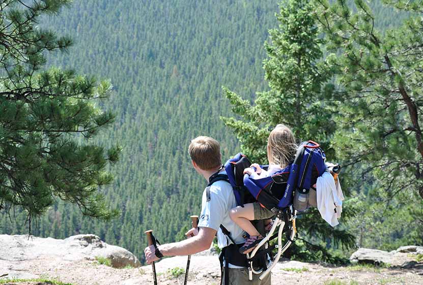
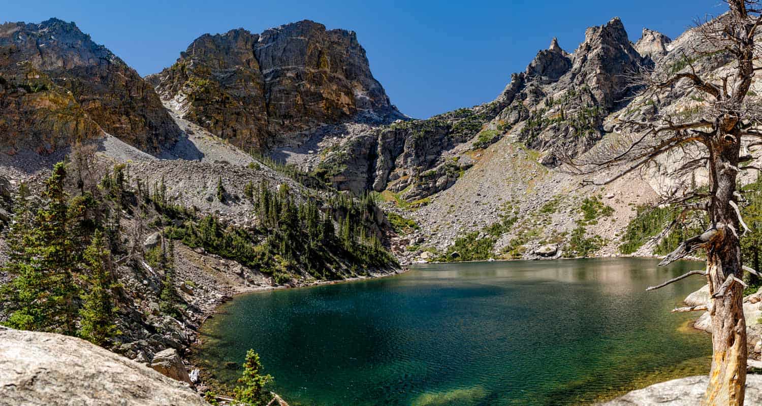
Emerald Lake is one of the most accessible hikes in Rocky Mountain National Park. If you are visiting RMNP, and have limited time to visit, the trail to Emerald Lake is an excellent option. You'll pass both Dream Lake and Nymph lake before you end your hike at Emerald Lake and it's stunning views of Hallet Peak. For more information on this hike, explore the trail profile which includes trail map, driving directions, and helpful tips and resources to enjoy this Colorado hike in Rocky Mountain National Park.
Note: Rocky Mountain National Park now requires timed entry permits from May 27th through October 10th. See the RMNP permits page for more information.
Trail Snapshot:Emerald Lake in Rocky Mountain National Park
| Hike Distance | 3.6 Miles Round Trip |
|---|---|
| Difficulty | Easy to Moderate |
| Duration | Approx 2-3hr Round Trip |
| Trail Type | Out and Back |
| Elevation Gain | Approx. +605' |
| Seasons | All Year |
| Dogs | Not Allowed in RMNP |
| Hike Trail Map | Click for a Trail Map |
| Denver Drive Time | 1 hr 45 min |
| Directions | Click for Google Map |
| Town Nearest Hike | Estes Park, Colorado |
| Beauty | Lakes, Cascade Waterfalls, Wildlife: Abert's Squirrel, Birds, Bears, Elk |
| Activities | Hiking, Snowshoeing, Fishing |
| Fee | Park Pass Required |
A Colorado Hike with a lot of bang for the buck. What we mean is that there is a lot to see on this 1.8 miles stretch of trail. Starting at Bear Lake, you'll take in a total of four Colorado lakes, and pass a small waterfall near the top of the trail. If you are looking for a handicap accessible hike, the trail around Bear Lake Loop hike may be the most beautiful, handicap accessible trail in Colorado. In the winter, the hike up to Emerald makes for a perfect snowshoe hike.
At Nymph Lake on the way up to Emerald Lake
Emerald Lake Trail Directions & Trailhead Information
The trail to Emerald Lake begins at the Bear Lake Trailhead (driving directions). In the event that parking at Bear Lake is full, you'll then need to park at the Park & Ride near the Bierstadt Trailhead and take the bus into the trailhead. This service runs 7am to 7PM and more information on the RMNP shuttle bus routes can be found at this link. The trail to Emerald Lake is located on your way to Bear Lake, off to the left, just before reaching the shore viewing area of Bear Lake.
For conditions at Emerald Lake, see the Rocky Mountain National Park Trail Conditions page.
List and Links of Destinations From Bear Lake to Emerald Lake
Tips & Resources for Hiking to Emerald Lake :
- Get to the Bear Lake trailhead early: We say this for almost every hike near Denver, but the Bear Lake Parking area is probably the busiest in the park. If you can't get there early, just take the shuttle from the lower parking area.
- The Wildlife: We have seen a beautiful black bear in this area on one occasion. It just saw us and ambled away. As with any hike where there are a lot of wildlife, keep small children within sight at all times. On your way out, be sure to stop around Moraine Park and watch the Elk.
- Snowshoeing to Emerald Lake In the winter, this is a Colorado wonderland and a very accessible trail to snowshoe. You can rent snowshoes for a great price at The Colorado Mountain Shop in Estes Park.
- PhotoS: We would like to express our gratitude to Tim Lumley and Daniel for sharing their photos of Emerald Lake in RMNP.
- Trail Map for Bear Lake Corridor: Trail Map Link
- Colorado Road Conditions: Colorado Road Conditions
- After the Hike: Kind Coffee
Weather
Map & Driving Directions
O Fallon Park Trails
hese hiking trails near Evergreen, Colorado weave through the Bear Creek area in O'Fallon Park. It's a great place to launch into the Bear Creek Canyon area. Because there are a lot of options, be sure to download the trail map and look over the five different trail options listed below in the hike profile. Scroll down for the full O'Fallon Park Trails profile and to find driving directions, pdf map, and full trail details.
| Hike Distance | 1.3 to 7 miles |
|---|---|
| Difficulty | Easy to Moderate |
| Duration | Approx 1 to 5 hrs |
| Trail Type | 3 Loop Trails and Out & Back |
| Seasons | All Year |
| Dogs | Allowed On Leash |
| Hike Trail Map | Click for a Map of O'Fallon Park Trails |
| Denver Drive Time | 35 min |
| Driving Directions to O'Fallon Park Trails | Click for Google Map |
| Town Nearest Hike | Evergreen, Colorado |
| Beauty | Mountain peak views, Bear Creek & brooks, wildflowers, & butterflies |
| Activities | Picnic areas, horseback riding, mountain biking |
O'Fallon Park is part of a series of Jefferson County and Denver Mountain Parks that are connected by Bear Creek and the Bear Creek Trail. Quartz riddles the trails and butterflies alight on flowers along the five trails that weave through the park. The O'Fallon Park picnic area is right beside Bear Creek and plenty of shade provided by the Ponderosa Pines that cover it.
Fishing at O'Fallon Park may get you some rainbow and brown trout!
Trails at O'Fallon Park
1- Meadow View Loop (2.5 miles): We actually hiked this as an out-and-back from the lot up to the vista. Great views up there, but be ready for a steady gain in elevation. It's some work, but it's worth it.
2- Panorama Point - (1.3 miles out-and-back)
3-West Ridge Loop - (3 miles)
4- Picnic Loop (1.3 miles): Stays closer to the picnic areas and makes for a nice easy walk with the family before or after lunch.
5-Bear Creek Trail - This trail runs 7 miles from Pence Park parking lot to the Lair o' the Bear Park lot. Medium in difficulty and a mountain biking mecca.
Tips & Resources for Hiking O'Fallon Park Trails :
- TIP: This is another park that can fill quickly on the weekends, but it's mainly the picnic areas. It's not necessary to go early, but it's not a bad idea.
- TIP: Keep alert for mountain bikers, especially on the Bear Creek Trail. Most of the other trails are hiker only.
- TIP: Bring a picnic breakfast or lunch.
- O'Fallon Park Trail Map: Trail Map Link
- Colorado Road Conditions: Colorado Road Conditions
- After the Hike: Beau Jo’s Pizza
Weather
Map & Driving Directions
Click for Driving Directions