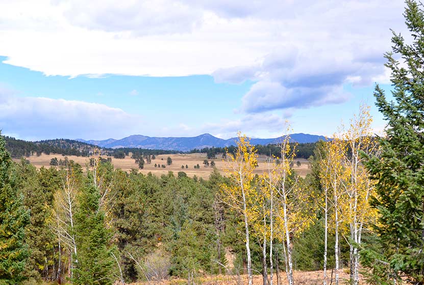
Georgetown Railroad Hike & Train Ride
After the hike, I asked our 7 year-old daughter what she thought of it. Her reply said it all, “Dad, it was awesome!” Here favorite parts were the fairy pond, a small, moss-rimmed pool probably created by miners long ago to hold drinking water, and the gleaming minerals in the rocks she picked up along the trail. I enjoyed the history and stories told by our guide, Kelsey, who had a particular love for the town and people of Georgetown and Silver Plume. This not your typical Dayhike Near Denver because it's actually a guided historic tour meets hike, plus a train ride on a vintage train back to the trailhead. Read below for all the details for this reservation-required hiking tour.
Trail Snapshot: Georgetown Railroad Hike & Train Ride
| Hike Distance | 2.3 Miles |
|---|---|
| Difficulty | Easy |
| Duration | Approx. 3 hr Guided Tour |
| Trail Type | One Way with Return on Train |
| Elevation Gain | -750′ |
| Seasons | May-September |
| Dogs | Not Allowed |
| Railroad History | Click for Georgetown Railroad Site |
| Denver Drive Time | 1 hr |
| Directions | Click for Google Map |
| Town Nearest Hike | Silver Plume, Colorado |
| Beauty | Steam Engine Trains, Old Mining Ruines, Clear Creek, History, and Geology |
| Activities | Hiking, Train Ride, and Lunch Provided |
| Fee | This is a guided tour hike and reservations are required. See the Schedule & Fares Page for the most up to date information.Lunch is included. |
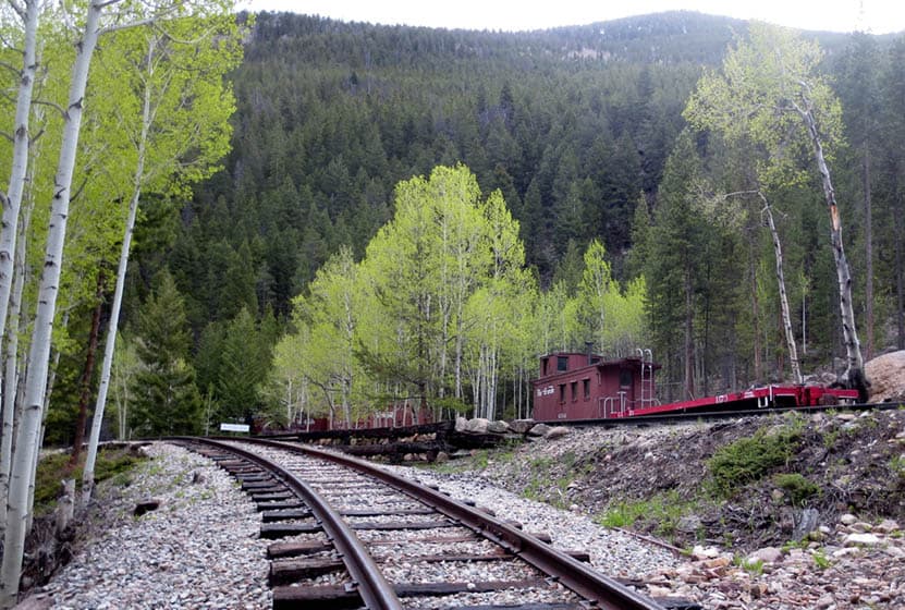
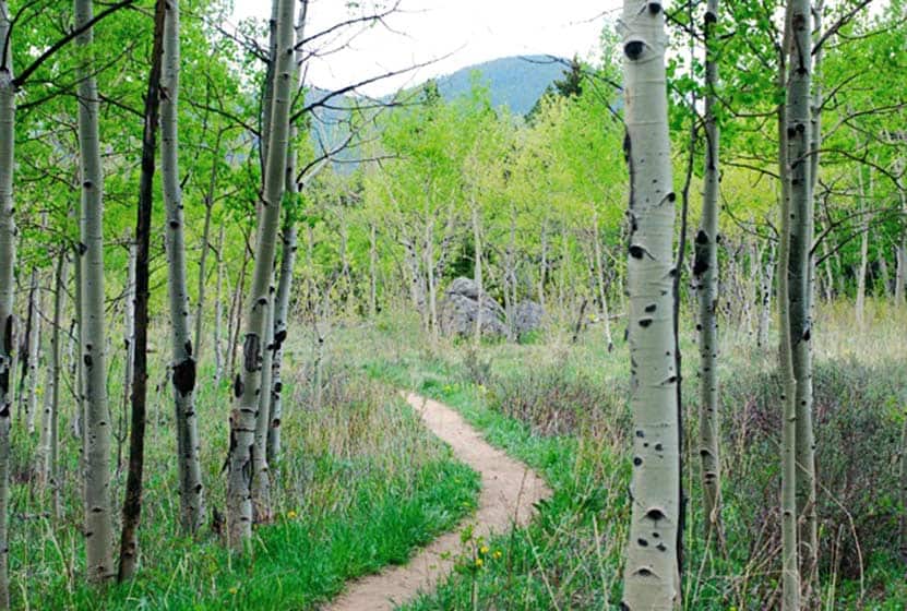
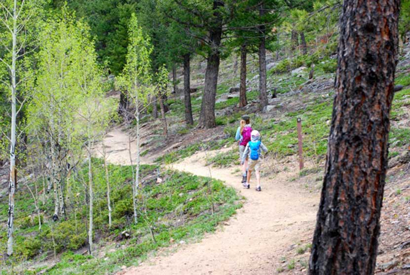
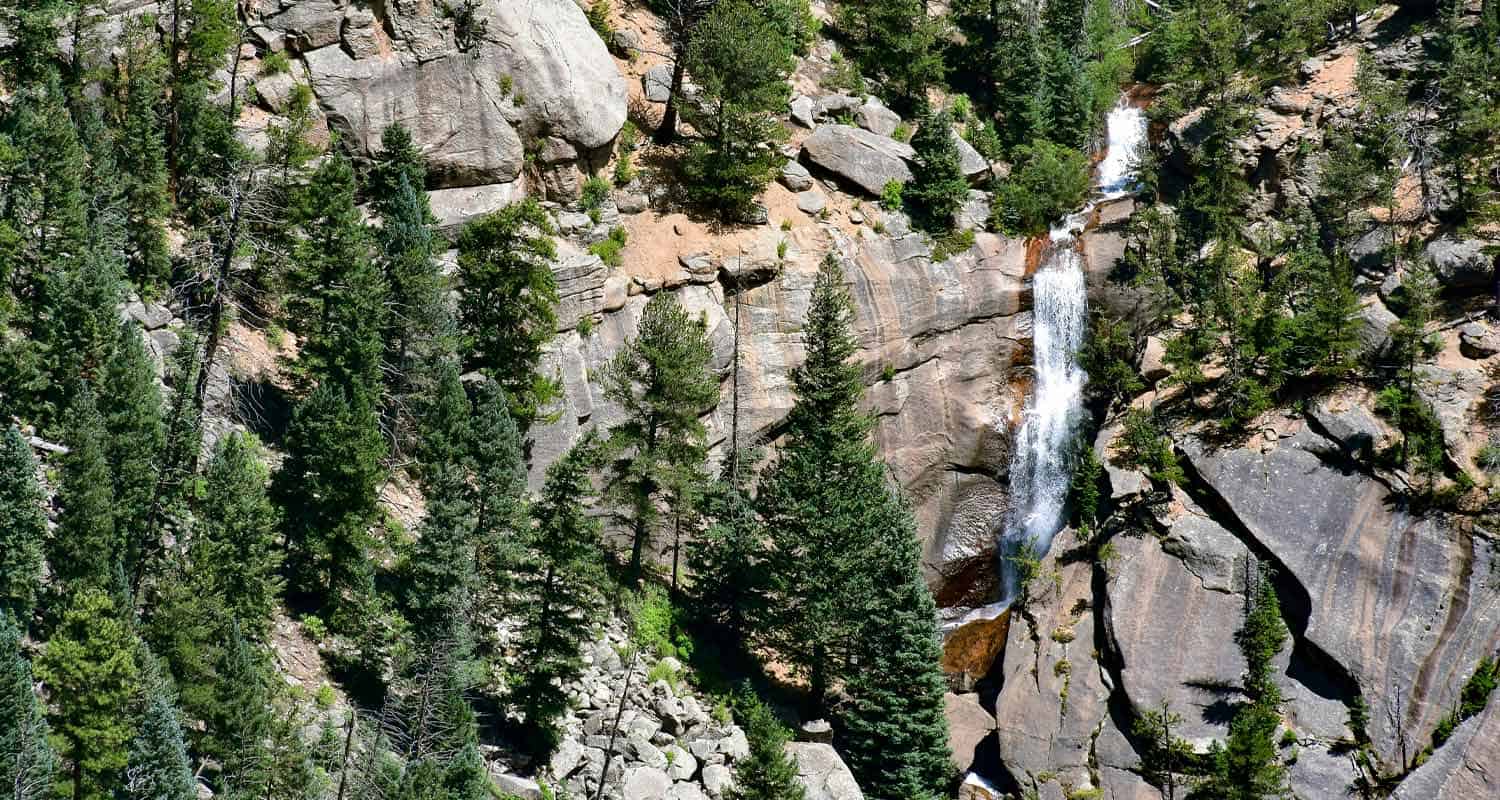
The Georgetown Railroad hike is a one-of-a-kind guided hike through the clear creek valley, a landscape decorated by the rich history of the Colorado Gold Rush of 1859. If you take just a moment to scan the mountainsides along interstate 70, you'll notice the yellow-stained tailings of abandoned gold mines. This hike takes you right through the very heart of that forgotten territory. We got to take a sneak-peek of the trail before it opened, so I brought our 7 year old daughter with me for our date-night, and she loved it.
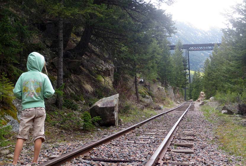
The hike begins in Silver Plume, Colorado at the historical railroad station and museum. On the hike you'll have one to two guides who accompany your party. Groups are typically about 10 hikers. The hike begins on a nondescript gravel road, but soon enters an old, overgrown cemetery. From the graveyard, the trail descends into a healthy stand of lodgepole pines. We could see mist in the valley below, and the sound of the train in the distance. Though the sounds of interstate 70 are not far away, it's like stepping back in time. The hummingbirds zooming past us, and the rapids of Clear Creek below us brought the valley alive.
The best sounds, however, came from the steam train in the valley below. Kids will love this. It's a unique experience to be on a hike, then to watch a train pass in front of you, below you, and even above you on the tracks. And it creates anticipation of the train ride back.
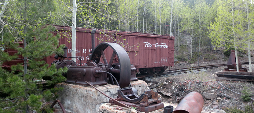
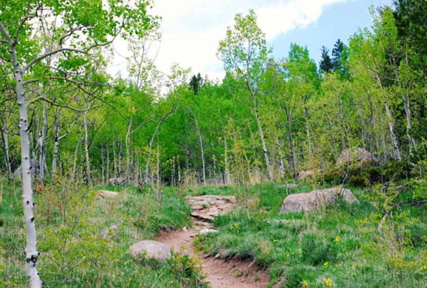
The hike itself is quite easy and could be done in about 45 minutes--if it was all about speed. But the destination for the Georgetown Railroad hike is the entire journey. Our tour guide pointed out old claim markers from the 1800's, the remains of mining equipment, barrels, and tin buckets tucked away in the woods. She told stories, and showed us things we would have missed just hiking through. At roughly halfway through the hike, you'll stop for lunch (lunch is provided) in a grove of aspens that has a great story of its own. Keep your eyes peeled for the foxes and deer that frequent this part of the valley floor.
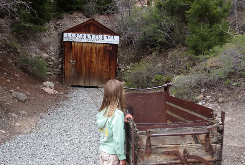
My daughter was captivated by the gleaming biotite and muscovite in the rocks alongside the trail. Our guide picked some special ones out for her to take home. After lunch, you'll hike by the Hall Tunnel, and the old Lebanon mine. Crossing the tracks, then following inactive segments, you'll make your way down into Georgetown. The trail leads under the the Devil's Gate High Bridge and ends at the Devil's Gate Station--named such because of the way the wind howls through this part of the valley.
Just when you think the fun is over, you get a 30-45 minute train ride back to your car in Silver Plume.
Tips & Resources for the Georgetown Railroad Hike & Train Ride:
- Call Ahead to book Your Hiking Tour: 1-888-456-6777
- Great for Kids: I would guess that the youngest age to take on this hike would be 6 years old, but it really depends on the child. Our daughter is pretty rough-and-tumble. The pace is right, and their are a lot of things to keep their attention.
- Supervise Kids on the Tracks: Kids will want to run fast down the railroad tracks, but the ties prove to be pretty uneven ground. Our 7 year old daughter tripped and got a little scrape on her knee, but was fine. Your guide will give you safety tips, but they will also be very engaged in giving you the tour.
- Restrooms: There are restrooms about 1/2 way through the hike at the Lebanon mine site.
- It's a Hike: I'd classify this as an easy hike, but there are some segments where the trail is steep and runs through soft gravel, where it's easy to slip. While it's a guided tour, it's not a bike path--it's still a hike.
- Footwear: Wear close-toed shoes. Boots are not necessary, but I'd recommend something that laces up.
- Colorado Road Conditions: Colorado Road Conditions
- After the Hike: The Alpine Restaurant & Bar in Georgetown
Weather
Map & Driving Directions
Click for Driving Directions

Horseshoe Trail at Golden Gate Canyon Park
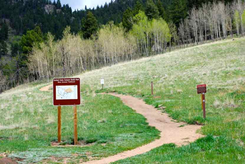
The Horseshoe Trail in Golden Gate Canyon State Park is a wonderful hike for older kids, experienced and non-experienced hikers. It's a great trail for spotting wildlife, from birds to deer, viewing fall colors and wildflowers, and taking in the beautiful scenic view along the trail. Several of the backcountry campsites areas are also accessible from the Horseshoe trail. We'll detail those locations, provide links to a trail map, driving directions and more in the trail profile on this Colorado hike.
Trail Snapshot: Horseshoe Trail at Golden Gate Canyon Park
| Hike Distance | 3.6 miles Round Trip |
|---|---|
| Difficulty | Moderate |
| Duration | Approx 2 hr |
| Trail Type | Out and Back |
| Elevation Gain | +910′ |
| Seasons | Spring through fall, depending on snow fall |
| Dogs | Allowed on Leash |
| Hike Trail Map | Click for a Map of Golden Gate Canyon Park |
| Denver Drive Time | 50 min |
| Directions | Click for Google Map |
| Town Nearest Hike | Golden, Colorado |
| Beauty | Wildflowers, spruce and fir trees, aspen meadows, big boulders, wildlife, mountain views and running stream along trail |
| Activities | Hiking only trail |
| Video | Click For a Video of Golden Gate Canyon Park |
| Pass Required | Daily Pass Link Annual State Parks Pass Link |
Golden Gate Canyon's Horseshoe Trail is a 3.6 mile out-and-back hike (1.8 miles one-way). We've rated it as moderate in difficulty because of the 900+ feet of elevation gain. The Horseshoe Trail is popular because it follows the beds of several small streams, winds through groves of aspen trees, and leads to beautiful meadows, as well as three of Golden Gate Canyon State Park's backcountry camping areas.
To get to the trailhead (first,use our driving directions). Once in the park, exit to the right out of the Visitors Center--you'll want to stop here first to pick up a map. You'll find the Frazer Meadows parking area and trailhead for the Horseshoe Trail on the left-hand side of the road. Keep in mind that parking is limited, so it would be best to arrive early. There are also restrooms at the Horseshoe trail trailhead and we found them to be kept up and clean.
One of the highlights of this trail are the streams that run along it. You'll find that there are several small bridges to cross as you make your way up the trail. Seasonal streams also mean that sections of the Horseshoe trail will get muddy on after rains and during the Spring melt-water runoff. But water also means wildflowers, and this trail comes alive with them in late Spring through the Summer.
The Horseshoe Trail also leads you to access trails for three of the five Golden Gate Canyon backcountry camping areas. Use this link to the backcountry camping brochure to get details on cost per night and how to make campsite reservations in Golden Gate Canyon State Park. The first campsite access trail is at 1.1 miles and will take you to Greenfield Meadows, which has 4 campsites. Continuing on the same spur, you can hike further in to the Frazer Meadow campsite which has 4 campsites and one backcountry shelter. If you continue on the Horseshoe trail, you'll come upon the access trail for Rim Meadow campsite at 1.3 miles. Rim Meadow also has 4 campsites.

Tips & Resources for Hiking the Horseshoe Trail:
- Park Pass: A Colorado State Park Pass is required to enter Golden Gate Canyon State Park. Check the Golden Gate Canyon Fees page for details on park passes. Some trails offer passes at self-serve dispensers.
- Printed map: The trail forks to the left, make sure to have a printed map on hand which you can pick up at the Visitors Center.
- Bug spray: for hot summer days not a bad idea.
- Sun protection: The trail is often shaded--a rare thing for Front Range hikes--but be sure to bring sun protection because it is almost 4 miles round trip and there are areas exposed to the sun.
- No cell phone: There is no cell phone coverage at Golden Gate Canyon State Park.
- Download our Dayhikes Hiking Guide for a day hike packing checklist
- After the Hike: Windy Saddle Cafe in Golden
- Road Conditions: Colorado Road Conditions
- Trail Map for Golden Gate Canyon State Park: Trail Map Link
A big thanks goes out to Lisa Palmer, a member of our Dayhikes Pathfinder Team, who hiked this trail with her family, gathered the information for the trail profile, and took the photos for this post.
Weather
Map & Driving Directions
Click for Driving Directions

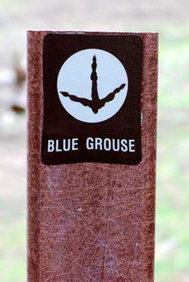
Blue Grouse Trail at Golden Gate Canyon Park
The Blue Grouse Trail is a short, 1.6-mile hike on the western edges of Golden Gate Canyon State Park. A pleasant trail with little gain in elevation and mellow terrain makes this a great escape from the city. The Blue Grouse Trail is a perfect hiking trail for spotting wildlife, from birds to deer, viewing fall colors and wildflowers, and taking in the beautiful scenic view along the trail. Explore the full hiking trail profile below for hike details, trail map, and links to similar trails near Denver.
Trail Snapshot: Blue Grouse Trail
| Hike Distance | 1.6 mile RT |
|---|---|
| Difficulty | Easy to Medium |
| Duration | Approx 1 hr |
| Trail Type | Out and Back |
| Elevation Gain | Approx. +400' |
| Seasons | All Year, depending on snow fall |
| Dogs | Allowed on Leash |
| Hike Trail Map | Click for a Map of Blue Grouse Trail |
| Denver Drive Time | Approx. 1 hr |
| Directions | Click for Google Map |
| Town Nearest Hike | Golden, Colorado |
| Beauty | Wildflowers, pine and spruce trees, aspen meadows, big boulders, wildlife, mountain views |
| Activities | Hiking, mountain biking, horseback riding (permitted on trail), Fishing at Kriley Pond (permit required) |
| Pass Required | Daily Pass Link Annual State Parks Pass Link |
| Video | Click For a Video |
Before you start this hike there are some things you should know - a Colorado State Park Pass is required to enter Golden Gate Canyon State Park. A day pass can be purchased at the Visitors Center upon entrance into the park. Some trails offer passes at self-serve dispensers, but the Blue Grouse Trail does not.
To get to the Blue Grouse trailhead, pass Kriley Pond and take the first right at Mountain Base Road. The trailhead parking area is to the right at the fork in the road. At the trailhead you’ll find picnic tables. There is a porta-let at Kriley Pond and there are restroom facilities at the Visitors Center. Below you'll find more details on the trail, Kriley pond, and some information on camping at Golden Gate Canyon State Park.
Hiking the Blue Grouse Trail
You'll make your way along a nice dirt path with a few rocky sections. The elevation gain is slight, and this short hike can be turned into a longer one by joining up with the Mule Deer Trail where the Blue Grouse trail terminates at .7 mile. Mule Deer Trail is a 7.4 mile loop, and there is a Golden Gate Park map at the trail intersection.
The Blue Grouse Trail is a popular trail for mountain bikers who use it to access the longer trails in Golden Gate. Mountain bikers in Colorado are typically very considerate of hikers, but just be aware that you'll be sharing the trail with others. After the initial rise, the trail is more gentle as it ascends the hillside. You'll be drawn to the rock outcroppings ahead and a beautiful grove of aspens.
Tips & Resources for Hiking the Blue Grouse Trail:
- Trail options: View the Golden Gate Canyon Park map to see the various other trail options you have after hiking the .7 mile in on Blue Grouse.
- Rim Meadows: a great destination if you would like to continue on the Mule Deer Trail but are not wanting to hike the entire Mule Deer trail loop.
- Picnic: Because Golden Gate Canyon State Park is an hour drive, make a half-day or full-day out of your trip. Bring a picnic, and sling up a hammock for a nap in the shade.
- Download our Dayhikes Hiking Guide for a day hike packing checklist
- Sun protection: The trail is only partly shaded, so be sure to bring sun protection for the parts not covered.
- After the Hike: Buffalo Moon Coffee
- Road Conditions: Colorado Road Conditions
- Trail Map for Blue Grouse Trail: Trail Map Link
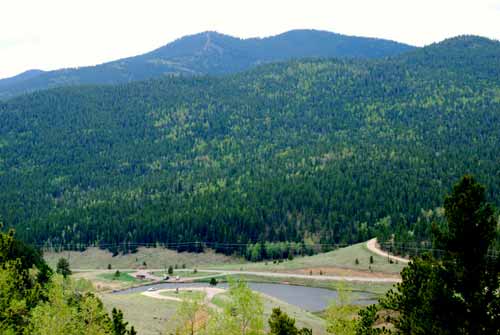
Kriley Pond at Golden Gate Canyon State Park
Kriley Pond is a popular fishing spot in Golden Gate Canyon State Park. In the fall, the hillsides are peppered with the golden glow of Aspens.The early morning hours are the best time to visit if you want to soak in the songs of Colorado songbirds before families and fisherman arrive. Fishing in Kriley Pond requires a Colorado Fishing License. There are several other ponds to visit at Golden Gate Canyon, including: Ranch Ponds, Slough Ponds, Dude's Fishing Hole, and the pond at Forgotten Valley.
Camping in Golden Gate Canyon State Park
There are several camping options at Golden Gate. However, because this State Park is less than an hour from Denver, the sites can fill up fast in the busy summer months. There is a car camping area at Reverends Ridge, a tents only site at Aspen Meadows, 20 backcountry shelters, and a limited number of cabins and yurts that can be reserved. All sites require fees which are posted at the Golden Gate Canyon Camping page.
We want to thank Lisa Palmer, a member of our Dayhikes Pathfinder Team, who hiked this trail with her family, gathered the information for the trail profile, and took the photos for this post.
=
Weather
Map & Driving Directions
Click for Driving Directions

First and Second Flatirons Hike in Boulder
Hiking the Flatirons near Boulder, Colorado is a must. The trail draws you across an green meadow, then up through a notch between the First and Second Flatiron. You'll find the best part of this hike in the Flatirons at the end of the trail: some breathtaking and unmatched views of Colorado's Rocky Mountains. There's even more though. Explore the trail profile below to get links to the Flatirons map, hiking tips, trail details, and driving directions to the Chautauqua Park trailhead.
First and Second Flatiron Hike Trail Snapshot
| Hike Distance | 2.6 miles Round Trip |
|---|---|
| Difficulty | Moderate |
| Duration | Approx 2 hrs |
| Trail Type | Out and Back |
| Elevation Gain | +1400′ |
| Seasons | All Year |
| Dogs | Allowed on Leash |
| Hike Trail Map | Click for Map for Boulder Colorado's Flatirons Hike |
| Denver Drive Time | 45 min |
| Directions | Click for Google Map |
| Town Nearest Hike | Boulder, Colorado |
| Beauty | Views of Continental Divide, Expansive Meadows, Wildflowers, Flatirons Rock Formations, Cliffs |
| Activities | Hiking, Rock Climbing, Picnic Areas |
| Video | Click For Video |
The Flatirons are the most prominent feature of Boulder Colorado's landscape. They are beautiful to take in from a distance, but they are even better to explore. Here I'll give you a some options on how to make the most of the First and Second Flatiron trail, and some details on what to expect.
The Flatirons Trailheads at Chautauqua
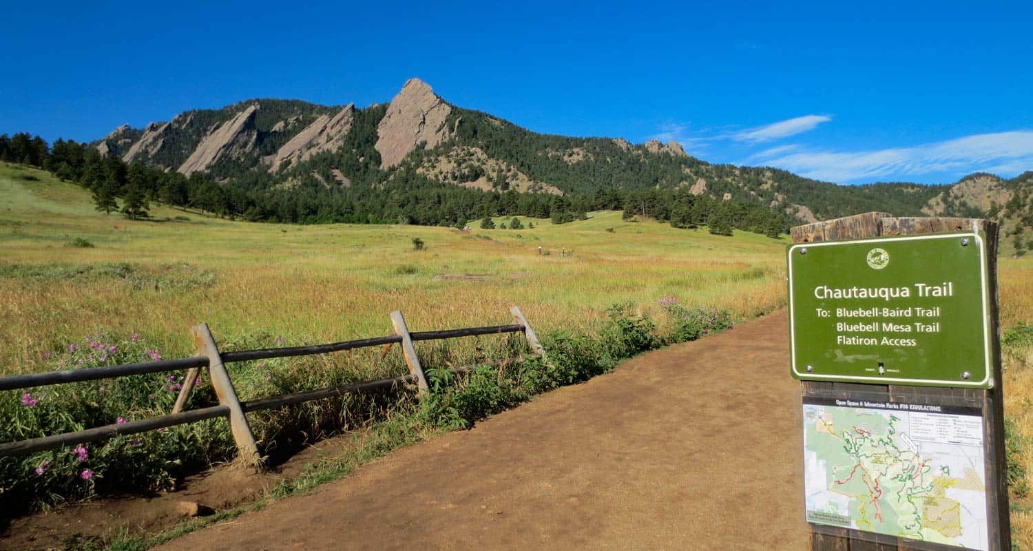
#1 - Chautauqua Trailhead: You can start your hike from a couple different places. I chose Boulder's Chautauqua Park trailhead. The parking lot will fill up fast, by 8:30 on the weekend, but you can park along Baseline Road. The city of Boulder is doing some improvements on the parking area beginning September 3rd, 2013 and it looks like the lot will be closed. Here's a link for construction updates. But don't let that deter you, just park out on Baseline. The Chautauqua trailhead features an historic Ranger Cottage (link for hours of operation), and you'll find free trail maps for the flatirons in a box attached to the sign at the entrance to meadow.
#2 - Enchanted Mesa Trailhead: This is a lesser known trailhead (but probably well known by locals). Here's a google map to help you find it. From here, you can walk across to Chautauqua Park and pick up the Chatauqua Trail, or you can make a longer trip out of it by following the McClintock Upper Trail in. See the Chautauqua Area Hiking Map for details.
Get our Dayhikes Near Denver Hiking Guide. It includes our favorite hikes near Denver, packing lists, hiking food and snack ideas, and tips for hiking the Front Range of Colorado.
The Flatirons Panorama:
In the panorama video above, you'll see that the first flatiron is the most prominent. It's on the far right (North) and the second and third flatirons follow it to the south. There is an impressive canyon between the second and third flatirons that you'll get to peer down into towards the end of the trail. But let's start this hike profile at the trailhead.
The First Flatirons Trail Sequence
Here's the basic set of trails I'd recommend just because it's the most direct approach: Chautauqua Trail to First and Second Flatiron Trail. On the way back, I'd recommend the Bluebird Mesa trail; it takes you through a pine glade along the spine of a Bluebird Mesa, then gently drops back down to the Chautauqua trail near the trailhead. This makes for a roughly 2.5 mile hike.
Make it a loop. Deb Stanley details an interesting loop by taking a little known trail down the back side of the flatirons that hooks back into the Saddle Rock Trail. Looks like fun, but it also looks like it could be easy to get turned around in there if you're not careful. Check out the details on her loop trail profile if you're interested in taking this route.
First and Second Flatirons Hike Details
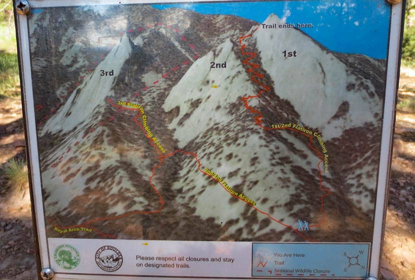
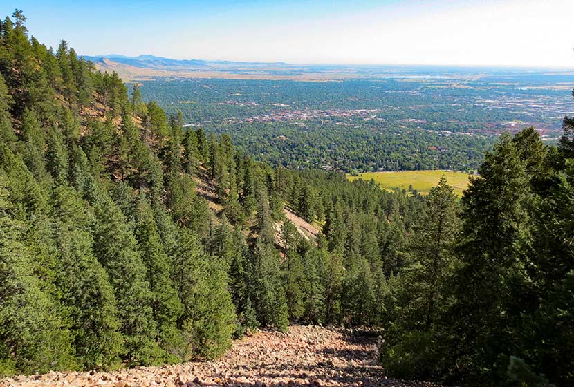
This photo gives you the best overview of the Flatirons one and two trail. Basically, once you break out of the meadow and start on the 1st and 2nd Flatirons trail, your going to ride the ridge of the 2nd flatiron up to a notch between the 1st and 2nd Flatirons. The trail continues behind the flatirons, then bends north and takes you up into a canopy formed by the back of the first flatiron.
 Starting at the Chautauqua Trail, you'll hike through the spectacular meadows at the base of the flatirons. If it's after a rain, be prepared for a lot of rain along what is essentially a fire road. The sides of the trail here have a good bit of poison ivy that tries to reach out and touch your calves, so keep an eye out for it. What I found most interesting about this section of the trail was the diversity of both plants and trees along the trail. There is a greater variety of deciduous trees and shrubs that I've seen anywhere on the front range.
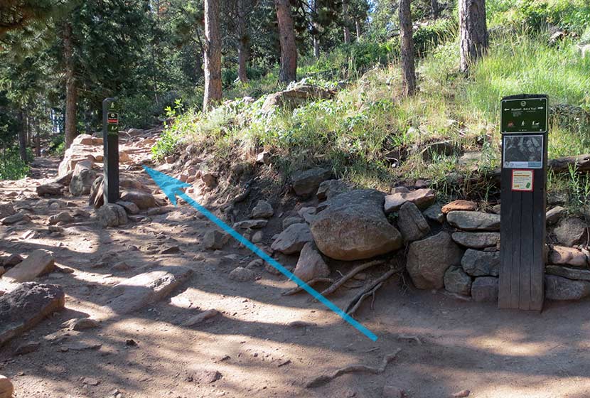
After taking the Bluebird-Baird Trail (left), you'll encounter a fork in the trail. Follow the signage towards the 1st and 2nd Flatirons trail (see photo below). Soon the trail will fork again and you'll want to take the 1st and 2nd Flatirons trail. The signage is really good in the Chautauqua/Flatirons area.
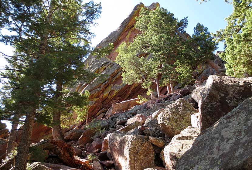
Emerging from the woods, you'll hike up through a long talus field, but the trail is well-constructed through this gigantic pile of rock. Be sure to look back at the views that open to Boulder.
 The trail goes in and out of the shade, over a lot of rock, and eventually to a short scramble over some larger rock to regain the trail. The next landmark you'll reach is the notch between the first and second flatiron; you'll see the angled outcrop of the second flatiron just below the notch (photo below). This is a great place to stop and relax.
 The notch between the first and second flatiron offers more views of Boulder and a birds-eye view of the CU campus, it's terracotta roofs against the green of the city lawns.
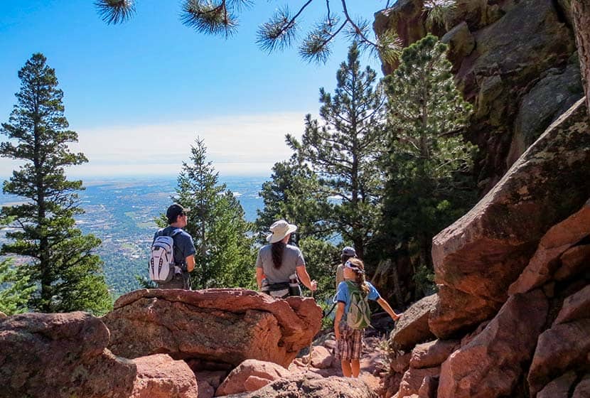
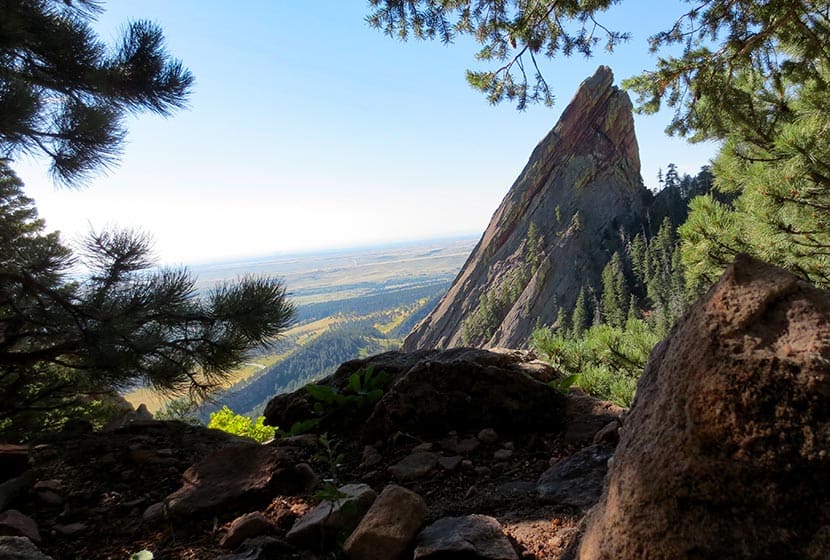
But the better place to take a break is just behind the notch. Here, you'll be able to look down into canyon that runs between flatiron two and three, and you get a great view of the imposing profile of flatiron three.
 Then take the trail up a few switchbacks as it bends north. You'll hit a saddle but the trail will continue to bend to the right, until you find yourself in the shade of the massive top of the first flatiron. Back here you'll find all kinds of rock shelves and nooks to sit and take in some of fantastic views of Colorado's Rocky Mountains to the West.
 Tips & Resources for Hiking the First and Second Flatirons:
- TIP: This hike gets really crowded, so start early (before 8:30 AM).
- TIP: Take a lunch or breakfast and coffee with you. The first flatiron nooks are perfect for just sitting and enjoying a picnic.
- TIP: Weather can come up fast on the flatirons in the summer. Just be aware that it can change fast and bring a rain jacket.
- TIP: Dogs are allowed if they are leashed. Boulder does have a special tag you can get for your dog to allow it off leash in the park. It's called the Voice and Sight Control tag and you can get more information here.
- After the Hike: Ozo Coffee Roasters in Boulder
- Trail Map for Chautauqua Park: Trail Map Link
- Colorado Road Conditions: Colorado Road Conditions
Weather
Driving Directions to First Flatiron Trailhead
Click for Driving Directions
Mt. Bierstadt Trail on Guanella Pass
Summit a Fourteener, Mount Bierstadt, or go for an easy hike with your family high in Colorado's Rocky Mountains. In short, you've got options on this trail near the top of Guanella Pass. You can choose an easy stroll or a difficult hike. Explore the trail snapshot and profile below for hiking, camping, and trail map info.
Trail Snapshot: Mr. Bierstadt Hike at Guanella Pass
| Hike Distance | 1 to 7 miles Round Trip |
|---|---|
| Difficulty | Easy to Difficult |
| Duration | 1 to 6 hours |
| Trail Type | Out and Back |
| Elevation Gain | Up to 2400' |
| Seasons | Best Late Spring to Fall |
| Dogs | Allowed on Leash (avoid b/c of fragile ecosystem) |
| Hike Trail Map | Click for a Trail Map |
| Denver Drive Time | 1 hr 30 min |
| Directions | Click for Google Map |
| Town Nearest Hike | Georgetown, Colorado |
| Beauty | 14ers, high country tundra, peak top views, lakes |
| Activities | Hiking, camping, summit Mt. Bierstadt, picnic |
You've got options with the Mount Bierstadt trail. First, we'll profile the hike to the summit. Below that, you'll find some information on how to just explore the area with your family or friends, making this an easy hike high in the Colorado mountain.
Climb Your First Colorado Fourteener
Mt. Bierstadt is popular, not just because it's so close to Denver, but it's also one of the easier and more accessible of Colorado's 54 fourteen thousand foot peaks. The Mount Bierstadt trail can be accessed on the south side of Guanella Pass from the Mt Bierstadt trailhead (click here for map and directions from Denver). It's important to be aware that the weather can change in an instant in the mountains, and that snow can come in fast even in the late Spring and early Fall. As with any Day Hike, be sure to (at least) pack the 10 Essentials.
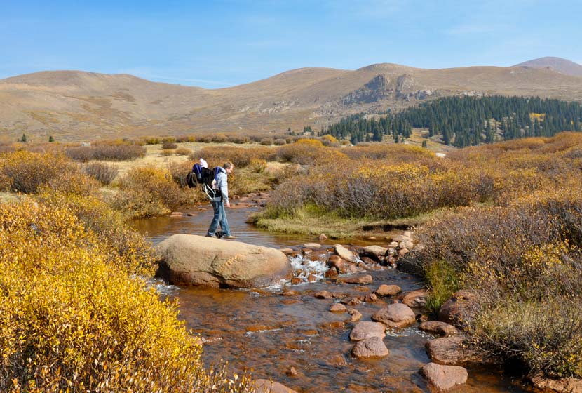
The Bierstadt trail is well marked; you'll follow signs down to a boardwalk, then to Scott Gomer Creek. After crossing the creek, the trail will become more steep, and the steepness will increase as you make your way to the summit. The trail winds gently through the tundra until you are about three miles in when the green and brown gives way to rock. Follow the west ridge up to the summit of Mount Bierstadt. For a detailed trace and profile of the Mt.Bierstadt route, see this Route #1 Bierstadt profile on 14ers.com.
Make it an Easy Family Hike
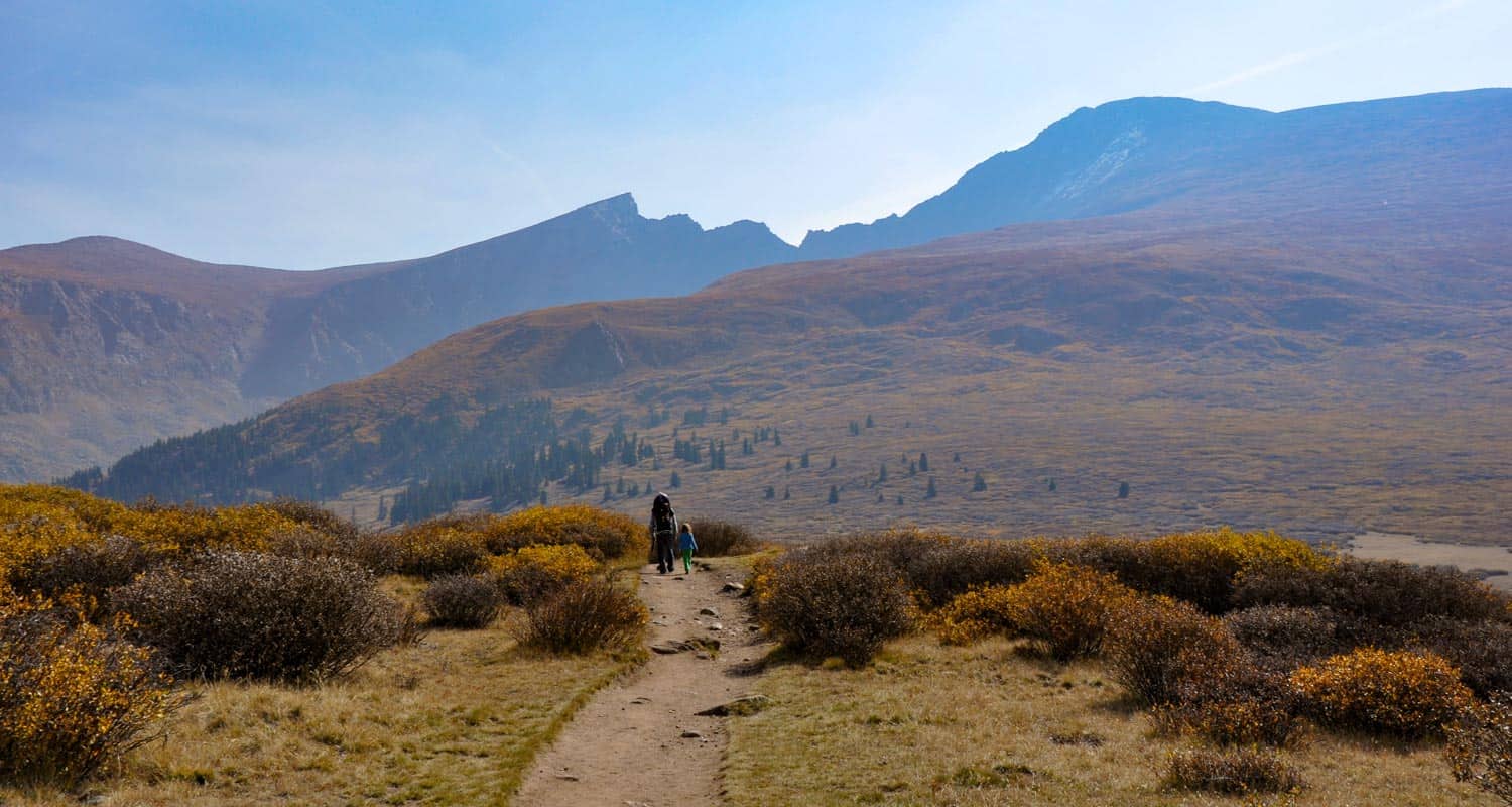
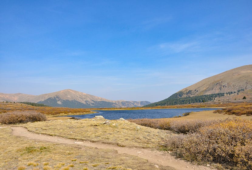
Hiking Colorado's Bierstadt trail doesn't mean that you have to summit. In fact, the first mile of trail is really tame. It takes you over a creek, through willows, and by two small high mountain lakes. If you want to gain additional views, you can add another half mile of moderate hiking that will take you above the valley floor.
We took our 4 1/2 year old, 2 year old with us in the Fall and they loved it. Dog's on the Mount Bierstadt trail must be kept on a leash and need to be kept 100' from water sources (in short, they aren't allowed to play in the lakes and streams). In fact, because we'd recommend that you leave Fido at home because of the fragile alpine tundra ecosystem. In August of 2012, Missy, a German Shepherd, was rescued after being stranded on the peak for eight days. You can read more about her ordeal and the rescue in this Denver Post article.
Camping Near the Mt. Bierstadt Trail
There are a lot of campground sites along both sides of Guanella pass that are managed by the forest service (fee required) and dispersed camping is allowed on US Forest and wilderness areas. Below you'll find a few important links to camping information for the Mt. Bierstadt and Guanella Pass Area.
- Mt. Evans Wilderness Hiking and Camping Regulations.
- Camping Information and Regulations for the US Forest Service
- Guanella Pass Campground
- Burning Bear Campground Near Mt. Bierstadt Trail: Jennifer Mason does a nice job profiling both the Burning Bear and Whiteside campgrounds on her site.(note: Whiteside has been permanently closed)
- For More Campgrounds along Guanella Pass, use the Recreation.gov site and do a search for Guanella Pass Road
Tips & Resources for Hiking the Mt. Bierstadt Trail:
- TIP: Go Early; the parking lot at the Mt. Bierstadt Trailhead fills fast.
- TIP: If you've never summited a 14er before, be sure to read this great article by Lindsey Koehler of 5280 Magazine.
- TIP: If you plan to summit Mount Bierstadt, start early so that you can be back at the trailhead before the almost daily summer thunderstorms role in. I'd recommend starting around 6am, so that you're back at your car around 11am.
- TIP: Hiking times vary. Those who frequently make the assault on Mt. Bierstadt (even trail run it), can make it up and back in 3 hours. The average is 5hrs, but adjust for experience and how good of shape you're in
- After the Hike: Tommy Knocker Brewery
- TIP: The weather will be cooler at the trailhead than the posted Georgetown, Colorado temperature below. It will be even cooler at the summit of Mt. Beirstadt.
- Trail Map for Guanella Pass: Trail Map Link
- Colorado Road Conditions: Colorado Road Conditions
Weather
Map & Driving Directions to Trailhead for Mt. Bierstadt
Click for Driving Directions
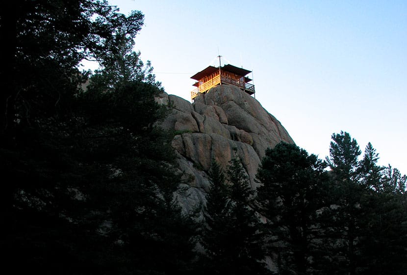
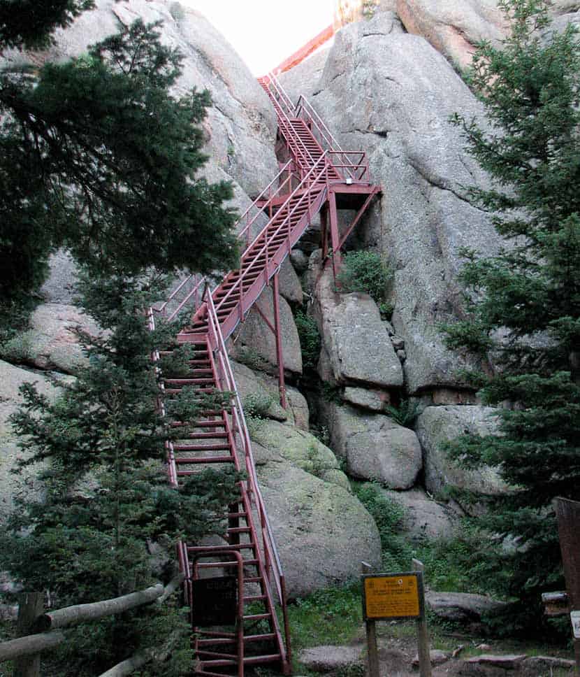
Devils Head Fire Lookout Hike
If you've not hiked to the top of the Devils head trail and climbed the 143 steps to the fire lookout, then I think you're not allowed to have one of those Colorado Native bumper stickers. The Devils Head trail is the classic Colorado Front Range hike and is just about an hour from the center of Denver. The views from the top offer a 360-degree panorama of mountains layered upon mountains. Scroll down to explore the trail profile and photos of one of the best hikes on the Colorado Front Range.
The Devil's Head Area is now open again. for the most current information, see the USFS Devils Head Page.
Devil's Head Lookout Trail Snapshot
| Hike Distance | 2.8 Miles Round Trip |
|---|---|
| Difficulty | Moderate |
| Duration | 2hr + |
| Trail Type | Out and Back |
| Elevation Gain | +940′ |
| Seasons | Mid-May to Mid-September |
| Dogs | Allowed on Leash |
| Hike Trail Map | Click Here For NG Map Store |
| Denver Drive Time | 1 hr 15 min |
| Directions | Click for Google Map |
| Town Nearest Hike | Sedalia, Colorado |
| Beauty | Front Range Views, Rock Formations, 360 views, sunrise |
| Activities | Fire Tower Lookout, Picnic Area, Camping Nearby, Hiking Trails |
| Video | Click For Video |
Parking & Trailhead for Devils Head Hike
Devils Head Hike Map
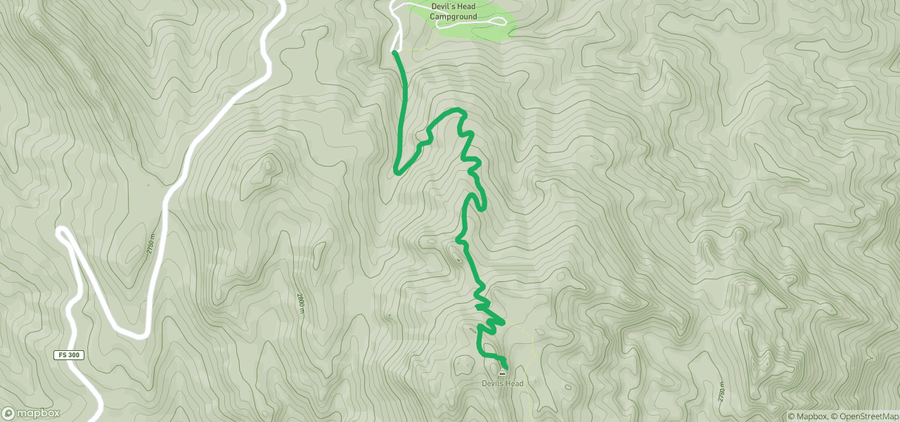
The Hike: Devils Head
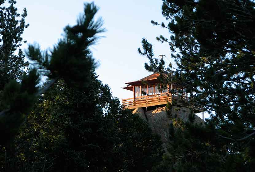
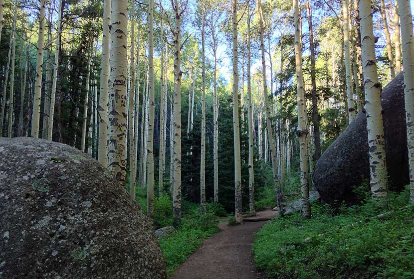
This Colorado hike begins in a glade of tall aspens, some of the biggest we've seen this close to Denver. Then the trail meanders through some unusual rock formations until the trail opens into a high meadow where a quaint ranger cabin sits nestled in the trees. Up ahead and to your left, you'll see the red steps that lead to the Devil's Head fire lookout.
The Devil's Head fire lookout is the only operational fire lookout in the state of Colorado and is over 100 years old, though the current structure was built in 1951. If you are a history buff and enjoy historical photos, check out these this site: Firelookout.org
Bill Ellis and his wife have been operating the lookout for over 25 years, and many visitors remark that their discussions with Bill are the highlight of their trip. The Denver Post did a great piece on the Ellises and the fire lookout that is worth reading -
link to the Devils Head Article by the Denver Post.
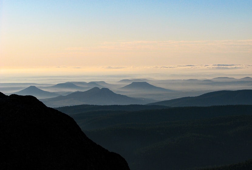
The views from Devil's head reveal features of Colorado's Front Range that are rarely discovered. My favorite is looking North down the spine of the foothills where red tinted rock formations push up from the peaks and resemble a chain of castles high above the forest.
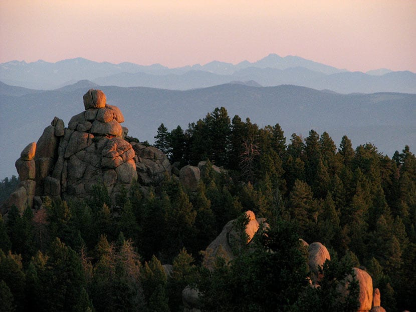
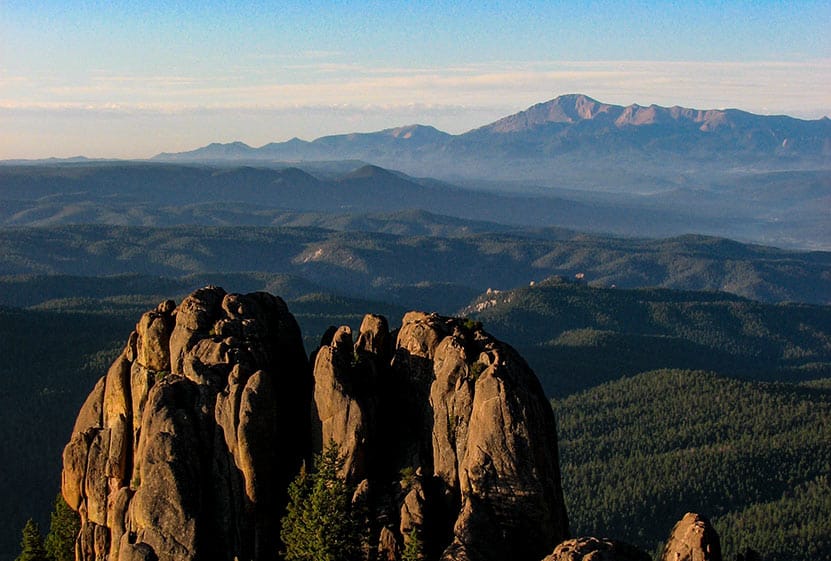
Pikes Peak dominates the landscape to the South. And the Western view from Devil's Head is riddled with the red mountains of the Tarryalls, Kenoshas, and Platte range. And there are few signs of civilization, at least not in the early morning hours when I took these photos.
Tips & Resources for Hiking Devils Head
- TIP: Go Early: Devil's Head is one of the most popular hikes on the front range. If you are hiking this on the weekend, try to get to the trailhead by 8am if you want a less crowded experience hiking Devils Head.
- TIP: Go Even Earlier for photography: The rising sun lights up the front range, and you can see hundreds of miles of mountains from the tower on Devil's Head.
- Camping: There is a USFS campground near the trailhead parking area. Some friends of ours have camped here and said it was a good experience. See the USFS Devils Head Campground site for details on camping and parking fees.
- TIP: Rough Drive: The 10 miles of Rampart Range Road can be dusty and a real washboard experience. 2WD is sufficient and this road is kept in pretty good condition, but be prepared for a less than comfortable drive on your way to Devils Head.
- TIP: Rampart Range Road is closed December 1st to about April 1st each year. You can call the South Platte Ranger District at 303.275.5610 to get the current status of the road.
- TIP: Be Lightning Aware: The front range is notorious for its lightning strikes and this is the highest point. If weather is looking bad, play it safe.
- Colorado Road Conditions: Colorado Road Conditions
- After the Hike: After the Hike: Obrien's Cafe in Sedalia
- Trail Map for Front Range USFS: Trail Map Link
Weather
Map & Driving Directions
Click for Driving Directions

Looking for more waterfalls near Denver? Explore our more than 50 Colorado Waterfall Hikes, our favorite Waterfall Hikes in Rocky Mountain National Park, or 7 Waterfalls within One Hour of Denver.
Elk Falls - New Waterfall Near Denver
Elk Falls in Colorado's new Staunton State Park opened to the public in 2013. This highest waterfall near Denver had been unknown to most, and inaccessible, except to a few. Now it's an adventure waiting for able hikers! If you are a fan of waterfall hikes and you live near Denver, you'll know that it's kind of slim pickings; most of the best waterfalls in Colorado require driving beyond the Front Range, or into Rocky Mountain National Park. Elk Falls, is just 50 minutes from Denver! The 3700 acre Staunton State Park offers incredible hiking, rock climbing, and beautiful rock formations - all making for some great Colorado day hikes. Explore the full Elk Falls hike profile below for trail map, driving directions, and many of the details you need to enjoy this adventure in Staunton State Park.
Trail Snapshot: Elk Falls Overlook Hike at Staunton State Park
| Hike Distance | 10.8 miles Round Trip |
|---|---|
| Difficulty | Moderate to Difficult |
| Duration | Approx 4-6 hr |
| Trail Type | Out and Back |
| Starting Elevation | 8200′ |
| Elevation Gain | +900′ |
| Seasons | All Year |
| Dogs | Allowed On Leash |
| Hike Trail Map | Click for a Map of Staunton State Park |
| Denver Drive Time | 45 min |
| Driving Directions to Staunton State Park | Click for Google Map |
| Town Nearest Hike | Conifer, Colorado |
| Beauty | Waterfall, Rock Formations, Meadows, Pine Forest, Ponds, Hummingbirds, and Deer |
| Activities | Hiking, Photography, Mountain Biking (on many trails) |
| Fee | Entrance Fee or State Parks Pass Required |
Parking & Trailhead Information for Elk Falls in Staunton State Park
The parking and trailhead area are immediately noticeable after the park entrance. On weekends, things can really back up at the entrance due to the number of visitors and those who need to purchase a parks pass. If you don't have your yearly parks pass, you can pick one up at a local Kings Soopers grocery store at the customer service area. Because your hike will begin with the Staunton Ranch Trail, the main artery of Staunton State Park, just look for the main trail which heads to the center of the park. If you've parked at the lower parking area, you'll have two Trailheads before you, the Staunton Ranch and the Mason Creek trailheads. Be sure to choose the Staunton Ranch Trail. The Elk Falls overlook can be reached by starting on the Mason Creek Trail, but its a significantly longer and more difficult 17 mile loop hike. Maps are available at the entrance and highly recommended for this hike.
The Hike: Elk Falls in Staunton State Park
The Staunton Ranch Trail leads hikers into the heart of Staunton State Park, through stands of ponderosa pine and past the Staunton Rocks climbing area. After 3.3 miles, the trail ends at a trail intersection with three new trails. The most direct route to the Elk Falls overlook is to choose the Bugling Elk trail which follows a small creek for 1.1 miles until it arrives at Elk Falls Pond, a good place to stop and Fish.
At Elk Falls Pond, a third trail, the Lion's Back Trail, leads another 1 mile up to the Elk Falls Overlook. Atop a highpoint, hikers will gain great views down to where Elk Falls drops from the cliff face into a beautiful mult-tiered waterfall. Out and Back, its a total of 10.8 miles.
Colorado State Parks is working on an Elk Falls Trail project that will eventually open access to the base of Elk Falls. This is projected to be completed and opened to the public in the Fall of 2016.
If you'd like to add a more challenging return segment to your hike and see new areas of the park, hikers can pick up the Marmot Passage trail until it meets with the hiker-only Scout Line trail, which eventually leads back to the main Staunton Ranch trail. This return route will add additional mileage, difficulty, and time to the hike back. Consult the trail map and topo lines to get a feel for the demanding nature of this option.
Tips & Resources for Hiking To Elk Falls Overlook:
- TIP: Getting into the park can be slow at times, so be prepared to wait at the entrance on busy weekends.
- Trekking Poles & Traction Devices are Recommended in Spring and Winter: During this time of year, there can be patches and even longer segments of snow and ice on the trail. Because of this, we recommend Trekking Poles and/or Traction Devices for this trail.
- Trail Map for Staunton State Park: Trail Map Link
- Packing List: Always pack the 10 Essentials. Download our Hiking Guide to get list and dayhiking packing checklist.
- Colorado Road Conditions: Colorado Road Conditions
- After the Hike: Crow Hill Cafe in Bailey
- We would like to express our gratitude to Bill Chopp for sharing such an amazing photograph of Elk Falls.
Weather
Map & Driving Directions
Click for Driving Directions
Looking for more waterfalls near Denver? Explore our more than 50 Colorado Waterfall Hikes, our favorite Waterfall Hikes in Rocky Mountain National Park, or 7 Waterfalls within One Hour of Denver.
Forsythe Canyon to Waterfall and Gross Reservoir
Looking for a trail that will provide some shade on a hot Colorado day? This hiking trail has shade, plus a waterfall, a stream, a canyon, and lake. It's hard to beat. Forsythe Canyon is just outside Boulder, Colorado (1hr 15min from Denver), and is an easy to moderate hike. Check out our full hiking trail profile for details and be sure to read the directions to this trailhead carefully.
Trail Snapshot: Forsythe Canyon Trail
| Hike Distance | 2 miles+ Round Trip |
|---|---|
| Difficulty | Easy |
| Duration | 2 hr+ |
| Trail Type | Out and Back |
| Seasons | Late Spring to Fall |
| Dogs | Allowed on Leash |
| Denver Drive Time | 1 hr 15 min |
| Directions | Click for Google Map (note: people miss trailhead often, see profile and comments below for details) |
| Town Nearest Hike | Boulder, Colorado |
| Beauty | Waterfall, Wildflowers, Reservoir, Woodland Canyon |
| Activities | Hiking Trails |
The shade of a wooded canyon, combined with a waterfall, ending at a blue lake, make this hike near Boulder Colorado worthwhile. Though it's probably 25' high, the waterfall is not what I'd call spectacular. So, if you are going for this waterfall, I'd recommend going early in the season when the snowmelt is at its peak in May and early June.

The trail winds gently downhill through a canyon, beside a creek, sheltered beneath fir and spruce. In fact, of the hikes we have profiled, this trail may provide more shade than any trail near Denver. You'll come upon the falls about 1 mile into the hike and the reservoir is just 200 yards further down the trail. In fact, reaching the clear blue water was the highlight for our kids.
We skipped rocks and hiked along the sandy and rock rim so that we could explore more of the lake. With the water levels being so low, and a large tree blocking the shot, I couldn't get a good photo of the falls.

One important note. The trail is a bit difficult to find just above the waterfall, in fact, if you take the wrong route, it appears to lead you down a rock face - which is not a good idea, especially with kids. The correct route bears to the left of a cedar tree, will lead you up further above and away from the falls, then back down into the canyon floor. I've posted a photo below showing the juncture. Even in the photo, it's hard to see the trail.

Tips & Resources for Hiking Forsythe Canyon:
- TIP: If you are coming from Denver, it's quite a drive. The payoff is that the parking lot was almost empty on memorial day weekend. We recommend making a day of it and spending some time in Boulder before or after the hike.
- TIP: The Reservoir is stocked with Kokanee Salmon, and this stretch of it is where they supposedly like to hang out. So, bring your fishing gear. Here is a link to a Dept. of Wildlife PDF with information on the stock on the lake and some links to the fishing regulations for Gross Reservoir.
- TIP: Swimming and Wading are Prohibited
- TIP: The Google Map & Directions: The trailhead parking lot is new, and really nice (with a restroom), and the directions above are accurate. However, I get a lot of email from folks who plug this map into their GPS and somehow miss it and try to drive down FR359. Remember, GPS is only accurate up to a point. Once you turn off of Magnolia and onto 68, drive for 2 miles then turn right into the parking lot just before FR359. Look for a gravel parking lot with a restroom and a wooden fence surrounding the perimeter. You can zoom in on the Google Map to get a feel for what it looks like. Google updated the satellite photos recently, so the parking lot now shows. You can check here for seasonal road closures of FR359. Or you can all 303-541-2500 (Boulder Ranger District) to check the road status before heading out on your adventure
- TIP: Be sure to take the recommended route using Magnolia road. We've had a few emails from folks trying to reach the Forsythe Canyon Trailhead from Lakeshore Road. My understanding is that it's not possible, or at least highly problematic.
- After the Hike: After the Hike: Ozo Coffee
- Colorado Road Conditions: Colorado Road Conditions
Weather
Map & Driving Directions to Forsythe Canyon Trailhead
Click for Driving Directions
Rattlesnake Gulch Trail at Eldorado State Park
The Rattlesnake Gulch trail takes you up the sides of Eldorado Canyon, one of Colorado's historic State Parks. This lollipop trail takes you past the ruins of the Crags Hotel, then on to gain views of the Continental Divide. Scroll down to look over the trail snapshot, then explore the trail details and tips below for this rewarding hike in Eldorado Canyon State Park.
Trail Snapshot: Rattlesnake Gulch Trail at Eldorado Canyon
| Hike Distance | Approx 2.5 to 4 miles |
|---|---|
| Difficulty | Moderate |
| Duration | 1.5-2.5 hrs |
| Trail Type | Lollipop w/Spur Option |
| Seasons | Spring, Summer, Fall |
| Dogs | Allowed on Leash |
| Hike Trail Map | Click for a Trail Map |
| Denver Drive Time | 45 min |
| Directions | Click for Google Map |
| Town Nearest Hike | Boulder, Colorado |
| Beauty | Canyon, waterfalls and cascades, cliff swallows, cliff-top views, geologic features |
| Activities | Picnic areas, horseback riding, mountain biking, rock climbing |
| Fee | Link to Fees Page |
If your legs are ready to gain some quick elevation to some rewarding views, the Rattlesnake Gulch trail will give you just that. This trail starts at the west trailhead of the Fowler Trail about 1/2 a mile into Eldorado Canyon. The hike first takes you about 1.2 miles to the site of the Crags Hotel. The hotel was built in 1908 and visitors could reach it by taking an incline railroad and by an old wagon trail. In 1912, the hotel burnt to the ground, and just a few ruins remain. The parks department has put up interpretive signs to give you an idea of what the site was like in the early 1900's.
If you continue past the Crags Hotel site, you can add on an additional 1.4 miles by hiking the Rattlesnake Gulch Loop. A spur along the trail takes you to the Continental Divide overlook, where you can look out to the plains and towards a few peaks to the west. If you don't want to hike the entire loop, but you want to catch the view from the overlook, take the trail to the right after the hotel site and hike about 10 more minutes. See the map link above for the exact location of the spur that leads to the overlook.
The picture above is looking northeast towards the Cadillac Rock area. If you take a pair of binoculars, scan the formation for rock-climbers. Eldorado Canyon makes for some great Denver area hiking. It's one of those places with so many unique features, that you'll find yourself drawn back there time and time again.
Tips & Resources for Hiking the Rattlesnake Gulch Trail at Eldorado State Park:
- Exact Trail Length: Exact trail lengths are approximate until we can GPS this one. We've noticed discrepancies on maps and reports. So, be sure to add some buffer time on to this hike.
- Parking: Parking fills up fast at Eldorado Canyon. So, we suggest you go early in the day, or as the crowds are filtering out of the park in the late afternoon. As well, you'll find weekdays less crowed. Eldorado Canyon is open from sunrise to sunset year round.
- Directions: Use the driving directions on this page. They will lead you to the nearest parking area to the Rattlesnake Gulch Trailhead.
- Fee: There is an $8 parking fee per car or you can use your Colorado State Parks Annual Pass
- Trail Map for Eldorado Canyon State Park: Trail Map Link
- Colorado Road Conditions: Colorado Road Conditions
- After the Hike: Boxcar Coffee Roasters in Boulder
Weather
Map & Driving Directions
Click for Driving Directions
Elk Meadow Park - South Loop
Elk Meadow Park is a great place to hike with your family, if you have little ones, or if you just want to talk with a friend as you hike and take in great views of Colorado. It is important to know that the adjacent off-leash dog park has been closed. Get all the info you need to hike Elk Meadow Park in Evergreen by exploring the full trail profile below.
| Hike Distance | 2.6 miles |
|---|---|
| Difficulty | Easy |
| Duration | Approx 1.5 hr |
| Trail Type | Loop |
| Seasons | All |
| Dogs | Allowed On Leash |
| Hike Trail Map | Click for a Trail Map |
| Denver Drive Time | 35 min |
| Driving Directions to Elk Meadow Park - South Loop | Click for Google Map |
| Town Nearest Hike | Evergreen, Colorado |
| Beauty | Meadows, old barn, ponderosa pine, wildlife: elk, & Abert's squirrel |
| Activities | Hiking, dog park nearby |
Elk Meadow Park has just over 13 miles of hiking trails near Denver that wind through it's lower meadows, through ponderosa forest, and two more strenuous options that lead to the summit of Bergen Peak. This profiles a 2.6 mile loop that begins at the south parking area. To form the loop, combine the Meadow View Trail, Elk Ridge Trail, and the Sleepy "S" trail. Use the Elk Meadow Park map at this link. We chose this route because we have 2 children under 3 years old, and it was a good choice - just long enough, trails close to Denver, and lots of change of scenery during a short hike.
There had been an off-leash dog area just on the other side of the street from the south parking lot (not visible on this older google map, so you'll have to trust us that it's there). This was a great place to allow dogs to roam and play, but this has been closed due to excessive dog waste and damage to vegetation. Here is a link to the Jefferson County info page on the off-leash area. Dogs are required to be leashed in all other areas of the park.
Tips & Resources for Hiking Elk Meadow Park - South Loop :
- TIP: The Easy way. Take the loop clockwise for the easier route and counter-clockwise if you are looking for a more strenuous (but not much) hike.
- Parking: Park only in designated areas. There has been a lot of erosion damaged caused by visitors parking alongside the road. If parking is full, please find another park to visit.
- TIP: Enjoy some time in Evergreen. The town of Evergreen is a great place to retreat to during the summer. It's a few degrees cooler, Bear Creek runs through town, and you'll find some great places to eat.
- Trail Map for Elk Meadow Park: Trail Map Link
- Colorado Road Conditions: Colorado Road Conditions
- After the Hike: Beau Jo’s Pizza
Weather
Map & Driving Directions
Click for Driving Directions