Summit a Fourteener, Mount Bierstadt, or go for an easy hike with your family high in Colorado’s Rocky Mountains. In short, you’ve got options on this trail near the top of Guanella Pass. You can choose an easy stroll or a difficult hike. Explore the trail snapshot and profile below for hiking, camping, and trail map info.
Trail Snapshot: Mr. Bierstadt Hike at Guanella Pass
| Hike Distance | 1 to 7 miles Round Trip |
|---|---|
| Difficulty | Easy to Difficult |
| Duration | 1 to 6 hours |
| Trail Type | Out and Back |
| Elevation Gain | Up to 2400′ |
| Seasons | Best Late Spring to Fall |
| Dogs | Allowed on Leash (avoid b/c of fragile ecosystem) |
| Hike Trail Map | Click for a Trail Map |
| Denver Drive Time | 1 hr 30 min |
| Directions | Click for Google Map |
| Town Nearest Hike | Georgetown, Colorado |
| Beauty | 14ers, high country tundra, peak top views, lakes |
| Activities | Hiking, camping, summit Mt. Bierstadt, picnic |
You’ve got options with the Mount Bierstadt trail. First, we’ll profile the hike to the summit. Below that, you’ll find some information on how to just explore the area with your family or friends, making this an easy hike high in the Colorado mountain.
Climb Your First Colorado Fourteener
Mt. Bierstadt is popular, not just because it’s so close to Denver, but it’s also one of the easier and more accessible of Colorado’s 54 fourteen thousand foot peaks. The Mount Bierstadt trail can be accessed on the south side of Guanella Pass from the Mt Bierstadt trailhead (click here for map and directions from Denver). It’s important to be aware that the weather can change in an instant in the mountains, and that snow can come in fast even in the late Spring and early Fall. As with any Day Hike, be sure to (at least) pack the 10 Essentials.
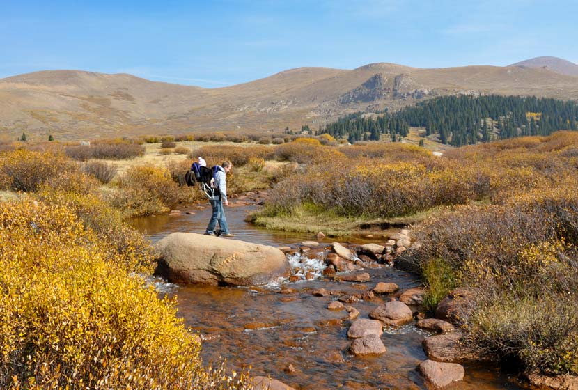
The Bierstadt trail is well marked; you’ll follow signs down to a boardwalk, then to Scott Gomer Creek. After crossing the creek, the trail will become more steep, and the steepness will increase as you make your way to the summit. The trail winds gently through the tundra until you are about three miles in when the green and brown gives way to rock. Follow the west ridge up to the summit of Mount Bierstadt. For a detailed trace and profile of the Mt.Bierstadt route, see this Route #1 Bierstadt profile on 14ers.com.
Make it an Easy Family Hike
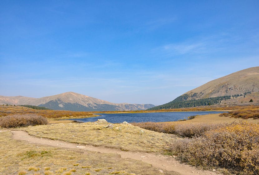
Hiking Colorado’s Bierstadt trail doesn’t mean that you have to summit. In fact, the first mile of trail is really tame. It takes you over a creek, through willows, and by two small high mountain lakes. If you want to gain additional views, you can add another half mile of moderate hiking that will take you above the valley floor.
We took our 4 1/2 year old, 2 year old with us in the Fall and they loved it. Dog’s on the Mount Bierstadt trail must be kept on a leash and need to be kept 100′ from water sources (in short, they aren’t allowed to play in the lakes and streams). In fact, because we’d recommend that you leave Fido at home because of the fragile alpine tundra ecosystem. In August of 2012, Missy, a German Shepherd, was rescued after being stranded on the peak for eight days. You can read more about her ordeal and the rescue in this Denver Post article.
Camping Near the Mt. Bierstadt Trail
There are a lot of campground sites along both sides of Guanella pass that are managed by the forest service (fee required) and dispersed camping is allowed on US Forest and wilderness areas. Below you’ll find a few important links to camping information for the Mt. Bierstadt and Guanella Pass Area.
- Mt. Evans Wilderness Hiking and Camping Regulations.
- Camping Information and Regulations for the US Forest Service
- Guanella Pass Campground
- Burning Bear Campground Near Mt. Bierstadt Trail: Jennifer Mason does a nice job profiling both the Burning Bear and Whiteside campgrounds on her site.(note: Whiteside has been permanently closed)
- For More Campgrounds along Guanella Pass, use the Recreation.gov site and do a search for Guanella Pass Road
Tips & Resources for Hiking the Mt. Bierstadt Trail:
- TIP: Go Early; the parking lot at the Mt. Bierstadt Trailhead fills fast.
- TIP: If you’ve never summited a 14er before, be sure to read this great article by Lindsey Koehler of 5280 Magazine.
- TIP: If you plan to summit Mount Bierstadt, start early so that you can be back at the trailhead before the almost daily summer thunderstorms role in. I’d recommend starting around 6am, so that you’re back at your car around 11am.
- TIP: Hiking times vary. Those who frequently make the assault on Mt. Bierstadt (even trail run it), can make it up and back in 3 hours. The average is 5hrs, but adjust for experience and how good of shape you’re in
- After the Hike: Tommy Knocker Brewery
- TIP: The weather will be cooler at the trailhead than the posted Georgetown, Colorado temperature below. It will be even cooler at the summit of Mt. Beirstadt.
- Trail Map for Guanella Pass: Trail Map Link
- Colorado Road Conditions: Colorado Road Conditions
Weather
Map & Driving Directions to Trailhead for Mt. Bierstadt
Click for Driving Directions


“Mt. Bierstadt is popular, not just because it’s so close to Denver, but it’s also one of the easier and more accessible of Colorado’s 58 fourteen thousand foot peaks.”
By any reasonable objective measure there are 52 14ers, and historically 54 have been recognized (the 52 plus Ellingwood and North Maroon).
“In August of 2012, Missy, a German Shepherd, was rescued after being stranded on the peak for eight days.”
No domesticated animals of any kind have any business on wilderness trails, least of all high traffic trails such as Bierstadt. Above about 12,000 feet, the biome shifts to an incredibly fragile alpine tundra that can be damaged for hundreds of years by an non-native animal, and all the animals hardy enough to live in the area suffer greatly for the stress conferred from introduction of a non-native species. Your domesticated animal can’t tell its on a 14er, so please either leave you companion at home or find a non-ecologically destructive avenue in other, safer trails.
Also keep in mind that at high altitudes you will most likely have greater difficulty controlling your companion animal. I’ve seen many hikers, domesticated, and native animals all harmed when a domesticated animal bolts after a native animal, often harming itself, unnecessarily stressing the native animal, and potentially pulling the hiker into danger. Please be safety conscious at all times while hiking, and don’t expose anyone or anything to unnecessary danger.
Hey Calvin, thanks for the correction on the Fourteeners number. I went in and corrected it. Though we brought our pup with us on a segment of the Bierstadt trail, I’d agree with you, that this trail, and really any trail that in the tundra biome is not the place for domesticated animals. Some folks let their dog loose to swim in one of the high mountain lakes just off the trail and I was cringing. I don’t think most people understand that the oils and shampoos that a dog introduces can be pretty destructive to the fragile ecosystem.
I can’t possibly imagine a leashed dog causing any less impact to the area than the thousands of people who walk on this trail. The tragic story of that dog in the cited article isn’t a normal example of what happens on this trail.
Plenty of domesticated animals share wilderness trails with people without incident or the “danger” you describe.
–Regardless of your opinion, This trail officially allows dogs that are leashed. Plenty of people have and will continue to enjoy this trail with their furry friends responsibly.
If you are bothered by people and dogs, please find another trail than the most trafficked 14er in the state.
We climbed Bierstadt on 9-3-2014. Saw a couple of moose down by the lake near the parking lot, so keep an eye out. My wife could only make it about 20 yards at a time before needing to rest. I don’t think she had any severe case of altitude sickness, but she couldn’t breath because of the thin air. I got her up to almost where the saddle is before she said she would wait for me and let me continue. On the way down I was surprised to find her where I left her, I thought she’d start making her way down but its so pretty up there she wanted to wait for me. The hardest part was the last push up to the summit. It took us at least 8 hours RT, and we were VERY sore. I remember the days when I was in my 20’s and I could have just ran up the hill, but we are both now 55. We only acclimated for a day and a half in Denver and Boulder, and come from a location where our elevation normally is only 900′, but we did alright and we saw about 4 other climbers who gave up. I was surprised by how many other climbers were so friendly and helpful, and I hope that everyone continues this tradition on Mt. Bierstadt.
Bierstadt is a beautiful trail and easily accessible. All this commotion about dogs on the trail is completely unwarranted. A seasoned hiker with a dog on a leash does no more damage to the ecosystem than a solo hiker. What SHOULD be addressed is the amount of casual hikers who go off trail. Because of how close this mountain is to Denver you get columns of people, church vans, and vacation groups all coming and making a joke of the trail. They don’t respect the area or the land, break off switchbacks to save ten feet in distance, litter at the summit, and head off trail to rest or take pictures.
Dogs should be allowed to enjoy summits too, but just as long as their owners take of them. The bigger problem is the lack of respect an overwhelming amount of people have for the mountains. It’s really a shame.
Went last weekend. That was a mistake. Hords of people. Nice moderate hike to the summit but never on a weekend. Way too many people. Someone every 30 or so feet all the way up and down. None of the dogs were on a leash and running all over the place. They were definitely tuned into the pikas. People blasting music from their packs. Hikers running down the tundra instead of the trail. Very sad. Not sure what can be done other than limit the cars to just the parking lot.
Correct link for the article for people never climbed a 14er:
https://www.5280.com/2013/05/the-ultimate-guide-to-hiking-colorados-fourteeners/
Thanks! I’ve updated it above :)