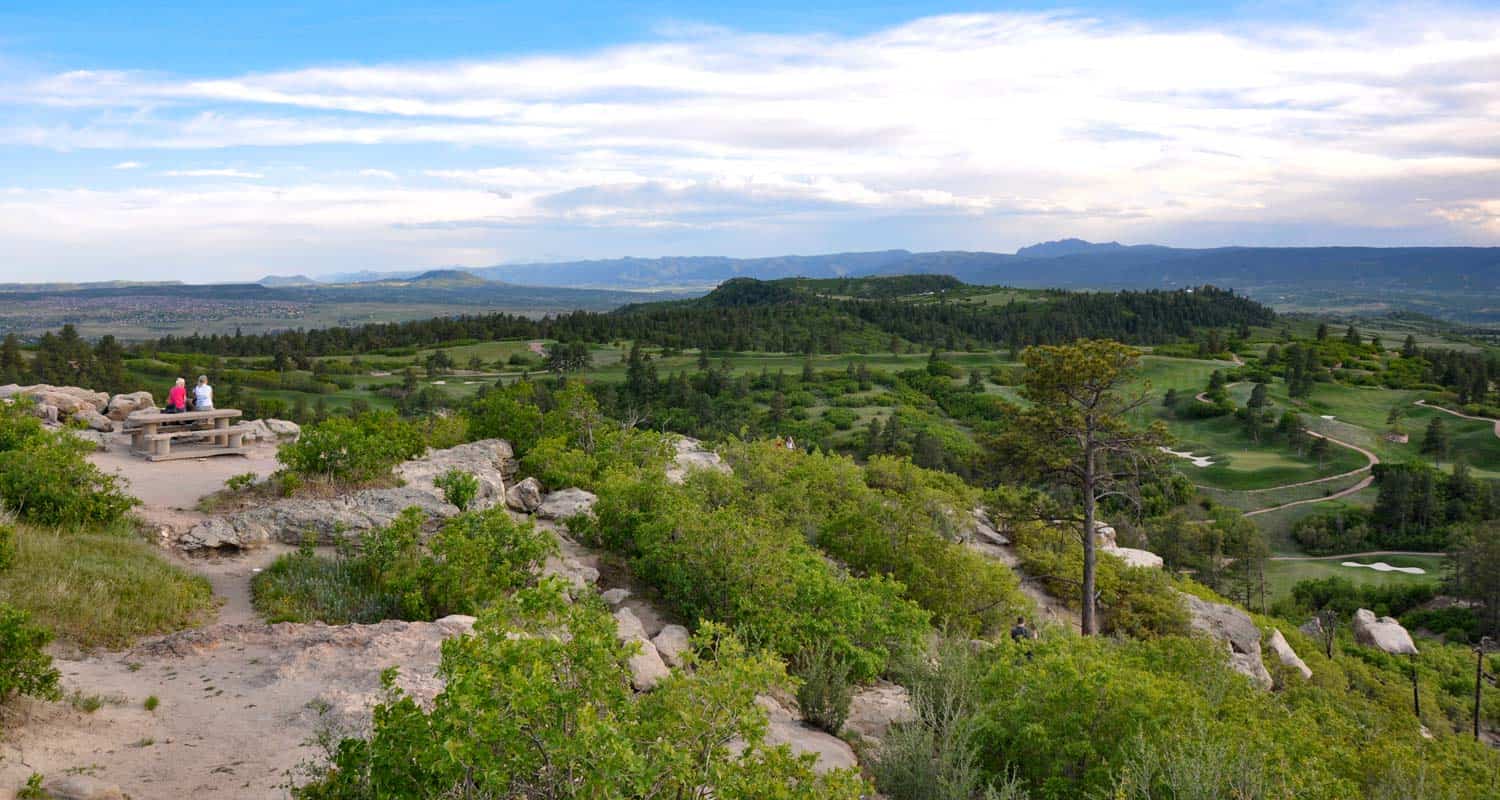
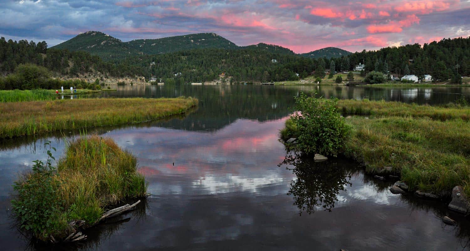
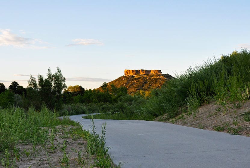
Daniel's Park Hikes
Best sunsets in Denver! You can see mountains upon mountains of Colorado's Front Range. Take a picnic dinner and pull off at one of the many picnic areas along Daniels Park Road. There are several hiking options detailed below for Daniel's park. To get all the details, scroll down and explore the trail snapshot, profile, and tips below.
Trail Snapshot: Daniel's Park Hike
| Hike Distance | 0.2, 3, or 5.4 Miles |
|---|---|
| Difficulty | Easy |
| Duration | 20 min to 2.5 hrs |
| Trail Type | Out and Back |
| Seasons | All Season |
| Dogs | Allowed on Leash |
| Hike Trail Map | Click for a Trail Map |
| Denver Drive Time | 35 min |
| Directions | Click for Google Map |
| Town Nearest Hike | Littleton, Colorado |
| Beauty | Front Range Views, Rock Formations, Bison |
| Activities | Picnic Areas, Shelter House with Fireplace, Bison viewing area, Hiking |
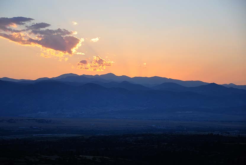
We are featuring Daniel's Park ,not for it's trails, but because it has one of the best views of the Front Range near Denver. From the park, you can see Pikes Peak in the South, Mt. Evans in the West, and Longs Peak in the North. The trails are not handicap accessible, but the shelter house is (after a bit of a bump trail), and is a perfect place to watch the sun set.
Here is the lowdown on the trails at Daniel's Park: They are undeveloped. The park has been around for nearly 100 years but has somehow escaped being developed. However, it's close to south Denver and has some great features, so we've come up with a few different hiking options below.
The Short Daniel's Park Hike - Park at the Shelter House and begin walking north through the undeveloped trails along the top of the bluff. We like to take a picnic dinner up here and a lot of folks bring firewood and enjoy the sunset by the fire. There are about a quarter mile of trails that weave through the rock and back out towards the road.
3 Mile Daniel's Park Hike - Again, start at the Shelter House and head North following the top of the bluff as it parallels the road. You can extend your hike by hiking North along the road until it intersects with Grigs Road - About 1.5 Miles. Hike back to Daniel's Park Shelter House for a 3 Mile round trip hike.
5.4 Mile Daniel's Park Hike - Continue the 1.5 mile hike by taking a left onto Grigs road. Cross to the Northeast side of the Grigs, then shortly after you cross, you'll come upon a green fence and the Douglas County East/West Trail. Your can take that trail West (left) to the Grigs Road Trailhead, adding an additional 1.2 miles to your hike (5.4 Miles Round Trip). Click Here for a Google Map that traces the route along Daniel's Park and Grigs Road.
Douglas County plans to build this East/West trail into a 26 mile system linking Chatfield Reservoir to the town of Parker, Colorado. Click here for the map of the East/West Trail and proposed trails in Douglas County. Denver Mountain Parks and Douglas County have developed a master plan to improve both the park and the roads in the area. You can find an overview at the Douglas County Park site.
Tips & Resources for Visiting Daniel's Park:
- TIP: Keep an eye on the skies - Douglas County has one of the highest lightning strike rates in the country and Daniel's Park is one of the higher points.
- TIP: Bison Viewing - The Bison can be found in an enclosed pasture on both sides of the road.However, the Bison are usually found grazing in the section of the park that is directly across the street from the shelter house.
- Trail Map for Daniel's Park: Trail Map Link
- Colorado Road Conditions: Colorado Road Conditions
Weather
Map & Driving Directions
Click for Driving Directions

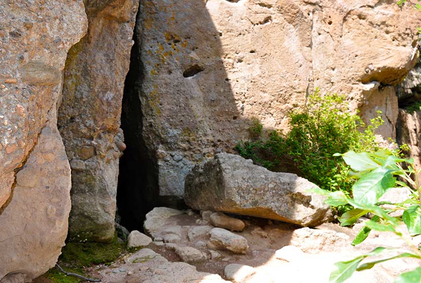
Cave Trail at Castlewood Canyon
Colorado's Castlewood Canyon State Park has several caves hidden in the park, but this set has their own trail. It's a short trail, just a 1/8 mile one-way, but can be combined with other hiking trails--one that takes you to a waterfall--to create a real adventure. Check out the trail snapshot to get the map, driving directions to Castlewood Canyon, and tips for exploring the Cave Trail in Castlewood Canyon.
Trail Snapshot: Cave Trail at Castlewood Canyon
| Hike Distance | 0.14mi (.28mi RT) |
|---|---|
| Difficulty | Moderate due to terrain |
| Duration | Approx 30min Round Trip |
| Trail Type | Out and Back |
| Seasons | All |
| Dogs | Allowed on Cave Trail, But Not on the East Canyon Trail |
| Hike Trail Map | Click for a Map of Cave Trail at Castlewood Canyon |
| Denver Drive Time | 1 hr |
| Driving Directions to Cave Trail at Castlewood Canyon | Click for Google Map |
| Town Nearest Hike | Castle Rock, Colorado |
| Beauty | Cliffs, caves, mature ponderosa pines |
| Activities | Rock climbing, hiking, picnic areas, nearby waterfall |
| Fee Required | Visit Colorado State Parks Site |
Looking for caves close to Denver? They may not be extensive, but they are still fun to explore. There are actually two caves along the top of the trail. One is a kind of large crack in the rock that leads to a larger chamber. I wish I could describe it better, but my 2 1/2 year old, when I asked if she wanted to go inside, was concerned that the "bears might be awake." There are more caves hidden in Castlewood Canyon waiting to be found, but that is for another post.
Tips & Resources for Hiking Cave Trail at Castlewood Canyon :
- Finding the Trail: The cave trail can be accessed by hiking across the dirt road from the parking lot. The Google Map is very specific and should be helpful in finding the correct parking area.
- Add the Waterfall: The Waterfall Hike can be added to your trip. Midsummer raspberries can be found above the falls along the trail.
- Finding the Traihead: The West Side entrance can be difficult to find. Usually, Colorado State Parks have brown signs indicating the park roads. The west side doesn't. But the name of the road you're looking for is "Castlewood Canyon" - easy to remember.
- Short but Steep Hike: The hike is easy when you consider the distance, but we rated this one as difficult because the trail can be quite uneven and very steep. Watch your footing.
- Make it a Loop Hike: You can make an even larger loop out of the hike by exiting on either the north or south end of the Cliff Base or Climber's Trails, then crossing the road east to one of the parking areas. From there, take the West Side Spur or the Creek Bottom Trail back to your car. See the Castlewood Canyon Map below for details.
- TIP: Hikes in Castlewood Canyon can be quite exposed to the sun, so bring the sunscreen.
- TIP: Poison Ivy: We've been surprised how poison ivy flourishes in this park, often along the edge of the trail. Know how to identify it, so that you can avoid it. But don't let that deter you from the park. You just need to keep an eye out. See our post on how to identify and treat poison ivy.
- Trail Map for Castlewood Canyon: Trail Map Link
- Additional Maps: Castlewood Canyon State Park Trails
- Colorado Road Conditions: Colorado Road Conditions
- After the Hike: Crowfoot Valley Coffee
Weather
Map & Driving Directions
Click for Driving Directions
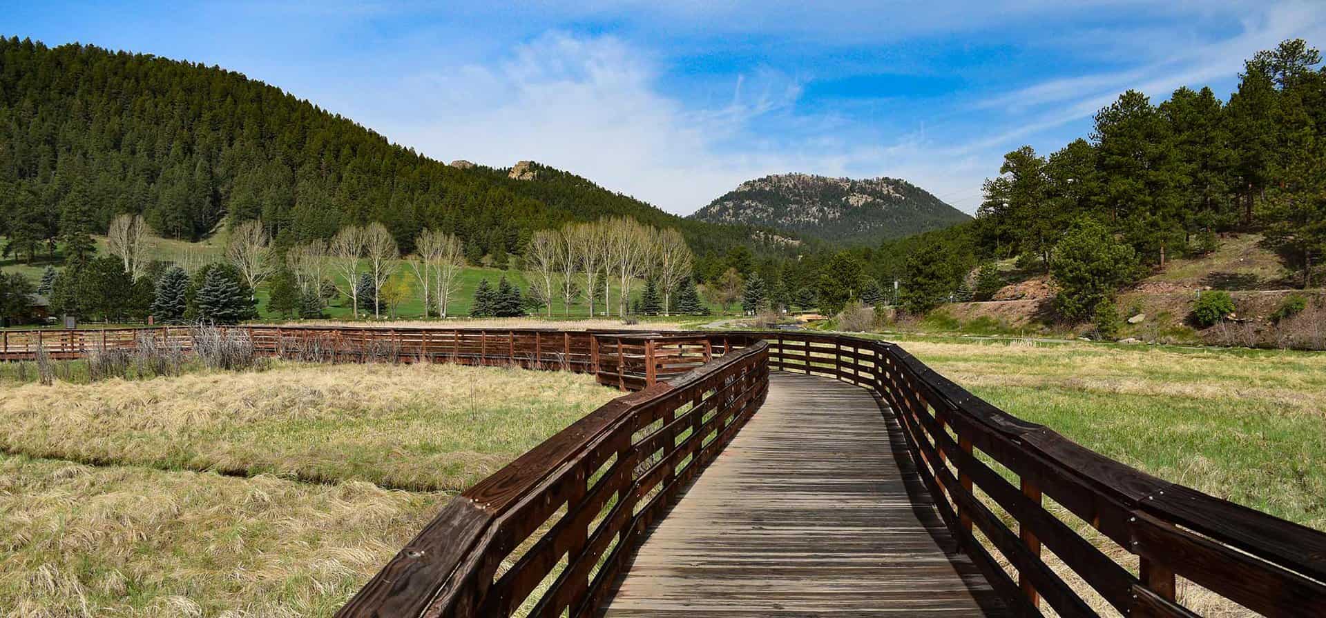
Evergreen Lake Trail
This Colorado hike (more of a stroll) is a perfect way to spend a Saturday morning. You can rent canoes and sailboats from the nature center and warming house. In the winter, the Evergreen Lake transforms into an ice skating wonderland. Explore this hike profile for all the details.
Trail Snapshot: Evergreen Lake Trail
| Hike Distance | 1.3 mile Round Trip |
|---|---|
| Difficulty | Easy |
| Duration | Approx 45 min Round Trip |
| Trail Type | Loop |
| Seasons | All |
| Dogs | Allowed On Leash |
| Hike Trail Map | Click for a Trail Map |
| Denver Drive Time | 40 min |
| Driving Directions to Evergreen Lake Trail | Click for Google Map |
| Town Nearest Hike | Evergreen, Colorado |
| Beauty | Lake, sunsets, wetlands, wildlife: elk & migratory birds |
| Activities | Picnic area, hiking trails, boating, fishing, ice skating |
| Handicap Accessible | Portions of this Trail are Handicap Accessible |
The Hike: Evergreen Lake Trail:
Evergreen Lake Trail is a 1.3 mile loop in the quaint mountain town of Evergreen, Colorado. If you have a young family like us, and are looking for an easy hike near Denver, this is a great choice.
From the Evergreen Lake house, the trail winds along a boardwalk, through a wetlands area, then towards town. If you are going this way (clockwise) around the lake, be sure to take the high path when you come to where the trail splits. The lower path is more of a fishing trail that soon becomes difficult to navigate. You can take the high path into town or over the dam and to the backside of the lake.
Along the back side of Evergreen Lake stands the old Warming House and Nature Center, operated by the Evergreen Audubon Society. Be sure to check their site for their seasonal hours. At the boathouse, the Evergreen Park & Recreation District operates boat rental and concessions. Their hours are seasonal as well. You can visit Evergreen Parks & Rec. boating page for rental info and hours. In the Winter, the lake transforms into an ice skating wonderland that rivals New York's Rockefeller Square. Skate rental and admission fees can be found on the Hockey and Skating page on the Evergreen Parks District Site.
Tips & Resources for Hiking Evergreen Lake Trail :
- TIP: Like we mentioned above, take the high path along the road when walking clockwise around the lake.
- TIP: Make it a day. There are several hikes near Evergreen to enjoy. As well, the lake is very accessible from town, so you can walk in, enjoy lunch or coffee, then hike back out.
- TIP: Listen for Elk in the Fall: On our most recent trip to Evergreen Lake, a bull elk was bugling. So, if you just don't have time to make it up to Estes Park, this is a great backup.
- Trail Map for Evergreen Lake Trail: Trail Map Link
- Colorado Road Conditions: Colorado Road Conditions
- After the Hike: Beau Jo’s Pizza
Weather
Map & Driving Directions
Click for Driving Directions

Chimney Gulch Trail at Windy Saddle Park
It's a demanding hike up Chimney Gulch near Golden, Colorado, but the views at the top are worth the workout. This hiking trail crosses streams as it zigzags up the side of local landmark, Lookout mountain. Explore the full Chimney Gulch hike profile below for trail map, driving directions, and more tips and details to help you enjoy this adventure in Windy Saddle Park.
Trail Snapshot: Chimney Gulch Trail at Windy Saddle Park
| Hike Distance | 5 miles Round Trip |
|---|---|
| Difficulty | Moderate to Difficult |
| Duration | Approx 2.5+ hrs |
| Trail Type | Out and Back |
| Seasons | All Season |
| Dogs | Allowed On Leash |
| Hike Trail Map | Click for a Map of Chimney Gulch Trail Map |
| Denver Drive Time | 25 min |
| Driving Directions to Chimney Gulch Trailhead | Click for Google Map |
| Town Nearest Hike | Golden, Colorado |
| Beauty | Rocky Mountain vista at top, views of Golden & Denver |
| Activities | Hiking, mountain biking, trail running |
The Hike: Chimney Gulch Trail
Steep - that's probably the best adjective for this hike. The trail is very accessible from Denver - on average, just a 25 minute drive. The trail begins at the base of Lookout Mountain in Golden and weaves it's way to the top, crossing the road twice, to a wonderful mountain vista. It's a perfect place, complete with benches, for viewing sunsets. However, a hike down in the twilight may be pretty difficult to negotiate. The Chimney Gulch Trail joins up with both the Beaver Brook Trail, and Lookout Mountain Trail. See the link to the trail map above for details.
Tips & Resources for Hiking the Chimney Gulch Trail
- TIP: Because the trail can be narrow and has a lot of mountain bike traffic, we suggest leaving the dog at home.
- TIP: If you want to start at the top, you can park at the Windy Saddle Trailhead along Lookout Mountain Road. Click for Google map and driving directions.
- Adjust Expectations: If you are hoping for a quiet, solitary hike, this is probably not the best choice. Because this trail is very accessible and challenging, there is a lot of hiking, running, and biking traffic.
- For a great detailed trail description: , check out Deb Stanley's Chimney Gulch Trail profile.
- Trail Map for Chimney Gulch Trail: Trail Map Link
- Packing List: Always pack the 10 Essentials. Download our Hiking Guide to get the list and dayhiking packing checklist.
- Colorado Road Conditions: Colorado Road Conditions
- After the Hike: Cafe 13
Weather
Map & Driving Directions for Chimney Gulch Trailhead
Click for Driving Directions
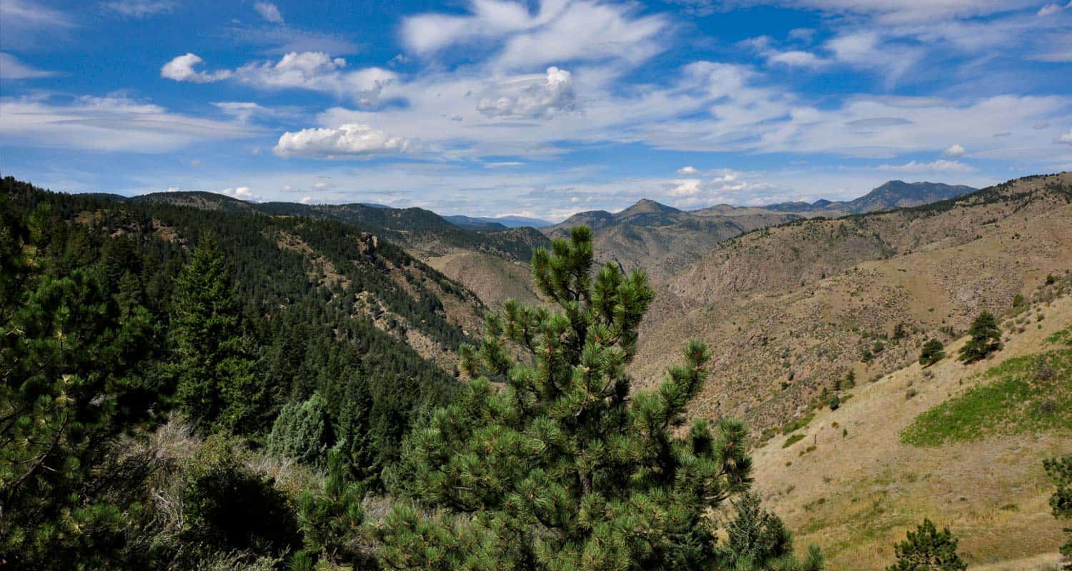
Forgotten Valley Hike at Golden Gate State Park
Can you think of a more mysterious name for a hike? Colorado's Golden Gate State Park has many trails, and the Forgotten Valley is a great place to start discovering this gem that is tucked between Golden and Boulder, Colorado. Get all the details on hiking the Forgotten Valley by scrolling down to the hike snapshot and hiking tips below.
Trail Snapshot: Forgotten Valley Hike at Golden Gate State Park
| Hike Distance | 3 miles Round Trip |
|---|---|
| Difficulty | Moderate |
| Duration | Approx 2.5 hrs+ Round Trip |
| Trail Type | Out and Back |
| Seasons | Spring through Fall |
| Dogs | Allowed On Leash |
| Hike Trail Map | Click for a Map of Golden Gate State Park |
| Denver Drive Time | 55 min |
| Driving Directions to Forgotten Valley Hike at Golden Gate State Park | Click for Google Map |
| Town Nearest Hike | Golden, Colorado |
| Beauty | Pond, old homestead ruins, wildlife: mule deer, golden eagle, Abert's squirrel, Steller's jay |
| Activities | Hiking trails, fishing, backcountry camping, visitors center |
| Park Fee Required | Click For Info |
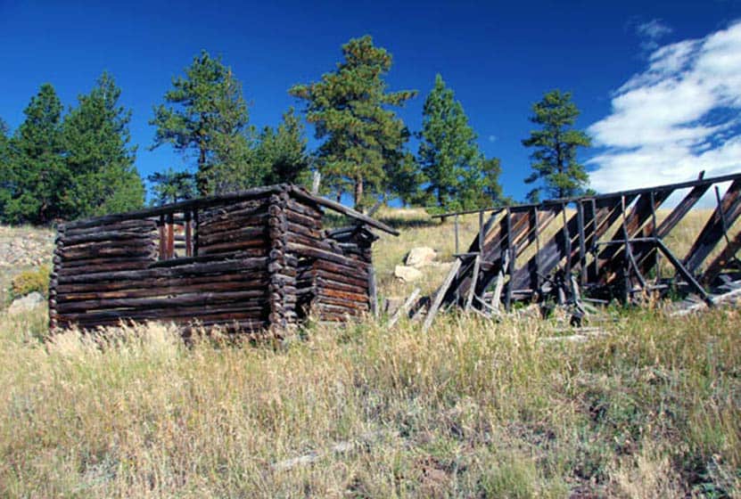
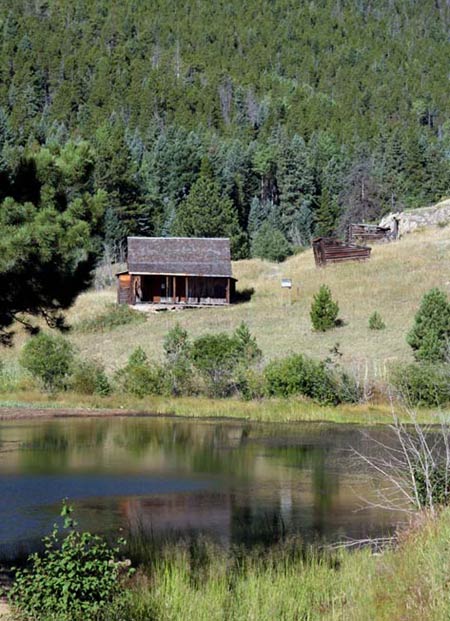
The Forgotten Valley in Golden Gate Canyon State Park is a step back in time.This day hike near Denver takes you 1.5 miles to an old homestead complete with front porch views of the small lake that sits in the bottom of the valley. From the Bridge Trailhead, take the Burro Trail for approximately 3/4 of a mile to where it intersects with the Mountain Lion Trail. Turn North (Left) on the Mountain Lion Trail, and follow that for about 3/4 of mile to Forgotten Valley and the Tallman Homestead. The pond in the valley is stocked by the division of wildlife. We want to thank Kenny Chaffin for his photo of the Tallman Homestead. You can view more of his Denver area photos here.
Tips & Resources for Hiking Forgotten Valley Hike at Golden Gate State Park :
- TIP: Pick up a Trail Map at the Golden Gate Canyon State Park Visitors Center.
- TIP: Parking at the Bridge Trailhead is very limited, so go early.
- TIP: There are some great options on this hike. Grab a Trails Illustrated Boulder/Golden Map and hike to the top of nearby Windy Peak or hike the entire Mountain Lion Trail Loop.
- Trail Map for Golden Gate Canyon State Park: Trail Map Link
- Colorado Road Conditions: Colorado Road Conditions
- After the Hike: Windy Saddle Cafe
Weather
Map & Driving Directions
Click for Driving Directions
East Plum Creek Trail in Castle Rock
This paved trail meanders along Plum Creek in Castle Rock, Colorado. Though it winds through developed areas, the Plum Creek trail has some surprises: towering cottonwoods, pines, and the seasonal sounds of Plum Creek. Be sure to explore snapshot and full hiking profile below to get the details on parking, trail map, and hike options.
Castle Rock is a growing community South of Denver and not without it's some great hikes. Be sure to explore the many trails out in Castlewood Canyon State Park, and our hikes near Castle Rock, Colorado page.
Trail Snapshot: East Plum Creek Trail in Castle Rock
| Hike Distance | 6 miles of trail |
|---|---|
| Difficulty | Easy |
| Duration | Approx 30 min to 4 hrs |
| Trail Type | Out and Back |
| Seasons | All |
| Dogs | Allowed On Leash |
| Hike Trail Map | Click for a Map of East Plum Creek Trail in Castle Rock |
| Denver Drive Time | 35 min |
| Driving Directions to East Plum Creek Trail in Castle Rock | Click for Google Map |
| Town Nearest Hike | Castle Rock, Colorado |
| Beauty | Cottonwoods, meadows, wetlands, wildlife: Preble's meadow jumping mouse, beavers, migratory birds |
| Activities | Hiking, running, biking, birdwatching |
The East Plum Creek Trail winds through the heart of Castle Rock, Colorado, through wetlands, and along the banks of Plum Creek. Starting from the Meadows Parkway lot, you can head North for 1.8+ miles through cottonwoods and between two historic railways. If you head south along the trail from the Meadows lot, the trail will take you into a wetland habitat where beavers build and migratory birds rest. Follow the trail south for 3 miles and all the way into town for a 6 mile round trip.
Tips & Resources for Hiking East Plum Creek Trail in Castle Rock:
- TIP: One can take a close-up look at the unique wetland habitat along the East Plum Creek and lower Sellars Gulch, which are great locations to go bird watching.
- TIP: Parking is available at the Meadows Parkway. There are additional parking areas at Festival Park and along South Perry Street.
- Trail Map for East Plum Creek Trail: Trail Map Link
- Colorado Road Conditions: Colorado Road Conditions
- After the Hike: Crowfoot Valley Coffee
Map & Driving Directions
Click for Driving Directions
Meadow & Forest Loop Trails at Lookout Mountain Nature Center
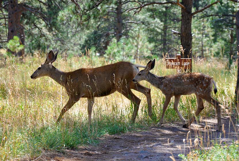
If you are looking for a family hike near Denver, this is a perfect trail, especially if you are getting started hiking with your kids in Colorado and want to guarantee a good experience. It's short, there's wildlife, and the Lookout Mountain Nature Center. Take a picnic lunch, just watch out for the squirrels; they'll run of with your dessert if you don't watch them closely. Explore the full Meadow & Forest Loop Trails hike profile below for trail map, driving directions, and more tips and details to help you enjoy this family adventure.
| Hike Distance | 0.6 & 0.8 Mile Loops |
|---|---|
| Difficulty | Easy |
| Duration | Approx 30 min |
| Trail Type | Loop |
| Seasons | Hours Vary |
| Dogs | Not Allowed |
| Hike Trail Map | Click for a Map of Meadow & Forest Loop Trails at Lookout Mountain Nature Center |
| Denver Drive Time | 30 min |
| Driving Directions to Lookout Mountain Nature Center | Click for Google Map |
| Town Nearest Hike | Golden, Colorado |
| Beauty | Front Range views, ponderosa pine, wildlife: Abert's squirrels, and deer |
| Activities | Hiking, nature center, picnic area, birdwatching |
Lookout Mountain Nature Center has 2 short loop hikes. If you have young children, this is a perfect trip. The trails at Lookout Mountain are short loops: 1- The Meadow Loop (.8 mile) & 2 - Forest Loop Trail (.6 mile). If you are looking for a longer hike, you can cross the street and take the Lookout Mountain Trail which connects to several other Jefferson County Parks and trails.
The nature center is a great place for your kids to learn about Colorado wildlife. The playroom has texture sames of bark, fur, animal tracks, and the biggest box of stuffed animal puppets you'll ever see. The last time we visited, our daughter didn't want to leave. Take a lunch and have a picnic under the towering Ponderosa Pines. We encountered 2 deer with their fawns along the Forest Loop trail. The immediate area around the nature center is handicap accessible.
Tips & Resources for Hiking Meadow & Forest Loop Trails at Lookout Mountain Nature Center
- TIP: If you take Lookout Mountain Road from Golden, it's a beautiful drive. However, on the weekends, this road has a ton of cycling traffic. So, plan for a slow drive.
- TIP: Visit the Boettcher Mansion next door
- Trail Map for Lookout Mountain Nature Center: Trail Map Link
- Packing List: Always pack the 10 Essentials. Download our Hiking Guide to get the list and dayhiking packing checklist.
- Colorado Road Conditions: Colorado Road Conditions
- After the Hike: Louis’ Cafe
Weather
Map & Driving Directions
Click for Driving Directions
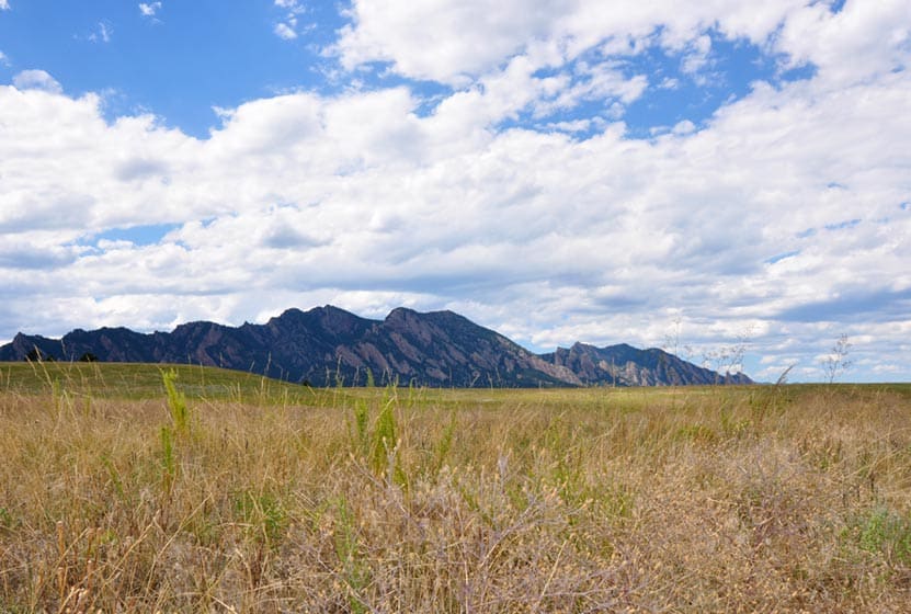
Flatirons Vista Loop Trail
If you are yearning for wide open spaces, the Flatirons Vista trail near Boulder, Colorado makes for a perfect hike. The trail has two loop options and links up to other hiking trails along the Flatirons. Explore the trail profile of this classic Colorado hike for a trail map and all the details like driving directions, trail difficulty rating, and distances.
Trail Snapshot: Flatirons Vista Loop Trail
| Hike Distance | 1.9 or 3.3 Miles |
|---|---|
| Difficulty | Easy to Moderate |
| Duration | 1 to 2.5 hrs |
| Trail Type | Loop |
| Seasons | All Season |
| Dogs | Allowed on Leash |
| Hike Trail Map | Click for a Trail Map |
| Denver Drive Time | 40 min |
| Directions | Click for Google Map |
| Town Nearest Hike | Boulder, Colorado |
| Beauty | Views of the Flatirons, Meadows, Ponderosa Pines, Wildlife: Bobcat, Bear, Mule Deer, Eagles (in winter), & coyote |
| Activities | Hiking Trails, Horseback Riding, Mountain Biking, Birdwatching, & Trail Running |
| Fee | $5 Parking fee or $25 Annual Pass |
You've got options. The Flatiron Vista Loop trail offers 2 loops. One is 3.3 miles and the other is just 1.9 miles. They will wind you through the ponderosa pines and meadows that skirt of the famous Flatirons just south of Boulder. It's an easy hike and a trail runner's dream. The Flatiron Vista Loops are a great destination for winter hikes as well. That's the time of year that you are likely to spot both Golden and Bald Eagles.
The Loops:
-
Longer Flatiron Vista Loop -3.3 miles:
Take the South Flatiron Vista trail (about .2 miles down the trailhead connector trail). After 2.4 miles, bear right onto the North Flatiron Vista Trail. Then, after 1 mile, take the connector trail you came in on back to the trailhead. (reverse this if you like).
-
Shorter Flatiron Vista Loop -1.9 miles:
Take the South Flatiron Vista trail (about .2 miles down the trailhead connector trail). After approx. 1 miles bear right onto Prairie Vista Trail. Continue about 1 mile, then take the connector trail you came in on back to the trailhead

Tips & Resources for Hiking at Flatirons Vista:
- No Shade: The trails at Flatirons Vista are very exposed. Bring a hat and use the sunscreen.
- Trail Map for Flatirons Vista Trail: Trail Map Link
- Colorado Road Conditions: Colorado Road Conditions
- After the Hike: Windy Saddle Cafe
Weather
Map & Driving Directions
Click for Driving Directions
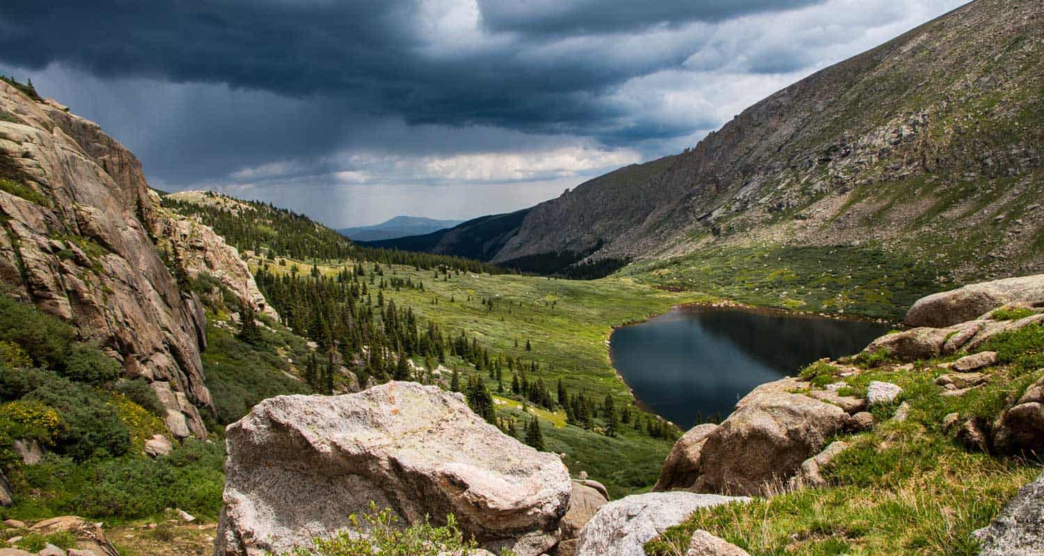
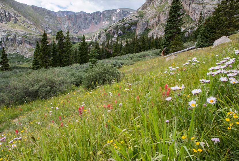
Chicago Lakes Hike Near Mt. Evans
Want to take in some of Colorado's breathtaking scenery and put some miles under your hiking boots? The Chicago Lakes hike begins at Echo Lake. You'll pass three more mountain lakes as you punch up into the high country of Colorado's Mt. Evan's Wilderness. Explore the full trail profile below for the Chicago Lakes which includes driving directions, map, and tips.
Trail Snapshot: Chicago Lakes Hike Near Idaho Springs, Colorado
| Hike Distance | 8.4 to approx 10 miles RT |
|---|---|
| Difficulty | Difficult |
| Duration | Approx 5-7hrs |
| Trail Type | Out and Back |
| Elevation Gain | Approx +1200′ |
| Seasons | Summer to Fall |
| Dogs | Allowed On Leash |
| Hike Trail Map | Click for a Map of Chicago Lakes |
| Denver Drive Time | 1 hr |
| Driving Directions to Chicago Lakes Trail | Click for Google Map |
| Town Nearest Hike | Idaho Springs, Colorado |
| Beauty | Lakes, Mountain Peak Views, Creek, High Country, Cliffs, Wildflowers, & Wildlife: Mountain Goats, Bighorn Sheep, Elk |
| Activities | Hiking, wildlife viewing |
| Weather for Mt. Evans | Click Here |
Looking for amazing views and some high mountain lakes near Denver? This challenging hike takes you to two high mountain lakes with amazing views of the Mt. Evans Wilderness area. Both lakes can be fished, as well as the lower Idaho Springs Reservoir that you pass on your way. We are not into giving long trail descriptions on Dayhikes Near Denver, but we'd suggest you read the basic one below and check out the trail description and pdf Chicago Lakes map link in the trail profile below.
The Chicago Lakes Trailhead and Trail: Park at the Echo Lake lot, where you'll find the sign for Chicago Lakes Trail 52 on the west side of the lake. That will lead you to another sign about .5 mile later directing you to the trail. The trail will turn into Idaho Springs Reservoir Road, then will return to a normal trail. It climbs through a burn area, the result of a fire in the 1970s, then continues to climb to Lower Chicago lake. The trail has a lot of character: steep areas, massive cliff walls, and expansive meadows. The trail continues, faint at times, up a steeper section to Upper Chicago Lake.
As you'll see in the comments on this hike, people come back with different trail lengths. So, to clear this up: Beginning at Echo Lake, the trail is 4.24 miles one-way to the lake. However, most people don't want to stop there, many continue on to the upper lake, which adds and additional .6 mile to the trail. Then, some people opt to hike around the lake, which adds to the hike as well. You may want to start early, especially in the Summer months so that you have the time to explore and to avoid our famous, afternoon Colorado thunderstorms.
Tips & Resources for Hiking Chicago Lakes Near Mt. Evans, Colorado :
- TIP: Don't Miss: 1 - The Upper Lake & 2 - The Cascade between the two lakes
- TIP: Check the Weather before heading up. Use the following link to National Weather Service page for Mt. Evans
- TIP: Look Over trail descriptions from Deb Stanley & David Day before heading out.
- Trail Map for Chicago Lakes Near Mt. Evans: Trail Map Link
- Colorado Road Conditions: Colorado Road Conditions
- After the Hike: Finish your hike by enjoying a slice of Barbara Day's famous pie at Echo Lake Lodge
- Photo: We would like to express our gratitude to Shea Oliver for sharing such an amazing photograph of this hike.
Weather
Map & Driving Directions
Click for Driving Directions

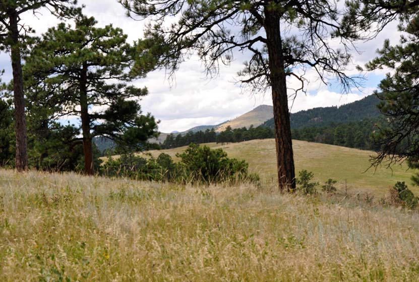
Canyon Loop Trail - Betasso Preserve, Boulder
This hike at Betasso Preserve near Boulder, Colorado makes for a perfect evening escape to watch the sunset over the town below. You'll cross through meadows dotted with wildflowers then under stands of Ponderosa pine that eventually open up to views to east. Explore the hiking trail profiles and map link below for details.
Trail Snapshot: Canyon Loop Trail at Betasso Preserve
| Hike Distance | 3.3 Miles |
|---|---|
| Difficulty | Moderate |
| Duration | Approx 1.5 hr |
| Trail Type | Loop |
| Seasons | All Season |
| Dogs | Allowed on Leash |
| Hike Trail Map | Click Here for a Trail Map |
| Denver Drive Time | 50 min |
| Directions | Click for Google Map |
| Town Nearest Hike | Boulder, Colorado |
| Beauty | Views of Boulder, Wildlife: Aberts Squirrel & Deer, Ponderosa Forest, Meadows |
| Activities | Picnic Area, Horseback Riding, Mountain Biking, Hiking Trails |
Tips & Resources for Hiking the Canyon Loop at Betasso Preserve :
- Easier Approach: Make your hike at Betasso Preserve a bit easier by starting from the East Trailhead
- Mountain Bikers: Each month the direction of travel required for Mountain Bikers is switched. Check the sign at the trailhead. Additionally, biking is not allowed on Wed. & Sat.
- Hikers: Check the sign at the trailhead as well and try to hike the opposite direction of the bike traffic.
- Trail Map for Betasso Preserve: Trail Map Link
- Colorado Road Conditions: Colorado Road Conditions
- After the Hike: Ozo Coffee in Boulder
Weather
Map & Driving Directions
Click for Driving Directions