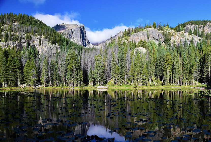
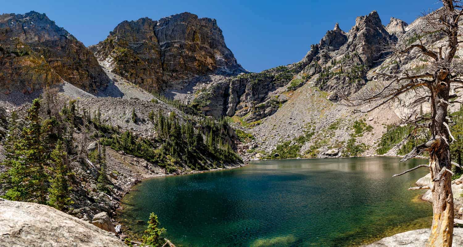
Nymph Lake Hike in Rocky Mountain National Park
In Summer, Nymph Lake in Rocky Mountain National Park blooms with the yellow blossoms of the lily pads that cover its surface. It's a short easy hike from the Bear Lake Trailhead to Nymph lake. Most hikers will want to make the journey beyond Nymph to Dream and Emerald Lakes. Explore the full trail profile below for all the destinations and details: trail map, tips, and driving directions to the trailhead.
Note: Rocky Mountain National Park now requires timed entry permits from May 27th through October 10th. See the RMNP permits page for more information.
Trail Snapshot: Nymph Lake in Rocky Mountain National Park
| Hike Distance | 1 mile Round Trip |
|---|---|
| Difficulty | Easy |
| Duration | Approx 40 min Round Trip |
| Trail Type | Out and Back |
| Starting Elevation | 9475' at Trailhead |
| Elevation Gain | Approx. +225' |
| Seasons | Spring through Fall, Winter Snowshoeing |
| Dogs | Prohibited in RMNP |
| Hike Trail Map | Click for a Map of Nymph Lake RMNP |
| Denver Drive Time | 2 hr |
| Driving Directions to Bear Lake Trailhead | Click for Google Map |
| Town Nearest Hike | Estes Park, Colorado |
| Beauty | Sub-alpine lakes, mountain views, wildlife: Abert's squirrel, ducks, bear |
| Activities | Picnicking, hiking trails, snowshoeing |
| Conditions at Bear Lake Trailhead | Click Here |
| Fee | Park Pass Required |
Parking & Trailhead Information
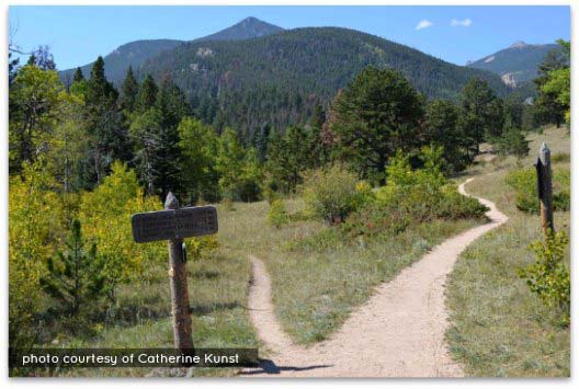
The trail up to Nymph Lake begins at the Bear Lake Trailhead (driving directions).In the event that parking lot at Bear Lake is full, you'll then need to park at the Park & Ride near the Bierstadt Trailhead and take the bus into the trailhead. This service runs 7am to 7PM and more information on the RMNP shuttle bus routes can be found at this link. The trail to Nymph Lake is located on your way to Bear Lake, off to the left, just before reaching the shore viewing area of Bear Lake.
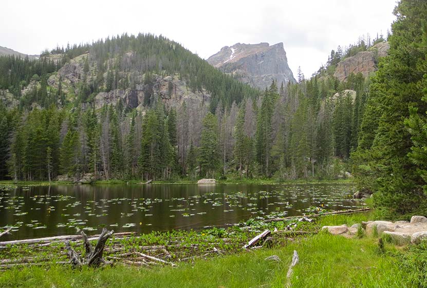
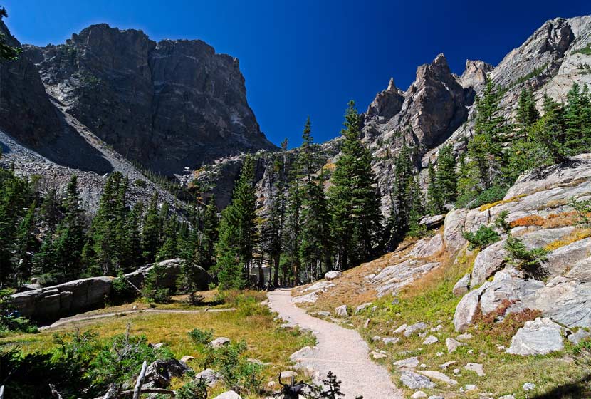
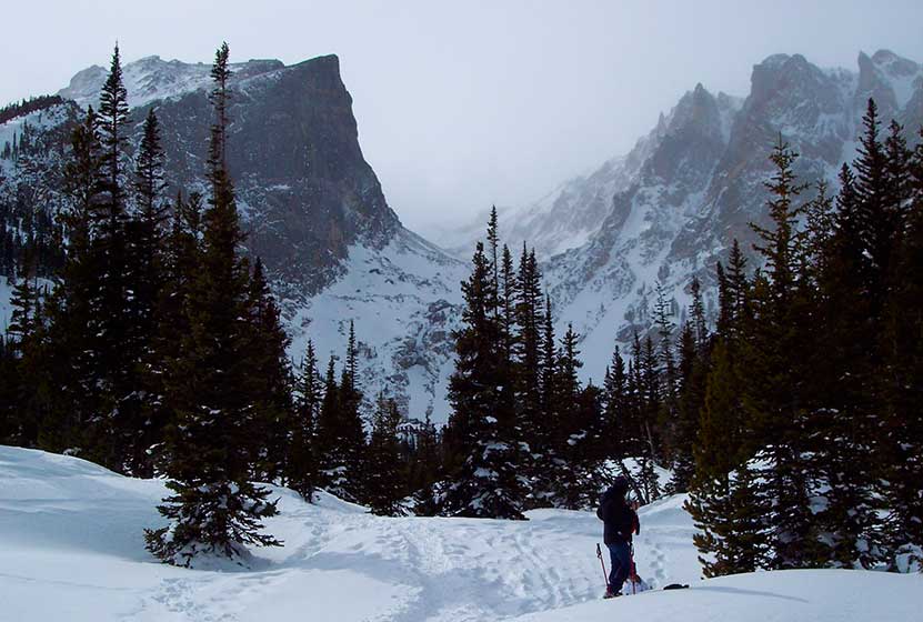
The hike up to Nymph Lake is one of the least demanding--but still rewarding--destinations in Rocky Mountain National Park. Most hikers make the Lake a stopping point on their journey on the longer, 3.6 mile round-trip hike to Emerald Lake. However, Nymph Lake is not without its attractions. In the summer, after the snow and ice have melted, the yellow pond lily fills the lake and bursts with yellow blooms. In the Winter, the Lake, being a smaller body of water (less than 1/5th the size of Dream Lake), freezes over, and Park Rangers will lead snowshoers across it's frozen waters.
The half-mile trail from Bear Lake to Nymph has been improved with asphalt. However it's not exactly wheelchair accessible. The trail was paved in order to absorb the impact of the numerous visitors who hike from Bear Lake to Nymph lake every day. The asphalt ends at Nymph and returns to a dirt trail, meandering through the woods to Dream and Emerald Lakes. At the Lake, hikers can take in some of the iconic scenery of Rocky Mountain National Park. Hallet Peak and Flattop Mountain loom in the distance. Go early in the morning for the most best photography opportunities, and be sure to explore the trail profiles below for the beautiful destinations beyond Nymph Lake.
List and Links of Destinations From Bear Lake to Emerald Lake
1. Bear Lake
2. Nymph Lake - @ .5 miles
3. Dream Lake - @ 1.1 miles
4. Emerald Lake -@ 1.8 miles

Tips & Resources for Hiking to Nymph Lake :
- Explore More: Beyond Nymph lake, you'll find Dream lake (+.6 mile) and Emerald Lake (+.6 mile from Dream Lake).
- Trail Map for Bear Lake Corridor: Trail Map Link
- Conditions at Bear Lake: Click to View Current Conditions
- Colorado Road Conditions: Colorado Road Conditions
- Photo: We would like to express our gratitude to Pete Sheffield for sharing such an amazing photograph of this hike.
- After the Hike: Poppy's Pizza
Weather
Map & Driving Directions
Click for Driving Directions

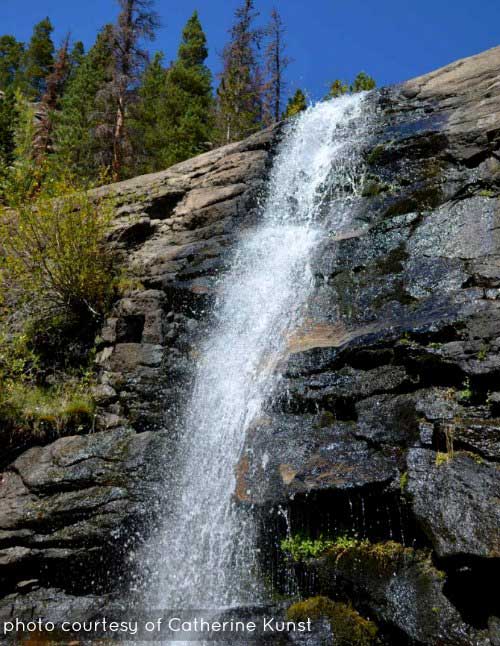
Lake of Glass Waterfall in Rocky Mountain National Park
If you are up for a demanding hike in Rocky Mountain national Park, with 3 waterfalls in the space of less than 5 miles, then the hike up to Lake of Glass Falls is a great choice.
A hidden waterfall that you won't find on the map! Lake of Glass falls is a segmented cascade spilling into the creek that soon becomes Timberline Falls. This relatively demanding hike in Rocky Mountain National Park begins at the Glacier Gorge trailhead, and takes you past two larger waterfalls on your 4.2 mile journey to Lake of Glass Falls.
Note: Rocky Mountain National Park now requires timed entry permits from May 27th through October 10th. See the RMNP permits page for more information.
Trail Snapshot: Lake of Glass Falls in Rocky Mountain National Park
| Hike Distance | 8.4 miles Round Trip |
|---|---|
| Difficulty | Difficult |
| Duration | Approx 5hr+ Round Trip |
| Trail Type | Out and Back |
| Starting Elevation | 9240' at Trailhead |
| Elevation Gain | +1600′ |
| Seasons | May-September |
| Dogs | Prohibited in RMNP |
| Hike Trail Map | Click for a Map of Lake of Glass |
| Denver Drive Time | 2 hr |
| Driving Directions to Glacier Gorge Trailhead | Click for Google Map |
| Town Nearest Hike | Estes Park, Colorado |
| Beauty | Waterfalls, lakes, breathtaking views, wildlife: elk, deer, birds |
| Activities | Hiking, fishing, photography |
| Fee | Park Pass Required |
Parking & Trailhead Information
The trail up to Lake of Glass Falls begins at either the Glacier Gorge Trailhead (see driving directions above), or at the Bear Lake Trailhead (driving directions). Because the Glacier Gorge Trailhead has a much smaller lot, you may need to drive further up to Bear Lake. There you'll find a short connector trail that will put you on the path down and over to the Glacier Gorge Trail system. In the event that parking at Bear Lake is full, you'll then need to park at the Park & Ride near the Bierstadt Trailhead and take the bus into the trailhead. This service runs 7am to 7PM and more information on the RMNP shuttle bus routes can be found at this link.
The Hike to Lake of Glass Falls
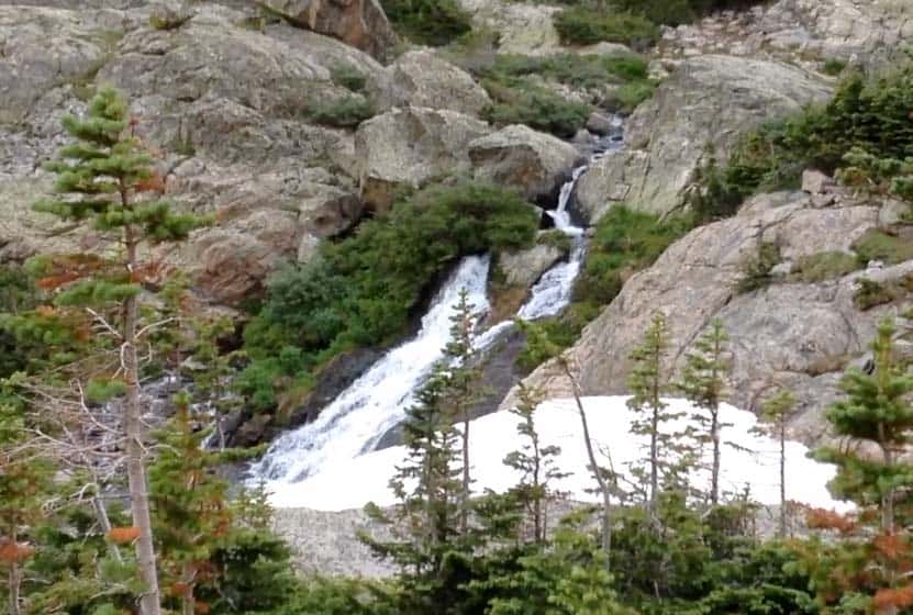
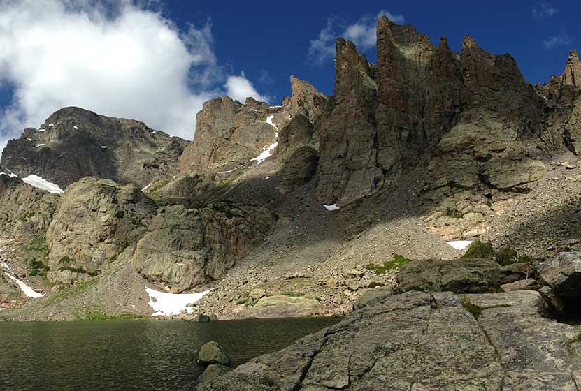
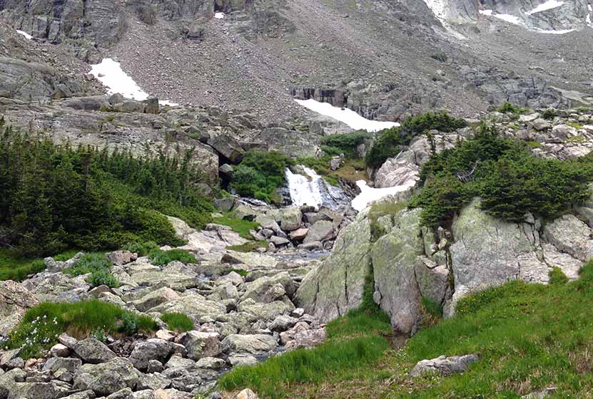
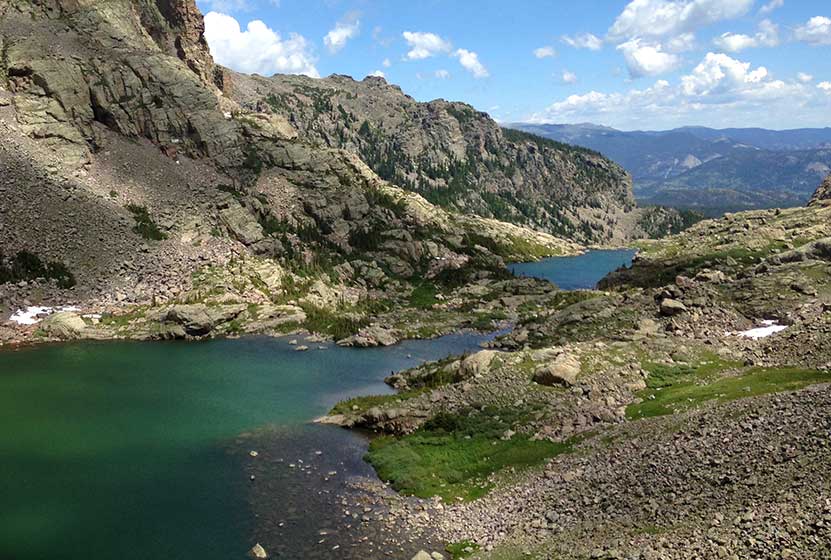
The first destination that you can't and don't want to miss is at .8 miles, Alberta Falls. The trail then climbs toward an eventual trail junction. The way to the Lake of Glass Falls is to follow the Glacier Gorge/Loch Vale trail that bears right and ascends for about another .5 mile to a second trail junction. At this second junction, the middle of the three trails leads onto the Loch Vale Trail, and up to the Loch, Timberline Falls (pictured below), then to Lake of Glass Falls, and eventually beyond to Sky Pond.
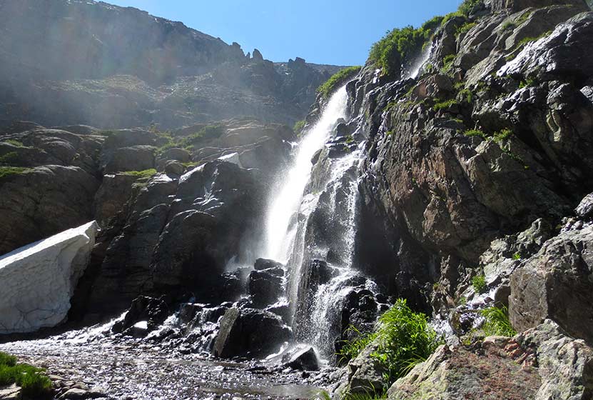
At Timberline Falls (pictured above), the trail up to Lake of Glass Falls is a steep scramble to the right-side of the waterfall. Be aware, the rock may be slick and this area is very steep. Hikers should have good footwear, and may need to be patient for those who are descending this section of the trail. In most of this segment, there is only room for one hiker at a time to safely negotiate the scramble. Many hikers will find the descent of this short portion of the trail more difficult than the way up.
Lake of Glass Falls can be seen trailside, on your left, after the "timberline scramble" and just before reaching Lake of Glass in Rocky Mountain National Park.
List and Links of Destinations Along the Loch Vale Trail
1. Alberta Falls - @ .8
2. The Loch - @ 2.7 miles
3. Timberline Falls - @ 4 miles
4. Lake of Glass & Waterfall -@ 4.2 miles
5. Sky Pond - @ 4.6 miles
Tips & Resources for Hiking to Lake of Glass Falls RMNP :
- Stay the Trail: This area of the park gets a lot of traffic and the waterfall does not have an established trail to it. Because of this, please enjoy the falls from the trail so that we can all reduce the impact on the beautiful, but fragile ecosystem in the high country. Hike on durable surfaces.
- Get There Early: The trailheads fill up early and there are afternoon thunderstorms up at this elevation (and lower elevations in RMNP), so it's always a good idea to begin your hikes early.
- Another Hidden Waterfall There is another small fan cascade that flows out of Sky Pond. Explore our Sky Pond Trail Profile for more information.
- Trail Map for Bear Lake Corridor: Trail Map Link
- Recommended Map for Rocky Mountain National Park: The trail maps provided by Rocky Mountain National Park are usually sufficient. However, if you plan to hike RMNP often, we recommend purchasing a National Geographic Trails Illustrated Map.
- Colorado Road Conditions: Colorado Road Conditions
- After the Hike: Inkwell Brew Coffee
Weather
Map & Driving Directions
Click for Driving Directions
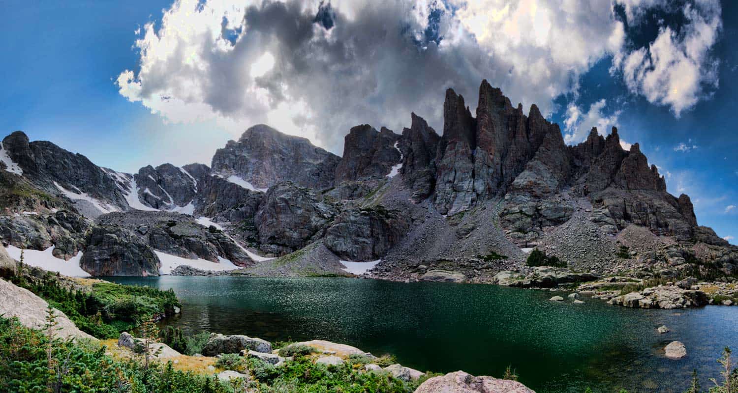
Sky Pond in Rocky Mountain National Park
Situated above Timberline Falls in Rocky Mountain National Park are two spectacular lakes. The highest of the two is Sky Pond, and the lower is called The Lake of Glass. This demanding hike begins at the Glacier Gorge trailhead and takes you past at least three waterfalls and a beautiful set of cascades. Rewards await those who hike all the way up to Sky Pond. Explore our Sky Pond trail profile below for trail details, driving directions, maps, and more.
Note: Rocky Mountain National Park now requires timed entry permits from May 27th through October 10th. See the RMNP permits page for more information.
Trail Snapshot: Sky Pond Hike in Rocky Mountain National Park
| Hike Distance | 9+ miles Round Trip |
|---|---|
| Difficulty | Difficult |
| Duration | Approx 5 hr+ Round Trip |
| Trail Type | Out and Back |
| Starting Elevation | 9240' at Trailhead |
| Elevation Gain | Approx +1647′ |
| Seasons | May-September |
| Dogs | Prohibited in RMNP |
| Hike Trail Map | Click for a Map of Sky Pond in Rocky Mountain National Park |
| Denver Drive Time | 2 hr |
| Driving Directions to Glacier Gorge Trailhead | Click for Google Map |
| Town Nearest Hike | Estes Park, Colorado |
| Beauty | Lakes, wildflowers, waterfall, wildlife: elk, deer, birds |
| Activities | Hiking, fishing, photography |
| Fee | Park Pass Required |
Sky Pond Directions & Trailhead Information
The trail up to Sky Pond begins at either the Glacier Gorge Trailhead (see driving directions above), or at the Bear Lake Trailhead (driving directions). Because the Glacier Gorge Trailhead has a much smaller lot, you may need to drive further up to Bear Lake. There you'll find a short connector trail that will put you on the path down and over to the Glacier Gorge Trail system. In the event that parking at Bear Lake is full, you'll then need to park at the Park & Ride near the Bierstadt Trailhead and take the bus into the trailhead. This service runs 7am to 7PM and more information on the RMNP shuttle bus routes can be found at this link.
Hike to Sky Pond and Lake of Glass
The first destination that you can't and don't want to miss is at .8 miles, Alberta Falls. The trail then climbs toward an eventual trail junction. The way to the Sky Pond is to follow the Glacier Gorge/Loch Vale trail that bears right and ascends for about another .5 mile to the next trail junction. At this second junction, the middle of the three trails leads onto the Loch Vale Trail, and up to the Loch, Timberline Falls, and eventually beyond to Sky Pond. Pictured Above: Creek between the Loch and Timberline Falls.
At Timberline Falls, the trail up to Lake of Glass and Sky Pond is a steep scramble to the right-side of the waterfall. Be aware, the rock may be slick and this area is very steep. Hikers should have good footwear, and may need to be patient for those who are descending this section of the trail. In most of this segment, there is only room for one hiker at a time to safely negotiate the scramble. Many hikers will find the descent of this short portion of the trail more difficult than the way up.
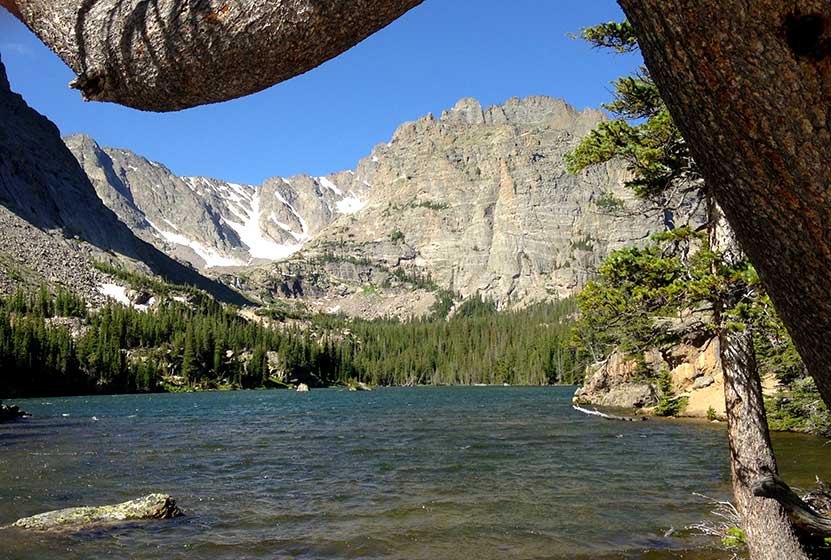
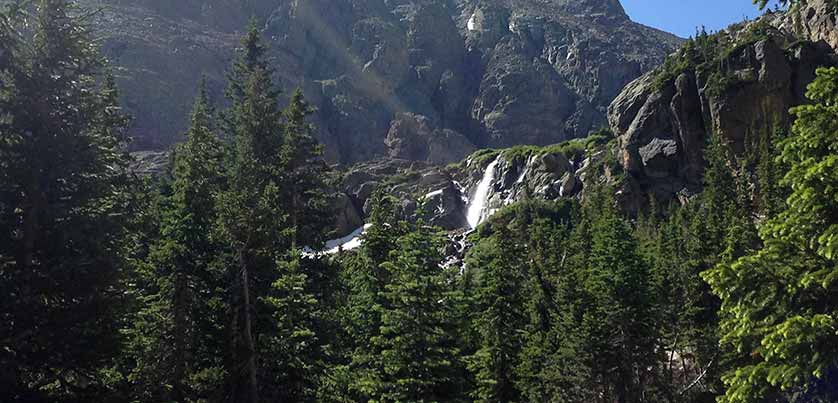
The first lake, Lake of Glass, is only about a quarter-mile beyond Timberline Falls. Many stop here thinking that it's Sky Pond--but it's not. From this vantage point, it's hard to imagine that there is more. However, approximately another quarter-mile will lead to Sky Pond, which is twice the size of Lake of Glass. There is a waterfall hidden just below the Lake of Glass. See our trail profile for this waterfall for details. Pictured below: The Sharks Tooth at Sky Pond.
Sky Pond is surrounded by fields of columbines and other wildflowers. A small shelf waterfall spills out of Sky Pond (pictured below), and a marsh between the two lakes is the home to a beautiful collection of marsh marigolds. From the southwestern shores of Sky Pond, there are incredible views of Petit Grepon, the Sabre, and Sharkstooth--three prominent peaks that surround this high mountain lake.
List and Links of Destinations Along the Loch Vale Trail
1. Alberta Falls - @ .8
2. The Loch - @ 2.7 miles
3. Timberline Falls - @ 4 miles
4. Lake of Glass & Waterfall -@ 4.2 miles
5. Sky Pond - @ 4.6 miles
Tips & Resources for Trail to Sky Pond & Lake of Glass in RMNP :
- You Might Miss it: Lots of people stop at Lake of Glass and think they have made it to Sky Pond. It's not much further, but it is hidden because of the elevation difference.
- Get There Early: There are two important reasons to begin your hikes early in the morning in Rocky Mountain National 1)The trail head parking lots fill up early, and 2) in the Summer months, thunderstorms will form in the early afternoon.
- Trail Map for Bear Lake Corridor: Trail Map Link
- Recommended Map for Rocky Mountain National Park: The trail maps provided by Rocky Mountain National Park are usually sufficient. However, if you plan to hike RMNP often, we recommend purchasing a National Geographic Trails Illustrated Map.
- Colorado Road Conditions: Colorado Road Conditions
- Photo: We would like to express our gratitude to Steven Bratman for sharing such an amazing photograph of this hike.
- After the Hike: Inkwell Brew Coffee
Weather
Map & Driving Directions
Click for Driving Directions

The Loch in Rocky Mountain National Park
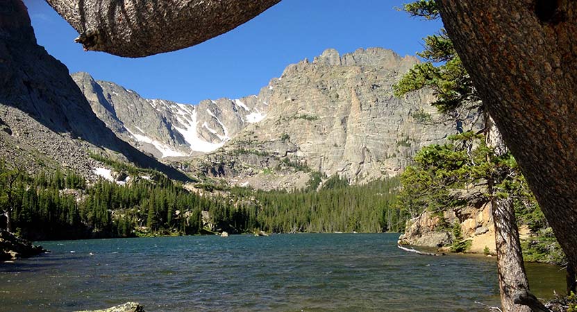
If lakes are your favorite destination, then the hike to The Loch should be added to your trail list in Rocky Mountain National Park. It is a moderately difficult hike on the eastern side of the park where you can hike along the edge of the lake, fish for trout, or come early in the morning to photograph the iconic scenery in Loch Vale. Explore the full trail profile below for driving directions to the trailhead, trail map, and other destinations that can be added to the hike.
The Loch is the Gaelic name given to this lake, the major destination along the Loch Vale trail and the source of Icy Brook, the stream that spills from its eastern edge. Because of it's beauty and the wide variety of vantage points for outstanding scenery, the Loch is popular with photographers. We've found it to be a perfect hike to a tranquil spot to take in the views and enjoy a picnic lunch.
Note: Rocky Mountain National Park now requires timed entry permits from May 27th through October 10th. See the RMNP permits page for more information.
Trail Snapshot: The Loch in Rocky Mountain National Park
| Hike Distance | 5.5+ mile Round Trip |
|---|---|
| Difficulty | Moderate |
| Duration | Approx 3 hr Round Trip |
| Trail Type | Out and Back |
| Starting Elevation | 9240' at Trailhead |
| Elevation Gain | Approx +1000′ |
| Seasons | June-September |
| Dogs | Prohibited in RMNP |
| Hike Trail Map | Click for a Map of The Loch |
| Denver Drive Time | 2 hr |
| Driving Directions to Glacier Gorge Trailhead | Click for Google Map |
| Town Nearest Hike | Estes Park, Colorado |
| Beauty | Lake, wildflowers, waterfall, wildlife: elk, deer, birds |
| Activities | Hiking, fishing, photograph |
| Fee | Park Pass Required |
Parking & Trailhead Information
The trail to the Loch, and the destinations beyond, begins at either the Glacier Gorge Trailhead (see driving directions above), or at the Bear Lake Trailhead (driving directions). Because the Glacier Gorge Trailhead has a much smaller lot, you may need to drive further up to Bear Lake. There you'll find a short connector trail that will put you on the path down and over to the Glacier Gorge Trail system. In the event that parking at Bear Lake is full, you'll then need to park at the Park & Ride near the Bierstadt Trailhead and take the bus into the trailhead. This service runs 7am to 7PM and more information on the RMNP shuttle bus routes can be found at this link.
The Hike to The Loch
The first destination that you can't and don't want to miss is at .8 miles, Alberta Falls (photo above). The trail then climbs toward an eventual trail junction. The way to the Loch is to follow the Glacier Gorge/Loch Vale trail that bears right and ascends for about another .5 mile to another trail junction. At this second junction the trail to the left will take hikers to Glacier Gorge, and the trail to the right takes hikers on a jaunt to Lake Haiyaha. The middle trail leads onto the Loch Vale Trail, and up to the Loch.
Pictured Above: The Loch as seen from the heights near Timberline Falls. Take care to stay the trail as you explore the Loch. It's a heavily visited area with equally heavy impact. The Loch hosts a variety of trout: brookies, cutbows, cuthroats, and rainbows. Mayflies and Caddis flies are common hatches, and black or chernobyl ants can be a particularly good terrestrial pattern to use at the Loch. The wind can kick up along the lake, especially as the rises and warms the rock walls that surround the lake. Some areas on the southern side provide calmer waters. Photographers will find morning sunrises the best time to photograph the amazing landscape of the lake and mountains.
List and Links of Destinations Along the Loch Vale Trail
1. Alberta Falls - @ .8
2. The Loch - @ 2.7 miles
3. Timberline Falls - @ 4 miles
4. Lake of Glass -@ 4.2 miles
5. Sky Pond - @ 4.6 miles
Tips & Resources for Hiking to the Loch in RMNP:
- Hike Further: Be sure to hike and additional approx 1.25 mile (one-way) to Timberline Falls to see one of the most beautiful waterfalls in Rocky Mountain National Park.
- Get There Early: There are two important reasons to begin your hikes early in the morning in Rocky Mountain National 1)The trail head parking lots fill up early, and 2) in the Summer months, thunderstorms will form in the early afternoon.
- Parking: If the parking lot is full at Glacier Gorge Trailhead, there is a shuttle available to take you to the trailhead. This service runs 7am to 7PM and more information on the RMNP shuttle bus routes can be found at this link.
- Trail Map for Bear Lake Corridor: Trail Map Link
- Recommended Map for Rocky Mountain National Park: The trail maps provided by Rocky Mountain National Park are usually sufficient. However, if you plan to hike RMNP often, we recommend purchasing a National Geographic Trails Illustrated Map.
- Colorado Road Conditions: Colorado Road Conditions
- After the Hike: Inkwell Brew Coffee
Weather
Map & Driving Directions
Click for Driving Directions
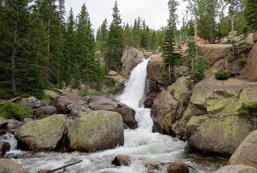
Timberline Falls in Rocky Mountain National Park
Timberline Falls is a demanding 8-mile round-trip waterfall hike in Rocky Mountain National Park. The trail takes you past Alberta Falls up into beautiful Loch Vale. Beyond Timberline Falls hikers will find Lake of Glass, additional falls, and breathtaking Sky Pond.
Glacier Gorge is the home to some of the best hiking in Rocky Mountain National Park, and this waterfall hike is one of the best. Be sure to read through the trailhead and parking information below, because, in the busy season, parking fills up fast. Explore our Timberline Falls trail profile below for trail details, driving directions, maps, and more.
Note: Rocky Mountain National Park now requires timed entry permits from May 27th through October 10th. See the RMNP permits page for more information.
| Hike Distance | 8 miles Round Trip |
|---|---|
| Difficulty | Difficult |
| Duration | Approx 5 hr |
| Trail Type | Out and Back |
| Starting Elevation | 9240′ |
| Elevation Gain | +1510′ |
| Seasons | May-September |
| Dogs | Dogs Prohibited |
| Hike Trail Map | Click for a Map of Timberline Falls |
| Denver Drive Time | 2 hr |
| Driving Directions | Click for Google Map |
| Town Nearest Hike | Estes Park, Colorado |
| Beauty | Waterfall, wildlife: elk, deer, marmots; meadows, lakes, streams |
| Activities | Hiking, photography |
| Fee | Park Pass Required |
Parking & Trailhead Information
The trail up to Timberline Falls begins at either the Glacier Gorge Trailhead (see driving directions above), or at the Bear Lake Trailhead (driving directions). Because the Glacier Gorge Trailhead has a much smaller lot, you may need to drive further up to Bear Lake. There you'll find a short connector trail that will put you on the path down and over to the Glacier Gorge Trail system. In the event that parking at Bear Lake is full, you'll then need to park at the Park & Ride near the Bierstadt Trailhead and take the bus into the trailhead. This service runs 7am to 7PM and more information on the RMNP shuttle bus routes can be found at this link.
The Hike to Timberline Falls
The hike up into the Glacier Gorge/Loch Vale trail system takes you past one of Rocky Mountain National Parks' most accessible waterfalls, Alberta Falls.
After the waterfall, the trail begins to wind up a series of switchbacks for just shy of a mile until a trail junction with the NorthLong's Peak Trail. The trail into Glacier Gorge/Loch Vale then bears right and ascends for about another .5 mile to another trail junction. The trail to the left will take hikers to Glacier Gorge, and the trail to the right takes hikers on a jaunt to Lake Haiyaha (fun to say three times fast) but this trip to Timberline Falls takes the middle trail onto the Loch Vale Trail.
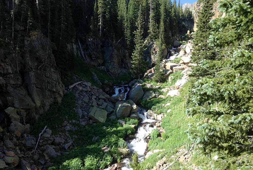
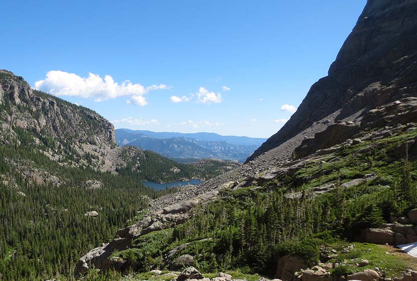
The path follows the path of Icy Brook through a series of longer switchbacks. The brook can be heard gushing and pouring over the rocks below, and one particular switchback there is a great view of its waters casacading through a green canyon (pictured above). At approximately 1 mile after leaving the junction, the trail opens up to more level ground at The Loch. In the distance, beyond the Loch in the west, the cliff face of the Cathedral Wall calls technical climbers to its challenging routes.
The trail continues along the right side of the Loch until another trail junction beyond its western shores and deep in the the lush forest surrounding Icy Brook. The trail up to Timberline Falls, Lake of Glass, and Sky Pond is on the left, and the path to the right will take hikers into the Andrew's Creek area, one of my favorite areas of the Park. Here the trail up to Timberline Falls gets more steep, working its way up through subalpine forest of fir and spruce, the ground bejeweled with Columbine flowers. Soon you'll gain views of the falls in the distance.
A series of stone stairs takes you to the base of the waterfall. In the late Spring and Early Summer, the falls cut through the winter snowpack and creates fantastic shapes out of the snow. For hikers who want to see more, a very steep and slick trail can be found to far right side of the waterfall. This leads up to the Lake of Glass, it's own waterfall, and to Sky Pond.
Video of Timberline Falls in RMNP
Tips & Resources for Hiking Timberline Falls :
- More to Explore: Be sure to budget extra time to explore the lakes above Timberline Falls.
- Parking: If the parking lot is full at Glacier Gorge Trailhead, there is a shuttle available to take you to the trailhead. See details at the the top of this trailprofile
- Gear: Wear good boots with soles that are good for grabbing the rock if you plan to scramble up the steep trail to Lake of Glass and Sky Pond.
- Pack a Lunch: This is a long hike and you'll certainly need water, but you'll also most likely need fuel for the journey back. Download our hiking guide for a list of great hiking food and snacks.
- Trail Map for Bear Lake Corridor: Trail Map Link
- Packing List: Always pack the 10 Essentials. Download our Hiking Guide to get list and dayhiking packing checklist.
- Colorado Road Conditions: Colorado Road Conditions
- After the Hike: Inkwell & Brew Coffee
Weather
Map & Driving Directions
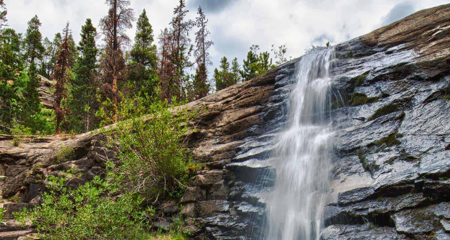
Bridal Veil Falls Hike at Rocky Mountain National Park
Atwenty foot waterfall hidden away in the northern reaches of Rocky Mountain National Park, Bridal Veil Falls makes for a great destination hike. Keep your eyes out for Elk in the meadows along this hiking trail in Colorado's favorite National Park. Get the hike information you need with our hiking snapshot for Bridal Veil Falls, and get more details by exploring the details and tips below.
Note: Rocky Mountain National Park now requires timed entry permits from May 27th through October 10th. See the RMNP permits page for more information.
Trail Snapshot: Bridal Veil Falls in Rocky Mountain National Park
| Hike Distance | 6.6 miles Round Trip |
|---|---|
| Difficulty | Moderate |
| Duration | Approx 4 hr Round Trip |
| Trail Type | Out and Back |
| Seasons | Year Round |
| Dogs | Not Allowed in Park |
| RMNP Map Link | Click Here |
| Denver Drive Time | 1 hr 45 min |
| Directions | Click for Google Map |
| Town Nearest Hike | Estes Park, Colorado |
| Beauty | Waterfall, Meadows, Forest, Creek, Wildlife: Elk, Deer, Birds |
| Activities | Horseback Riding, Hiking Trails |
| Fee | Park Pass Required |
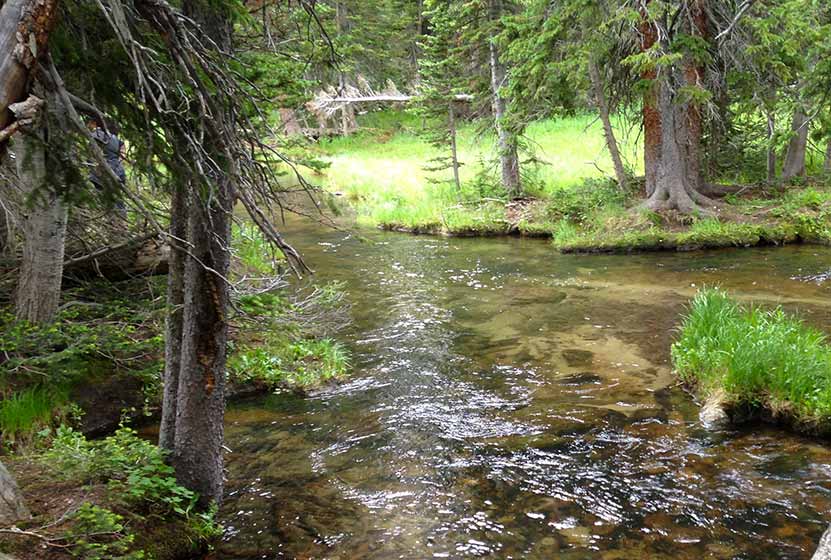
Bridal Veil Falls is a gem tucked away in the northern reaches of Rocky Mountain National Park. This hike is about 1hr 45 minutes from the Denver area and features expansive meadows, wildflowers, forest, and a little bit of a rock scramble. Bridal Veil Falls launches from a rock slab at a diagonal, making it a beautiful site. Most visitors to the National Park go to the center of the park, so you may find yourself alone on the trail on a weekday. I wouldn't expect that on the weekend though.
Like most areas in the park, the wildlife is abundant. We often joke, calling it the zoo. Elk and deer, as well as eagles and other raptors can be seen along Cow Creek trail. The trail to Bridal Veil Falls begins at the Cow Creek Trailhead. You'll pass through meadows and see the cascades along Cow Creek. Eventually, you'll hike up in the forest, getting a bit of a break from the sun. Before the waterfall, you'll encounter some rocks to hike and scramble over, making this a more moderate hike.
Thanks to Catherine Kunst for the photos on this profile. You can read Catherine's trip report at her site here. and to John Kalla for his photo of the falls at the top of this post.
Tips & Resources for Hiking Bridal Veil Falls:
- A Great View: Cross the stream then work your way up the area just left of the falls to the stream above. It's beautiful above the falls, just take care not to turn it into a rock climb. Remember that Water + Rock = Slippery.
- Parking is a Limited: It's just a small area along the road near the ranch. You'll need to parallel park. Also, get their early for a space.
- Not Much Shade: Bring the sunscreen. You'll be in the sun a lot along Cow Creek Trail.
- RMNP Park Map: Trail Map Link
- Colorado Road Conditions: Colorado Road Conditions
- After the Hike: After the Hike: Poppy's Pizza
Weather
Map & Driving Directions
Click for Driving Directions
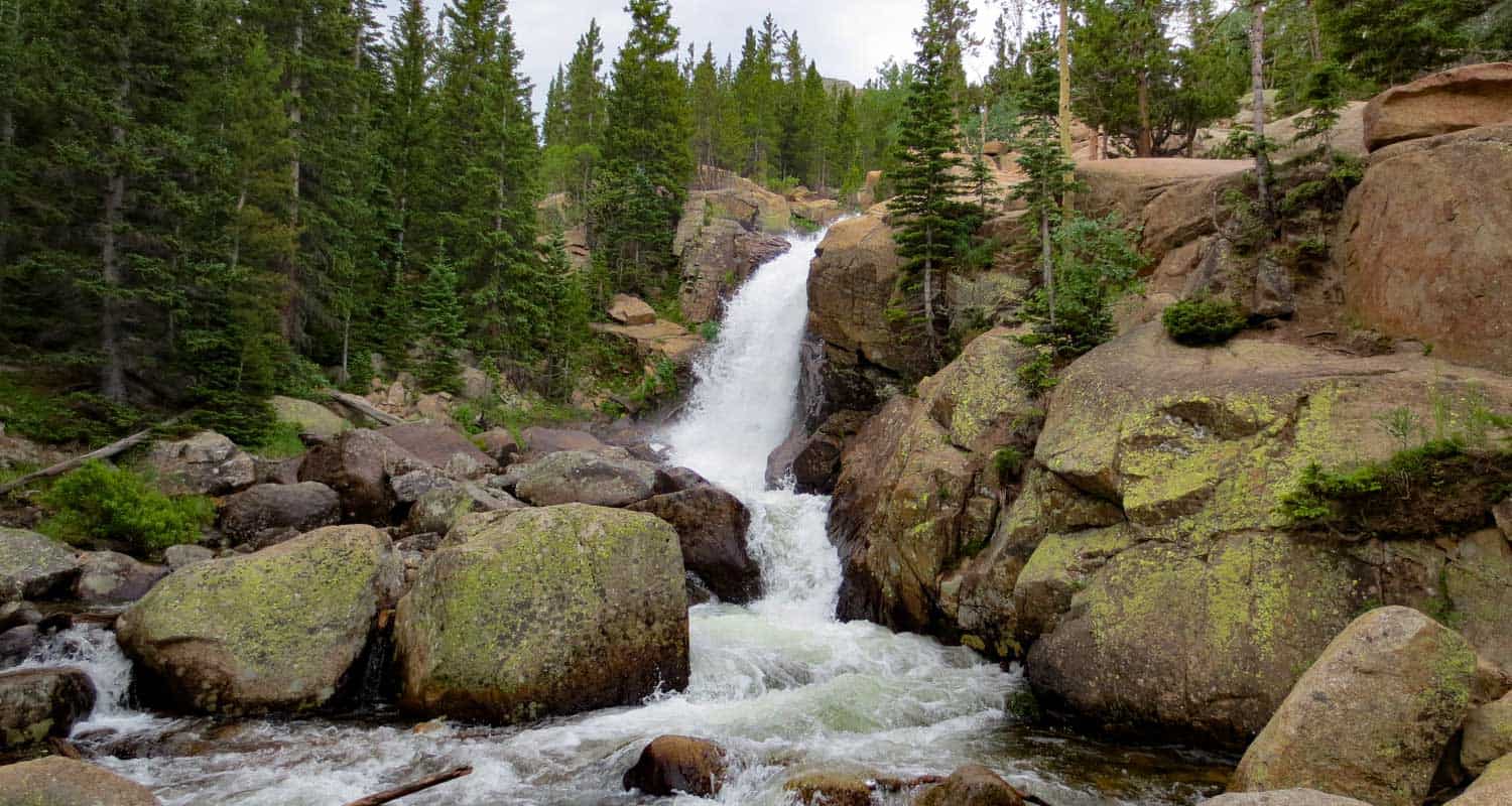
Alberta Falls Hike at Rocky Mountain National Park
Colorado's Rocky Mountain National Park is full of waterfalls and this hike takes you to one of the most accessible waterfalls in the park. Alberta Falls is one of the most popular, short destination hikes in the park, and for good reason. If you only have time for one short hike on the East Side of RMNP, this is a great choice. To get to Alberta Falls, park at the Bear Lake Trailhead (see google directions below), then follow the signs south for Glacier Gorge and Alberta Falls. The waterfall is .8 miles down the trail from the parking area, make this a 1.6 mile out-and-back hike. Start early and hike the full 2.8 miles of trail in to stunning Mills lake inside Glacier Gorge.
Note: Rocky Mountain National Park now requires timed entry permits from May 27th through October 10th. See the RMNP permits page for more information.
| Hike Distance | 1.6 miles Round Trip |
|---|---|
| Difficulty | Medium |
| Duration | Approx 1 hr |
| Trail Type | Out and Back |
| Seasons | Spring thru Fall |
| Dogs | Prohibited in the Park |
| Hike Trail Map | Click Here for a Trail Map |
| Denver Drive Time | 2 hrs |
| Driving Directions to Alberta Falls, Colorado | Click for Google Map |
| Town Nearest Hike | Estes Park, Colorado |
| Beauty | Sub-Alpine Lake, Mountain Views, Wildlife: Abert's Squirrel, Elk, Bear |
| Activities | Picnicking, Hiking Trails, Snowshoeing |
| Fee | Park Pass Required |
Tips & Resources for Hiking to Alberta Falls
- Visitors and Vacationers: Alberta Falls is a great place to take visiting family and friends because it's not too difficult, and you have a lot of options if you want to explore the park
- Bring a Lunch: Getting this far into the park, even just driving, is quite a trip from the outside world. We suggest packing a lunch so that you can stay longer. And food just tastes better outside anyway.
- Trail Map for Bear Lake Corridor: Trail Map
- Rocky Mountain National Park Maps: Maps Link
- Colorado Road Conditions: Colorado Road Conditions
- After the Hike: Poppy's Pizza
 Looking for more waterfalls near Denver? Explore our more than 50 Colorado Waterfall Hikes, our favorite Waterfall Hikes in Rocky Mountain National Park, or 7 Waterfalls within One Hour of Denver.
Weather
Map & Driving Directions
Click for Driving Directions
Bear Lake Hike at Rocky Mountain National Park
From Bear Lake in Rocky Mountain National Park (just 2 hours from Denver), you can launch out on dozens of hiking adventures, trails that range from less than a mile to full day treks back into Glacier Gorge or Andrews Creek. If you are visiting Colorado and looking for a high variety of trails or just a good place to start your vacation, this is one of the best places in the state. For details on the trail, see the hiking trail profile below, and download the trail map to get an idea of the different hikes that begin at Bear Lake.
Note: Rocky Mountain National Park now requires timed entry permits from May 27th through October 10th. See the RMNP permits page for more information.
Trail Snapshot: Bear Lake in Rocky Mountain National Park
| Hike Distance | 0.6 mile loop |
|---|---|
| Difficulty | Easy |
| Duration | Approx 30 min |
| Trail Type | Loop |
| Starting Elevation | 9475′ |
| Elevation Gain | +20′ |
| Seasons | Year Round |
| Dogs | Dogs Prohibited in RMNP |
| Hike Trail Map | Click for a Trail Map |
| Denver Drive Time | 2 hours |
| Driving Directions to Bear Lake Trailhead | Click for Google Map |
| Town Nearest Hike | Estes Park, Colorado |
| Beauty | Sub-Alpine Lake, Mountain Views, Wildlife: Abert's Squirrel, Elk, Bear |
| Activities | Picnicking, Snowshoeing, Hiking Trails |
| Conditions at Bear Lake Trailhead | Click Here |
| Fee | Park Pass Required |
Bear lake is the epicenter of Rocky Mountain National Park. This means that you can access a ton of trails from here, but it also means a lot of traffic. So, we always recommend getting there early, on weekdays, and to go during the off-season - if you can. The Bear Lake Trail is a short 0.6 mile loop around a beautiful lake with views of the Rocky Mountains. The hike is considered handicap accessible; however, the trail is not paved.
Tips & Resources for Hiking Bear Lake In Rocky Mountain National Park :
- For Disabled Visitors: Check out the Disabled Travelers' Companion Website for great info and pictures on more accessible trails in RMNP
- Check out: See our Handicap Accessible Hikes Page for more hikes as well
- Visiting Family & Friends: This is a great place to take visiting family and friends because it's not too difficult, and you have a lot of options if you want to explore the park
- Bring a Lunch: Getting this far into the park, even just driving, is quite a trip from the outside world. We suggest packing a lunch so that you can stay longer. And food just tastes better outside anyway.
- Trail Map for Rocky Mountain National Park: Trail Map Link
- Colorado Road Conditions: Colorado Road Conditions
- Photo Courtesy of Ben Grey.
- After the Hike: Poppy's Pizza
Weather
Map & Driving Directions
Click for Driving Directions

Emerald Lake Hike Rocky Mountain National Park
Emerald Lake is one of the most accessible hikes in Rocky Mountain National Park. If you are visiting RMNP, and have limited time to visit, the trail to Emerald Lake is an excellent option. You'll pass both Dream Lake and Nymph lake before you end your hike at Emerald Lake and it's stunning views of Hallet Peak. For more information on this hike, explore the trail profile which includes trail map, driving directions, and helpful tips and resources to enjoy this Colorado hike in Rocky Mountain National Park.
Note: Rocky Mountain National Park now requires timed entry permits from May 27th through October 10th. See the RMNP permits page for more information.
Trail Snapshot:Emerald Lake in Rocky Mountain National Park
| Hike Distance | 3.6 Miles Round Trip |
|---|---|
| Difficulty | Easy to Moderate |
| Duration | Approx 2-3hr Round Trip |
| Trail Type | Out and Back |
| Elevation Gain | Approx. +605' |
| Seasons | All Year |
| Dogs | Not Allowed in RMNP |
| Hike Trail Map | Click for a Trail Map |
| Denver Drive Time | 1 hr 45 min |
| Directions | Click for Google Map |
| Town Nearest Hike | Estes Park, Colorado |
| Beauty | Lakes, Cascade Waterfalls, Wildlife: Abert's Squirrel, Birds, Bears, Elk |
| Activities | Hiking, Snowshoeing, Fishing |
| Fee | Park Pass Required |
A Colorado Hike with a lot of bang for the buck. What we mean is that there is a lot to see on this 1.8 miles stretch of trail. Starting at Bear Lake, you'll take in a total of four Colorado lakes, and pass a small waterfall near the top of the trail. If you are looking for a handicap accessible hike, the trail around Bear Lake Loop hike may be the most beautiful, handicap accessible trail in Colorado. In the winter, the hike up to Emerald makes for a perfect snowshoe hike.
At Nymph Lake on the way up to Emerald Lake
Emerald Lake Trail Directions & Trailhead Information
The trail to Emerald Lake begins at the Bear Lake Trailhead (driving directions). In the event that parking at Bear Lake is full, you'll then need to park at the Park & Ride near the Bierstadt Trailhead and take the bus into the trailhead. This service runs 7am to 7PM and more information on the RMNP shuttle bus routes can be found at this link. The trail to Emerald Lake is located on your way to Bear Lake, off to the left, just before reaching the shore viewing area of Bear Lake.
For conditions at Emerald Lake, see the Rocky Mountain National Park Trail Conditions page.
List and Links of Destinations From Bear Lake to Emerald Lake
Tips & Resources for Hiking to Emerald Lake :
- Get to the Bear Lake trailhead early: We say this for almost every hike near Denver, but the Bear Lake Parking area is probably the busiest in the park. If you can't get there early, just take the shuttle from the lower parking area.
- The Wildlife: We have seen a beautiful black bear in this area on one occasion. It just saw us and ambled away. As with any hike where there are a lot of wildlife, keep small children within sight at all times. On your way out, be sure to stop around Moraine Park and watch the Elk.
- Snowshoeing to Emerald Lake In the winter, this is a Colorado wonderland and a very accessible trail to snowshoe. You can rent snowshoes for a great price at The Colorado Mountain Shop in Estes Park.
- PhotoS: We would like to express our gratitude to Tim Lumley and Daniel for sharing their photos of Emerald Lake in RMNP.
- Trail Map for Bear Lake Corridor: Trail Map Link
- Colorado Road Conditions: Colorado Road Conditions
- After the Hike: Kind Coffee
Weather
Map & Driving Directions