If you are up for a demanding hike in Rocky Mountain national Park, with 3 waterfalls in the space of less than 5 miles, then the hike up to Lake of Glass Falls is a great choice.
A hidden waterfall that you won’t find on the map! Lake of Glass falls is a segmented cascade spilling into the creek that soon becomes Timberline Falls. This relatively demanding hike in Rocky Mountain National Park begins at the Glacier Gorge trailhead, and takes you past two larger waterfalls on your 4.2 mile journey to Lake of Glass Falls.
Note: Rocky Mountain National Park now requires timed entry permits from May 27th through October 10th. See the RMNP permits page for more information.
Trail Snapshot: Lake of Glass Falls in Rocky Mountain National Park
| Hike Distance | 8.4 miles Round Trip |
|---|---|
| Difficulty | Difficult |
| Duration | Approx 5hr+ Round Trip |
| Trail Type | Out and Back |
| Starting Elevation | 9240′ at Trailhead |
| Elevation Gain | +1600′ |
| Seasons | May-September |
| Dogs | Prohibited in RMNP |
| Hike Trail Map | Click for a Map of Lake of Glass |
| Denver Drive Time | 2 hr |
| Driving Directions to Glacier Gorge Trailhead | Click for Google Map |
| Town Nearest Hike | Estes Park, Colorado |
| Beauty | Waterfalls, lakes, breathtaking views, wildlife: elk, deer, birds |
| Activities | Hiking, fishing, photography |
| Fee | Park Pass Required |
Parking & Trailhead Information
The trail up to Lake of Glass Falls begins at either the Glacier Gorge Trailhead (see driving directions above), or at the Bear Lake Trailhead (driving directions). Because the Glacier Gorge Trailhead has a much smaller lot, you may need to drive further up to Bear Lake. There you’ll find a short connector trail that will put you on the path down and over to the Glacier Gorge Trail system. In the event that parking at Bear Lake is full, you’ll then need to park at the Park & Ride near the Bierstadt Trailhead and take the bus into the trailhead. This service runs 7am to 7PM and more information on the RMNP shuttle bus routes can be found at this link.
The Hike to Lake of Glass Falls
The first destination that you can’t and don’t want to miss is at .8 miles, Alberta Falls. The trail then climbs toward an eventual trail junction. The way to the Lake of Glass Falls is to follow the Glacier Gorge/Loch Vale trail that bears right and ascends for about another .5 mile to a second trail junction. At this second junction, the middle of the three trails leads onto the Loch Vale Trail, and up to the Loch, Timberline Falls (pictured below), then to Lake of Glass Falls, and eventually beyond to Sky Pond.
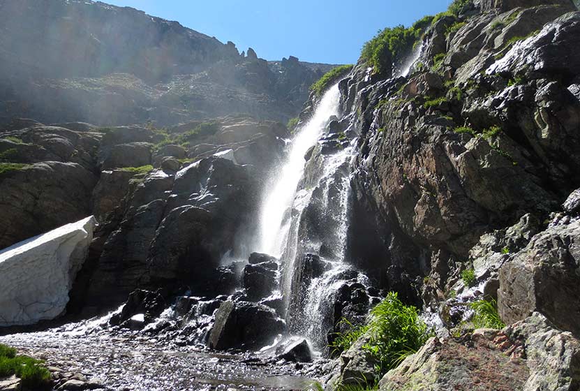
At Timberline Falls (pictured above), the trail up to Lake of Glass Falls is a steep scramble to the right-side of the waterfall. Be aware, the rock may be slick and this area is very steep. Hikers should have good footwear, and may need to be patient for those who are descending this section of the trail. In most of this segment, there is only room for one hiker at a time to safely negotiate the scramble. Many hikers will find the descent of this short portion of the trail more difficult than the way up.
Lake of Glass Falls can be seen trailside, on your left, after the “timberline scramble” and just before reaching Lake of Glass in Rocky Mountain National Park.
List and Links of Destinations Along the Loch Vale Trail
1. Alberta Falls – @ .8
2. The Loch – @ 2.7 miles
3. Timberline Falls – @ 4 miles
4. Lake of Glass & Waterfall -@ 4.2 miles
5. Sky Pond – @ 4.6 miles

Tips & Resources for Hiking to Lake of Glass Falls RMNP :
- Stay the Trail: This area of the park gets a lot of traffic and the waterfall does not have an established trail to it. Because of this, please enjoy the falls from the trail so that we can all reduce the impact on the beautiful, but fragile ecosystem in the high country. Hike on durable surfaces.
- Get There Early: The trailheads fill up early and there are afternoon thunderstorms up at this elevation (and lower elevations in RMNP), so it’s always a good idea to begin your hikes early.
- Another Hidden Waterfall There is another small fan cascade that flows out of Sky Pond. Explore our Sky Pond Trail Profile for more information.
- Trail Map for Bear Lake Corridor: Trail Map Link
- Recommended Map for Rocky Mountain National Park: The trail maps provided by Rocky Mountain National Park are usually sufficient. However, if you plan to hike RMNP often, we recommend purchasing a National Geographic Trails Illustrated Map.
- Colorado Road Conditions: Colorado Road Conditions
- After the Hike: Inkwell Brew Coffee
Weather
Map & Driving Directions
Click for Driving Directions


