Hiking Mt. Galbraith near Golden, Colorado will spoil you with it’s views into two canyons and into the City of Golden. Mount Galbraith is about 25 minutes from downtown Denver, so it makes for a quick escape from the bustle of life in town to take in the fresh air of the foothills. This Colorado hiking trail is a moderate loop great for avid hikers but still accessible for beginners. Explore the full Mt. Galbraith Loop hike profile below for trail map, driving directions, and more tips and details to help you enjoy this adventure near Golden.
Trail Snapshot: Mt. Galbraith Loop Trail Near Golden
| Hike Distance | 4.9 miles |
|---|---|
| Difficulty | Moderate |
| Duration | Approx 2 hr |
| Trail Type | Lollipop |
| Elevation Gain | Approx +1100′ |
| Seasons | Spring, Summer and Fall |
| Dogs | Allowed on Leash |
| Hike Trail Map | Click for a Map of Mount Galbraith Park |
| Denver Drive Time | 26 min |
| Driving Directions to Mt. Galbraith Trailhead | Click for Google Map |
| Town Nearest Hike | Golden, Colorado |
| Beauty | cliff-nesting golden eagle, views into Golden, big horn sheep |
| Activities | Hiking, picnics, mountain biking |
| Video | Click For a Video of Mt. Galbraith Loop |
TMt. Galbraith Loop Hike via the Cedar Gulch Trail
The Mt. Galbraith hike profiled here is a lollipop loop, and the out-and-back section of the Cedar Gulch trail starts in Cedar gulch along a stream. I hiked this in the early morning when the sounds of hummingbirds could be heard all along the stream bed. It makes for a perfect sunrise hike.
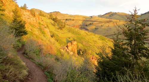
After crossing the stream, it’s a steady, moderate climb with views into Golden Gate Canyon. In the Spring and early Summer, wildflowers will be blooming trailside.
The Cedar Gulch trail runs for 1.3 miles skirting the side of Mt. Galbraith until it hits the intersection with the loop. At this point, you can choose to take the Mt. Galbraith loop trail to the left (clockwise), or to the right (counter-clockwise). We recommend taking the clockwise (left) route which will make for a nice shaded downhill hike off the mountain.
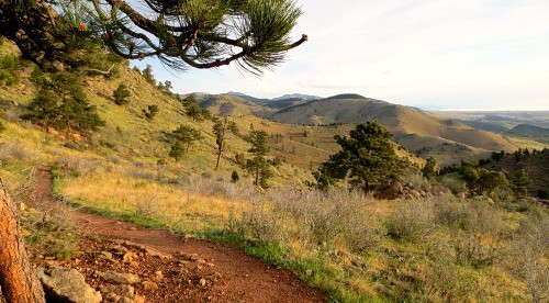
Before you hike to the backside of Mt. Galbraith, you’ll get some great views into Golden, Colorado with the Coors Brewery dominating the landscape below, and views to the southwest of Clear Creek Canyon. The video below gives a short panorama from the overlook where you can look down into Golden.
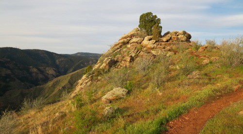
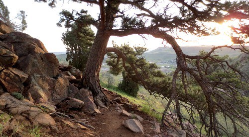
As you continue on the Mt. Galbraith, the trail will take you west until you encounter a rock outcrop (pictured below). I scrambled up to the top and got some great views of the sides of Mt. Galbraith and far down into Clear Creek Canyon. If you are hoping to see wildlife, this is where I’d recommend stopping for a while and breaking out the binoculars.
The back side of Mt. Galbraith provides a bit of shade under ponderosa pines. You’ll enter a burn area, and that’s when the rest of the hikes shifts to going gradually downhill. As the trail enters the canyon again the pines will transition to spruce and fir, and the trail will become more rocky. I talked with a volunteer ranger and he mentioned that this section can be a bit harrowing when it’s covered with snow and ice, but on the May morning I hiked it, only small patches of snow were left.
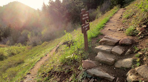
Soon, you’ll emerge from the canyon and be back on the hillside. You’ll see the familiar trail intersection where you’ll want to take a sharp left onto the Cedar Gulch trail which will take you back down Mt. Galbraith to the trailhead.

Tips & Resources for Hiking the Mt. Galbraith Loop Near Golden
- Packing List: Always pack the 10 Essentials. Download our Hiking Guide to get list and dayhiking packing checklist.
- TIP: The Mt. Galbraith trailhead is on the south side of the road. Be aware as you pull out and back onto Golden Gate Canyon Road, as it’s difficult to see cars coming around the bend.
- TIP: If you’re taking your dog to hike Mt. Galbraith with you, it’s a good idea to bring extra water because there is only one stream at the entrance of the trail and no where else for them to drink. However, after a rain, near the rock outcrop, you should be able to find water pooled the rock alongside the trail.
- TIP: Bring the sunscreen. Although there are a lot of trees on the western and northern sections of the loop, most of the trail is exposed to the sun.
- Keep and Eye Out for Rattlesnakes: Like many of the trails in the foothills and along the Front Range, hikers should keep their eyes out for Rattlesnakes as they will often sun themselves to keep warm on the path or along the path.
- TIP: Take it easy at the beginning of the trail. Hiking Mt. Galbraith is most challenging at the start and the rest of the trail is more peaceful and relaxing after that initial incline.
- Trail Map for Mount Galbraith Park: Trail Map Link
- Colorado Road Conditions: Colorado Road Conditions
- After the Hike: Big Daddy Bagels
Weather
Map & Driving Directions to Mt. Galbraith Trailhead
Click for Driving Directions


Just hiked this beauty last weekend. It was great!
Last Saturday was foggy which made this a great hike through the clouds. Moderate incline along side of mountain to start hike, which didn’t make my wife to happy, however, the terrain eases up (turn left and take the loop counterclockwise). My favorite hike so far!
https://www.google.com/amp/denver.cbslocal.com/2017/10/07/rattlesnake-bite-mount-galbraith/amp/
Watch out for rattle snakes.
Good trail. Good views.
Trail is thin. Hard to walk side by side.
Nice trail good view, wildflowers growing next to the trail
Trail is sparse. Walking side by side is difficult.