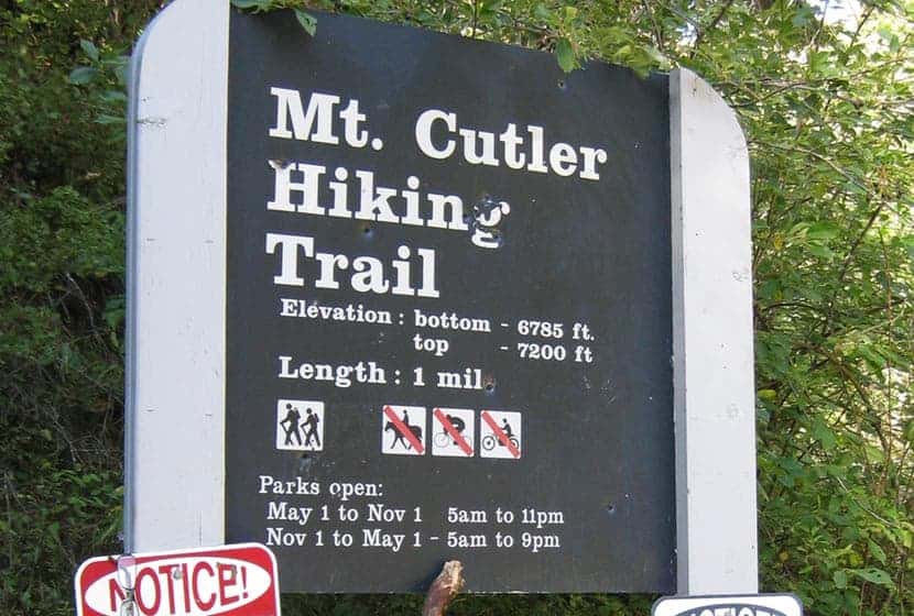
Mt. Cutler in Colorado Springs is an easy, 1-mile hike to the summit of a foothill peak that overlooks Seven Falls, the canyon system of Cheyenne Canyon, and offers panoramic views that make this hike a great option for visiting friends and family. Because it’s just 2 miles out-and-back with less than 500 feet of elevation gain, this hike offers a lot of reward with less effort. Explore the full Mt. Cutler hike profile below for trail map, driving directions, and more tips and details to help you enjoy this adventure in Colorado Springs.
Trail Snapshot: Mt. Culter
| Hike Distance | 2 miles Round Trip |
|---|---|
| Difficulty | Easy |
| Duration | Approx 1 to 2 Hours |
| Trail Type | Out-and-Back |
| Starting Elevation | 6785′ |
| Elevation Gain | Approx +415′ |
| Seasons | Year Round |
| Dogs | Allowed On Leash |
| Hike Trail Map | Click for Trail Map of Mt. Culter in Cheyenne Canyon |
| Denver Drive Time | 1hr 30min |
| Driving Directions to Mt. Cutler Trailhead | Click for Google Map |
| Town Nearest Hike | Colorado Springs, Colorado |
| Beauty | Peak-Top Views, View down into Seven Falls, Rock Formations |
| Activities | Hiking |
Parking & Trailhead Information for Mt. Cutler
From Denver, take Interstate 25 South to Colorado Springs. Exit onto Tejon St. via Exit 140 then take a right onto S. Tejon St. Stay in the right hand lane so that you can turn right onto Cheyenne Boulevard. Follow Cheyenne Blvd. for about 2.5 miles. Here road will fork as it enters Cheyenne Canyon. Take the road to the right that leads into North Cheyenne Canyon. Proceed for about 1.5 miles until you see the Mt. Culter Trailhead roadside parking area on your left. There are no ameneties at the trailhead. The lot will fill fast on the weekends. If it is full, there are other hike options in North Cheyenne Canyon if you continue up the road to Helen Hunt Falls and to the Seven Bridges Hike that also offers a view of a small waterfall, Undine Falls.
The Hike: Mount Cutler in Cheyenne Canyon
The Mt. Culter trail begins at the blue trailhead sign as a broad path ascends on a gentle grade under the shade of pine trees. The trail passes through some deadfall, evenutally opening out to a more level area where red rock formations have been pushed up into what might otherwise be a dull landscape. Like the Royal Arch in the Flatirons and the formations in Red Rocks Canyon in Colorado Springs, these orange and red granite fins are part of a formation that begins 14,000 feet under the surface and runs almost the entire length of Coloroado.
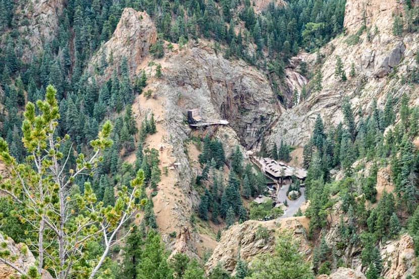
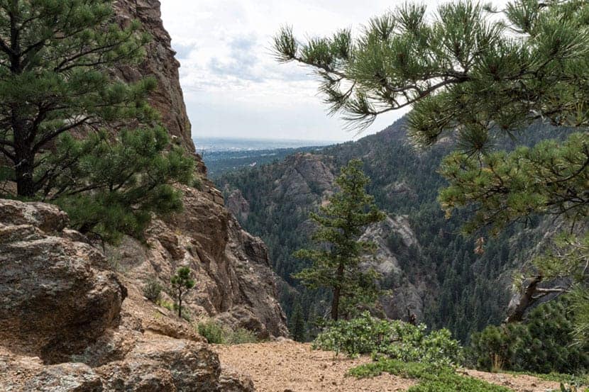
At approximately 0.8 mile, the views open up to the south, where you can look down into Seven Falls. In the Spring and after a good rain, the distant waterfall is quite stunning. To get a close up tour of the falls, you’ll need to make a reservation. See our full trail profile on Seven Falls for more details.
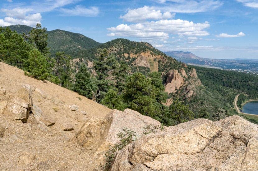
The last segment of the hike to the summit of Mt. Cutler offers great views to the south and the north. At the Summit of Mt. Cutler, look to the North to take in the foothills and views down into the canyon, and to the Southeast you’ll gain views out to the great plains of Colorado. Return via the same trail you hiked to the summit.

Tips & Resources for Hiking Mt. Cutler
- Visit the Starsmore Visitor Center: On your way in or out of the trailhead, stop by the Starsmore Visitor Center to pick up a trail map and view the exhibits.
- TIP: Wear boots or a tennis shoe that has a good sticky tread as there is a lot of loose gravel on this trail up Mt. Cutler
- Trail Map: Cheyenne Canyon and Mt. Cutler Trial Map
- Packing List: Always pack the 10 Essentials. Download our Hiking Guide to get the list and dayhiking packing checklist.
- Colorado Road Conditions: Colorado Road Conditions
- Photo: We would like to express our gratitude to Fritz MB and Phillip Stewartfor sharing such an amazing photographs of Mt. Cutler.
- After the Hike: Bristol Brewing Company


