Catamount Falls Hike Near Colorado Springs
The hike to Catamount Falls is a moderate 2.8-mile loop hike about 25 minutes outside of Colorado Springs. This waterfall hike takes hikers to three different waterfalls and over two different creeks that spill down from the heights of Pikes Peak. It makes for a great weekend adventure, coupled with a great opportunity for brunch at the Pantry in Green Mountain Falls. Explore the full Catamount Falls hike profile below for driving directions, trail route description, and more tips and details to help you enjoy this adventure near Colorado Springs.
NOTICE: Catamount Trail access is closed from 8/4/21 to 9/1/21. For Details see Trails and Open Space Coalition Website.
Trail Snapshot: Catamount Falls in Colorado Springs
| Hike Distance | 2.8 miles |
|---|---|
| Difficulty | Moderate |
| Duration | Approx 1-2 hr |
| Trail Type | Loop |
| Starting Elevation | 7720' |
| Elevation Gain | Approx. +560' |
| Seasons | April through October |
| Dogs | Allowed On Leash |
| Denver Drive Time | 1 hr 30 min |
| Driving Directions to Ute Pass Avenue-Lake Street Trailhead | Click for Google Map |
| Town Nearest Hike | Green Mountain Falls, Colorado |
| Beauty | Waterfall, creek, mountain views, wildflowers |
| Activities | Hiking, photography |
Parking & Trailhead Information for Catamount Falls
The hike to Catamount Falls starts at Thomas Trailhead in the quaint mountain village of Green Mountain Falls. However, since there is no parking available at the Thomas trailhead, the hike must be started from the Gazebo Lake parking area in town. To get to Gazebo Lake, from interstate 25, take exit 141 and go west on Cimarron Avenue/US 24 for 13.5 miles to the Chipita Park/Green Mountain Falls exit. Following Green Mountain Falls Rd/Ute Pass Avenue for approximately 0.7 miles. Take a left onto Lake Street. Here you will find the parking area that lines the north side of the small lake.
The Hike: Catamount Falls Trail in Colorado Springs
The loop route below requires two segments along the streets of Green Mountain Falls. The first 0.4 mile segment of the hike will takes hikers from Gazebo Lake to the Thomas Trailhead. Beginning at Gazebo Lake, walk the roadside of Ute Pass Avenue that follows the southern edge of Gazebo Lake. Take a right at the first intersection onto Hotel Street. The streets can be a bit confusing in Green Mountain falls, and Hotel Street will soon turn into Park Avenue. Follow Park avenue as it winds up to its intersection with Boulder Street, a dirt (and sometimes muddy) road that terminates at the Thomas Trailhead.
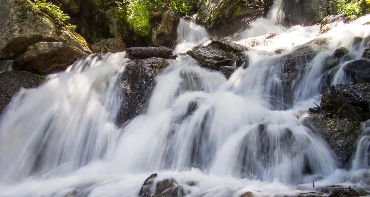
Once on the Thomas Trail, yellow circle blazes mark the way. The initial stretch of trail leads to the base of the first waterfall on this hike, Crystal Falls @ 0.5 mile. This set of cascades is formed by Crystal Creek as it runs down the mountainside from a Crystal Creek Reservoir, one of the lakes situated above Green Mountain Falls on the flanks of Pikes Peak. A bit further up the trail, there is an observation area for taking in the larger leaps of the falls.
The next 0.7 mile segment of the Thomas Trail leads to the second waterfall, Catamount Falls, and is the more demanding portion of the hike. The trail climbs west/northwest until it arrives at Thomas Trail Memorial. After the memorial, Catamount Falls is just a short ways further up the trail. A spur trail leads from the left/south to the site of Catamount falls.
From Catamount Falls, the next segment of trail goes north to take hikers back into Green Mountain Falls. Yellow blazes mark the way across the creek and back to the Thomas Trail. Soon the trail will encounter an intersection with the Catamount trail at the Catamount Trailhead. Staying on the Thomas Trail, it will cross a small footbridge where a third small waterfall can be viewed. The trail then terminates at Belvedere Avenue.
Here, the final 1-mile segment of this loop hike begins. Taking a right onto paved Belvedere Avenue, it will lead east, back into town. Belvedere Avenue will eventually merge with Ute Pass Avenue. Going South/Right on Ute Pass Avenue then leads back to Gazebo Park.
You may be wondering, "What is a 'catamount?'" A catamount is a mountain lion, also known as a cougar. The Catamount Reservoir and Catamount Creek are both named after this creature that lives in the wilds of Colorado.

Looking for more waterfalls near Denver? Explore our more than 50 Colorado Waterfall Hikes, our favorite Waterfall Hikes in Rocky Mountain National Park, or 7 Waterfalls within One Hour of Denver.
Tips & Resources for Hiking to Catamount Falls in Colorado Springs
- Watch for yellow markers: These will guide you along the Thomas Trail.
- Get there early: This can be a crowded hike on the weekends.
- Parking: Out of respect for the residents of Green Mountain Falls, refrain from parking along the roads near the trailhead. Instead, park at Gazebo Lake and follow the trail description above.
- A Shorter Option: For those looking for a less demanding hike to just one waterfall, follow the route above to take in Crystal Falls only. This makes for a less demanding 1 mile, out-and-back hike.
- Packing List: Always pack the 10 Essentials. Download our Hiking Guide to get the list and dayhiking packing checklist.
- Colorado Road Conditions: Colorado Road Conditions
- Photo: We would like to express our gratitude to Ethan Beute for sharing such an amazing photograph of this hike to Catamount Falls in Colorado Springs.
- After the Hike: The Pantry Restaurant: One of our favorite breakfast places in all of Colorado
Weather
Map & Driving Directions
Click for Driving Directions

Helen Hunt Falls in Colorado Springs
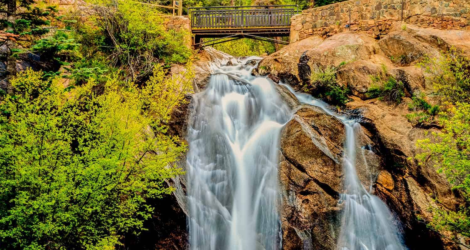
Helen Hunt Falls in Colorado Springs is a 35 foot waterfall requiring only a short walk from the parking area. For a longer and more demanding hike, visitors can take the 4 mile Columbine Trail from the bottom of Cheyenne Canyon to Helen Hunt Falls. This strenuous option affords and experience of the rich ecosystem of this canyon at the base of Pikes Peak. Explore the full Helen Hunt Falls hike profile below for trail map, driving directions, and many of the details you need to enjoy this waterfall in Colorado Springs.
Trail Snapshot: Helen Hunt Falls
| Hike Distance | 1/10 mile or 8 Miles Round Trip |
|---|---|
| Difficulty | Easy to Moderate |
| Duration | Approx 10 min or 4 hrs |
| Trail Type | Out and Back |
| Starting Elevation | 7200′ |
| Elevation Gain | Negligible or Approx 1000'+ |
| Seasons | Year Round |
| Dogs | Allowed On Leash |
| Hike Trail Map | Click for a Map of North Cheyenne Canyon Area |
| Denver Drive Time | 1 hr 45 min |
| Driving Directions to Helen Hunt Falls, Colorado Springs | Click for Google Map |
| Town Nearest Hike | Colorado Springs, Colorado |
| Beauty | Waterfalls, Cheyenne Canyon, North Cheyenne Creek |
| Activities | Hiking, Picnicking, Mountain Biking, Photography |
Parking & Trailhead Information for Helen Hunt Falls
Helen Hunt Falls is located in the upper reaches of North Cheyenne Canyon in Colorado Springs. The driving directions and map in the trail snapshot (above) direct hikers to the small parking area nearest to the waterfall. However, this lot is often full, so visitors will need to drive further up into the canyon to additional parking. The Helen Hunt Falls area is a trailhead to several hikes in the canyon, so the parking areas do fill quickly on weekends and during the busy vacation season. Go early to park close. In case you or a friend are unable to make the short hike to the falls, they are visible along the road from your vehicle. Drive with care through the canyon as there are many cyclists on this stretch of road.
The longer hike begins near the Strasmore Visitor Center at the entrance to Cheyenne Canyon. Click for Driving Directions.
The Hike: Helen Hunt Falls
Helen Hunt Falls is a 35 foot waterfall that cascades over the rock in North Cheyenne Creek. The falls are most beautiful when Cheyenne Canyon's water volume is at it's peak in the late Spring to early Summer, or after a good rain. It's not much of a hike to Helen Hunt Falls because the base of the falls can be accessed just a few steps from the Helen Hunt Falls Visitor Center. The visitor center is open only in the Summer and has snacks and gifts for sale. The waterfall access is open year-round and there is no fee.
In the winter, the frozen falls have a beauty of their own, but be advised that the trails can be very slick and icy.
There is short, but more strenuous trail just after the bridge and to the left. The trail has a set of stairs built into the side of the canyon that lead to an overlook and another perspective on the waterfall.
If you prefer a longer, creekside hike to the Falls, then park at the Strasmore Visitor Center at the entrance to the Canyon. Near the visitor center, you can locate the Lower Columbine Trailhead. This creekside trail weaves through Cheyenne Canyon all the way up to Helen Hunt Falls. It's 4 miles one-way to the Upper Columbine Trailhead near the falls, and about 1000+ feet of elevation gain. Because the trail follows the creek and over a lot of rocky surface, be prepared for slick surfaces, and be sure to wear a solid pair of hiking boots. Trekking poles will be exceptionally helpful on this stretch of trail. About midway up the Columbine Trail, it abandons the creek, crosses the road, and begins a significant climb that includes a set of demanding switchbacks. Eventually, the trail nears Tunnel #2 along Gold Camp Road, then terminates at the Helen Hunt Falls area.
Helen Hunt Falls is named for reformer, activist, and writer, Helen Hunt Jackson, who fought for Native American Rights in the era of Reconstruction after the Civil War.
Tips & Resources for Hiking Helen Hunt Falls
- Explore More: Hike further to Silver Cascade Falls to take in a second waterfall. It's less than 1/2 mile from Helen Hunt Falls with an elevation gain of approximately 250 feet.
- Pack a Picnic Lunch: Helen Hunt Falls and Cheyenne Creek are great places to enjoy a picnic lunch.
- Bear and Mtn Lion Activity: Like many areas along the Front Range of Colorado, Bear and Mtn. Lions live in Cheyenne Canyon and the surrounding countryside. Dispose of food in the proper containers. Be alert. And keep together as a group. It's best that children don't run ahead, but stay with your group. Dogs should be leashed at all times.
- Trail Map for North Cheyenne Canyon: Trail Map Link
- Packing List: Always pack the 10 Essentials. Download our Hiking Guide to get list and dayhiking packing checklist.
- Colorado Road Conditions: Colorado Road Conditions
- After the Hike: Urban Steam Coffee
- Photo: We would like to express our gratitude to Mike Sinko for sharing such an amazing photograph of this hike.
Weather
Map & Driving Directions
Click for Driving Directions
