This waterfall isn’t even on the map, and it’s become my favorite waterfall hike near Denver. In fact, this is the only post that I’m tempted to keep to myself, because not only is there great hiking, but Wellington Lake may be the best camping spot within 90 minutes of Denver.
There is a hitch though: it’s a privately held recreation area and requires a day-use fee of $14 per adult (age 13+) and a fee of $6 fee per child. Fees have gone up so, (depending on the size of your party) it probably makes more sense to pay the camping fee, stay for at least one night, and make the waterfall hike a part of your adventure. Explore the full trail profile below for this beautiful waterfall hike near Denver.
Trail Snapshot: Buffalo Creek Falls at Wellington Lake
| Hike Distance | 0.5 mile RT |
|---|---|
| Difficulty | Easy |
| Duration | approx. 30 minutes |
| Trail Type | Out and Back |
| Elevation Gain | Approx. +500′ |
| Seasons | Year Round |
| Dogs | Allowed On Leash |
| Hike Trail Map | Click for a Map of Buffalo Creek Falls |
| Denver Drive Time | 1 hr 45 min |
| Directions | Click for Google Map |
| Town Nearest Hike | Bailey, Colorado |
| Beauty | Waterfall, Lake, Castle Mountain, Osprey, Waterfowl |
| Activities | Hiking, camping, boating (non-motorized), fishing |
| Fee | 14$ per adult, 6$ per child ages 6-12. See Castle Mountain Rec site for up-to-date fees |
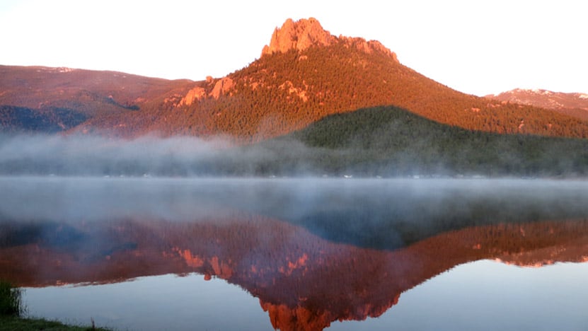
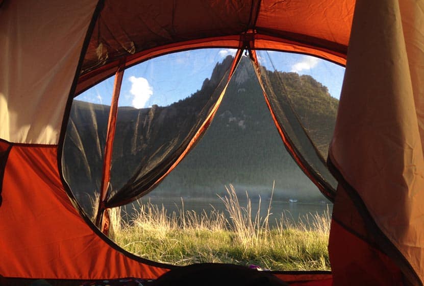
You’ll find Buffalo Creek Falls at the backside of Lake Wellington and just under the shadow of The Castle, a granite mountain that rises off the lake and is named–you guessed it–because it looks like a fortress. Read on to get a detailed set of driving directions, a description of Buffalo Creek Falls, places to explore beyond the falls, and some details on camping at Wellington Lake.
Driving Directions to the Trailhead:
You’ll drive 285 to Bailey, then hang a left onto 68/Wellington Lake Road. 68 is a dirt road and relatively smooth. Still, rain can change things in an instant, so we advise being alert for potholes and washboard. When you arrive at the lake, pull up to the office building, and pay your day-use fee. We have been incredibly impressed by the folks who work here, they are hospitable and kind. If you decide to camp, this is where you pay your campsite fees and get firewood. Put the day-use tag in your car where it’s visible, then take the road around the lake. Be aware of kids running and playing because the road runs right through the campground. The Google maps provided in this post only go about halfway around the lake. You’ll want to continue further, all the way to the scout camp, and that’s where you’ll find the large dirt parking area and the trailhead.
The Hike to Buffalo Creek Falls
My friend Matt and I took our two 4 1/2-year-old daughters with us on this hike and they did great. Look for the trailhead that begins just to the left of the Scout Camp sign. It’s been raining almost every day this year (2015) so there was a lot of mud and puddles at the start. This gives way to a trail that climbs about 400 yards or less up to the base of the falls.
Here, at the bottom of the waterfall, the creek spills itself into a fan of cascades. Look for the trail that runs to your right and goes to a falls overlook bridge. The trail and steps are in need of some repair, but it’s a short jaunt to the top. The waterfall is really unique. It’s a shelf waterfall, but the water, over time, has scalloped out the rock to create ripples. So, when the water is really flowing, such as in early Summer or after a good rain, the waterfall creates a spray of waves. It’s not enormous or breathtaking, but it’s got a really unusual character about it. Watch the video to see what I’m trying to describe with words that an image can better tell. In my opinion, it’s much better than Maxwell Falls, which is probably the most popular waterfall hiking destination near Denver.
But the waterfall isn’t even the best part. The creek above the falls is nothing but cascade after cascade. I scrambled around and explored about 100 yards further up South Buffalo Creek and found some shallow caves and hidden spots with pools and miniatures falls. I’m looking forward to going back to hike the creek as far as I can manage, possibly all the way to the ridgeline. I should make a few of recommendations at this point: 1) hike on durable areas to prevent erosion, 2) it’s an easy place to slip and twist an ankle, so wear good shoes or boots and be mindful, and 3) pick up any trash you see and pack it out with you.
Finally, it’s important to note that this waterfall will likely be a trickle by midsummer. The best time to go will we mid-May through July 1. However, it should also be a great midsummer after a good rain.
Camping at Wellington Lake
There are 75 camping sites at Wellington Lake, including group sites, and many of them right on the shore. You can camp with everything from tents to larger RVs, though it depends on the site you pick. To make sure you will have enough room at a particular site, be sure to give Castle Mountain Rec a call at 303.838.5496 before you book online. We love this place because we can paddleboard, fish, the kids catch minnows and crawdads, and there more hikes beyond the waterfall hike. We even watched an osprey dive into the water and snag a fish from the lake. There are restrooms, water sources, but no showers and no cell service (but that’s why you’re camping).

Tips & Resources for Hiking Buffalo Creek Falls:
- You’ve Got to Camp Here: You can book your campsite online at the Castle Mountain Recreation Reservation Page. This place packs out in the Summer, so make your reservations early. There are also First Come, First Served sites.
- Dogs: If you bring your dog on this hike, be sure to keep them on a leash. If they get out on the rock, it’s slick, and they can tumble into the cascades. We heard a story of a dog getting swept away down the falls. Of course, the same thing can be said for children. Well, you don’t need them on a leash, but keep a close eye on them around the steep and slick terrain around the waterfall.
- Trail Map for Buffalo Creek Falls Trailhead: Trail Map Link
- Colorado Road Conditions: Colorado Road Conditions
- After the Hike: Crow Hill Cafe, Bailey, Colorado
Weather
Map & Driving Directions
Click for Driving Directions


Agreed, these are great falls! Still flowing strong as of 6/27/15, shooting up out of indentations in the rock and fanning out wide. The trail continues from the waterfall up to The Castle overlooking the lake. Climbing gear is probably needed to get all the way to the top, but there are many accessible outcroppings to scramble up for for a nice view.
The falls were still going at a good rate in early August of 2015! A word of warning – while the shelf rock seems harmless, it is still quite slick. We stopped to take a picture there, and one of my girls actually slipped and fell over the falls. She was fine – bruised but not broken – but still a heart-stopping moment.
Falls are great… but seriously, $50 to get into the lake is ridiculous and the road getting there is horrible.
It appears that they have increased their day-use rates. I would agree, that it now makes more sense to camp and make the waterfall a part of your camping trip. Another option that may make the cost (and washboarded road) worthwhile is to do more than the hike when using a day-use permit: kayak or paddleboard, fish, and swim.
Beautiful lake, though the road getting there is the worst I’ve seen in CO. Blew my struts getting there. Come to find out another friend blew hers too. Please fix your road with the large fees you charge.
Prices have changed no car fee, just per person $14 as of 2021 https://www.castlemountainrec.com/day-use-1
Thanks, Judy. I’ve updated the fees on our page to reflect the 2021 updates.