Hall Ranch, just outside of Lyons Colorado, is a hiking, mountain biking, trail running destination that features red sandstone buttes, vast green meadows, and panoramic views of white snowcapped meadows. Tucked into the foothills near the St. Vrain River, the trails at Hall Ranch are a great escape from life in the city. Explore the full Hall Ranch hike profile below for trail map, driving directions, and more tips and details to help you enjoy this adventure in the Boulder County.
Trail Snapshot: Hall Ranch Hike Near Lyons
| Hike Distance | 2 to 9.2 miles Round Trip |
|---|---|
| Difficulty | Easy to Moderate |
| Duration | Approx 5.5 hrs for Loop Hike |
| Trail Type | Out and Back and Loop |
| Starting Elevation | 5500′ |
| Elevation Gain | Approx Total +2479′ on Loop |
| Seasons | Year Round |
| Dogs | Dogs are Prohibited in Hall Ranch |
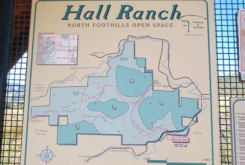
| Hike Trail Map | Click for a Map of Hall Ranch Hiking Trails |
| Denver Drive Time | 1 Hour |
| Driving Directions to Hall Ranch Trailhead | Click for Google Map |
| Town Nearest Hike | Lyons, Colorado |
| Beauty | wildflowers, vistas, grasslands, buttes, pine trees, wildlife |
| Activities | Hiking, photography, picnic tables, mountain biking, trail running |
Directions & Trailhead Information for Hall Ranch Hike
Hall Ranch is situated west of Lyons, Colorado about 16 miles north of Boulder. It’s easy to access via the CO 7. There are two trailheads for Hall Ranch. The primary Hall Ranch Trailhead is located off Saint Vrain Drive/CO 7 West, about a mile outside of Lyons. The parking area is located on the North side of the road. This is the best access for most of the hikes and has both restrooms as well as a picnic shelter that can accommodate up to 24 people. The second smaller trailhead is the Antelope Trailhead, located at the end of Antelope Drive just northwest of Lyons. This second trailhead provides access to the Antelope trail, a connector trail described below.
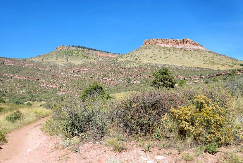
Sandstone Buttes at Hall Ranch
The Hikes: Hall Ranch Hike
There are several options for trails at Hall Ranch:
-
Nighthawk/Bitterbrush Loop – 9.2 Miles RT – +2480′ – Moderat
-
Nelson Loop Trail – 2.2 Mile Loop – +299′ – Moderate
-
Nighthawk Trail at Hall Ranch – 9 Miles RT – +1282′ – Moderate/h3>
-
Bitterbrush Trail – 7.4 RT – +898′ – Moderate
-
Antelope Trail – 1 Mile Trail Connector +458′ – Moderate
-
Button Rock Trail – 2 Mile Trail Connector +220′ – Easy
Probably the most popular is the Nighthawk Trail/Bitterbrush Loop. The loop starts at the west side of the main trailhead and sports a variety of landscapes: expansive meadows, tall buttes, pinion pines, and 180-degree views at its higher elevations. Starting at the main trail, hikers will soon come to an intersection with the Nighthawk trail and Bitterbrush. For this trail profile, we’ll take a clockwise approach, following the Nighthawk trail westward. The Nighthawk trail makes a steady climb to where it tops out at approximately 7700′ where it offers great views out to Longs Peak and a panorama of Rocky Mountain National Park. Here, hikers will notice an intersection with the Button Rock trail. This 2-mile out-and-back trail is not part of the loop. Staying on the Nighthawk Trail, it will meet up with the Nelson Loop Trail. Hikers can choose to go right or left, both trail segments will link up with the Bitterbrush after approximately 1 mile. Now about 5.5 miles into the hike, hikers will follow the Bitterbrush Trail as it descends for 3.7 miles back down to the main trailhead.
The Nelson Loop can only be accessed by first hiking either the Nighthawk or the Bitterbrush to where they connect up with the Nelson Loop. If you would like to do a lollipop loop hike, we recommend taking the Bitterbrush up to the Nelson Loop, hiking the loop, then returning via the Bitterbrush. This makes for a 9.6-mile hike. The Nelson Loop features the remnants of the old Nelson Homestead just off of the southern segment of the loop.
The Nighthawk trail can also be hiked as a 9-mile out-and-back trail. However, we recommend the full loop above because it’s almost the same total distance and offers a greater variety of landscape. The Nighthawk Trail is hiker-only, so it makes for a great option if you prefer to avoid horse and mountain bike traffic. This trail is our favorite, offering vast meadows of green in the Spring and early Summer with views out to Mt Meeker and other snowcapped peaks.
The Bitterbrush Trail is a moderate 3.7 trail that begins at the main trailhead or that can be accessed midway by way of the Antelope Trailhead. Out-and-back, it makes for a 7.4-mile trip.
From the Antelope Trailhead, the 1-mile Antelope Trail takes you west to meet up with the Bitterbrush Trail. Gaining approximately 500′ in a mile, it can make for a great 2-mile out-and-back trail run and provides some unique views not available on the longer trails.
The Button Rock Trail leads down to the Sleepy Lion Trail at Button Rock Preserve where hikers can pick up a whole series of trails around Ralph Price Reservoir.
Tips & Resources for Hiking Hall Ranch Hike Near Boulder
- Stay the Trail: Follow the designated trails. Keep off the old dirt roads.
- Dogs Prohibited: No pets are allowed at Hall Ranch in order to protect wildlife habitat.
- Trail Map: Hall Ranch Trail Map
- Packing List: Always pack the 10 Essentials. Download our Hiking Guide to get the list and dayhiking packing checklist.
- Colorado Road Conditions: Colorado Road Conditions
- After the Hike: The Stone Cup
Weather
Map & Driving Directions
Click for Driving Directions


Horses are allowed on all trails except the button rock extension.