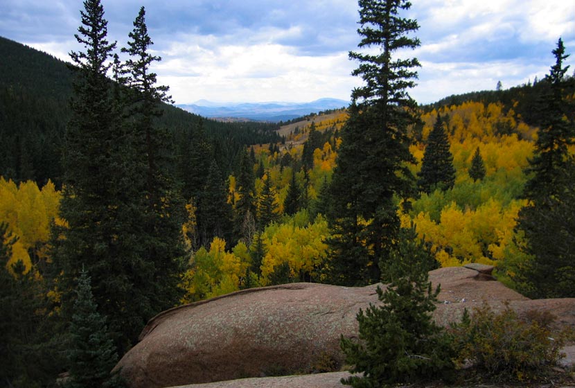
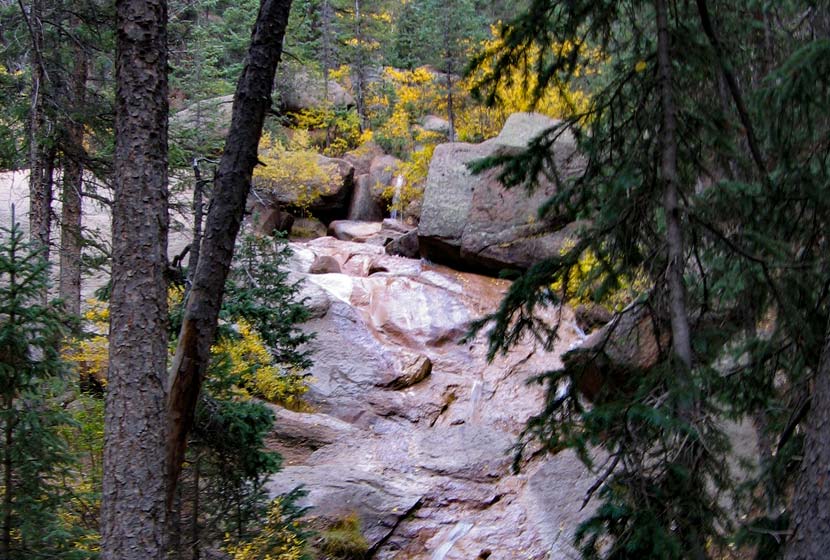
Horsethief Falls is a small slab waterfall located 45 minutes from Colorado Springs on the West side of Pikes Peak. The Horsetheif Falls trail requires a 1.4-mile easy hike (one-way) to the falls. This hike, along with nearby Pancake Rocks make for great fall hiking and a scenic falls drive to see the golden aspens of the Colorado Front Range. The Horsethief Falls Trails joins up with two other trails if you would like to add more time to your adventure and explore the rock formations of this unique area. See the full Horsethief Falls hike profile below for trail map, driving directions, and more tips and details to help you enjoy this adventure near Colorado Springs.
Trail Snapshot: Horsethief Falls Hike
| Hike Distance | 2.8 miles Round Trip |
|---|---|
| Difficulty | Easy |
| Duration | Approx 2 hrs |
| Trail Type | Out and Back |
| Starting Elevation | 580′ |
| Elevation Gain | Approx +750′ |
| Seasons | May to October |
| Dogs | Allowed On Leash |
| Hike Trail Map | Horsethief Falls and Pancake Rocks Trail Map |
| Denver Drive Time | 2 hr |
| Driving Directions to Horsethief Falls Trailhead | Click for Google Map |
| Town Nearest Hike | Cripple Creek, Colorado |
| Beauty | waterfall, creek, pine, beaver ponds, rock formations, fall colors |
| Activities | Hiking, photography, mountain biking, snowshoeing, camping |
Horsethief Falls Trailhead Directions
Horsethief Falls trailhead is located just off of Highway 67 about halfway between Divide and Cripple Creek, Colorado. From Divide, turn south on Highway 67 and drive approximately 9.3 miles until you spot a closed railroad tunnel on the left side of the road. Just past the tunnel the road will bend and the trailhead parking area is on the left side of the road. Zoom in on the driving directions map at the bottom of this post to get a better visual on the parking area.
The Hike: Horsethief Falls Trail
The Horsethief Falls Trail begins on right side of the old tunnel exit, following a wide dirt path steadily uphill before eventually flattening out. The elevation gain for this hike is just a bit over 500′, so we considered grading its difficulty-level as moderate. However, because it’s just 1.4 miles one-way, we kept it in the Easy hikes category.
The trail will cross the shallow creek at about 0.7 mile in. Here, hikers will encounter the first intersection. The Ring the Peak Trail (marked “Horsethief Park Trail” on the map) bears to the left, but the way up to Horsethief Falls is to continue straight on the Horsethief Falls Trail. Crossing the creek again the trail will soon intersect, at about 0.9 mile, with the Pancake Rocks Trail (on the right). Again, continue straight on the Horsetheif Falls trail. In this area, you’ll be able to take in views to the northeast of Sentinel Point. This is an almost perfect area to take in the changing aspens along the forests surrounding Pikes Peak.
The trail will bend to the right (south) and cross over the creek once again and make its way up to the base of Horsethief Falls.
Tips & Resources for Hiking Horsethief Falls Hike
- TIP: To make the trail longer, you may opt to proceed to the Ring the Peak Trail to Putney Gulch via Horsethief Park, or hike up to Pancake Rocks Trail.
- Go Early: Parking is limited and that can be a problem.
- Trail Map: Horsethief Falls Trail Map
- Packing List: Always pack the 10 Essentials. Download our Hiking Guide to get the list and dayhiking packing checklist.
- Colorado Road Conditions: Colorado Road Conditions
- After the Hike: Home Café in Cripple Creek
Weather
Map & Driving Directions
Click for Driving Directions


