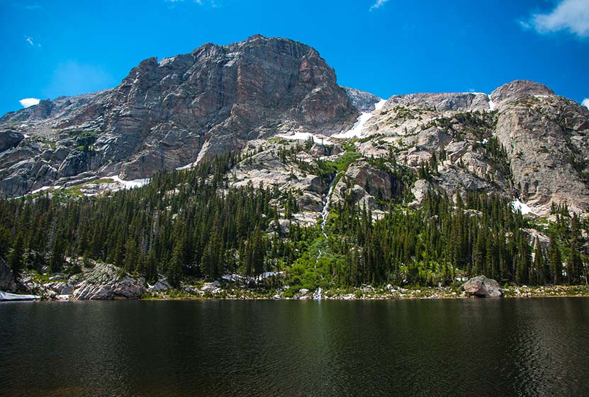
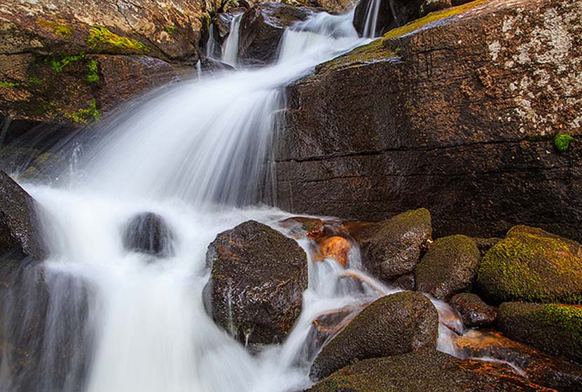
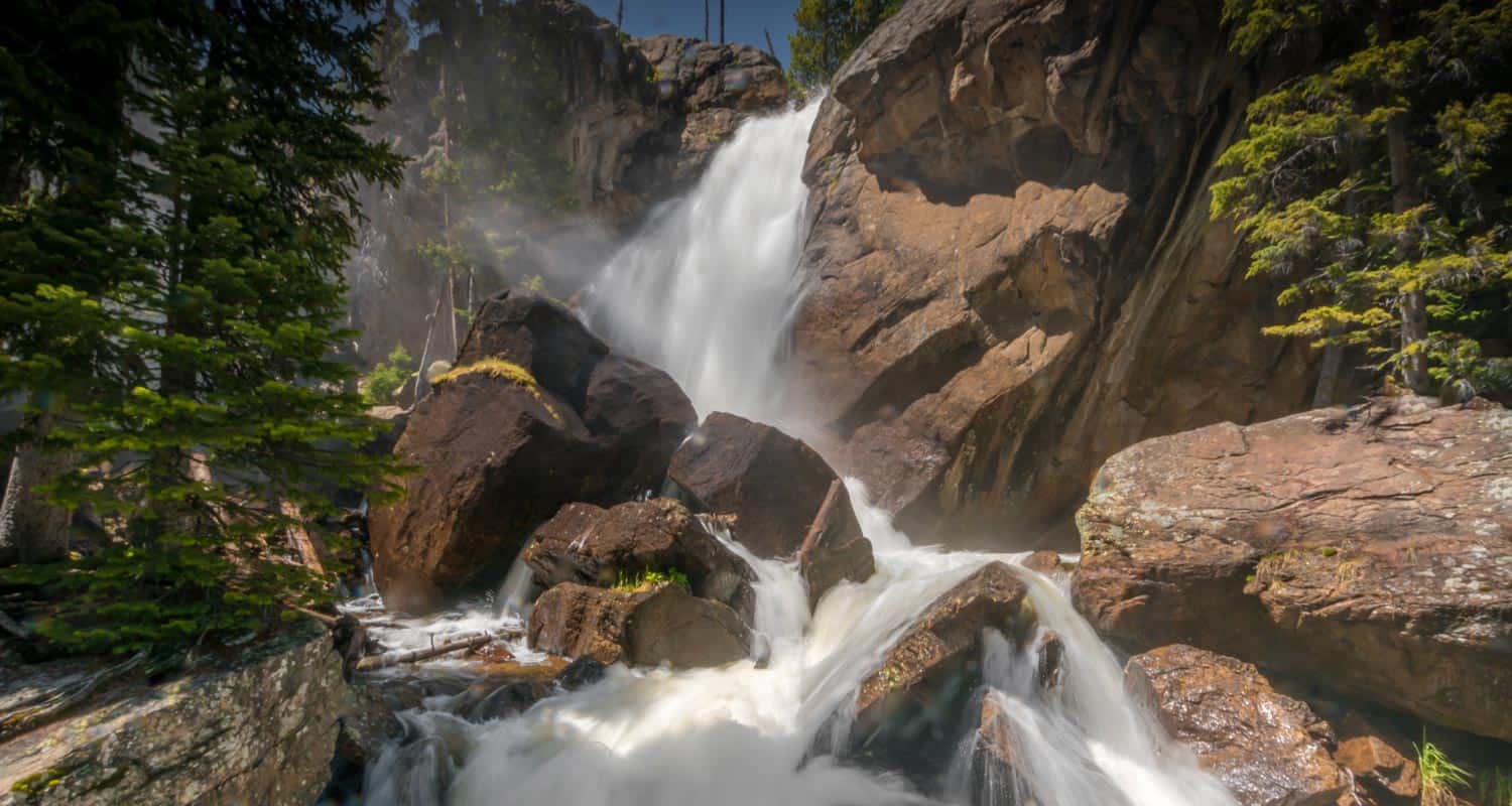
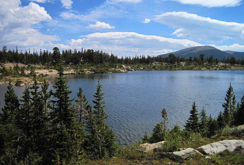
Pear Lake Hike in Rocky Mountain National Park
Pear Lake is a great destination for solitude, fishing, and mountain views. It's a 6.5 mile, demanding hike through some of the best wildflower country in Rocky Mountain National Park. After passing Finch Lake, the trail makes its way to the higher, Pear Lake where Copeland Mountain appears to shoot straight from its shores into the sky. Explore the full Pear Lake hike profile below for trail map, driving directions, and more tips and details to help you enjoy this adventure in Rocky Mountain National Park.
Note: Rocky Mountain National Park now requires timed entry permits from May 27th through October 10th. See the RMNP permits page for more information.
Trail Snapshot: Pear Lake in Rocky Mountain National Park
| Hike Distance | 13 miles Round Trip |
|---|---|
| Difficulty | Difficult |
| Duration | Approx 7-8 hr Round Trip |
| Trail Type | Out and Back |
| Starting Elevation | 8470′ |
| Elevation Gain | Approx +2112′ |
| Seasons | Spring through Fall, Winter Snowshoeing |
| Dogs | Prohibited in RMNP |
| Hike Trail Map | Click for a Map of Pear Lake RMNP |
| Denver Drive Time | 1 hr 30 min |
| Driving Directions to Finch Lake Trailhead | Click for Google Map |
| Town Nearest Hike | Allenspark, Colorado |
| Beauty | Waterfall, mountain views, meadows, aspen, river, wildlife: blue dragonfly, jackrabbit, mallard, Abert’s squirrel, elk, deer, moose, bear; wildflowers |
| Activities | Picnicking, hiking trails, fishing, snowshoeing, horseback riding, backcountry camping (with a permit), photography |
| Fee | Park Pass Required |
Parking & Trailhead Information for Pear Lake
The hike to Pear Lake begins at the the Finch Lake Trailhead, located approximately 1/5th of a mile east of the larger Wild Basin Trailhead near Allenspark, Colorado. Because there is very limited parking at the Finch Lake Trailhead, most hikers will need to park at the Wild Basin Trailhead and add the 1000' feet of trail between the Wild Basin Trailhead and the Finch Lake Trailhead to their journey. There is an alternative approach via the Allenspark Trailhead. However, the route described in this trail profile will be from the Finch Lake Trailhead nearest to the Wild Basin Trailhead.
- Map and Driving Directions to the Finch Lake Trailhead
- Map and Driving Directions to the Wild Basin Trailhead
The Hike: Pear Lake Trail in RMNP
The hike up to Pear Lake is a steady climb through a forest of pine, aspen, spruce, and meadows laden with wildflowers. It's a demanding hike from the outset, coursing up a set of switchbacks to gain the ridge of a lateral moraine. After this initial east bearing segment, the trail turns back to the west begins a gentle descent through one of Rocky Mountain National Park's most stunning displays of wildflowers. Near the bottom of the moraine, near Fox Creek, the trail encounters its first junction. The the trail to the right/west leads towards both Finch and Pear lakes (the left/east trail leads to the Allenspark Trailhead). Climbing higher, the trail will pass an overlook with views of the distant mountain peaks of Pagoda, Meeker, and Chief's Head, as well as views of the greater Wild Basin area.
The next trail junction--at approx. 2.5 miles--has been named "Confusion Junction" because of its power to confound hikers. Pause and study the trail signage in order to choose the correct trail. The correct way is the trail labeled "Pear Lake" and/or "Finch Lake."
After approximately 1/4 mile, the trail passes through a burn area from the 1978 fire, which has made a good recovery and is now riddled with summer wildflowers. Continuing to work uphill, the trail makes several stream crossings before a descent to Finch lake, which begins at 3.8 miles. Then, at approximately 4.25 miles, the trail makes a hard right-turn. This part of the trail is often obscured by snow as late as as midsummer and early as the first signs of autumn.
At Finch Lake the trail wraps around the eastern edge, then the northern shore of the lake. The next segment of trail, from Finch Lake to Pear Lake is approximately 2 miles. These are steep and demanding. Winter snows last into the early months of summer. July brings an incredible display of wildflowers in both the forest and meadows, and the abundance of moisture and vegetation makes this broad valley a great place for viewing wildlife.
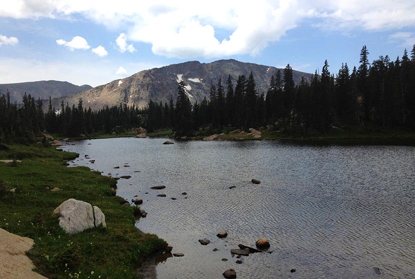
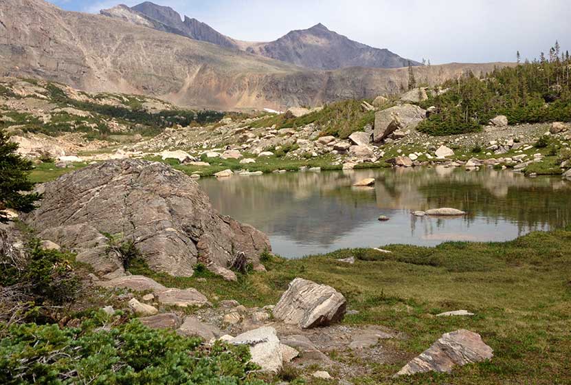
At approximately 6 miles, the trail will cross pear creek. The forest then gives way to rock and eventually to Pear Lake. Pear Lake is enclosed by a ring of rock and mountain. The rugged rock and cliffs of Copeland Mountain come down to meet the northwestern shores. In the early hours of morning, the images Copeland Mountain and Ouzel peak can be seen mirrored in the lake.
Pear Lake is a great place to fish and is catch and release only. A fishing license is required and State and Park fishing regulations apply. There are two campsites near Pear Lake: Pear Creek (just below the lake), and Pear Lake Campsite. These backcountry camping sites can be reserved through the RMNP Backcountry Offices. Because this is such an extensive hike (13 miles roundtrip), camping may be a good option if you want to fish or explore the surrounding area.
Further exploration can be made of the Cony Creek drainage where a series of paternoster lakes lead up to the highest lake, Cony Lake. This area does not have maintained trails and requires hikers to have well-developed backcountry land navigation skills.

Tips & Resources for Hiking to Pear Lake in RMNP
- Packing List: Always pack the 10 Essentials. Download our Hiking Guide to get list and dayhiking packing checklist.
- Fuel Your Body: It's a long and very demanding hike, so be sure to bring plenty of water and food for the trip.
- Get there early: Parking lot might get full even early in the morning.
- You’re in Bear Country: Black Bears live in the Wild Basin area and are active on the months of April through November. Be aware, dispose of your food responsibly, and don’t food or anything else with a strong scent in your vehicle.
- Trekking Poles: For most hikes in RMNP, especially if you are traveling on unmaintained trails, we recommend using Trekking Poles. They take a lot of weight off the knees and help in navigating uneven terrain.
- Trail Map for Wild Basin Area: Trail Map Link
- Colorado Road Conditions: Colorado Road Conditions
- Photo: We would like to express our gratitude to Shea Oliver for sharing such amazing photographs of this hike to Pear Lake in RMNP.
- After the Hike: Rock Creek Tavern & Pizzeria
Weather
Map & Driving Directions
Click for Driving Directions

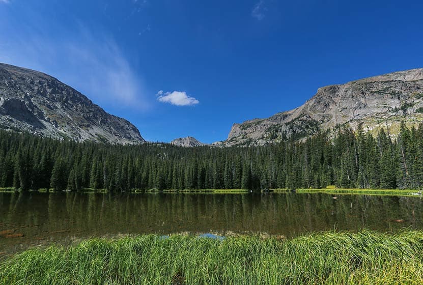
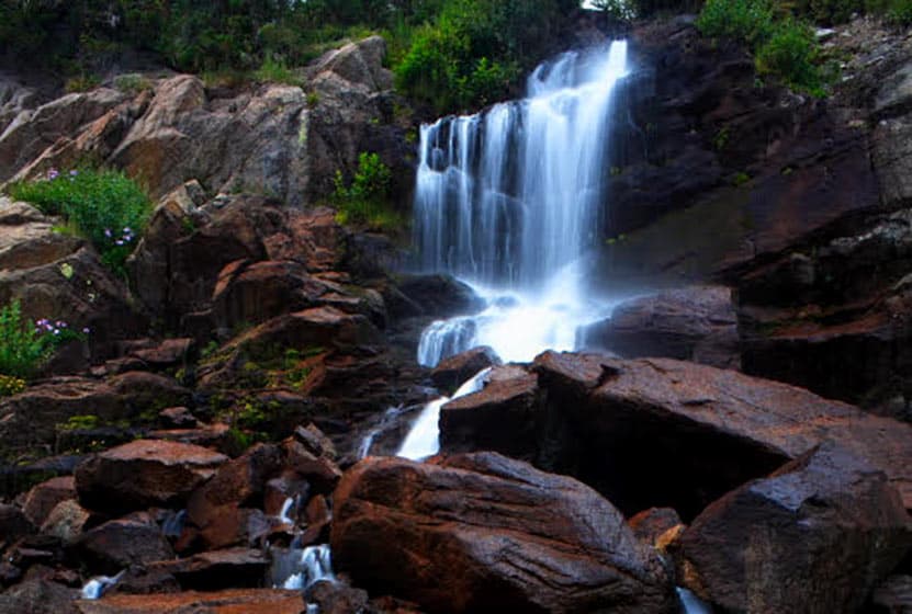
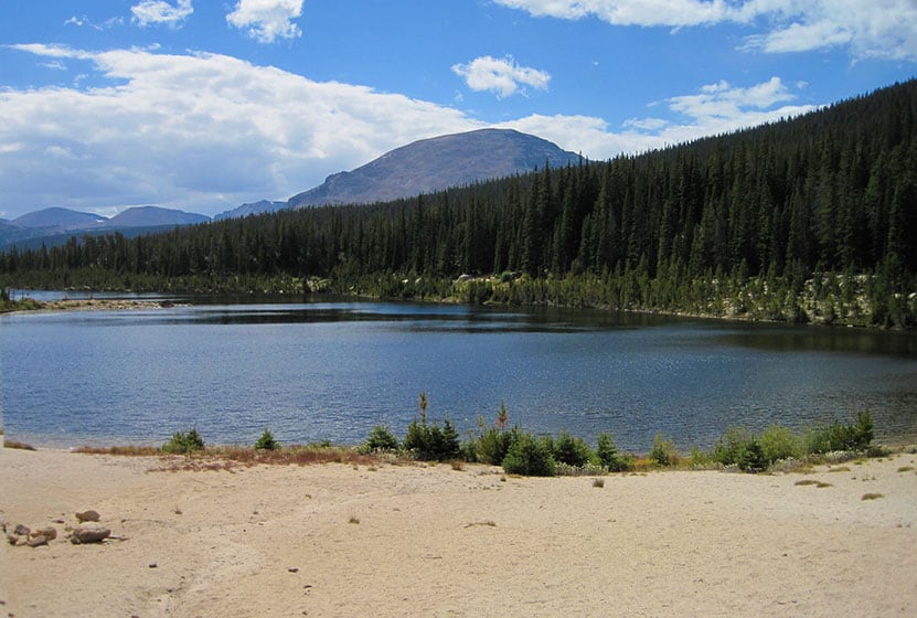
Finch Lake Hike in Rocky Mountain National Park
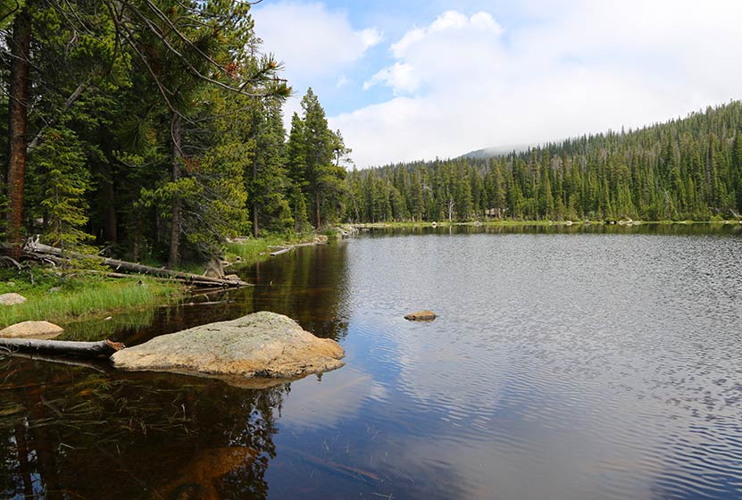
Finch Lake is a 4.5 mile hike through pines, aspen glades, and wildflower laden meadows to a sub-alpine lake where the forest surrounds its shores. The Finch Lake trail is a great choice for those who prefer solitude as it's one of the lesser traveled trails in the Wild Basin region of RMNP. Explore the full Finch Lake hike profile below for trail map, driving directions, and more tips and details to help you enjoy this adventure in Rocky Mountain National Park.
Note: Rocky Mountain National Park now requires timed entry permits from May 27th through October 10th. See the RMNP permits page for more information.
Trail Snapshot: Finch Lake in Rocky Mountain National Park
| Hike Distance | 9 miles Round Trip |
|---|---|
| Difficulty | Moderate |
| Duration | Approx 5-6 hr Round Trip |
| Trail Type | Out and Back |
| Starting Elevation | 8470' |
| Elevation Gain | Approx. +1442' |
| Seasons | Spring through Fall |
| Dogs | Prohibited in RMNP |
| Hike Trail Map | Click for a Map of Finch Lake RMNP |
| Denver Drive Time | 1 hr 30 min |
| Driving Directions to Finch Lake Trailhead | Click for Google Map |
| Town Nearest Hike | Allenspark, Colorado |
| Beauty | Waterfall, mountain views, meadows, aspen, river, wildlife: blue dragonfly, jackrabbit, mallard, Abert’s squirrel, elk, deer, moose, bear; wildflowers |
| Activities | Picnicking, hiking trails, snowshoeing, horseback riding, backcountry camping (with a permit), photography |
| Fee | Park Pass Required |
Parking & Trailhead Information for Finch Lake
The Finch Lake Trailhead is located approximately 1/5th of a mile east of the larger Wild Basin Trailhead near Allenspark, Colorado. Because there is very limited parking at the Finch Lake Trailhead, most hikers will need to park at the Wild Basin Trailhead and add the 1000' feet of trail between the Wild Basin Trailhead and the Finch Lake Trailhead to their journey. There is an alternative approach via the Allenspark Trailhead. However, the route described in this trail profile will be from the Finch Lake Trailhead nearest to the Wild Basin Trailhead.
- Map and Driving Directions to the Finch Lake Trailhead
- Map and Driving Directions to the Wild Basin Trailhead
The Hike: Finch Lake Trail in RMNP
The hike up to the Lake is a steady climb through a forest of pine, aspen, spruce, and meadows laden with wildflowers. It begins with a set of switchbacks then follows the contours of a moraine. After gaining the ridge of the moraine, the trail begins a gentle descent through one of Rocky Mountain National Park's most stunning displays of wildflowers. Near the bottom of the moraine, just above Fox Creek, the trail will come to its first junction. The the trail to the right/west leads towards both the lake (the left/east trail leads to the Allenspark Trailhead). Climbing higher, the trail will pass an overlook with views of the distant mountain peaks and the greater Wild Basin area.
The next trail junction--at approx. 2.5 miles--has been named "Confusion Junction" because of its power to confound hikers. Pause and study the trail signage in order to choose the correct trail. The correct way is the trail labeled "Pear Lake" and/or "Finch Lake."
After approximately 1/4 mile, the trail works its way through a burn area from a 1978 fire, now in full recovery mode and blanketed with summer wildflowers. Continuing to work uphill, the trail makes several stream crossings before a descent to the lake, which begins at 3.8 miles. Then, at approximately 4.25 miles, the trail makes a hard right-turn. This part of the trail is often obscured by snow as late as as midsummer and early as the first signs of autumn.
At the Lake the trail wraps around the eastern edge, then the northern shore of the lake. During midsummer, swarms of bright blue dragonflies dance along its waters. The Finch Lake backcountry camping sites are located on the north and northwestern side. These backcountry camping sites can be reserved through the RMNP Backcountry Offices.
Finch Lake is not a good fishing destination. However, Pear Lake, just 2 miles further up the trail, is a much better destination for anglers and offers spectacular views of the rugged peaks surrounding it.
Finch Lake - Another View
Tips & Resources for Hiking to Finch Lake in RMNP
- Prepare: It's a long and demanding hike, so bring lots of water and high-energy food.
- Packing List: Always pack the 10 Essentials. Download our Hiking Guide to get list and dayhiking packing checklist.
- Get there early: Parking lot might get full even early in the morning. Hikers should expect to have to park at the Wild Basin Trailhead and add approximately 1/2 mile to their round trip hike (1000' one-way to the Finch Lake Trailhead).
- You’re in Bear Country: Black Bears live in the Wild Basin area and are active on the months of April through November. Be aware, dispose of your food responsibly, and don’t food or anything else with a strong scent in your vehicle.
- Trail Map for Wild Basin Area: Trail Map Link
- Colorado Road Conditions: Colorado Road Conditions
- Photo: We would like to express our gratitude to Shea Oliver for sharing such amazing photographs of this hike.
- After the Hike: Rock Creek Tavern & Pizzeria
Weather
Map & Driving Directions
Click for Driving Directions
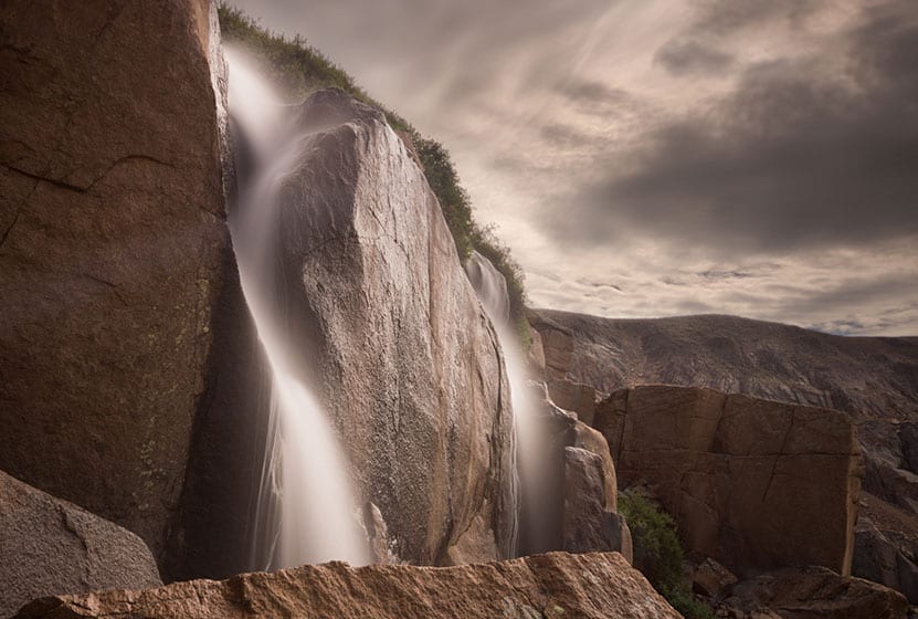
Lyric Falls Hike in Rocky Mountain National Park
Lyric Falls is a beautiful stair-step waterfall that spills over the moss-covered granite slabs of Hunters Creek in Rocky Mountain National Park. A lesser-known waterfall, Lyric Falls requires a 3/4 mile segment on the unmaintained social trail that winds along Hunters Creek. Locating the falls may be a bit challenging and land navigation skills are needed for this hike in the Wild Basin area of RMNP. Explore the full Lyric Falls hike profile below for trail map, driving directions, and more tips and details to help you enjoy this adventure in Rocky Mountain National Park.
Note: Rocky Mountain National Park now requires timed entry permits from May 27th through October 10th. See the RMNP permits page for more information.
| Hike Distance | Approx 8 miles Round Trip |
|---|---|
| Difficulty | Moderate |
| Duration | 6-8 hr Round Trip |
| Trail Type | Out and Back |
| Starting Elevation | 8430' |
| Elevation Gain | Approx. +1730' |
| Seasons | Spring through Fall |
| Dogs | Prohibited in RMNP |
| Hike Trail Map | Click for a Map of Wild Basin Area |
| Trails Illustrated Map | Recommended Topo Map Noting Location of Lyric Falls |
| Denver Drive Time | 1 hr 30 min |
| Driving Directions to Sandbeach Lake Trailhead | Click for Google Map |
| Town Nearest Hike | Allenspark, Colorado |
| Beauty | Mountain views, aspen, ponderosa, limber pine, creek, wildlife: Abert’s squirrel, elk, deer, moose, bear; wildflowers |
| Activities | Picnicking, hiking trails, winter snowshoeing, horseback riding, backcountry camping (with a permit), photography |
| Fee | Park Pass Required |
Parking & Trailhead Information for Lyric Falls
The Sandbeach Lake Trailhead is located off of County Road 84 near, just about 1/2 mile west from its junction with Highway 7. See the driving directions link above for the detailed route. The trailhead is across the street from the Wild Basin Lodge and Event Center. The trailhead has toilet facilities and parking capacity of about 25 cars (includes gravel side-lot).
The Hike: Lyric Falls Trail in RMNP
The first segment of the hike to Lyric Falls follows the Sandbeach Lake Trail for approximately 3.2 miles to the footbridge crossing Hunter's Creek. An indistinct social trail is located near the bridge on the east side of Hunter's creek. This second trail segment is 3/4 of a mile is unmaintained, which means that hikers should have a sufficient level of land navigation skills (map reading and proficiency with a compass/gps unit) to negotiate the terrain to Lyric Falls.
This .75 mile section follows the course of Hunter's Creek Northwest and uphill to the location of Lyric Falls. There is no marker for Lyric Falls, but it can be located on the National Geographic Trails Illustrated Map of Rocky Mountain National Park. Hikers will likely hear several smaller cascades along the way. In the same way, the cascades of Lyric Falls will be heard before seen, and the sounds of its splash and spray will be the best way to locate the falls.
A meadow bright with wildflowers can be found just bit further up Hunter's Creek beyond Lyric Falls.
Campsites Along the Lyric Falls Trail
Stay overnight and explore the larger Hunter's Creek Drainage. There are several Backcountry Camping sites along the Sandbeach Lake Trail: Hole-in-the-Wall, Campers Creek, Beaver Mill, and Sandbeach Lake. These backcountry camping sites can be reserved through the RMNP Backcountry Offices. Staying overnight, hikers can then explore Lyric Falls, Sandbeach Lake, and this lesser hiked area of the Wild Basin in Rocky Mountain National Park.
Tips & Resources for Hiking to Lyric Falls in RMNP
- Packing List: Always pack the 10 Essentials. Download our Hiking Guide to get list and dayhiking packing checklist.
- Recommended Trail Map: We recommend the National Geographic Trails Illustrated Map which indicates the location of the Backcountry Camping Sites, and provides topo information, too.
- Get there early: Parking is limited. Arrive early to secure a parking spot at the trailhead.
- You’re in Bear Country: Black Bears live in the Wild Basin area and are active on the months of April through November. Be aware, dispose of your food responsibly, and don’t food or anything else with a strong scent in your vehicle.
- Colorado Road Conditions: Colorado Road Conditions
- Photo: We would like to express our gratitude to Thomas Mangan for sharing such great photos of this hike to Lyric Falls in RMNP. Tom leads photography tours in Rocky Mountain National Park. Check out his site thomasmagan.com for details.
- After the Hike: Meadow Mountain Cafe in Allenspark, Colorado
Weather
Map & Driving Directions
Click for Driving Directions
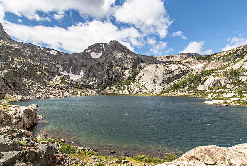
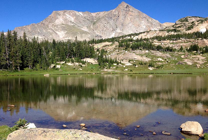
Bluebird Lake in Rocky Mountain National Park
Bluebird Lake is a 6 mile hike to an alpine lake surrounded by craggy peaks in the Wild Basin of Rocky Mountain National Park. Add an additional 1/2 mile spur trail to reach great trout fishing at Ouzel Lake. Hikers will enjoy panoramic views of the Wild Basin and the sites and sounds of several cascade waterfalls along the way. Wildflowers, waterfalls, and lakes await, so explore the full Bluebird Lake hike profile below for trail map, driving directions, and more tips and details to help you enjoy this adventure in Rocky Mountain National Park.
Note: Rocky Mountain National Park now requires timed entry permits from May 27th through October 10th. See the RMNP permits page for more information.
Trail Snapshot: Bluebird Lake in Rocky Mountain National Park
| Hike Distance | 12 miles Round Trip |
|---|---|
| Difficulty | Difficult |
| Duration | Approx 7+ hr Round Trip |
| Trail Type | Out and Back |
| Starting Elevation | 8566' |
| Elevation Gain | Approx. +2478' |
| Seasons | Spring through Fall, Winter Snowshoeing |
| Dogs | Prohibited in RMNP |
| Hike Trail Map | Click for a Trail Map |
| Denver Drive Time | 1 hr 30 min |
| Driving Directions to Wild Basin Trailhead | Click for Google Map |
| Driving Directions to Winter Recreation Parking for Wild Basin Hikes | Click for Google Map |
| Town Nearest Hike | Allenspark, Colorado |
| Beauty | Lake, alpine tundra, waterfall, mountain views, meadows, river, wildlife: Abert's squirrel, elk, deer, moose, marmot, bear; wildflowers |
| Activities | Picnicking, hiking trails, snowshoeing, horseback riding, backcountry camping (with a permit), photography |
| Fee | Park Pass Required |
Parking & Trailhead Information for Bluebird Lake
The southeast corner of Rocky Mountain National Park boasts one of the loveliest portions in the park known as the Wild Basin. The Wild Basin Trailhead is located just 15 minutes outside of Allenspark, Colorado along Highway 115. There is a ranger station at at the Wild Basin Trailhead with toilets and drinking water available.
In the winter (October-May), Hwy 115 may not be plowed to the trailhead, and hikers will need to park their vehicles at a winter parking lot for Wild Basin hikes. Be aware that hikes from the winter parking lot add on another 3 miles of hiking (one-way). There are other small parking areas, like the Finch Lake Trailhead, that may be accessible and allow hikers to park closer to the Wild Basin Trailhead. It's important to know that Hwy 115, though titled a "highway", is a maintained dirt road, which means that it can be used by 2WD vehicles. However, after heavy rains and other severe weather, its quality may degrade until it is repaired. 4WD may be needed when snow is on the ground.
The Hike: Bluebird Lake Trail in RMNP
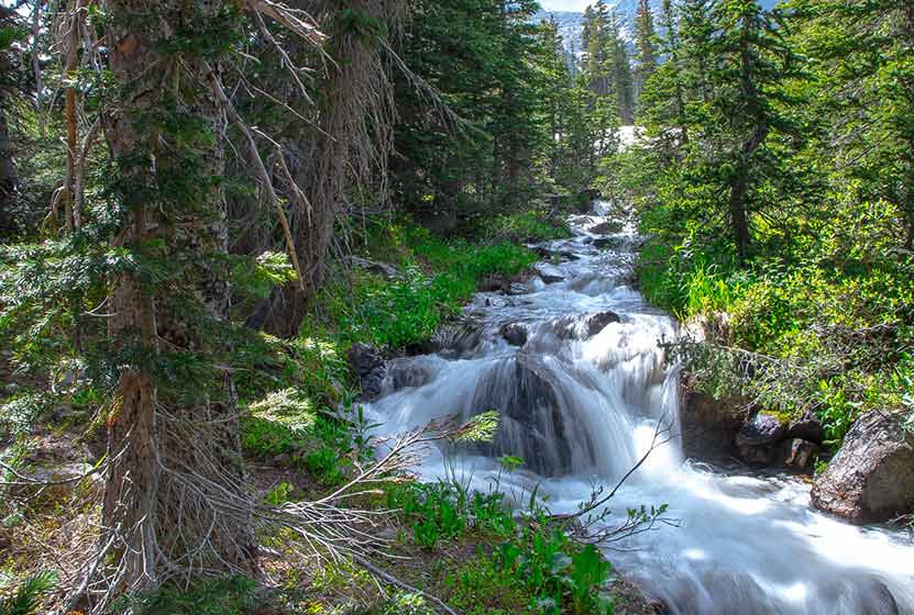
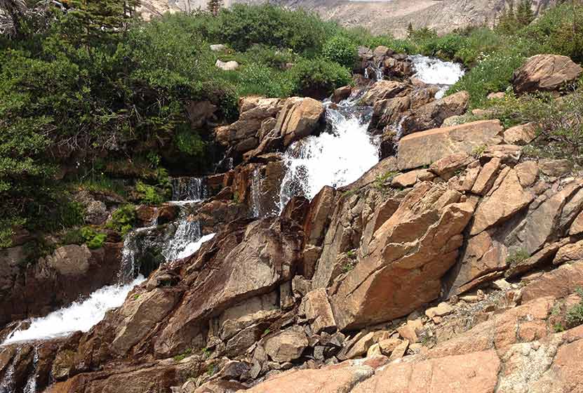
With an elevation gain of over 2400' over 6 miles of trail, the hike up to Bluebird Lake in RMNP is demanding, but not without its rewards. The hike to Bluebird Lake begins at the Wild Basin Trailhead, then winds through the central region of the Wild Basin, passing three cascade waterfalls along the way, and a fourth unnamed waterfall in the meadows above Ouzel Lake.
The first waterfall on this hike is Copeland Falls, found 0.4 mile into the hike on this first, easy segment of trail. For details on accessing both the lower and upper leaps of Copeland Falls, check out our full trail profile for Copeland Falls.
The trail continues west/southwest following North Saint Vrain Creek until it reaches the first important trail junction. The trail to the right leads past a series of backcountry campsites. These are reservable through the Rocky Mountain National Park Wilderness offices and make for a great place to stay for longer adventures into the Wild Basin area. The left-hand trail is the correct way towards the Bluebird Lake trail system and Bluebird Lake.
Having taken the left-hand trail, the path soon crosses North St. Vrain Creek on a log bridge, one that recently was rebuilt to replace the bridge that washed out during the 2013 floods. An unnamed cascade can be viewed from the bridge area. Soon after the bridge, the trail meets with a second trail junction at Calypso Cascades. Taking the right-hand trail, the cascades (named after the purple orchids that grow along the creek) come into view. The path crosses a second bridge at 1.8 miles and begins a challenging climb as the trail weaves through a set of switchbacks up to Ouzel Falls at 2.7 miles.
At 0.4 mile beyond Ouzel Falls, the trail comes to a junction with the Bluebird Lake trail; this is 3.1 miles into the hike, approximately half-way to Bluebird Lake. This new trail begins a steady climb up a ridgeline, through an area burned out by a fire that started from a lightning strike back in 1978. Yet the almost 40 years have brought some change to the landscape. Wildflowers decorate the hillsides, and new trees have come back and begun to establish themselves on the mountainsides.
At 4.5 miles, there is a marked trail spur that leads to Ouzel lake. This 1/2 mile spur takes hikers to some of the best fishing in Rocky Mountain National Park! Of course, a Colorado State fishing license is required. A hike down this spur to Ouzel, will add another 1 to this hike to Bluebird, and it may be a good idea to visit Ouzel on the way back, after judging the conditions of the skies. From the Ouzel Spur junction, Bluebird Lake is just 1.6 miles further, but 1000' in elevation higher, making this part of the hike the most challenging. An unnamed waterfall can be viewed just in the meadows past Chickadee Pond (the small pond just past the trail Ouzel Lake trail spur).
Crossing boulder fields and snow, the trail can be difficult to discern at times, and hikers can keep track of the trail by keeping a look out for cairns (stacked rocks marking the trail). Near the sign for the Upper Ouzel Creek campsite, the trail will cross Ouzel Creek and begin a very steep climb up to Bluebird Lake. Bluebird Lake does not have fish, but it makes up for it with the views, particularly the rugged face of Ouzel Peak in the southwest.
Tips & Resources for Hiking to Bluebird Lake in RMNP
- Too Long of A Hike?: Because this is a 12 mile round-trip hike--13 miles if you add in Ouzel Lake--it may be best to make this hike a part of a larger overnight adventure. Reserve one of the two backcountry camping sites along the Bluebird Trail to spend some time fishing Ouzel Lake and exploring the other destinations along the trail. Contact the RMNP Wilderness Offices to reserve a site.
- Summer Thunderstorms: If you see clouds with dark undersides building in the west, this means that thunderstorms are likely--a typical occurrence on most summer days. Begin hikes early to avoid storms and consider turning back if weather looks threatening.
- Get there early: Parking may be somewhat limited as with many hikes in RMNP area and can get full even early in the morning.
- You're in Bear Country: Black Bears live in the Wild Basin area and are active on the months of April through November. Be aware, and dispose of your food responsibly.
- Trail Map for Wild Basin Area: Trail Map Link
- Packing List: Always pack the 10 Essentials. Download our Hiking Guide to get list and dayhiking packing checklist.
- Colorado Road Conditions: Colorado Road Conditions
- Photo: We would like to express our gratitude to Erik Wolf for sharing such an amazing photograph of this hike to Bluebird Lake in RMNP.
- After the Hike: Meadow Mountain Cafe
Weather
Map & Driving Directions
Click for Driving Directions

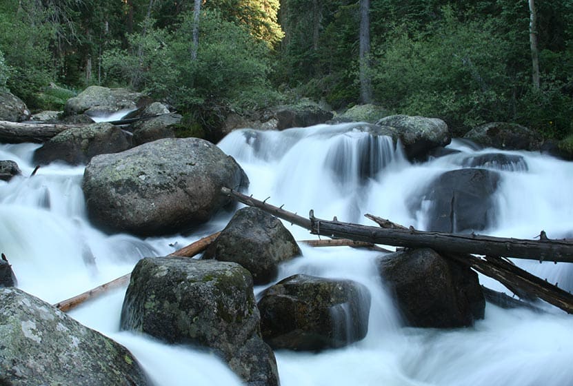
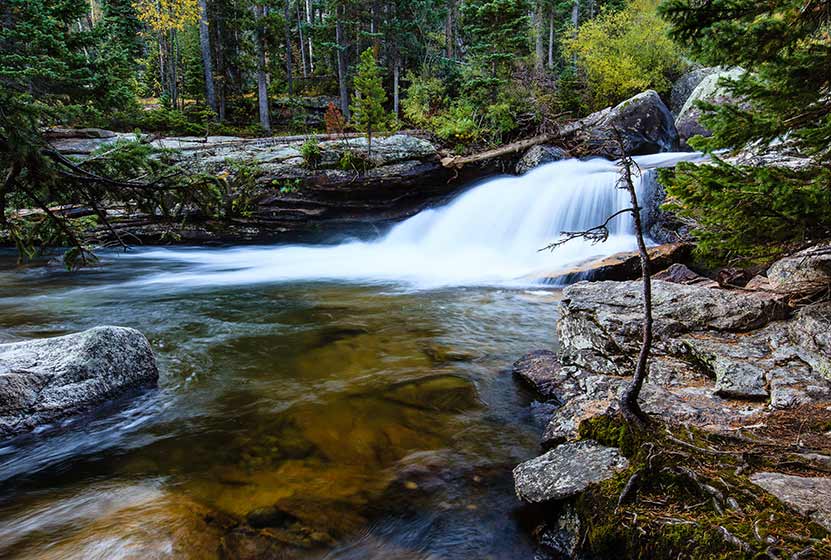
Ouzel Lake Hike in Rocky Mountain National Park
Ouzel Lake is nestled in an expansive valley in the Wild Basin, and is one of the better fishing destinations in Rocky Mountain National Park. It's a moderate, 4.9 mile, creekside hike that passes several beautiful cascade waterfalls, including one of our favorites, Ouzel Falls. Combine the hike to Ouzel Lake with an overnight, and a journey to the shores Bluebird Lake. Explore the full Ouzel Lake hike profile below for trail map, driving directions, and more tips and details to help you enjoy this adventure in Rocky Mountain National Park.
Note: Rocky Mountain National Park now requires timed entry permits from May 27th through October 10th. See the RMNP permits page for more information.
Trail Snapshot: Ouzel Lake in Rocky Mountain National Park
| Hike Distance | 9.8 miles Round Trip |
|---|---|
| Difficulty | Moderate |
| Duration | Approx 5-7 hr Round Trip |
| Trail Type | Out and Back |
| Starting Elevation | 8566' |
| Elevation Gain | Approx +1510' |
| Seasons | Spring through Fall |
| Dogs | Prohibited in RMNP |
| Hike Trail Map | Click for a Map of Ouzel Lake RMNP |
| Denver Drive Time | 1 hr 30 min |
| Driving Directions to Wild Basin Trailhead | Click for Google Map |
| Driving Directions to Winter Recreation Parking for Wild Basin Hikes | Click for Google Map |
| Town Nearest Hike | Allenspark, Colorado |
| Beauty | Lake, alpine tundra, waterfall, mountain views, meadows, river, wildlife: Abert's squirrel, elk, deer, moose, bear; wildflowers |
| Activities | Fly fishing, picnicking, hiking trails, snowshoeing, horseback riding, backcountry camping (with a permit), photography |
| Fee | Park Pass Required |
Parking & Trailhead Information for Ouzel Lake
The southeast corner of Rocky Mountain National Park boasts one of the loveliest portions in the park known as the Wild Basin. The Wild Basin Trailhead is located just 15 minutes outside of Allenspark, Colorado along Highway 115. There is a ranger station at at the Wild Basin Trailhead with toilets and drinking water available.
In the winter (October-May), Hwy 115 may not be plowed to the trailhead, and hikers will need to park their vehicles at a winter parking lot for Wild Basin hikes. Be aware that hikes from the winter parking lot add on another 3 miles of hiking (one-way). There are other small parking areas, like the Finch Lake Trailhead, that may be accessible and allow hikers to park closer to the Wild Basin Trailhead. It's important to know that Hwy 115, though titled a "highway", is a maintained dirt road, which means that it can be used by 2WD vehicles. However, after heavy rains and other severe weather, its quality may degrade until it is repaired. 4WD may be needed when snow is on the ground.
The Hike: Ouzel Lake Trail in RMNP
It's 4.9 miles one-way to Ouzel Lake. The trail begins at the Wild Basin Trailhead, and takes hikers through the central area of the Wild Basin, past three cascade waterfalls: Copeland Falls, Calypso Cascades, and Ouzel Falls.
The first waterfall, Copeland Falls, is just 0.4 mile into the hike on this first, easy segment of trail. For details on accessing both the lower and upper leaps of Copeland Falls, check out our full trail profile for Copeland Falls.
The path follows North Saint Vrain Creek until it encounters a first trail junction. The trail to the right leads past a series of backcountry campsites. These are reservable through the Rocky Mountain National Park Wilderness offices and make for a great place to stay for longer adventures into the Wild Basin area. The left-hand trail is the correct way towards the Bluebird Lake trail system and Ouzel Lake.
Having taken the left-hand trail, hikers cross a large log bridge spanning North St. Vrain Creek. Pause when you hear the sounds of an unnamed cascade that can be viewed from the bridge area. Soon after the bridge, the trail meets with a second trail junction at Calypso Cascades. Taking the right-hand trail, the cascades (named after the purple orchids that grow along the creek) come into view. The path crosses a second bridge at 1.8 miles, then things begin to get more challenging, as the trail weaves through a set of switchbacks to Ouzel Falls at 2.7 miles.
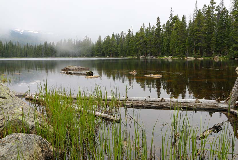
Ouzel Falls on a Wet Spring Day - Courtesy of Chris Heald
After about 0.4 mile past Ouzel Falls, the trail comes to a junction with the Bluebird Lake trail, 3.1 miles into the hike. The way to Ouzel Lake takes the Bluebird Trail (left). This final 1.8 segment of the hike to Ouzel Lake gains a ridgeline and becomes more demanding. It's a desolate segment of trail, charred by a fire in 1978. However, wildflowers make their way up through the barren landscape, and the surrounding mountain peaks come into full view due to the few trees left by the burn.
At 4.5 miles, there is a marked trail spur that leads to Ouzel Lake, bending its way around a small pond to Ouzel's northwestern shore. At the lake, you'll find more trees and a lot of marshland--and marsh = mosquitos, so be sure to bring repellant. If you are looking to try some deet-free repellant, we have had some great luck with a lemon-ecualyptus repellant made by repel. The fishing up at Ouzel Lake is great! Of course, a Colorado State fishing license is required.
Tips & Resources for Hiking to Ouzel Lake in RMNP
- Camp + Hike + Fish: Reserve one of the two backcountry camping sites along the Bluebird Trail to spend some time fishing Ouzel Lake and exploring the other destinations along the trail: Bluebird Lake, a waterfall between them, Lark Pond, and Pipit Lake. Contact the RMNP Wilderness Offices to reserve a site.
- Summer Thunderstorms: If you see clouds with dark undersides building in the west, this means that thunderstorms are likely--a typical occurrence on most summer days. Begin hikes early to avoid storms and consider turning back if weather looks threatening.
- Get there early: Parking may be somewhat limited as with many hikes in RMNP area and can get full even early in the morning.
- You're in Bear Country: Black Bears live in the Wild Basin area and are active on the months of April through November. Be aware, and dispose of your food responsibly.
- Trail Map for Wild Basin Area: Trail Map Link
- Packing List: Always pack the 10 Essentials. Download our Hiking Guide to get list and dayhiking packing checklist.
- Food Storage: There are food storage lockers available at the Wild Basin, Finch Lake, and Sandbeach Lake Trailheads. These are required for visitors staying overnight. Backcountry campers are required to use bear resistant food containers.
- Colorado Road Conditions: Colorado Road Conditions
- Photo: We would like to express our gratitude to Ed Ogle for sharing such an amazing photograph of this hike to Ouzel Lake in RMNP.
- After the Hike: Meadow Mountain Cafe
Weather
Map & Driving Directions
Click for Driving Directions
Falcon Falls in Rocky Mountain National Park
Falcon Falls is one of two waterfalls that spill from the heights above Thunder Lake in this remote part of the Wild Basin. It's a difficult and demanding 16 mile round-trip hike that requires some land navigation and backcountry travel skills. Explore the full Falcon Falls hike profile below for trail map, driving directions, and more tips and details to help you enjoy this adventure in Rocky Mountain National Park.
Note: Rocky Mountain National Park now requires timed entry permits from May 27th through October 10th. See the RMNP permits page for more information.
Trail Snapshot: Falcon Falls in Rocky Mountain National Park
| Hike Distance | 15.5 - 16.5 miles Round Trip |
|---|---|
| Difficulty | Difficult |
| Duration | 8-11 hr Round Trip |
| Trail Type | Out and Back |
| Starting Elevation | 8566' |
| Elevation Gain | Approx. +2530' |
| Seasons | Spring through Fall |
| Dogs | Prohibited in RMNP |
| Hike Trail Map for Thunder Lake | Click for a Trail Map |
| Hike Trail Map for Falcon Falls | National Geographic Trails Illustrated Map--detailed topographic map |
| Denver Drive Time | 1 hr 30 min |
| Driving Directions to Wild Basin Trailhead | Click for Google Map |
| Driving Directions to Winter Recreation Parking for Wild Basin Hikes | Click for Google Map |
| Town Nearest Hike | Allenspark, Colorado |
| Beauty | Waterfall, lake, mountain views, meadows, river, wildlife: Abert's squirrel, elk, deer, moose, bear; wildflowers |
| Activities | Picnicking, hiking trails, snowshoeing, horseback riding, backcountry camping (with a permit), photography |
| Fee | Park Pass Required |
Parking & Trailhead Information for Falcon Falls
The southeast corner of Rocky Mountain National Park boasts one of the loveliest portions in the park known as the Wild Basin. The Wild Basin Trailhead is located just 15 minutes outside of Allenspark, Colorado along Highway 115. There is a ranger station at at the Wild Basin Trailhead with toilets and drinking water available.
In the winter (October-May), Hwy 115 may not be plowed to the trailhead, and hikers will need to park their vehicles at a winter parking lot for Wild Basin hikes. Be aware that hikes from the winter parking lot add on another 3 miles of hiking (one-way). There are other small parking areas, like the Finch Lake Trailhead, that may be accessible and allow hikers to park closer to the Wild Basin Trailhead. It's important to know that Hwy 115, though titled a "highway", is a maintained dirt road, which means that it can be used by 2WD vehicles. However, after heavy rains and other severe weather, its quality may degrade until it is repaired. 4WD may be needed when snow is on the ground.
The Hike: Falcon Falls Trail in RMNP
The hike up to view Falcon Falls leads hikers past three sets of cascade waterfalls, around the shore of Thunder Lake, and up some rugged and steep terrain to Fan Falls, where Falcon Falls can be viewed in the near distance, just to the northwest. The hike from Fan Falls to Falcon can be navigated, but it's difficult and should only be attempted by hikers who have experience with land navigation in the backcountry.
Beginning at the Wild Basin Trailhead, the trail passes by Copeland Falls, a set of two cascade waterfalls just 0.4 mile into the hike. For details on accessing both the lower and upper leaps of Copeland Falls, be sure to explore our full trail profile for Copeland Falls.
The trail then follows North Saint Vrain Creek, until it meets with a trail junction. The trail to the right leads past a series of backcountry campsites, and is a slightly more direct route to Thunder Lake and Fan Falls. However, the left-hand trail is not much longer and takes hikers past two more waterfalls, Calypso Cascades and Ouzel Falls. The rest of this trail profile will explain this route.
Having taken the left-hand trail, it will soon cross a hefty log bridge spanning North St. Vrain Creek. Stop here to enjoy an unnamed set of cascades. Soon the trail will meet with a second trail junction at Calypso Cascades. The right-hand trail leads hikers to the cascades, over another bridge that crosses Cony Creek at 1.8 miles, then weaves up a set of switchbacks to Ouzel Falls at 2.7 miles.
After Ouzel Falls, the trail comes to a junction with the Bluebird Lake trail at 3.7 miles. However, the way to Fan falls passes by this junction and keeps going straight/northwest. In approximately 1.5 mile from the Bluebird Trail junction @ 5.2 miles into the hike, the trail makes a final split. The right leads up to the Lion Lakes and to Thunder Falls. The trail to the left leads up to Thunder Lake, and off-trail access to Fan Falls, and Falcon Falls.
At Thunder Lake, the way to Fan Falls requires some listening and attention to the landscape. Hikers should be familiar with backcountry travel and land navigation because this remaining segment requires hiking on unmarked and lesser traveled social trails. Hiking along the right/north side of the lake, a social trail leads back into the forest. When the trees open up into a clearing, the sounds of Fan Falls become apparent. Following the sound of the waterfall and the creek, hikers can pick their way through rock, brush, and deadfall until reaching the base of Fan Falls.
Here at Fan Falls, Falcon Falls can be seen approximately 1/4 of a mile to the the northwest. Falcon Falls is formed by a creek that spills out of Falcon Lake, a small alpine lake located about 600' above Thunder Lake. The hike over to Falcon Falls requires first descending to where the landscape is not so steep and rocky, as a lateral hike would require travel through steep and difficult terrain. After descending to less steep terrain, look for the social trail that leads over to the creek flowing out of Falcon Lake. Hiking along and up the creek that flows out of Falcon Lake, through rock and thick brush, hikers will emerge at the base of Falcon Falls. This makes for an 8 to 8.25 mile one-way hike from the Wild Basin Trailhead.
Tips & Resources for Hiking to Falcon Falls in RMNP
- TIP: A patrol cabin is located on the northeast shore of Thunder Lake. Though kept locked, the eaves can offer some limited shelter from afternoon rainstorms.
- Camping: The Thunder Lake campsite and others along this route can be reserved through the Rocky Mountain National Park Wilderness Offices. Because this is an extensive hike in rugged country, it may be wise to make this expedition a part of a multi-day trip.
- TIP: There are food storage lockers available at the Wild Basin, Finch Lake, and Sandbeach Lake Trailheads. These are required for visitors staying overnight.
- Get there early: Parking may be somewhat limited as with many hikes in RMNP area and can get full even early in the morning.
- You're in Bear Country: Black Bears live in the Wild Basin area and are active on the months of April through November. Be aware, and dispose of your food responsibly.
- Recommended Map for Rocky Mountain National Park & Falcon Falls: The trail maps provided by Rocky Mountain National Park are usually sufficient. However, for the hike up to Fan Falls, we highly recommend purchasing a National Geographic Trails Illustrated Map.
- Packing List: Always pack the 10 Essentials. Download our Hiking Guide to get list and dayhiking packing checklist.
- Colorado Road Conditions: Colorado Road Conditions
- Photo: We would like to express our gratitude to Sam Cox for sharing such an amazing photograph of this hike to Falcon Falls in RMNP.
- After the Hike: Rock Creek Tavern & Pizzeria
Weather
Map & Driving Directions
Click for Driving Directions
Sandbeach Lake Hike in Rocky Mountain National Park
Sandbeach Lake features great fishing and a beach! The lake got its name from its sandy shore that resembles that of a beach--making it one of best camping spots in Rocky Mountain National Park. It's a 4.5 mile moderate hike that climbs Copeland Moraine and crosses two creeks before arriving at this beautiful subalpine lake. With several reservable campsites along the way, Sandbeach Lake makes for a great initial multi-day backpacking trip for young families. Explore the full Sandbeach Lake hike profile below for trail map, driving directions, and more tips and details to help you enjoy this adventure in Rocky Mountain National Park.
Note: Rocky Mountain National Park now requires timed entry permits from May 27th through October 10th. See the RMNP permits page for more information.
Trail Snapshot: Sandbeach Lake in Rocky Mountain National Park
| Hike Distance | 8.4 miles Round Trip |
|---|---|
| Difficulty | Moderate |
| Duration | Approx 6 hr Round Trip |
| Trail Type | Out and Back |
| Starting Elevation | 8430′ |
| Elevation Gain | Approx +1971′ |
| Seasons | Spring through Fall, Winter Snowshoeing |
| Dogs | Prohibited in RMNP |
| Hike Trail Map | Click for a Map of Sandbeach Lake RMNP |
| Denver Drive Time | 1 hr 30 min |
| Driving Directions to Sandbeach Lake Trailhead | Click for Google Map |
| Town Nearest Hike | Allenspark, Colorado |
| Beauty | Lake, mountain views, aspen, ponderosa, limber pine, creek, wildlife: Abert’s squirrel, elk, deer, moose, bear; wildflowers |
| Activities | Picnicking, hiking trails, fishing, snowshoeing, horseback riding, backcountry camping (with a permit), photography |
| Fee | Park Pass Required |
Parking & Trailhead Information for Sandbeach Lake
The Sandbeach Lake Trailhead is located off of County Road 84 near, just about 1/2 mile west from its junction with Highway 7. See the driving directions link above for the detailed route. The trailhead is across the street from the Wild Basin Lodge and Event Center. The trailhead has toilet facilities and parking capacity of about 25 cars (includes gravel side-lot).
The Hike: Sandbeach Lake Trail in RMNP
The 4.5 mile hike (one-way) to Sandbeach Lake first heads north out of the Sandbeach Lake Trailhead, then begins a moderate climb to gain the ridge of the Copeland Moraine. The trail then follows the ridgeline west until it crosses Campers Creek at 2.3 miles. Here, the trail makes a short, but sharp, bend to the the south before continuing west/northwest. At 3.3 miles, the trail crosses a second creek, Hunters Creek, then makes a steady climb to the northern shores of Sandbeach Lake.
Campsites Along the Sandbeach Lake Trail
There are several backcountry campsites along the Sandbeach Lake Trail, making the hike up to Sandbeach Lake, a great opportunity for young families and first-time backpackers who want to do their first multi-day trip. Camping permits must be obtained through the RMNP Wilderness offices. A basic itinerary would be to drive into the park's Wilderness Office in the late morning, grab lunch, then hike to one of the campsites listed below. For a two-night trip, families could elect to camp at one of the earlier campsites: Hole in the Wall or Campers Creek. Then, day two would be a short hike up to Sandbeach Lake, a perfect place for a second night under an expanse of stars. Day three would consist of a 4.5 mile hike out to the trailhead. Be sure to call ahead to the Wilderness Office to book your sites.
Tips & Resources for Hiking to Sandbeach Lake in RMNP
- Packing List: Always pack the 10 Essentials. Download our Hiking Guide to get list and dayhiking packing checklist.
- Recommended Trail Map: We recommend the National Geographic Trails Illustrated Map which indicates the location of the Backcountry Camping Sites, and provides topo information, too.
- Get there early: Parking is limited. Arrive early to secure a parking spot at the trailhead.
- You’re in Bear Country: Black Bears live in the Wild Basin area and are active on the months of April through November. Be aware, dispose of your food responsibly, and don’t food or anything else with a strong scent in your vehicle.
- Trail Map for Wild Basin Area: Trail Map Link
- Colorado Road Conditions: Colorado Road Conditions
- Photo: We would like to express our gratitude to Reese Lloyd for sharing such great photos of this hike to Sandbeach Lake in RMNP.
- After the Hike: Meadow Mountain Cafe in Allenspark, Colorado
Weather
Map & Driving Directions
Click for Driving Directions
Trio Falls Hike in Rocky Mountain National Park
Trio Falls is among the most stunning waterfalls that you will encounter in Rocky Mountain National Park, or in Colorado. But it comes at a price: A 15-mile round-trip, demanding hike. Because of this, the hike up to Trio Falls may best be part of an overnight camping trip in the park. Explore the full Trio Falls hike profile below for trail map, driving directions, and more tips and details to help you enjoy this adventure in Rocky Mountain National Park.
Note: Rocky Mountain National Park now requires timed entry permits from May 27th through October 10th. See the RMNP permits page for more information.
Trail Snapshot: Trio Falls in Rocky Mountain National Park
| Hike Distance | 14.8 miles Round Trip |
|---|---|
| Difficulty | Difficult |
| Duration | Approx 8-10 hr Round Trip |
| Trail Type | Out and Back |
| Starting Elevation | 8566' |
| Elevation Gain | Approx. +2760' |
| Seasons | Spring through Fall |
| Dogs | Prohibited in RMNP |
| Hike Trail Map | Click for a Map of Trio Falls RMNP |
| Recommended Trail Map | National Geographic Trails Illustrated Map |
| Denver Drive Time | 1 hr 30 min |
| Driving Directions to Wild Basin Trailhead | Click for Google Map |
| Driving Directions to Winter Recreation Parking for Wild Basin Hikes | Click for Google Map |
| Town Nearest Hike | Allenspark, Colorado |
| Beauty | Waterfall, lake, mountain views, meadows, river, wildlife: Abert's squirrel, elk, deer, moose, bear; wildflowers |
| Activities | Picnicking, hiking trails, snowshoeing, horseback riding, backcountry camping (with a permit), photography |
| Fee | Park Pass Required |
Parking & Trailhead Information for Trio Falls
The southeast corner of Rocky Mountain National Park boasts one of the loveliest portions in the park known as the Wild Basin. The Wild Basin Trailhead is located just 15 minutes outside of Allenspark, Colorado along Highway 115. There is a ranger station at at the Wild Basin Trailhead with toilets and drinking water available.
In the winter (October-May), Hwy 115 may not be plowed to the trailhead, and hikers will need to park their vehicles at a winter parking lot for Wild Basin hikes. Be aware that hikes from the winter parking lot add on another 3 miles of hiking (one-way). There are other small parking areas, like the Finch Lake Trailhead, that may be accessible and allow hikers to park closer to the Wild Basin Trailhead. It's important to know that Hwy 115, though titled a "highway", is a maintained dirt road, which means that it can be used by 2WD vehicles. However, after heavy rains and other severe weather, its quality may degrade until it is repaired. 4WD may be needed when snow is on the ground.
The Hike: Trio Falls Trail in RMNP
The hike up to Trio Falls in Rocky Mountain National Park combines both distance and a fair amount of elevation gain to make this a very challenging hike. Because Trio Falls is 7 1/2 miles from the trailhead, few make the journey; but the solitude and the sights are worth it to those who make the effort. Because the round-trip hike is 15+ miles, it's advisable to make this hike a part of a multi-day camping trip in the park. If you are considering camping, there are several reservable backcountry camping spots in the Wild Basin area, and camping permits can be obtained through the RMNP Wilderness offices.
Trio Falls is located between Lion Lake #1 and Lion Lake #2 in the Wild Basin. For a detailed trail description of the almost 7-mile hike to Lion Lake #1, which takes hikers past three other waterfalls, be sure to explore the trail profile for Lion Lake #1.
At Lion Lake #1, there is a social trail that runs along the right/east side of the lake. Because this next segment is on unmaintained trails in a remote section of the park, hikers should possess both land navigation skills, map, and equipment. This social trail leads for about 1/2 mile along the lake, beyond into rocky terrain, and eventually to the waterfall.
There are a lower and an upper set of cascades to Trio Falls. Following the trail past the lower cascades requires a scramble and negotiating an passage through thick willows and rock. Hikers should exercise extra caution in this wet and rocky terrain.
Tips & Resources for Hiking to Trio Falls in RMNP
- Recommended Trail Map: We recommend the National Geographic Trails Illustrated Map which indicates the location of Trio Falls, and provides topo information.
- TIP: There are food storage lockers available at the Wild Basin, Finch Lake, and Sandbeach Lake Trailheads.
- Itinerary: It should go without saying, but be sure to always leave an itinerary with family and/or friends, and give them a call when you are back at the trailhead or within cell range.
- Another Waterfall: If you are lucky and there is an ample flow of water, another waterfall can be spotted pouring down from the cliffs near Trio Falls.
- Get there early: Parking may be limited as with many hikes in RMNP area and can get full even early in the morning.
- You're in Bear Country: Black Bears live in the Wild Basin area and are active on the months of April through November. Be aware, and dispose of your food responsibly.
- Trail Map for Wild Basin Area: Trail Map Link
- Packing List: Always pack the 10 Essentials. Download our Hiking Guide to get list and dayhiking packing checklist.
- Colorado Road Conditions: Colorado Road Conditions
- Photo: We would like to express our gratitude to Steven Bratman for sharing such an amazing photograph of this hike to Trio Falls in RMNP.
- After the Hike: Rock Creek Tavern & Pizzeria
Weather
Map & Driving Directions
Click for Driving Directions
Lion Lake in Rocky Mountain National Park
The Lion Lake #1 in Rocky Mountain National Park boasts a dramatic alpine landscape hidden away in the northwestern corner of the Wild Basin. The trail to this high-mountain lake passes several waterfalls and offers access to other lakes and surrounding peaks. Because the Lions lake is more remote, a trip to it may require an overnight stay at one of RMNP's backcountry camping sites. Explore the full Lion Lake #1 hike profile below for trail map, driving directions, and more tips and details to help you enjoy this adventure in Rocky Mountain National Park.
Note: Rocky Mountain National Park now requires timed entry permits from May 27th through October 10th. See the RMNP permits page for more information.
Trail Snapshot: Lion Lake #1 in Rocky Mountain National Park
| Hike Distance | 14 miles Round Trip |
|---|---|
| Difficulty | Difficult |
| Duration | 7-10 hr Round Trip |
| Trail Type | Out and Back |
| Starting Elevation | 8566' |
| Elevation Gain | Approx. +2565' |
| Seasons | Spring through Fall |
| Dogs | Prohibited in RMNP |
| Hike Trail Map | Click for a Map of Lion Lakes RMNP |
| Recommended Trail Map | National Geographic Trails Illustrated Map |
| Denver Drive Time | 1 hr 30 min |
| Driving Directions to Wild Basin Trailhead | Click for Google Map |
| Driving Directions to Winter Recreation Parking for Wild Basin Hikes | Click for Google Map |
| Town Nearest Hike | Allenspark, Colorado |
| Beauty | Lake, waterfall, mountain views, meadows, river, wildlife: Abert's squirrel, elk, deer, moose, bear; wildflowers |
| Activities | Picnicking, hiking trails, snowshoeing, horseback riding, backcountry camping (with a permit), photography |
| Fee | Park Pass Required |
Parking & Trailhead Information for Lion Lake
The southeast corner of Rocky Mountain National Park boasts one of the loveliest portions in the park known as the Wild Basin. The Wild Basin Trailhead is located just 15 minutes outside of Allenspark, Colorado along Highway 115. There is a ranger station at at the Wild Basin Trailhead with toilets and drinking water available.
In the winter (October-May), Hwy 115 may not be plowed to the trailhead, and hikers will need to park their vehicles at a winter parking lot for Wild Basin hikes. Be aware that hikes from the winter parking lot add on another 3 miles of hiking (one-way). There are other small parking areas, like the Finch Lake Trailhead, that may be accessible and allow hikers to park closer to the Wild Basin Trailhead. It's important to know that Hwy 115, though titled a "highway", is a maintained dirt road, which means that it can be used by 2WD vehicles. However, after heavy rains and other severe weather, its quality may degrade until it is repaired. 4WD may be needed when snow is on the ground.
The Hike: Lion Lake #1 Trail in RMNP
It's seven miles one-way to Lion Lake #1, which requires that hikers get a very early start, or build this hike into a multi-day camping trip in Rocky Mountain National Park. If you are considering camping, there are several reservable backcountry camping spots in the Wild Basin area, and camping permits can be obtained through the RMNP Wilderness offices.
The trail begins at the Wild Basin Trailhead, and takes hikers through the central area of the Wild Basin, past three sets of cascade waterfalls, then up into the highest reaches of this lesser visited section of the National Park.
The first waterfall, Copeland Falls, is just 0.4 mile into the hike. For details on accessing both the lower and upper leaps of Copeland Falls, be sure to explore our full trail profile for Copeland Falls.
The trail then traces the path of North Saint Vrain Creek, until it encounters a junction. The trail to the right leads past a series of backcountry campsites mentioned above, and is a slightly more direct route to Lion Lake #1. However, the left-hand trail is not much longer and leads to two more waterfalls, Calypso Cascades and Ouzel Falls. The rest of this trail profile will explain this route.
Having taken the left-hand trail, you'll cross a large log bridge spanning North St. Vrain Creek. Pause when you hear the sounds of an unnamed cascade that can be viewed from the bridge area. Soon after the bridge, the trail will meet with a second trail junction at Calypso Cascades. Taking the right-hand trail, hikers will soon encounter the sight and spray of the cascades. Then trail will cross over another bridge at 1.8 miles, then things begin to get more challenging, as the trail weaves through a set of switchbacks to Ouzel Falls at 2.7 miles. Ouzel Falls, while not large when compared to Alberta or Fern Falls, may be one of the most stunning waterfalls in Rocky Mountain National Park.
After Ouzel Falls, the trail comes to a junction with the Bluebird Lake trail at 3.1 miles. However, the way to the Lion Lake passes by this junction and keeps going straight/northwest.
In approximately 1.5 mile from the Bluebird Trail junction, the trail makes a final split. The trail to the left leads up to Thunder Lake and Fan Falls. The right leads up to the Lion Lakes and is a hiker-only trail (no horses or pack animals beyond this point). Now you're entering the very heart of Rocky Mountain National Park.
The trail now becomes undulating, with spots of level ground, meadows, boulders, and marsh. It's the kind of diversity that characterizes the beautiful high-country of Colorado. On the approach to Lion Lake #1, Mt. Alice comes into view with it's sheer rock wall and pyramid peak. Moving into the Lion Lakes area, beautiful meadows and marsh hold the delight of wildflowers, and the nuisance of mosquitos.
Following a social trail from the shores of Lion Lake #1, hikers can push on to the Trio Falls and Lion Lake #2. Because this next segment is on unmaintained trails in a remote section of the park, hikers should possess both land navigation skills, map, and equipment.
Tips & Resources for Hiking to Lion Lake #1 in RMNP
- TIP: There are food storage lockers available at the Wild Basin, Finch Lake, and Sandbeach Lake Trailheads. These are required for visitors staying overnight. Make sure there is nothing that smells good to bears left in your car (that includes air fresheners).
- Get there early: Parking may be somewhat limited as with many hikes in RMNP area and can get full even early in the morning.
- Camping: The Thunder Lake campsite and others along this route can be reserved through the Rocky Mountain National Park Wilderness Offices. Because this is an extensive hike in rugged country, it may be wise to make this expedition a part of a multi-day trip.
- You're in Bear Country: Black Bears live in the Wild Basin area and are active on the months of April through November. Be aware, and dispose of your food responsibly.
- Recommended Trail Map for Lion Lake Hike: National Geographic Trails Illustrated Map
- Packing List: Always pack the 10 Essentials. Download our Hiking Guide to get list and dayhiking packing checklist.
- Colorado Road Conditions: Colorado Road Conditions
- Photo: We would like to express our gratitude to Shea Oliver for sharing such amazing photographs of this hike to Lion Lake in RMNP.
- After the Hike: Rock Creek Tavern & Pizzeria
Weather
Map & Driving Directions
Click for Driving Directions
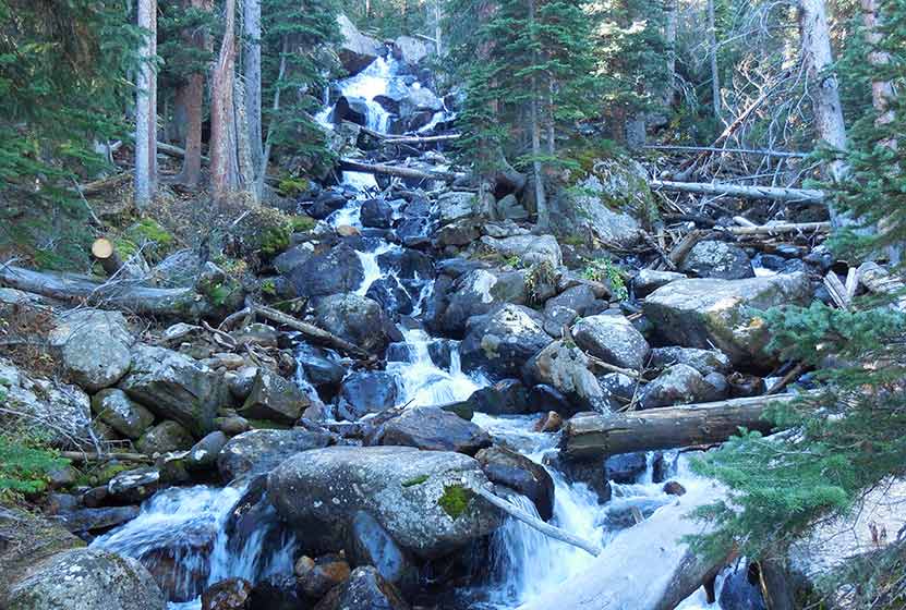
Fan Falls in Rocky Mountain National Park
Fan Falls is tucked away in the high reaches of the Wild Basin of Rocky Mountain National Park. This 15.5 mile, difficult trek, leads to a long set of segmented cascades spilling out of the heights and streaming down into Thunder Lake. This garden of water, wildflowers and rock is a perfect escape for those looking for a demanding hike to a more secluded spot. Explore the entire Fan Falls hike profile below for trail map, driving directions, and more tips and details to help you enjoy this adventure in Rocky Mountain National Park.
Note: Rocky Mountain National Park now requires timed entry permits from May 27th through October 10th. See the RMNP permits page for more information.
Trail Snapshot: Fan Falls in Rocky Mountain National Park
| Hike Distance | 15.5 miles Round Trip |
|---|---|
| Difficulty | Difficult |
| Duration | 8-10+ hr Round Trip |
| Trail Type | Out and Back |
| Starting Elevation | 8566' |
| Elevation Gain | Approx. +2530' |
| Seasons | Late Spring through Early Fall |
| Dogs | Prohibited in RMNP |
| Hike Trail Map | National Geographic Trails Illustrated Map |
| Denver Drive Time | 1 hr 30 min |
| Driving Directions to Wild Basin Trailhead | Click for Google Map |
| Driving Directions to Winter Recreation Parking for Wild Basin Hikes | Click for Google Map |
| Town Nearest Hike | Allenspark, Colorado |
| Beauty | Waterfall, lake, mountain views, meadows, river, wildlife: Abert's squirrel, elk, deer, moose, bear; wildflowers |
| Activities | Picnicking, hiking trails, snowshoeing, horseback riding, backcountry camping (with a permit), photography |
| Fee | Park Pass Required |
A Stream Along the Cascades of Fan Falls
Parking & Trailhead Information for Fan Falls
The southeast corner of Rocky Mountain National Park boasts one of the loveliest portions in the park known as the Wild Basin. The Wild Basin Trailhead is located just 15 minutes outside of Allenspark, Colorado along Highway 115. There is a ranger station at at the Wild Basin Trailhead with toilets and drinking water available.
In the winter (October-May), Hwy 115 may not be plowed to the trailhead, and hikers will need to park their vehicles at a winter parking lot for Wild Basin hikes. Be aware that hikes from the winter parking lot add on another 3 miles of hiking (one-way). There are other small parking areas, like the Finch Lake Trailhead, that may be accessible and allow hikers to park closer to the Wild Basin Trailhead. It's important to know that Hwy 115, though titled a "highway", is a maintained dirt road, which means that it can be used by 2WD vehicles. However, after heavy rains and other severe weather, its quality may degrade until it is repaired. 4WD may be needed when snow is on the ground.
The Hike: Fan Falls Trail in RMNP
The hike up to Fan Falls leads through the central area of the Wild Basin, taking hikers past three sets of cascade waterfalls, around the shore of Thunder Lake, and finally to a lonely creek dropping into a series of rocky cascades.
Beginning at the Wild Basin Trailhead, the trail passes by Copeland Falls, a set of two cascade waterfalls just 0.4 mile into the hike. For details on accessing both the lower and upper leaps of Copeland Falls, be sure to explore our full trail profile for Copeland Falls.
Copeland Falls - Photo Courtesy of Ben Graham
The trail then follows North Saint Vrain Creek, until it meets with a trail junction. The trail to the right leads past a series of backcountry campsites, and is a slightly more direct route to Thunder Lake and Fan Falls. However, the left-hand trail is not much longer and takes hikers past two more waterfalls, Calypso Cascades and Ouzel Falls. The rest of this trail profile will explain this route.
Having taken the left-hand trail, it will soon cross a hefty log bridge spanning North St. Vrain Creek. Stop here to enjoy an unnamed set of cascades. Soon the trail will meet with a second trail junction at Calypso Cascades. The right-hand trail leads hikers to the cascades, over another bridge that crosses Cony Creek at 1.8 miles, then weaves up a set of switchbacks to Ouzel Falls at 2.7 miles.
Calypso Cascades - Photo Courtesy of Jeff Kramer
After Ouzel Falls, the trail comes to a junction with the Bluebird Lake trail at 3.7 miles. However, the way to Fan falls passes by this junction and keeps going straight/northwest. In approximately 1.5 mile from the Bluebird Trail junction, the trail makes a final split. The right leads up to the Lion Lakes and to Thunder Falls. The trail to the left leads up to Thunder Lake and Fan Falls.
At Thunder Lake, the way to Fan Falls requires some listening and attention to the landscape. Hikers should be familiar with backcountry travel and land navigation because this remaining segment requires hiking on unmarked and lesser traveled social trails. Hiking along the right/north side of the lake, the way leads into the forest. When the trees open up into a clearing, the sounds of Fan Falls become apparent. Following the sound of the waterfall and the creek, hikers can pick their way through rock, brush, and deadfall until reaching the base of Fan Falls. Bluebells and other wildflowers grow out from between the rock, painting the splash and spray of the cascades with color.
A Pond Above Fan Falls in RMNP
The source of Fan Falls can be accessed by hiking higher to the area above the cascades. Here, a small pond holding the meltwater from the winter's snow reflects the towering and craggy peaks that surround it.
The return hike traces the same route. However, one change can be made: Instead of taking the trail back to Ouzel Falls and Calypso Cascades, hikers can take the trail that stays to the North/left of North St. Vrain creek and passes the several backcountry campsites.
Tips & Resources for Hiking to Fan Falls in RMNP
- Camping: The Thunder Lake campsite and others along this route can be reserved through the Rocky Mountain National Park Wilderness Offices. Because this is an extensive hike in rugged country, it may be wise to make this expedition a part of a multi-day trip.
- Lockers: There are food storage lockers available at the Wild Basin, Finch Lake, and Sandbeach Lake Trailheads. These are required for visitors staying overnight.
- Get there early: Parking may be somewhat limited as with many hikes in RMNP area and can get full even early in the morning.
- You're in Bear Country: Black Bears live in the Wild Basin area and are active on the months of April through November. Be aware, and dispose of your food responsibly.
- Recommended Map for Rocky Mountain National Park: The trail maps provided by Rocky Mountain National Park are usually sufficient. However, for the hike up to Fan Falls, we highly recommend purchasing a National Geographic Trails Illustrated Map.
- Packing List: Always pack the 10 Essentials. Download our Hiking Guide to get list and dayhiking packing checklist.
- Colorado Road Conditions: Colorado Road Conditions
- Photo: We would like to express our gratitude to Shea Oliver for sharing such amazing photographs of this hike to Fan Falls in RMNP.
- After the Hike: Meadow Mountain Cafe in Allenspark, CO
Weather
Map & Driving Directions
Click for Driving Directions