Fan Falls is tucked away in the high reaches of the Wild Basin of Rocky Mountain National Park. This 15.5 mile, difficult trek, leads to a long set of segmented cascades spilling out of the heights and streaming down into Thunder Lake. This garden of water, wildflowers and rock is a perfect escape for those looking for a demanding hike to a more secluded spot. Explore the entire Fan Falls hike profile below for trail map, driving directions, and more tips and details to help you enjoy this adventure in Rocky Mountain National Park.
Note: Rocky Mountain National Park now requires timed entry permits from May 27th through October 10th. See the RMNP permits page for more information.
Trail Snapshot: Fan Falls in Rocky Mountain National Park
| Hike Distance | 15.5 miles Round Trip |
|---|---|
| Difficulty | Difficult |
| Duration | 8-10+ hr Round Trip |
| Trail Type | Out and Back |
| Starting Elevation | 8566′ |
| Elevation Gain | Approx. +2530′ |
| Seasons | Late Spring through Early Fall |
| Dogs | Prohibited in RMNP |
| Hike Trail Map | National Geographic Trails Illustrated Map |
| Denver Drive Time | 1 hr 30 min |
| Driving Directions to Wild Basin Trailhead | Click for Google Map |
| Driving Directions to Winter Recreation Parking for Wild Basin Hikes | Click for Google Map |
| Town Nearest Hike | Allenspark, Colorado |
| Beauty | Waterfall, lake, mountain views, meadows, river, wildlife: Abert’s squirrel, elk, deer, moose, bear; wildflowers |
| Activities | Picnicking, hiking trails, snowshoeing, horseback riding, backcountry camping (with a permit), photography |
| Fee | Park Pass Required |
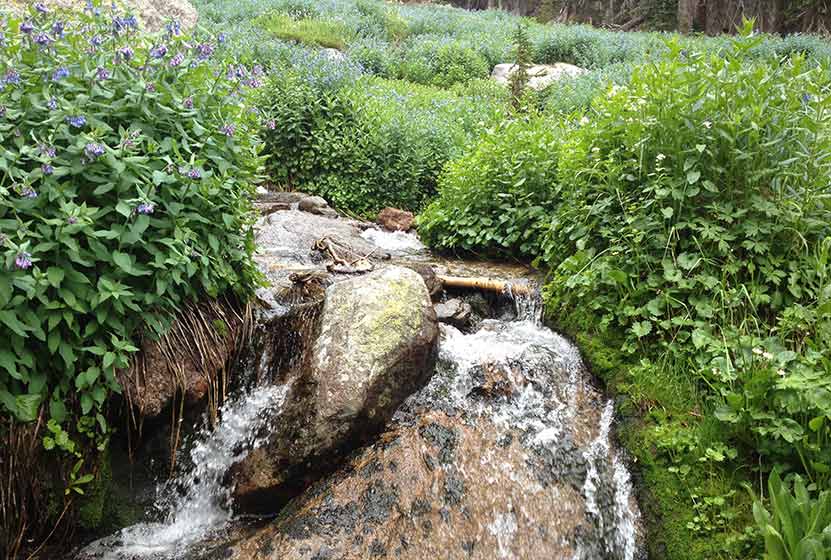
A Stream Along the Cascades of Fan Falls
Parking & Trailhead Information for Fan Falls
The southeast corner of Rocky Mountain National Park boasts one of the loveliest portions in the park known as the Wild Basin. The Wild Basin Trailhead is located just 15 minutes outside of Allenspark, Colorado along Highway 115. There is a ranger station at at the Wild Basin Trailhead with toilets and drinking water available.
In the winter (October-May), Hwy 115 may not be plowed to the trailhead, and hikers will need to park their vehicles at a winter parking lot for Wild Basin hikes. Be aware that hikes from the winter parking lot add on another 3 miles of hiking (one-way). There are other small parking areas, like the Finch Lake Trailhead, that may be accessible and allow hikers to park closer to the Wild Basin Trailhead. It’s important to know that Hwy 115, though titled a “highway”, is a maintained dirt road, which means that it can be used by 2WD vehicles. However, after heavy rains and other severe weather, its quality may degrade until it is repaired. 4WD may be needed when snow is on the ground.
The Hike: Fan Falls Trail in RMNP
The hike up to Fan Falls leads through the central area of the Wild Basin, taking hikers past three sets of cascade waterfalls, around the shore of Thunder Lake, and finally to a lonely creek dropping into a series of rocky cascades.
Beginning at the Wild Basin Trailhead, the trail passes by Copeland Falls, a set of two cascade waterfalls just 0.4 mile into the hike. For details on accessing both the lower and upper leaps of Copeland Falls, be sure to explore our full trail profile for Copeland Falls.
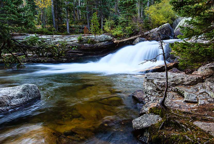
Copeland Falls – Photo Courtesy of Ben Graham
The trail then follows North Saint Vrain Creek, until it meets with a trail junction. The trail to the right leads past a series of backcountry campsites, and is a slightly more direct route to Thunder Lake and Fan Falls. However, the left-hand trail is not much longer and takes hikers past two more waterfalls, Calypso Cascades and Ouzel Falls. The rest of this trail profile will explain this route.
Having taken the left-hand trail, it will soon cross a hefty log bridge spanning North St. Vrain Creek. Stop here to enjoy an unnamed set of cascades. Soon the trail will meet with a second trail junction at Calypso Cascades. The right-hand trail leads hikers to the cascades, over another bridge that crosses Cony Creek at 1.8 miles, then weaves up a set of switchbacks to Ouzel Falls at 2.7 miles.
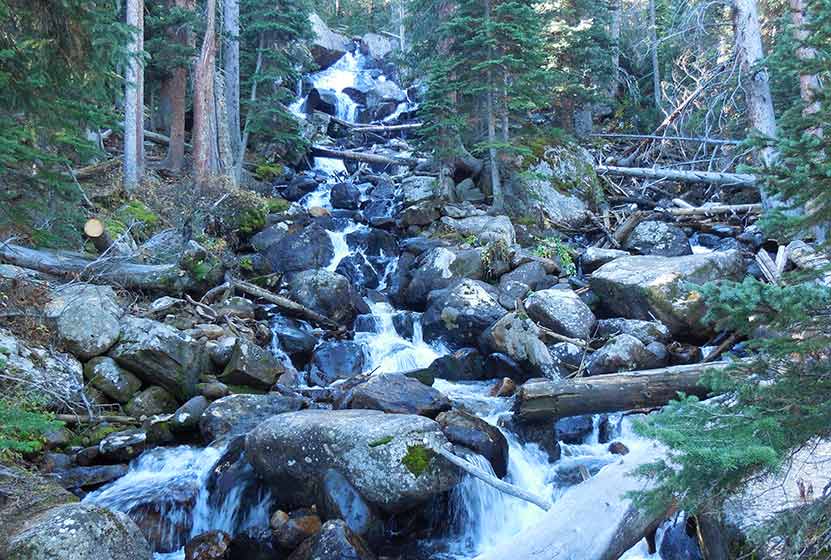
Calypso Cascades – Photo Courtesy of Jeff Kramer
After Ouzel Falls, the trail comes to a junction with the Bluebird Lake trail at 3.7 miles. However, the way to Fan falls passes by this junction and keeps going straight/northwest. In approximately 1.5 mile from the Bluebird Trail junction, the trail makes a final split. The right leads up to the Lion Lakes and to Thunder Falls. The trail to the left leads up to Thunder Lake and Fan Falls.
At Thunder Lake, the way to Fan Falls requires some listening and attention to the landscape. Hikers should be familiar with backcountry travel and land navigation because this remaining segment requires hiking on unmarked and lesser traveled social trails. Hiking along the right/north side of the lake, the way leads into the forest. When the trees open up into a clearing, the sounds of Fan Falls become apparent. Following the sound of the waterfall and the creek, hikers can pick their way through rock, brush, and deadfall until reaching the base of Fan Falls. Bluebells and other wildflowers grow out from between the rock, painting the splash and spray of the cascades with color.
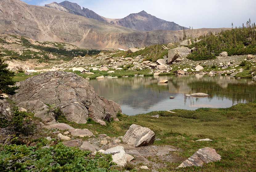
A Pond Above Fan Falls in RMNP
The source of Fan Falls can be accessed by hiking higher to the area above the cascades. Here, a small pond holding the meltwater from the winter’s snow reflects the towering and craggy peaks that surround it.
The return hike traces the same route. However, one change can be made: Instead of taking the trail back to Ouzel Falls and Calypso Cascades, hikers can take the trail that stays to the North/left of North St. Vrain creek and passes the several backcountry campsites.

Tips & Resources for Hiking to Fan Falls in RMNP
- Camping: The Thunder Lake campsite and others along this route can be reserved through the Rocky Mountain National Park Wilderness Offices. Because this is an extensive hike in rugged country, it may be wise to make this expedition a part of a multi-day trip.
- Lockers: There are food storage lockers available at the Wild Basin, Finch Lake, and Sandbeach Lake Trailheads. These are required for visitors staying overnight.
- Get there early: Parking may be somewhat limited as with many hikes in RMNP area and can get full even early in the morning.
- You’re in Bear Country: Black Bears live in the Wild Basin area and are active on the months of April through November. Be aware, and dispose of your food responsibly.
- Recommended Map for Rocky Mountain National Park: The trail maps provided by Rocky Mountain National Park are usually sufficient. However, for the hike up to Fan Falls, we highly recommend purchasing a National Geographic Trails Illustrated Map.
- Packing List: Always pack the 10 Essentials. Download our Hiking Guide to get list and dayhiking packing checklist.
- Colorado Road Conditions: Colorado Road Conditions
- Photo: We would like to express our gratitude to Shea Oliver for sharing such amazing photographs of this hike to Fan Falls in RMNP.
- After the Hike: Meadow Mountain Cafe in Allenspark, CO
Weather
Map & Driving Directions
Click for Driving Directions


