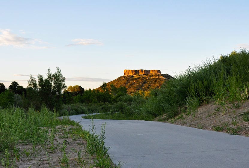
Daniel's Park Hikes
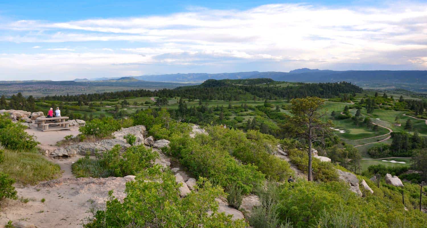
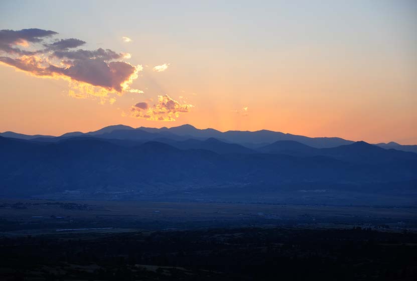
Best sunsets in Denver! You can see mountains upon mountains of Colorado's Front Range. Take a picnic dinner and pull off at one of the many picnic areas along Daniels Park Road. There are several hiking options detailed below for Daniel's park. To get all the details, scroll down and explore the trail snapshot, profile, and tips below.
Trail Snapshot: Daniel's Park Hike
| Hike Distance | 0.2, 3, or 5.4 Miles |
|---|---|
| Difficulty | Easy |
| Duration | 20 min to 2.5 hrs |
| Trail Type | Out and Back |
| Seasons | All Season |
| Dogs | Allowed on Leash |
| Hike Trail Map | Click for a Trail Map |
| Denver Drive Time | 35 min |
| Directions | Click for Google Map |
| Town Nearest Hike | Littleton, Colorado |
| Beauty | Front Range Views, Rock Formations, Bison |
| Activities | Picnic Areas, Shelter House with Fireplace, Bison viewing area, Hiking |
We are featuring Daniel's Park ,not for it's trails, but because it has one of the best views of the Front Range near Denver. From the park, you can see Pikes Peak in the South, Mt. Evans in the West, and Longs Peak in the North. The trails are not handicap accessible, but the shelter house is (after a bit of a bump trail), and is a perfect place to watch the sun set.
Here is the lowdown on the trails at Daniel's Park: They are undeveloped. The park has been around for nearly 100 years but has somehow escaped being developed. However, it's close to south Denver and has some great features, so we've come up with a few different hiking options below.
The Short Daniel's Park Hike - Park at the Shelter House and begin walking north through the undeveloped trails along the top of the bluff. We like to take a picnic dinner up here and a lot of folks bring firewood and enjoy the sunset by the fire. There are about a quarter mile of trails that weave through the rock and back out towards the road.
3 Mile Daniel's Park Hike - Again, start at the Shelter House and head North following the top of the bluff as it parallels the road. You can extend your hike by hiking North along the road until it intersects with Grigs Road - About 1.5 Miles. Hike back to Daniel's Park Shelter House for a 3 Mile round trip hike.
5.4 Mile Daniel's Park Hike - Continue the 1.5 mile hike by taking a left onto Grigs road. Cross to the Northeast side of the Grigs, then shortly after you cross, you'll come upon a green fence and the Douglas County East/West Trail. Your can take that trail West (left) to the Grigs Road Trailhead, adding an additional 1.2 miles to your hike (5.4 Miles Round Trip). Click Here for a Google Map that traces the route along Daniel's Park and Grigs Road.
Douglas County plans to build this East/West trail into a 26 mile system linking Chatfield Reservoir to the town of Parker, Colorado. Click here for the map of the East/West Trail and proposed trails in Douglas County. Denver Mountain Parks and Douglas County have developed a master plan to improve both the park and the roads in the area. You can find an overview at the Douglas County Park site.
Tips & Resources for Visiting Daniel's Park:
- TIP: Keep an eye on the skies - Douglas County has one of the highest lightning strike rates in the country and Daniel's Park is one of the higher points.
- TIP: Bison Viewing - The Bison can be found in an enclosed pasture on both sides of the road.However, the Bison are usually found grazing in the section of the park that is directly across the street from the shelter house.
- Trail Map for Daniel's Park: Trail Map Link
- Colorado Road Conditions: Colorado Road Conditions
Weather
Map & Driving Directions
Click for Driving Directions

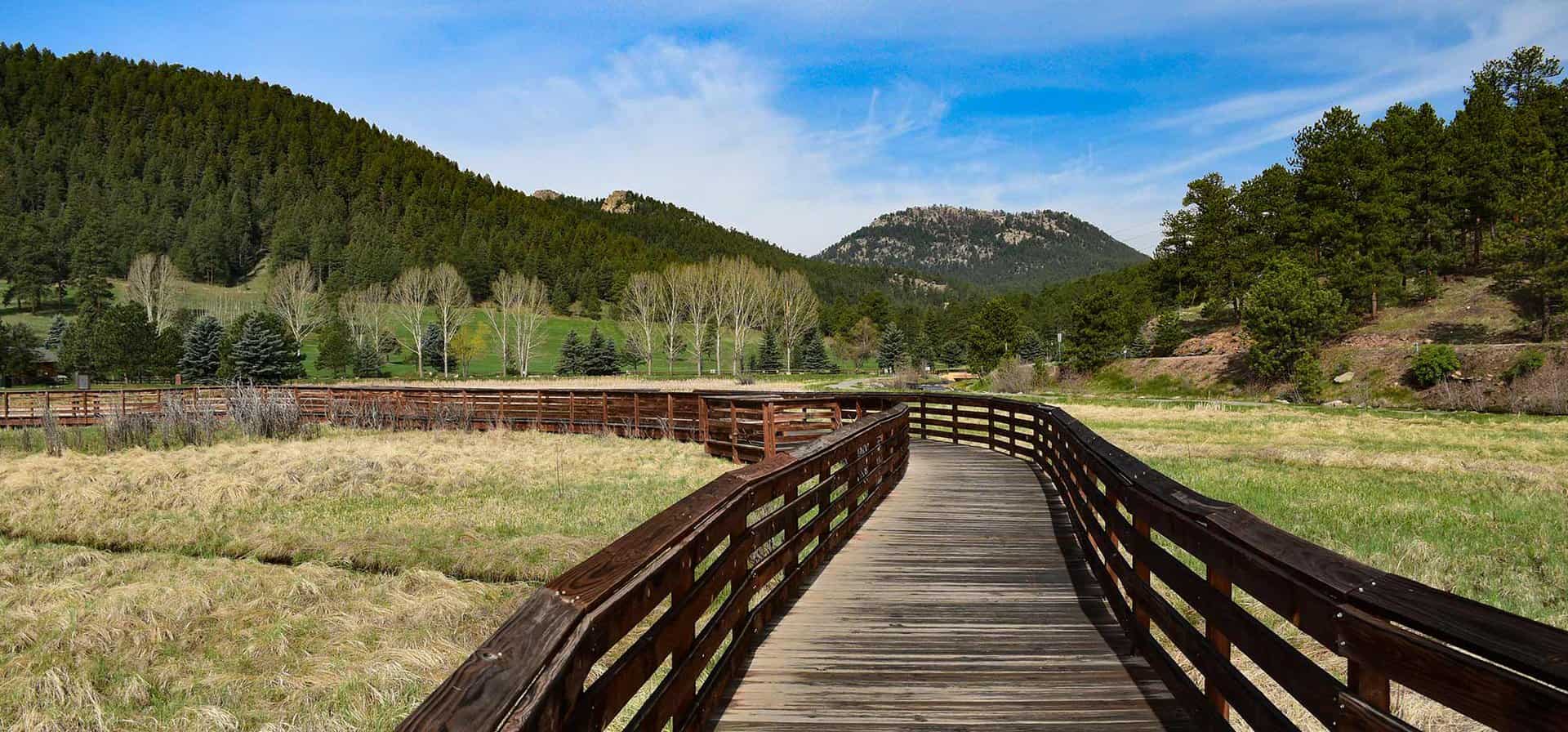
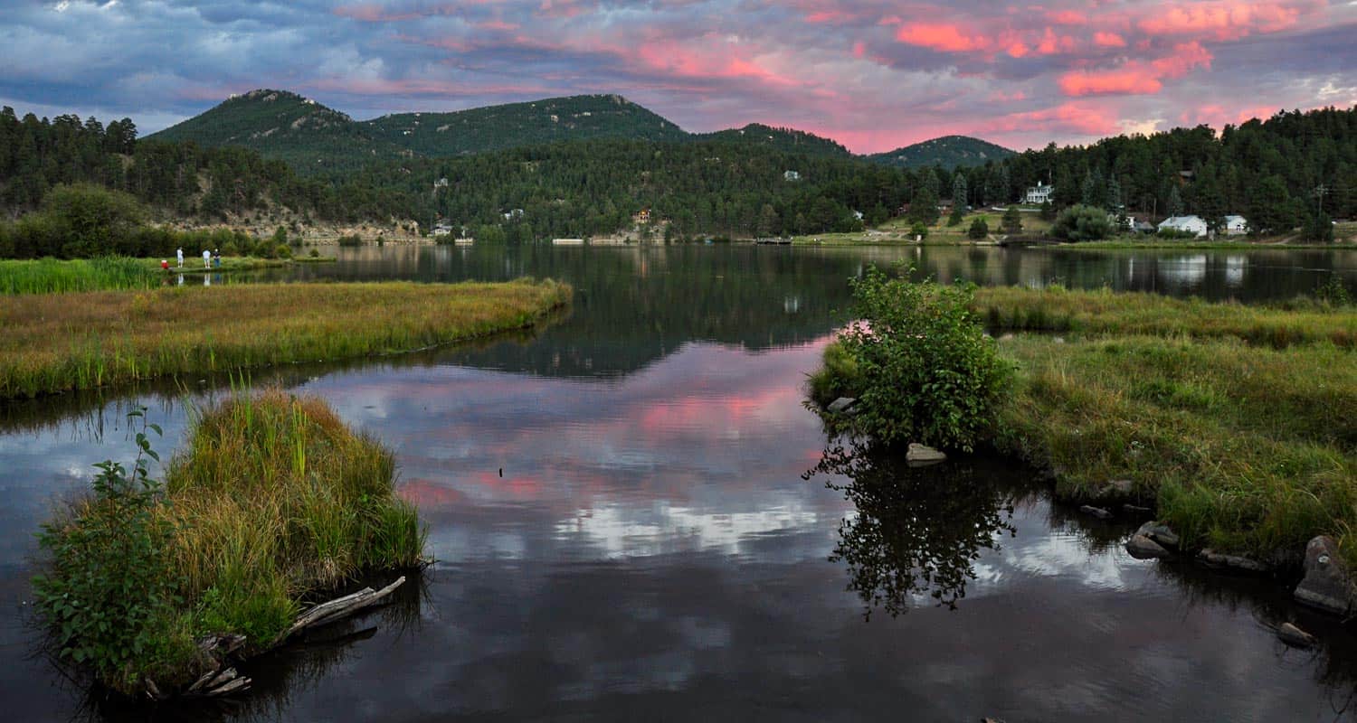
Evergreen Lake Trail
This Colorado hike (more of a stroll) is a perfect way to spend a Saturday morning. You can rent canoes and sailboats from the nature center and warming house. In the winter, the Evergreen Lake transforms into an ice skating wonderland. Explore this hike profile for all the details.
Trail Snapshot: Evergreen Lake Trail
| Hike Distance | 1.3 mile Round Trip |
|---|---|
| Difficulty | Easy |
| Duration | Approx 45 min Round Trip |
| Trail Type | Loop |
| Seasons | All |
| Dogs | Allowed On Leash |
| Hike Trail Map | Click for a Trail Map |
| Denver Drive Time | 40 min |
| Driving Directions to Evergreen Lake Trail | Click for Google Map |
| Town Nearest Hike | Evergreen, Colorado |
| Beauty | Lake, sunsets, wetlands, wildlife: elk & migratory birds |
| Activities | Picnic area, hiking trails, boating, fishing, ice skating |
| Handicap Accessible | Portions of this Trail are Handicap Accessible |
The Hike: Evergreen Lake Trail:
Evergreen Lake Trail is a 1.3 mile loop in the quaint mountain town of Evergreen, Colorado. If you have a young family like us, and are looking for an easy hike near Denver, this is a great choice.
From the Evergreen Lake house, the trail winds along a boardwalk, through a wetlands area, then towards town. If you are going this way (clockwise) around the lake, be sure to take the high path when you come to where the trail splits. The lower path is more of a fishing trail that soon becomes difficult to navigate. You can take the high path into town or over the dam and to the backside of the lake.
Along the back side of Evergreen Lake stands the old Warming House and Nature Center, operated by the Evergreen Audubon Society. Be sure to check their site for their seasonal hours. At the boathouse, the Evergreen Park & Recreation District operates boat rental and concessions. Their hours are seasonal as well. You can visit Evergreen Parks & Rec. boating page for rental info and hours. In the Winter, the lake transforms into an ice skating wonderland that rivals New York's Rockefeller Square. Skate rental and admission fees can be found on the Hockey and Skating page on the Evergreen Parks District Site.
Tips & Resources for Hiking Evergreen Lake Trail :
- TIP: Like we mentioned above, take the high path along the road when walking clockwise around the lake.
- TIP: Make it a day. There are several hikes near Evergreen to enjoy. As well, the lake is very accessible from town, so you can walk in, enjoy lunch or coffee, then hike back out.
- TIP: Listen for Elk in the Fall: On our most recent trip to Evergreen Lake, a bull elk was bugling. So, if you just don't have time to make it up to Estes Park, this is a great backup.
- Trail Map for Evergreen Lake Trail: Trail Map Link
- Colorado Road Conditions: Colorado Road Conditions
- After the Hike: Beau Jo’s Pizza
Weather
Map & Driving Directions
Click for Driving Directions

East Plum Creek Trail in Castle Rock
This paved trail meanders along Plum Creek in Castle Rock, Colorado. Though it winds through developed areas, the Plum Creek trail has some surprises: towering cottonwoods, pines, and the seasonal sounds of Plum Creek. Be sure to explore snapshot and full hiking profile below to get the details on parking, trail map, and hike options.
Castle Rock is a growing community South of Denver and not without it's some great hikes. Be sure to explore the many trails out in Castlewood Canyon State Park, and our hikes near Castle Rock, Colorado page.
Trail Snapshot: East Plum Creek Trail in Castle Rock
| Hike Distance | 6 miles of trail |
|---|---|
| Difficulty | Easy |
| Duration | Approx 30 min to 4 hrs |
| Trail Type | Out and Back |
| Seasons | All |
| Dogs | Allowed On Leash |
| Hike Trail Map | Click for a Map of East Plum Creek Trail in Castle Rock |
| Denver Drive Time | 35 min |
| Driving Directions to East Plum Creek Trail in Castle Rock | Click for Google Map |
| Town Nearest Hike | Castle Rock, Colorado |
| Beauty | Cottonwoods, meadows, wetlands, wildlife: Preble's meadow jumping mouse, beavers, migratory birds |
| Activities | Hiking, running, biking, birdwatching |
The East Plum Creek Trail winds through the heart of Castle Rock, Colorado, through wetlands, and along the banks of Plum Creek. Starting from the Meadows Parkway lot, you can head North for 1.8+ miles through cottonwoods and between two historic railways. If you head south along the trail from the Meadows lot, the trail will take you into a wetland habitat where beavers build and migratory birds rest. Follow the trail south for 3 miles and all the way into town for a 6 mile round trip.
Tips & Resources for Hiking East Plum Creek Trail in Castle Rock:
- TIP: One can take a close-up look at the unique wetland habitat along the East Plum Creek and lower Sellars Gulch, which are great locations to go bird watching.
- TIP: Parking is available at the Meadows Parkway. There are additional parking areas at Festival Park and along South Perry Street.
- Trail Map for East Plum Creek Trail: Trail Map Link
- Colorado Road Conditions: Colorado Road Conditions
- After the Hike: Crowfoot Valley Coffee
Map & Driving Directions
Click for Driving Directions
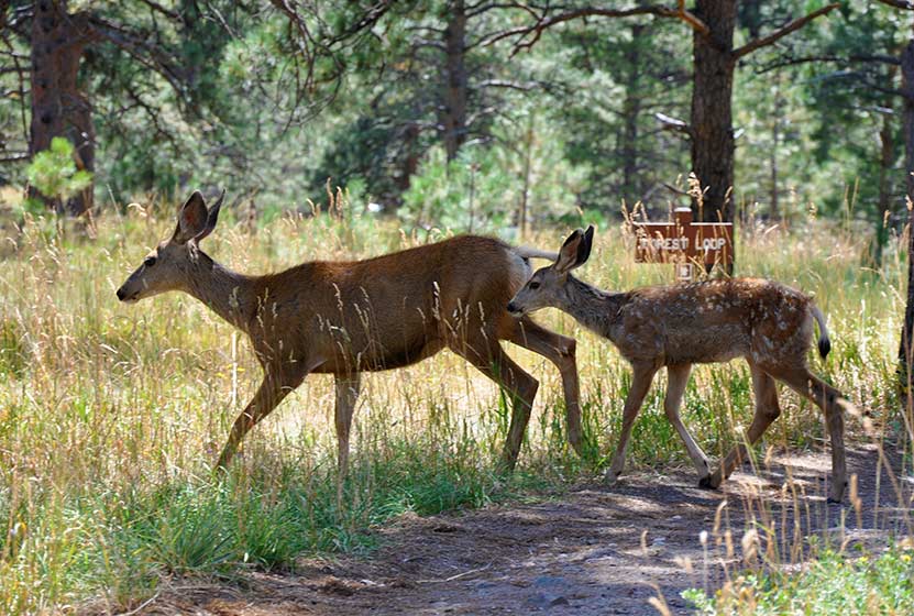
Meadow & Forest Loop Trails at Lookout Mountain Nature Center
If you are looking for a family hike near Denver, this is a perfect trail, especially if you are getting started hiking with your kids in Colorado and want to guarantee a good experience. It's short, there's wildlife, and the Lookout Mountain Nature Center. Take a picnic lunch, just watch out for the squirrels; they'll run of with your dessert if you don't watch them closely. Explore the full Meadow & Forest Loop Trails hike profile below for trail map, driving directions, and more tips and details to help you enjoy this family adventure.
| Hike Distance | 0.6 & 0.8 Mile Loops |
|---|---|
| Difficulty | Easy |
| Duration | Approx 30 min |
| Trail Type | Loop |
| Seasons | Hours Vary |
| Dogs | Not Allowed |
| Hike Trail Map | Click for a Map of Meadow & Forest Loop Trails at Lookout Mountain Nature Center |
| Denver Drive Time | 30 min |
| Driving Directions to Lookout Mountain Nature Center | Click for Google Map |
| Town Nearest Hike | Golden, Colorado |
| Beauty | Front Range views, ponderosa pine, wildlife: Abert's squirrels, and deer |
| Activities | Hiking, nature center, picnic area, birdwatching |
Lookout Mountain Nature Center has 2 short loop hikes. If you have young children, this is a perfect trip. The trails at Lookout Mountain are short loops: 1- The Meadow Loop (.8 mile) & 2 - Forest Loop Trail (.6 mile). If you are looking for a longer hike, you can cross the street and take the Lookout Mountain Trail which connects to several other Jefferson County Parks and trails.
The nature center is a great place for your kids to learn about Colorado wildlife. The playroom has texture sames of bark, fur, animal tracks, and the biggest box of stuffed animal puppets you'll ever see. The last time we visited, our daughter didn't want to leave. Take a lunch and have a picnic under the towering Ponderosa Pines. We encountered 2 deer with their fawns along the Forest Loop trail. The immediate area around the nature center is handicap accessible.
Tips & Resources for Hiking Meadow & Forest Loop Trails at Lookout Mountain Nature Center
- TIP: If you take Lookout Mountain Road from Golden, it's a beautiful drive. However, on the weekends, this road has a ton of cycling traffic. So, plan for a slow drive.
- TIP: Visit the Boettcher Mansion next door
- Trail Map for Lookout Mountain Nature Center: Trail Map Link
- Packing List: Always pack the 10 Essentials. Download our Hiking Guide to get the list and dayhiking packing checklist.
- Colorado Road Conditions: Colorado Road Conditions
- After the Hike: Louis’ Cafe
Weather
Map & Driving Directions
Click for Driving Directions
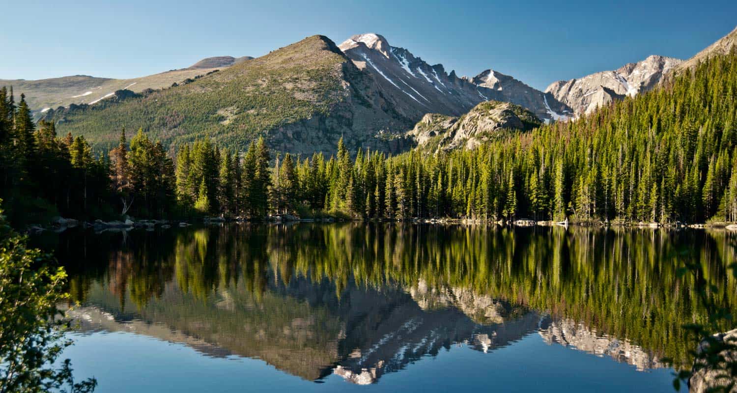
Bear Lake Hike at Rocky Mountain National Park
From Bear Lake in Rocky Mountain National Park (just 2 hours from Denver), you can launch out on dozens of hiking adventures, trails that range from less than a mile to full day treks back into Glacier Gorge or Andrews Creek. If you are visiting Colorado and looking for a high variety of trails or just a good place to start your vacation, this is one of the best places in the state. For details on the trail, see the hiking trail profile below, and download the trail map to get an idea of the different hikes that begin at Bear Lake.
Note: Rocky Mountain National Park now requires timed entry permits from May 27th through October 10th. See the RMNP permits page for more information.
Trail Snapshot: Bear Lake in Rocky Mountain National Park
| Hike Distance | 0.6 mile loop |
|---|---|
| Difficulty | Easy |
| Duration | Approx 30 min |
| Trail Type | Loop |
| Starting Elevation | 9475′ |
| Elevation Gain | +20′ |
| Seasons | Year Round |
| Dogs | Dogs Prohibited in RMNP |
| Hike Trail Map | Click for a Trail Map |
| Denver Drive Time | 2 hours |
| Driving Directions to Bear Lake Trailhead | Click for Google Map |
| Town Nearest Hike | Estes Park, Colorado |
| Beauty | Sub-Alpine Lake, Mountain Views, Wildlife: Abert's Squirrel, Elk, Bear |
| Activities | Picnicking, Snowshoeing, Hiking Trails |
| Conditions at Bear Lake Trailhead | Click Here |
| Fee | Park Pass Required |
Bear lake is the epicenter of Rocky Mountain National Park. This means that you can access a ton of trails from here, but it also means a lot of traffic. So, we always recommend getting there early, on weekdays, and to go during the off-season - if you can. The Bear Lake Trail is a short 0.6 mile loop around a beautiful lake with views of the Rocky Mountains. The hike is considered handicap accessible; however, the trail is not paved.
Tips & Resources for Hiking Bear Lake In Rocky Mountain National Park :
- For Disabled Visitors: Check out the Disabled Travelers' Companion Website for great info and pictures on more accessible trails in RMNP
- Check out: See our Handicap Accessible Hikes Page for more hikes as well
- Visiting Family & Friends: This is a great place to take visiting family and friends because it's not too difficult, and you have a lot of options if you want to explore the park
- Bring a Lunch: Getting this far into the park, even just driving, is quite a trip from the outside world. We suggest packing a lunch so that you can stay longer. And food just tastes better outside anyway.
- Trail Map for Rocky Mountain National Park: Trail Map Link
- Colorado Road Conditions: Colorado Road Conditions
- Photo Courtesy of Ben Grey.
- After the Hike: Poppy's Pizza
Weather
Map & Driving Directions
Click for Driving Directions
Crown Hill Lake Trails
Jefferson County seems to turn to gold about every park they touch here in Colorado. Crown Hill Lake Park is a prime example. It's an oasis in the midst of the busy city of Denver. The park has beautiful views of the Front Range mountains, including the Flatirons down in Boulder.
Crown Hill Lake Park has three miles of paved trails and .7 of them are considered ADA accessible, all in the heart of Denver. On the northwest side of the park, you'll find a wildlife sanctuary for migratory birds. Explore the full trail profile below for all the details: hiking trails, trail map, and detailed directions to the trailhead.
Trail Snapshot: Crown Hill Lake Trails
| Hike Distance | 1.2 miles+ |
|---|---|
| Difficulty | Easy |
| Duration | Approx 45mins+ |
| Trail Type | Loop |
| Seasons | All |
| Dogs | Allowed on Leash in Most Areas |
| Hike Trail Map | Click for a Map of Crown Hill Lake Trails |
| Denver Drive Time | 17 min |
| Driving Directions to Crown Hill Lake Trails | Click for Google Map |
| Town Nearest Hike | Lakewood, Colorado |
| Beauty | Lake, wildlife sanctuary, Front Range views, wildlife: ducks, geese |
| Activities | Horseback riding, cycling, fishing, hiking, picnic areas |
Hikes at Crown Hill Park:
- Loop Trail - 1.2miles - goes around the lakeside
- Perimeter Trail - 2 miles - goes around the edge of the park
- Nature Preserve Trail / Wildlife Sanctuary Trail - .7 mile - Hiker Only and ADA accessible trail
- Link to the Park's Map
Tips & Resources for Hiking Crown Hill Lake Trails :
- TIP: It's a busy park, so try earlier and later in the day.
- TIP: The wildlife preserve is hiker only. No dogs in this area.
- TIP: There is a lot of multi-use traffic on the trails, so be alert and yield when appropriate.
- Trail Map for Crown Hill Park: Trail Map Link
- Colorado Road Conditions: Colorado Road Conditions
- After the Hike: Danny's Carnation Restaurant
- Photo: We would like to express our gratitude to Kasey Cline for sharing such an amazing photograph of this hike.
Weather
Map & Driving Directions
Click for Driving Directions
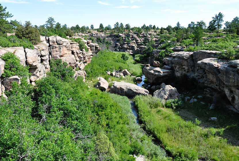
Canyon View Nature Trail at Castlewood Canyon
Castlewood Canyon cuts a unique and green landscape into the plains near Denver. It's not the mountains, but it's worth the drive. Castlewood Canyon State Park has created this beautiful paved trail that follows the canyon rim.
The Canyon Rim Trail also offers an audio tour and is a great way for children to learn more about the plains habitat that covers much of Colorado. Explore this full trail profile for driving directions, trail map, and all the details and tips you'll need to plan your trip to this Colorado State Park.
Trail Snapshot: Canyon View Nature Trail at Castlewood Canyon
| Hike Distance | 1.2 mi (2.4 mi RT) |
|---|---|
| Difficulty | Easy |
| Duration | Approx 1 hr or less |
| Trail Type | Out and Back |
| Seasons | All |
| Dogs | Allowed on Leash in Most Areas, But Not on the East Canyon Trail |
| Hike Trail Map | Click for a Map of Canyon View Nature Trail at Castlewood Canyon |
| Denver Drive Time | 50 min |
| Driving Directions to Canyon View Nature Trail at Castlewood Canyon | Click for Google Map |
| Town Nearest Hike | Castle Rock, Colorado |
| Beauty | Interesting geology, canyon views, interpretive trail, wildflowers, birdwatching |
| Activities | Guided audio nature tour, hiking, picnic areas, visitors center |
| Fee Required | Visit Colorado State Parks Site |
One of the best handicap accessible trails near Denver, the Canyon View Nature Trail at Castlewood Canyon State Park is a 1.2 mile interpretive trail. It runs along the western edge of the top of the canyon and weaves through ponderosa pine and a wonderful variety of wildflowers. The entire trail is a concrete walkway, making the area very accessible to wheelchairs. The trail ends at the Bridge Canyon overlook. Don't miss the view, it's wonderful.
Tips & Resources for Hiking Canyon View Nature Trail at Castlewood Canyon
- TIP: Pick up a brochure so that you can find the various access points for the trail and can take advantage of the side trails.
- Audio Tour: Begin at the visitor's center where you can pick up an audio tour player which guides you through the 5 different ecosystems that are found in Castlewood Canyon.
- Wildflowers: Late June and Early July are the best times to view the wildflowers in Castlewood Canyon.
- Bring Sunscren: Hikes in Castlewood Canyon can be quite exposed to the sun, so bring the sunscreen.
- TIP: Poison Ivy: We've been surprised how poison ivy flourishes in this park, often along the edge of the trail. Know how to identify it, so that you can avoid it. But don't let that deter you from the park. You just need to keep an eye out. See our post on how to identify and treat poison ivy.
- Trail Map for Castlewood Canyon: Trail Map Link
- Additional Maps: Castlewood Canyon State Park Trails
- Colorado Road Conditions: Colorado Road Conditions
- After the Hike: Crowfoot Valley Coffee
Weather
Map & Driving Directions
Click for Driving Directions
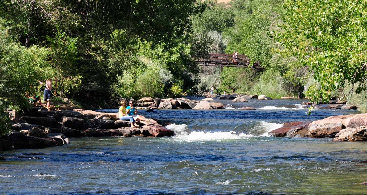
Clear Creek Trail in Downtown Golden
Want a hike to please everyone?The Clear Creek Trail in Golden, Colorado is it! It's got shade, the kids can bring their bikes, and you can finish your hike with a stroll around downtown. We might get some flack for calling this a hike, because it runs through the business district of Golden, CO.But you can wear the soles of your shoes down on this one. Jefferson County even has plans to expand the trail several miles into Clear Creek Canyon. Explore the full trail profile for all the details: hiking trails, trail map, and detailed directions to the trailhead.
Trail Snapshot:Clear Creek Trail in Downtown Golden
| Hike Distance | 1.8 Miles |
|---|---|
| Difficulty | Easy (super easy) |
| Duration | 1 hr |
| Trail Type | Out and Back |
| Seasons | All Season |
| Denver Drive Time | 30 min |
| Directions | Click for Google Map |
| Town Nearest Hike | Golden, Colorado |
| Beauty | Clear Creek, Cliff Swallows, Tree lined river |
| Activities | Parks, Shops, Kayaking, People Watching, Rollerblading, and Biking |
| Handicap Accessible | This Trail is Handicap Accessible |
When you have small children, some mornings can be harder than others to get through the foothills and into the mountains. This trail is made for those mornings. We like to park downtown, grab coffee at the Windy Saddle, then stroll down the trail. A local training school is often seen near the Washington Street Bridge doing water rescue training. It's highly entertaining and a great opportunity. Visiting family and friends will find this trail accessible, easy, and refreshing.
- Bring a Picnic and throw down a blanket at one of the several parks along the way (see map)
- You can start outside of town at the 6th Ave parking area and you have two options: Hike into town, or hike west in Clear Creek Canyon for .7 miles of the Grant Terry Trail
- Don't miss the cliff swallows that have built their nests along the 6th Ave. bridge.
- The Windy Saddle Cafe, on Washington Street offers a kids' playroom and their coffee is fantastic.
Tips & Resources for Hiking the Clear Creek Trail:
City of Golden Trail Map Link
City of Golden Open Space Map Link
Colorado Road Conditions
Weather
Map & Driving Directions
Click for Driving Directions
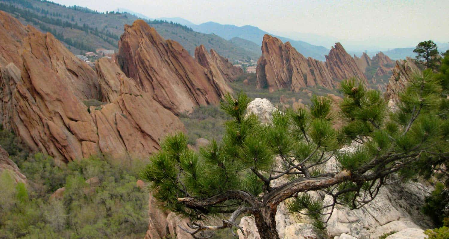
Fountain Valley Trail at Roxborough State Park
The Fountain Valley trail in Colorado's Roxborough State Park is the Garden of the God's of Denver. It's more secluded than Red Rocks park, and features several trails that take you beyond the park boundaries and into the foothills. The Fountain Valley Trail is a perfect place to start because it features the best part of the park, it's towering slabs of red rock. Explore the hiking profile below for all the trail details, trail map link, and driving directions to the trailhead for this easy Colorado hike.
Trail Snapshot: Fountain Valley Trail at Roxborough State Park
| Hike Distance | 2.3 miles |
|---|---|
| Difficulty | Easy |
| Duration | Approx 1.5 hr |
| Trail Type | Loop |
| Seasons | All Year |
| Dogs | Not Allowed in Roxborough State Park |
| Hike Trail Map | Click for a Map of Roxborough State Park |
| Denver Drive Time | 45 min |
| Driving Directions to Fountain Valley Trail at Roxborough State Park | Click for Google Map |
| Town Nearest Hike | Littleton, Colorado |
| Beauty | Red rock formations, meadows, wildlife: mule deer, eagles, foxes, birds |
| Activities | Hiking, birdwatching, Visitors' Center |
| Fee | Entrance Fee or State Parks Pass Required |
Roxborough State Park is Denver's twin sister of Garden of the God's in Colorado Springs. The beautiful Lyons and Fountain formations climb from the valley floor and create a wonderful space for a quiet hike, birdwatching, and viewing wildlife.
The trail is a loop. You can start on the valley floor, then work your way up to the high trail that looks down and across the fountain formation (photo above was taken from around the midpoint of the high trail). On our visit we encountered several whitetail deer and a variety of birds flitting about in the scrub oak that grows in the valley. The initial part of the trail are handicap accessible, but the trail soon becomes a more narrow dirt trail.
There are some ruins of an old estate along the trail and interpretive signs telling about the history of the valley. We would recommend this trail for families with small children and especially for folks visiting Denver and looking for something fun to do. The low elevation is great for out of towners who may not have the time or capacity to get up into the mountains. Dogs are not permitted, so be sure to leave fido at home. Because this trail is in Roxborough State Park, a fee or Colorado state parks pass is required. See the Roxborough State Park Fees page for details.
Tips & Resources for Hiking Fountain Valley Trail at Roxborough State Park :
- TIP: There is a picnic area with tables just outside the Visitors' Center.
- TIP: Be on the lookout for poison ivy along the sides of the trail. Know how to identify it, so that you can avoid it. But don’t let that deter you from the park. You just need to keep an eye out. See our post on how to identify and treat poison ivy.
- Trail Map for Roxborough State Park: Trail Map Link
- Colorado Road Conditions: Colorado Road Conditions
- After the Hike: Waterton Tavern in Roxborough
- Roxborough State Park Brochure
- Brochure for Roxborough State Park: Brochure Link
Weather
Map & Driving Directions
Click for Driving Directions