Blodgett Peak requires a challenging 3.2 mile ascent through the passage of rocky canyon to the summit where hikers gain panoramic views of Pikes Peak, Rampart Reservoir, and the United States Air Force Academy. Located on the northwestern edge of Colorado Springs, Blodgett Peak is a local favorite for those looking for demanding workout or just to enjoy the 360 degree views of the plains and mountains.
Trail Snapshot: Blodgett Peak
| Hike Distance | 6.4 miles Round Trip |
|---|---|
| Difficulty | Difficult |
| Duration | Approx 3 hrs |
| Trail Type | Out-And-Back |
| Starting Elevation | 7200′ |
| Elevation Gain | Approx +2680′ |
| Seasons | Year Round |
| Dogs | Allowed On Leash on Lower Trails |
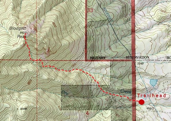
| Hike Trail Map | Click for Trail Map of Blodgett Peak Trail Map |
| Denver Drive Time | 1 hr 15 min |
| Driving Directions to Blodgett Peak Open Space Trailhead | Click for Google Map |
| Town Nearest Hike | Colorado Springs, Colorado |
| Beauty | Views of Pikes Peak, Rampart Range Reservoir, and the Air Force Academy, Cliff Bands, Seasonal Waterfall. |
| Activities | Hiking, Photography |
Parking & Trailhead Information for Blodgett Peak Open Space
From Denver, take Interstate 25 South and take Exit 149 onto Woodmen Road. Continue on West Woodmen Road until for 2.4 miles, then turn left onto Orchard Valley Road. Proceed for 1.1 mile, then turn right onto West Woodmen Road again (Yes, that’s the same West Woodmen road. It’s a curcuit, so it wraps around). The road will bend north, and after 0.8 mile you’ll see the Blodgett Peak Open Space on your left. It’s a small lot, and because this is a popular trail, it fills fast on the weekends. There is a portable restroom at the trailhead. The City of Colorado Springs is developing additional parking to the south.
The Hike: Blodgett Peak
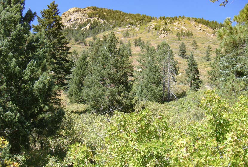
The trail up to Blodgett Peak begins on a wide, gravel road that heads west into the foothills and up toward a watertower built into the lower flanks of the mountainside. At just over a 1/2 mile, the trail encounters a double-track path named the Hummingbird Trail. Take the Hummingbird Trail until it ends at a broad gravel space near the entrace to the canyon. The correct trail up to Blodgett Peak will be on your left. Avoid other social trails and take this more established route up into the canyon.
You’ll know that you are on the right trail when, just a little ways up the trail, you see a large boulder. Here is where the trail becomes more steep and demanding. As always, it’s important to stay the trail to reduce human impact, especially the erosion that can quickly damage the scree surface and drainage ecosystem of this area. The upper regions of the Blodgett Peak trail were impacted by the 2012 Waldo Canyon fire and are going to take many years to reestablish, making it that much more critical that hikers stay the trail.
This trail segment continues for about a mile then, at 2.3 miles encounters an intermittent waterfall on the left side fo teh trail. Depending on rain and snowmelt, Blodgett Falls may be dried up or a quaint but beautiful spill over about 50′ of granite cliffs. Just before the waterfall, the trail up Blodgett will bear to the right taking hikers between cliffs and the boulder field.
Again, stay the trail here as you enter a wooded section (which bears to the left or to the west of the boulder field) because the boulder field has a lot of loose rock and it would be easy to inadvertently trundle rock down onto hikers below. Good friends had this happen to them on this hike several years ago.
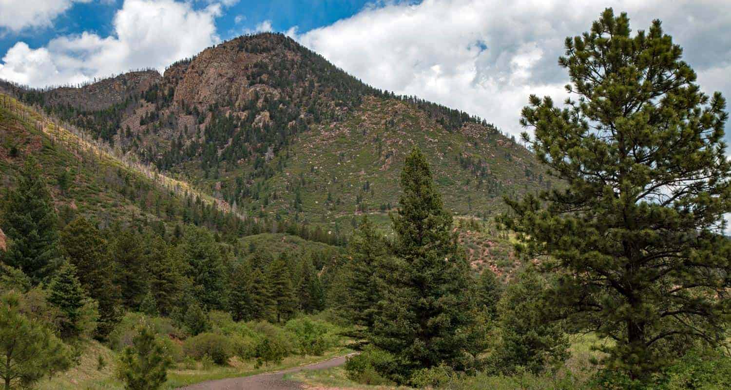
Next, the trail crosses the intermittent stream bed again and bends to the north, where hikers will notice the scars and deadfall from the Waldo Canyon fire. Be aware that this segment has many dead trees and snags that can be toppled by the winds that run up through the canyon. The trail continues to be steep and demanding with a wall of cliffs on the left side.

At 3 miles, the trail emerges from the steep canyon onto the broad southern saddle of Blodgett Peak. Keep alert because, this last segment of the trail along the saddle to the summit it littered with more deadfall and snags.
At the summit of Blodgett Peak, you’ll to take in great views of Pikes Peak to the South, and Rampart Range Reservoir to the west. The Air Force Academy will be below you to the Northeast and Colorado Springs spreads itself out across the eastern plains.
Hike back down the way you came for a total hike distance of about 6.4 miles. Avoid alternative routes down the mountain as these can lead to being cliffed out or cause more damage to a landscape that’s in need in of our care.
Tips & Resources for Hiking Blodgett Peak
- Not Dog Friendly: Dogs are allowed on the lower trails at Blodgett Peak Open Space, but due to the terrain, narrow trail sections, this hike up the peak is not considere a dog-friendly hike.
- Trekking Poles and Traction: At Blodgett Peak hikers will encounter a lot of steep terrain and scree. In the winter months, the trail can get icy and muddy in spots. Because of this, we recommend Trekking Poles. During the winter season, it’s a hike that may require traction devices. I’m a huge fan of trekking poles because they take so much impact off the knees when hiking and backpacking, and allow us to navigate more demanding terrain. Check out Trekking Pole options at REI.
- Packing List: Always pack the 10 Essentials. Download our Hiking Guide to get the list and dayhiking packing checklist.
- Colorado Road Conditions: Colorado Road Conditions
- Photo: We would like to express our gratitude to Joel Tonyan and Tim Marshallfor sharing such an amazing photographs of Blodgett Peak.
- After the Hike: Check out Arlene’s Beans and Salsa in Monument.. If you are looking for a local brew, drop by Pikes Peak Brewing Company, also in Monument.
Weather
Map & Driving Directions
Click for Driving Directions


