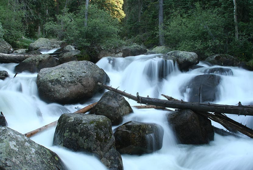
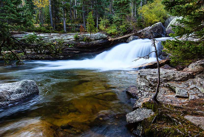
Calypso Cascades in Rocky Mountain National Park
Calypso Cascades is an easy 3.6 mile hike to one of several waterfall destinations along this section of trail. This waterfall in the Wild Basin of Rocky Mountain National Park is gets its name from the purple Calypso Orchids that bloom along the banks of Cony Creek. Explore the full Calypso Cascades hike profile below for trail map, driving directions, and more tips and details to help you enjoy this adventure in Rocky Mountain National Park.
Note: Rocky Mountain National Park now requires timed entry permits from May 27th through October 10th. See the RMNP permits page for more information.
Trail Snapshot: Calypso Cascades in Rocky Mountain National Park
| Hike Distance | 3.6 miles Round Trip |
|---|---|
| Difficulty | Easy |
| Duration | 2-3 hr Round Trip |
| Trail Type | Out and Back |
| Starting Elevation | 8566' |
| Elevation Gain | Approx. +700' |
| Seasons | Spring through Fall, Winter Snowshoeing |
| Dogs | Prohibited in RMNP |
| Hike Trail Map | Click for a Map of Calypso Cascades RMNP |
| Denver Drive Time | 1 hr 30 min |
| Driving Directions to Wild Basin Trailhead | Click for Google Map |
| Driving Directions to Winter Recreation Parking for Wild Basin Hikes | Click for Google Map |
| Town Nearest Hike | Allenspark, Colorado |
| Beauty | Waterfall, mountain views, meadows, river, wildlife: Abert's squirrel, elk, deer, moose, bear; wildflowers |
| Activities | Picnicking, hiking trails, snowshoeing, horseback riding, backcountry camping (with a permit), photography |
| Fee | Park Pass Required |
Parking & Trailhead Information for Calypso Cascades
The southeast corner of Rocky Mountain National Park boasts one of the loveliest portions in the park known as the Wild Basin. The Wild Basin Trailhead is located just 15 minutes outside of Allenspark, Colorado along Highway 115. There is a ranger station at at the Wild Basin Trailhead with toilets and drinking water available.
In the winter (October-May), Hwy 115 may not be plowed to the trailhead, and hikers will need to park their vehicles at a winter parking lot for Wild Basin hikes. Be aware that hikes from the winter parking lot add on another 3 miles of hiking (one-way). There are other small parking areas, like the Finch Lake Trailhead, that may be accessible and allow hikers to park closer to the Wild Basin Trailhead. It's important to know that Hwy 115, though titled a "highway", is a maintained dirt road, which means that it can be used by 2WD vehicles. However, after heavy rains and other severe weather, its quality may degrade until it is repaired. 4WD may be needed when snow is on the ground.
Calypso Cascades From Below
The Hike: Calypso Cascades Trail in RMNP
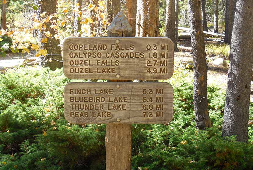
The hike to Calypso Cascades begins at the Wild Basin Trailhead, and at just .3 mile into the trail, passes by both the lower and upper leaps of Copeland Falls. Read our full trail profile on Copeland Falls for details on how to access both sets of cascades.
After taking in the views at Copeland Falls, the trail follows the course of North St. Vrain Creek as it flows out of the rugged high country and snowfields in this wild corner of Rocky Mountain National Park. Soon the trail will split. The right-hand trail leads through a segment of trail with 5 different backcountry camping sites and on towards Thunder and Lion lakes. These backcountry camping sites can be reserved through the RMNP Backcountry Offices. The left-hand trail leads south towards Calypso Cascades and Finch Lake Trail system.
Taking the Finch Lake Trail, hikers will cross a large log bridge spanning North St. Vrain Creek. Near the bridge, you'll discover an unnamed set of cascades. After crossing the bridge, the trail follows Cony Creek for about 0.4 mile to the site of Calypso Cascades. Calypso Cascades are reminiscent of Fern Falls: the waters of Cony Creek tumble over boulders and fallen trees in a moss-covered landscape. What makes Calypso Cascades unique are the Calypso Orchids (also known as Pink Lady Slippers) that bloom in the late-spring and early-summer along the creek.
Hikers can return to the trailhead to make this a 3.6 mile hike, or can continue on the Finch Lake trail for approximately 1 mile to the site of Ouzel Falls.
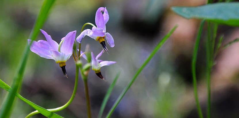
Pink Fairy Slipper Flower

Tips & Resources for Hiking to Calypso Cascades in RMNP
- TIP: The area near the bridge over North St. Vrain Creek can be a great spot for a picnic.
- Packing List: Always pack the 10 Essentials. Download our Hiking Guide to get list and dayhiking packing checklist.
- TIP: There are food storage lockers available at the Wild Basin, Finch Lake, and Sandbeach Lake Trailheads. These are required for visitors staying overnight.
- Get there early: Parking lot might get full even early in the morning.
- You're in Bear Country: Black Bears live in the Wild Basin area and are active on the months of April through November. Be aware, dispose of your food responsibly, and don't food or anything else with a strong scent in your vehicle.
- Trail Map for Wild Basin Area: Trail Map Link
- Colorado Road Conditions: Colorado Road Conditions
- Photo: We would like to express our gratitude to Jeff Kramer for sharing such an amazing photograph of this hike to Calypso Cascades in RMNP.
- After the Hike: Meadow Mountain Cafe
Weather
Map & Driving Directions
Click for Driving Directions

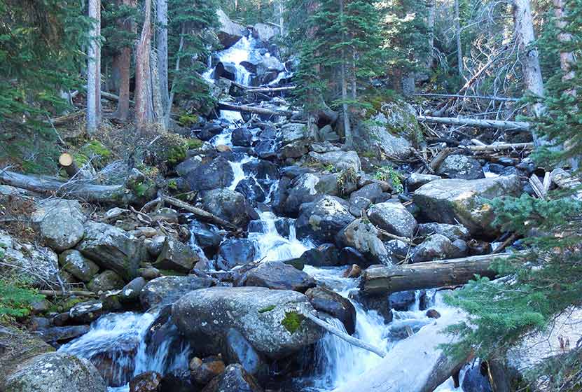
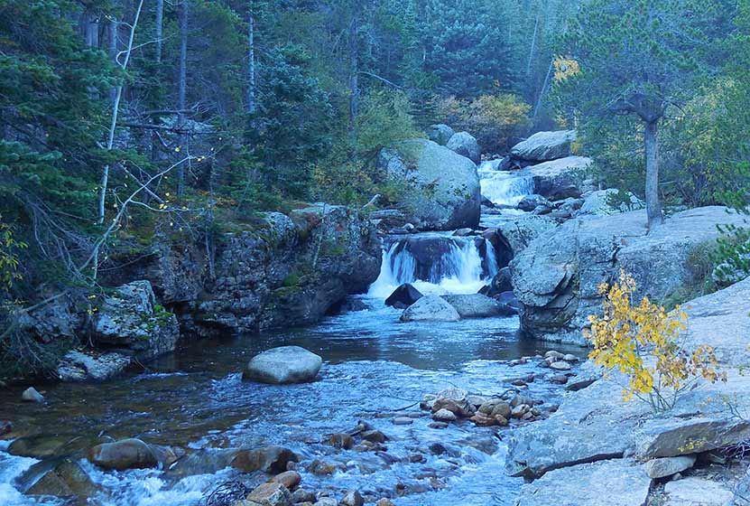
Ouzel Falls in Rocky Mountain National Park
Ouzel Falls spills over a cliffside and enormous boulders, making it arguably one of the most beautiful waterfalls in Rocky Mountain National Park. Before reaching this 40-foot falls, the trail traces the course of several creeks and leads hikers past three other cascade waterfalls. Explore the full Ouzel Falls hike profile below for trail map, driving directions, and more tips and details to help you enjoy this adventure in the Wild Basin of Rocky Mountain National Park.
Note: Rocky Mountain National Park now requires timed entry permits from May 27th through October 10th. See the RMNP permits page for more information.
Trail Snapshot: Ouzel Falls in Rocky Mountain National Park
| Hike Distance | 5.4 miles Round Trip |
|---|---|
| Difficulty | Moderate |
| Duration | 3 - 4 hr Round Trip |
| Trail Type | Out and Back |
| Starting Elevation | 8566' |
| Elevation Gain | Approx +950' |
| Seasons | Spring through Fall, Winter Snowshoeing |
| Dogs | Prohibited in RMNP |
| Hike Trail Map | Click for a Map of Ouzel Falls RMNP |
| Denver Drive Time | 1 hr 30 min |
| Driving Directions to Wild Basin Trailhead | Click for Google Map |
| Driving Directions to Winter Recreation Parking for Wild Basin Hikes | Click for Google Map |
| Town Nearest Hike | Allenspark, Colorado |
| Beauty | Waterfall, mountain views, meadows, river, wildlife: Abert's squirrel, elk, deer, moose, bear; wildflowers |
| Activities | Picnicking, hiking trails, snowshoeing, horseback riding, backcountry camping (with a permit), photography |
| Fee | Park Pass Required |
Parking & Trailhead Information for Ouzel Falls
The southeast corner of Rocky Mountain National Park boasts one of the loveliest portions in the park known as the Wild Basin. The Wild Basin Trailhead is located just 15 minutes outside of Allenspark, Colorado along Highway 115. There is a ranger station at at the Wild Basin Trailhead with toilets and drinking water available.
In the winter (October-May), Hwy 115 may not be plowed to the trailhead, and hikers will need to park their vehicles at a winter parking lot for Wild Basin hikes. Be aware that hikes from the winter parking lot add on another 3 miles of hiking (one-way). There are other small parking areas, like the Finch Lake Trailhead, that may be accessible and allow hikers to park closer to the Wild Basin Trailhead. It's important to know that Hwy 115, though titled a "highway", is a maintained dirt road, which means that it can be used by 2WD vehicles. However, after heavy rains and other severe weather, its quality may degrade until it is repaired. 4WD may be needed when snow is on the ground.
The Hike: Ouzel Falls Trail in RMNP
This 2.7 mile hike (one-way) begins at the Wild Basin Trailhead and passes three other cascade waterfalls before arriving at the Ouzel Falls. Copeland Falls are found just 0.4 miles into the hike. For details on locating both the lower and upper cascades, explore our full trail profile on Copeland Falls. After Copeland Falls, the trail continues following alongside North Saint Vrain Creek for about 1 mile to where it splits. The right-hand trail leads south to a log bridge crossing the creek. Near the bridge, hikers can take in the sights and sounds of another small cascade.
The trail continues south to Calypso Cascades, the third and final cascade waterfall before reaching Ouzel Falls. Here the trail splits again. The left-hand/east trail leads aback towards the Finch Lake trail and the Allenspark Trailhead. The right-hand/west trail leads towards Ouzel Falls and the Bluebird Lake Trail. Here, the trail crosses a set of two bridges, then climbs uphill through a set of switchbacks. The mountains to the north now come into view, both Mt. Meeker, Pagoda, and Longs Peak. This segment of trail between Calypso Cascades and Ouzel Falls is approximately 1 mile.
A second set of switchbacks brings hikers within earshot of the falls, and they will come into view at the bridge that crosses over Ouzel Creek. However, the best views of the falls can be gained via a social trail that is located before the bridge on the left side of the creek. This unmaintained trail leads to an area above the falls with incredible views of alpine meadows and craggy peaks. As with any social trails, please use the most worn paths and hike on durable surfaces. Be aware that the rock can become slick in this area and hikers should exercise caution when navigating above the falls.
Ouzel Falls is named after the Ouzel or Water-Dipper, the only songbird that lives a mostly aquatic life. Ouzels weave globe-shaped nests near waterfalls, lakes, and streams. They dive--even walk--underwater to catch insects and larvae.
Hikers can return the 2.7 miles back they way they came to Ouzel Falls, or can hike further to destinations such as Ouzel Lake (an additional 2.2 miles, one-way).
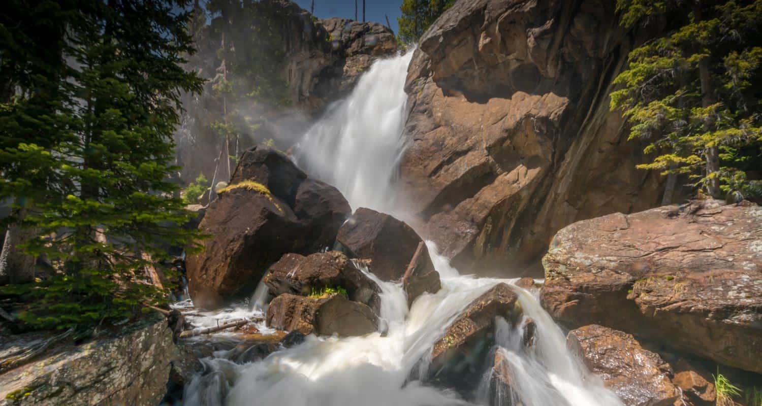
Ouzel Falls on a Wet Spring Day - Courtesy of Chris Heald

Tips & Resources for Hiking to Ouzel Falls in RMNP
- Get there early: Parking may be somewhat limited as with many hikes in RMNP. Parking at the trailhead can fill up, even in the early morning.
- You're in Bear Country: Black Bears live in the Wild Basin area and are active on the months of April through November. Be aware, and dispose of your food responsibly. Be sure that no food or strong scented items are left in your car.
- TIP: There are food storage lockers available at the Wild Basin, Finch Lake, and Sandbeach Lake Trailheads. These are required for visitors staying overnight.
- Trail Map for Wild Basin Area: Trail Map Link
- Packing List: Always pack the 10 Essentials. Download our Hiking Guide to get list and dayhiking packing checklist.
- Colorado Road Conditions: Colorado Road Conditions
- Photo: We would like to express our gratitude to Steven Bratman for sharing such an amazing photograph of this hike to Ouzel Falls in RMNP.
- After the Hike: Meadow Mountain Cafe
Weather
Map & Driving Directions
Click for Driving Directions

Copeland Falls in Rocky Mountain National Park
Copeland Falls is just one of the many waterfalls hikers will encounter in the Wild Basin area of Rocky Mountain National Park. In fact, you can't miss Copeland Falls as it is the first waterfall along the main trail--just a short hike from the trailhead. Explore the full Copeland Falls hike profile below for trail map, driving directions, and more tips and details to help you enjoy this adventure in Rocky Mountain National Park.
Note: Rocky Mountain National Park now requires timed entry permits from May 27th through October 10th. See the RMNP permits page for more information.
Trail Snapshot: Copeland Falls in Rocky Mountain National Park
| Hike Distance | 0.6 miles Round Trip |
|---|---|
| Difficulty | Easy |
| Duration | Less than 1 hr Round Trip |
| Trail Type | Out and Back |
| Starting Elevation | 8566' |
| Elevation Gain | Approx. +15' |
| Seasons | Spring through Fall, Winter Snowshoeing |
| Dogs | Prohibited in RMNP |
| Hike Trail Map | Click for a Trail Map |
| Denver Drive Time | 1 hr 30 min |
| Driving Directions to Wild Basin Trailhead | Click for Google Map |
| Driving Directions to Winter Recreation Parking for Wild Basin Hikes | Click for Google Map |
| Town Nearest Hike | Allenspark, Colorado |
| Beauty | Waterfall, mountain views, meadows, river, wildlife: Abert's squirrel, elk, deer, moose, bear; wildflowers |
| Activities | Picnicking, hiking trails, snowshoeing, horseback riding, backcountry camping (with a permit), photography |
| Fee | Park Pass Required |
Another View of Copeland Falls
Parking & Trailhead Information for Copeland Falls
The southeast corner of Rocky Mountain National Park boasts one of the loveliest portions in the park known as the Wild Basin. The Wild Basin Trailhead is located just 15 minutes outside of Allenspark, Colorado along Highway 115. There is a ranger station at at the Wild Basin Trailhead with toilets and drinking water available.
In the winter (October-May), Hwy 115 may not be plowed to the trailhead, and hikers will need to park their vehicles at a winter parking lot for Wild Basin hikes. Be aware that hikes from the winter parking lot add on another 3 miles of hiking (one-way). There are other small parking areas, like the Finch Lake Trailhead, that may be accessible and allow hikers to park closer to the Wild Basin Trailhead. It's important to know that Hwy 115, though titled a "highway", is a maintained dirt road, which means that it can be used by 2WD vehicles. However, after heavy rains and other severe weather, its quality may degrade until it is repaired. 4WD may be needed when snow is on the ground.
Wild Basin Trailhead
The Hike: Copeland Falls Trail in RMNP
Copeland Falls is just a short and easy hike from the Wild Basin Trailhead. There are lower and upper leaps at Copeland Falls, and they are reached by following a couple of spur trails that branch off from the main trail. Signs will indicate the location of the trail to the Lower Copeland Falls. After viewing the lower falls, another spur trail leads along St. Vrain Creek to Upper Copeland Falls. A sign will indicate where this second spur trail is located. After viewing the falls, hikers can connect back to the main Wild Basin Trail which leads on to many other beautiful destinations, including several more waterfalls.
Tips & Resources for Hiking to Copeland Falls in RMNP
- TIP: Bring lots of water and high-energy food.
- TIP: There are food storage lockers available at the Wild Basin, Finch Lake, and Sandbeach Lake Trailheads. These are required for visitors staying overnight.
- Get there early: Parking lot might get full even early in the morning.
- You're in Bear Country: Black Bears live in the Wild Basin area and are active on the months of April through November. Be aware, and dispose of your food responsibly.
- Trail Map for Wild Basin Area: Trail Map Link
- Packing List: Always pack the 10 Essentials. Download our Hiking Guide to get list and dayhiking packing checklist.
- Colorado Road Conditions: Colorado Road Conditions
- Photo: We would like to express our gratitude to Ben Graham for sharing such an amazing photograph of this hike to Copeland Falls in RMNP. His photos can also be seen at Redbubble.
- After the Hike: Meadow Mountain Cafe
Weather
Map & Driving Directions
Click for Driving Directions