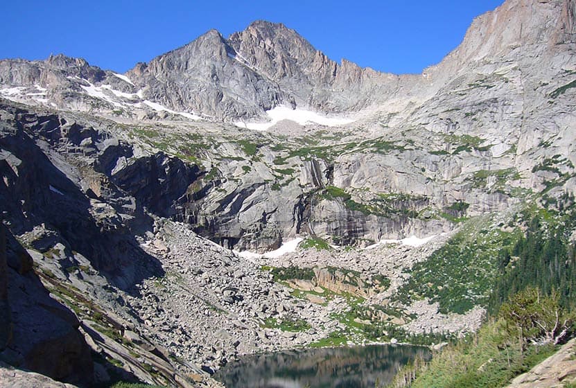
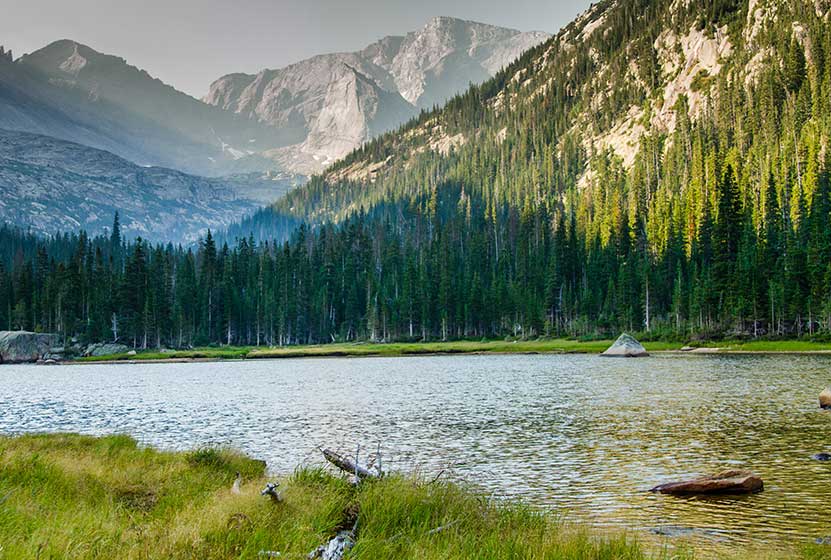
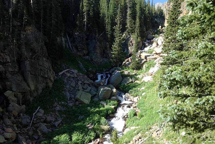
Black Lake Falls in Rocky Mountain National Park
Black Lake Falls cascades down the towering granite cliffs above Black Lake in Rocky Mountain National Park. This trail through Glacier Gorge takes hikers past multiple sub-alpine lakes and several waterfalls. It's a demanding, 10 mile, round-trip hike with significant elevation gain in the heart of RMNP.
Note: Rocky Mountain National Park now requires timed entry permits from May 27th through October 10th. See the RMNP permits page for more information.
Trail Snapshot: Black Lake Falls in Rocky Mountain National Park
| Hike Distance | 10 mile Round Trip |
|---|---|
| Difficulty | Difficult |
| Duration | Approx 6 hrs Round Trip |
| Trail Type | Out and Back |
| Starting Elevation | 9240' at Trailhead |
| Elevation Gain | +1430′ |
| Seasons | May-September |
| Dogs | Prohibited in RMNP |
| Hike Trail Map | Click for a Trail Map |
| Denver Drive Time | 2 hr |
| Driving Directions to Glacier Gorge Trailhead | Click for Google Map |
| Town Nearest Hike | Estes Park, Colorado |
| Beauty | Waterfalls, wildlife: elk, deer, marmots; meadows, lakes, streams, wildflowers, aspen trees |
| Activities | Hiking, photography, fishing |
| Fee | Park Pass Required |
Black Lake Falls is located on the cliffside above the western edges of Black Lake and is best viewed from the boulder strewn shores of Black Lake. In the photo above, you'll be able to distinguish the stream of the falls cascading over grey granite cliffs. For a detailed description of this journey to Black Lake Falls, explore our full trail profile on Black Lake. Below you'll find a list of some of the other destinations in the Glacier Gorge trail system.
List and Links of Destinations From Glacier Gorge Trailhead to Black Lake
1. Glacier Gorge Trailhead
2. Alberta Falls - @ .8 mile
3. Mills Lake - @ 2.8 miles
4. Jewel Lake - @ 3.2 miles
5. Ribbon Falls - @ 4.8 miles
6. Black Lake - @ 5 miles

Tips & Resources for Hiking Black Lake Falls in Glacier Gorge RMNP :
- Start Early: The hike to Black Lake and Black Lake Falls is challenging and hikers will want to begin early to avoid being in this exposed area when afternoon thunderstorms often tear through the area in Summer.
- Trekking Poles in Spring and Winter: Because the trail is high in the mountains, the snow and ice can hang around into late Spring and even early Summer, then pick up again in the Fall. Because of this, we recommend Trekking Poles and/or Traction Devices for this trail when the trail conditions are such.
- Parking: If the parking lot is full at Glacier Gorge Trailhead, there is a shuttle available to take you to the trailhead, or you can park at the Bear Lake Trailhead.
- Rocky Mountain National Park Trail Conditions: Click for RMNP Trail Conditions
- Trail Map for Bear Lake Corridor Trails: Trail Map Link
- Rain Gear Recommended: On every occasion I've been into Glacier Gorge, it's been gorgeous weather--and it rained. So, bring Rain gear. In the summer months, thunderstorms can form quickly in this area, especially in the afternoon--just another reason to begin your hike early.
- Packing List: Always pack the 10 Essentials. Download our Hiking Guide to get list and dayhiking packing checklist.
- Colorado Road Conditions: Colorado Road Conditions
- After the Hike: Inkwell Brew Coffee
- Photo: We would like to express our gratitude to Martin Braveboer for sharing such an amazing photograph of Black Lake and Black Lake Falls.
Weather
Map & Driving Directions
Click for Driving Directions

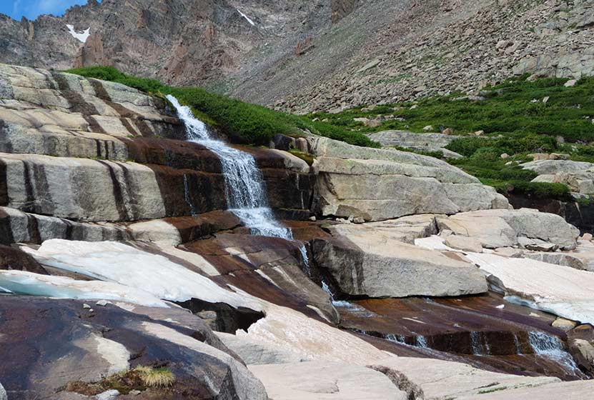
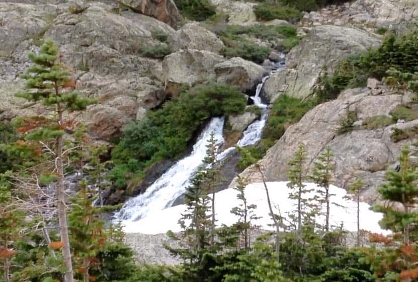
Shelf Lake Falls in Rocky Mountain National Park
You won't find the cascades of Shelf Lake Falls on the map. This tiered, shelf waterfall is hidden away in the high country above Glacier Gorge in Rocky Mountain National Park. Shelf Lake Falls flows out of Solitude Lake then into a creek that spills over the rock shelves of the falls, cutting strange formations out of the snow and ice that often remain into late Summer.
Note: Rocky Mountain National Park now requires timed entry permits from May 27th through October 10th. See the RMNP permits page for more information.
Trail Snapshot: Shelf Lake Falls in Rocky Mountain National Park
| Hike Distance | 8.5 miles Round Trip |
|---|---|
| Difficulty | Difficult |
| Duration | Approx 5-7 hrs Round Trip |
| Trail Type | Out and Back |
| Starting Elevation at Glacier Gorge Trailhead | 9240′ |
| Elevation Gain | Approx +2350′ |
| Seasons | Mid-Summer-September |
| Dogs | Prohibited in RMNP |
| Hike Trail Map | National Geographic Trails Illustrated Map |
| Denver Drive Time | 2 hr |
| Driving Directions to Glacier Gorge Trailhead | Click for Google Map |
| Town Nearest Hike | Estes Park, Colorado |
| Beauty | Waterfalls, wildlife: elk, deer, marmots; meadows, lakes, streams, wildflowers |
| Activities | Hiking, photography, fishing |
| Fee | Park Pass Required |
The journey to Shelf Lake and Shelf Lake Falls follows an out-of-the-way, unmaintained trail, and is a very demanding hike. The hike is best suited for those who have experience navigating off-trail in the backcountry. Because this is a destination page, it does not include trail details. See the Shelf Lake Trail profile for a more detailed description and photos of this hike into the high country of Rocky Mountain National Park.
Tips & Resources for Hiking to Shelf Lake Falls in Glacier Gorge RMNP
- Start Very Early: Because this hike is so demanding, and because thunderstorms jet through Glacier Gorge on many summer days, it's wise to begin the journey early in the morning.
- Parking: If the parking lot is full at Glacier Gorge Trailhead, there is a shuttle available to take you to the trailhead, or you can park at the Bear Lake Trailhead.
- Bring Food: My legs were shot after hiking back to the main trail, and my energy was waning. I had packed a few snacks, but wish I had packed more. So, bring something to give you an energy boost for your hike back to the Glacier Gorge Trailhead.
- Trekking Poles: Trekking poles proved really helpful, especially in navigating the descent.
- Recommended Map for Rocky Mountain National Park: The trail maps provided by Rocky Mountain National Park are usually sufficient. However, if you plan to hike RMNP often, we recommend purchasing a National Geographic Trails Illustrated Map.
- Packing List: Always pack the 10 Essentials. Download our Hiking Guide to get list and dayhiking packing checklist.
- Colorado Road Conditions: Colorado Road Conditions
- After the Hike: Inkwell & Brew Coffee
Weather
Map & Driving Directions
Click for Driving Directions
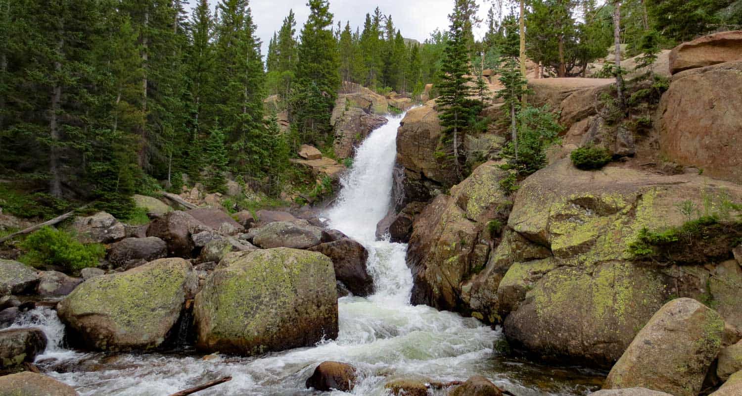
Ribbon Falls Hike in Rocky Mountain National Park
Ribbons Falls is a slide waterfall that spills from Black Lake in Rocky Mountain National Park. The 4.8 mile hike up to Ribbon Falls is demanding, but well worth the effort as you'll encounter several other waterfalls along the way. Push an additional .2 mile up the trail to Black Lake and yet another waterfall, Black Lake Falls, that seasonally pours down from the heights above Black Lake. Explore the full Ribbon Falls hiking trail profile for trail map, driving directions, and all the details you need to enjoy this adventure in Rocky Mountain National Park.
Note: Rocky Mountain National Park now requires timed entry permits from May 27th through October 10th. See the RMNP permits page for more information.
Trail Snapshot: Ribbon Falls in Rocky Mountain National Park
| Hike Distance | 9.6 miles Round Trip |
|---|---|
| Difficulty | Difficult |
| Duration | Approx 5-6 hrs Round Trip |
| Trail Type | Out and Back |
| Starting Elevation | 9240' at Trailhead |
| Elevation Gain | Approx +1400′ |
| Seasons | May-September |
| Dogs | Prohibited in RMNP |
| Hike Trail Map | Click for a Map of Ribbon Falls in Glacier Gorge |
| Denver Drive Time | 2 hr |
| Driving Directions to Glacier Gorge Trailhead | Click for Google Map |
| Town Nearest Hike | Estes Park, Colorado |
| Beauty | Waterfall, wildlife: elk, deer, marmots; meadows, lakes, streams, wildflowers, aspen trees |
| Activities | Hiking, photography |
| Fee | Park Pass Required |
Parking & Trailhead Information for Ribbon Falls RMNP, Colorado
The trail to Ribbon Fall begins at either the Glacier Gorge Trailhead (see driving directions above), or at the Bear Lake Trailhead (driving directions). Because the Glacier Gorge Trailhead has more limited parking, you may need to drive further up to Bear Lake. There you'll find a short connector trail that will put you on the path to the Glacier Gorge Trail system. In the event that parking at Bear Lake is full, you'll then need to park at the Park & Ride near the Bierstadt Trailhead and take the bus into the trailhead. This service runs 7am to 7PM and more information on the RMNP shuttle bus routes can be found at this link.
The Hike to Ribbon Falls, RMNP
Hiking to Ribbon Falls takes you into the Glacier Gorge Trail system with many wonderful destinations including Mills Lake, Jewel Lake, and further to Black Lake. Review the different waypoints and destinations below so that you don't miss any of the sites. The first destination is at .8 miles, Alberta Falls. After Alberta Falls, the trail ascends toward an eventual trail junction. The way to Ribbon Falls is to follow the Glacier Gorge/Loch Vale trail that bears right. This trail climbs steadily for about another half mile until arriving at a second major trail junction with three options. The left-hand trail leads into Glacier Gorge and eventually up to Ribbon Falls.
List and Links of Destinations From Glacier Gorge Trailhead to Black Lake
1. Glacier Gorge Trailhead
2. Alberta Falls - @ .8 mile
3. Mills Lake - @ 2.8 miles
4. Jewel Lake - @ 3.2 miles
5. Ribbon Falls - @ 4.8 miles
6. Black Lake - @ 5 miles
Jewel Lake - On the Way to Ribbon Falls - Photo Courtesy of J. Gemplar
At Mills Lake, the trail skirts its eastern shore for about half a mile until arriving at Jewel Lake, a much smaller body of water surrounded by lush green marshes. The next segment of the trail is my favorite, a challenging stretch of approximately 2 miles that leads hikers across bogs, and through verdant forest where the snow hangs on well into the summer months. In fact, this stretch may prove very difficult in the spring and early weeks of June--depending on that year's weather. The trail continues to follow Glacier Creek up into the higher reaches of the gorge and ever closer to Keyboard of the Winds, the jagged rock formation ever present against the eastern sky.
Ribbon Falls is located just below Black Lake, on the right-hand side of the trail. It's classified as a slide waterfall. This is just like it sounds: glacier creek flows over a long stretch of orange and pink granite, creating a splash of sound that beckons hikers to stop and take in the view. While it's not the most impressive of waterfalls in Rocky Mountain National Park, it feels like discovering a treasure hidden up in these heights where fewer people choose to go.
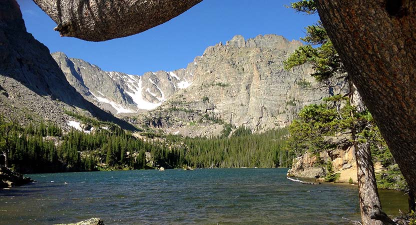
From here, you can sit and take in the views, or continue up the trail .2 mile to Black Lake. It may require some careful bouldering to make it over the fortress of rock that holds this high mountain lake. Above Black Lake is another small lake, Frozen Lake, that is hidden from view. In the early weeks of Summer and after rains, a waterfall spills out of Frozen Lake, cascading over the grey rock in a tiered waterfall and eventually making its way into Black Lake.

Tips & Resources for Hiking Ribbon Falls in Glacier Gorge RMNP :
- Start Early: The hike to Ribbon Falls is challenging and hikers will want to begin early to avoid being in this exposed area when afternoon thunderstorms often tear through the area in Summer.
- Trekking Poles in Spring and Winter: Because the trail is high in the mountains, the snow and ice can hang around into late Spring and even early Summer, then pick up again in the Fall. Because of this, we recommend Trekking Poles and/or Traction Devices for this trail when the trail conditions are such.
- Parking: If the parking lot is full at Glacier Gorge Trailhead, there is a shuttle available to take you to the trailhead, or you can park at the Bear Lake Trailhead.
- Rocky Mountain National Park Trail Conditions: Click for RMNP Trail Conditions
- Trail Map for Bear Lake Corridor: Trail Map Link
- Rain Gear Recommended: On every occasion I've been into Glacier Gorge, it's been gorgeous weather--and it rained. So, bring rain gear. In the summer months, thunderstorms can form quickly in this area, especially in the afternoon.
- Packing List: Always pack the 10 Essentials. Download our Hiking Guide to get list and dayhiking packing checklist.
- Colorado Road Conditions: Colorado Road Conditions
- Photo: We would like to express our gratitude to Thomas Mangan for sharing such an amazing photograph of this hike.
- After the Hike: Inkwell Brew Coffee
Weather
Map & Driving Directions
Click for Driving Directions
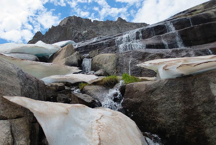
Lake of Glass Waterfall in Rocky Mountain National Park
If you are up for a demanding hike in Rocky Mountain national Park, with 3 waterfalls in the space of less than 5 miles, then the hike up to Lake of Glass Falls is a great choice.
A hidden waterfall that you won't find on the map! Lake of Glass falls is a segmented cascade spilling into the creek that soon becomes Timberline Falls. This relatively demanding hike in Rocky Mountain National Park begins at the Glacier Gorge trailhead, and takes you past two larger waterfalls on your 4.2 mile journey to Lake of Glass Falls.
Note: Rocky Mountain National Park now requires timed entry permits from May 27th through October 10th. See the RMNP permits page for more information.
Trail Snapshot: Lake of Glass Falls in Rocky Mountain National Park
| Hike Distance | 8.4 miles Round Trip |
|---|---|
| Difficulty | Difficult |
| Duration | Approx 5hr+ Round Trip |
| Trail Type | Out and Back |
| Starting Elevation | 9240' at Trailhead |
| Elevation Gain | +1600′ |
| Seasons | May-September |
| Dogs | Prohibited in RMNP |
| Hike Trail Map | Click for a Map of Lake of Glass |
| Denver Drive Time | 2 hr |
| Driving Directions to Glacier Gorge Trailhead | Click for Google Map |
| Town Nearest Hike | Estes Park, Colorado |
| Beauty | Waterfalls, lakes, breathtaking views, wildlife: elk, deer, birds |
| Activities | Hiking, fishing, photography |
| Fee | Park Pass Required |
Parking & Trailhead Information
The trail up to Lake of Glass Falls begins at either the Glacier Gorge Trailhead (see driving directions above), or at the Bear Lake Trailhead (driving directions). Because the Glacier Gorge Trailhead has a much smaller lot, you may need to drive further up to Bear Lake. There you'll find a short connector trail that will put you on the path down and over to the Glacier Gorge Trail system. In the event that parking at Bear Lake is full, you'll then need to park at the Park & Ride near the Bierstadt Trailhead and take the bus into the trailhead. This service runs 7am to 7PM and more information on the RMNP shuttle bus routes can be found at this link.
The Hike to Lake of Glass Falls
The first destination that you can't and don't want to miss is at .8 miles, Alberta Falls. The trail then climbs toward an eventual trail junction. The way to the Lake of Glass Falls is to follow the Glacier Gorge/Loch Vale trail that bears right and ascends for about another .5 mile to a second trail junction. At this second junction, the middle of the three trails leads onto the Loch Vale Trail, and up to the Loch, Timberline Falls (pictured below), then to Lake of Glass Falls, and eventually beyond to Sky Pond.
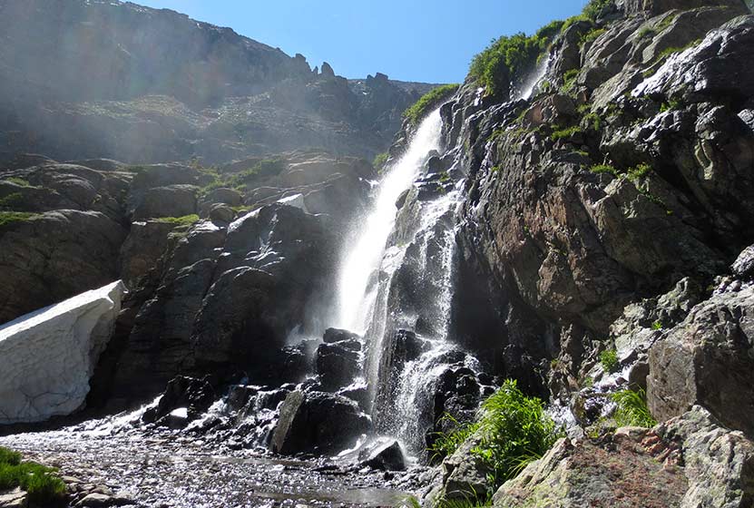
At Timberline Falls (pictured above), the trail up to Lake of Glass Falls is a steep scramble to the right-side of the waterfall. Be aware, the rock may be slick and this area is very steep. Hikers should have good footwear, and may need to be patient for those who are descending this section of the trail. In most of this segment, there is only room for one hiker at a time to safely negotiate the scramble. Many hikers will find the descent of this short portion of the trail more difficult than the way up.
Lake of Glass Falls can be seen trailside, on your left, after the "timberline scramble" and just before reaching Lake of Glass in Rocky Mountain National Park.
List and Links of Destinations Along the Loch Vale Trail
1. Alberta Falls - @ .8
2. The Loch - @ 2.7 miles
3. Timberline Falls - @ 4 miles
4. Lake of Glass & Waterfall -@ 4.2 miles
5. Sky Pond - @ 4.6 miles
Tips & Resources for Hiking to Lake of Glass Falls RMNP :
- Stay the Trail: This area of the park gets a lot of traffic and the waterfall does not have an established trail to it. Because of this, please enjoy the falls from the trail so that we can all reduce the impact on the beautiful, but fragile ecosystem in the high country. Hike on durable surfaces.
- Get There Early: The trailheads fill up early and there are afternoon thunderstorms up at this elevation (and lower elevations in RMNP), so it's always a good idea to begin your hikes early.
- Another Hidden Waterfall There is another small fan cascade that flows out of Sky Pond. Explore our Sky Pond Trail Profile for more information.
- Trail Map for Bear Lake Corridor: Trail Map Link
- Recommended Map for Rocky Mountain National Park: The trail maps provided by Rocky Mountain National Park are usually sufficient. However, if you plan to hike RMNP often, we recommend purchasing a National Geographic Trails Illustrated Map.
- Colorado Road Conditions: Colorado Road Conditions
- After the Hike: Inkwell Brew Coffee
Weather
Map & Driving Directions
Click for Driving Directions
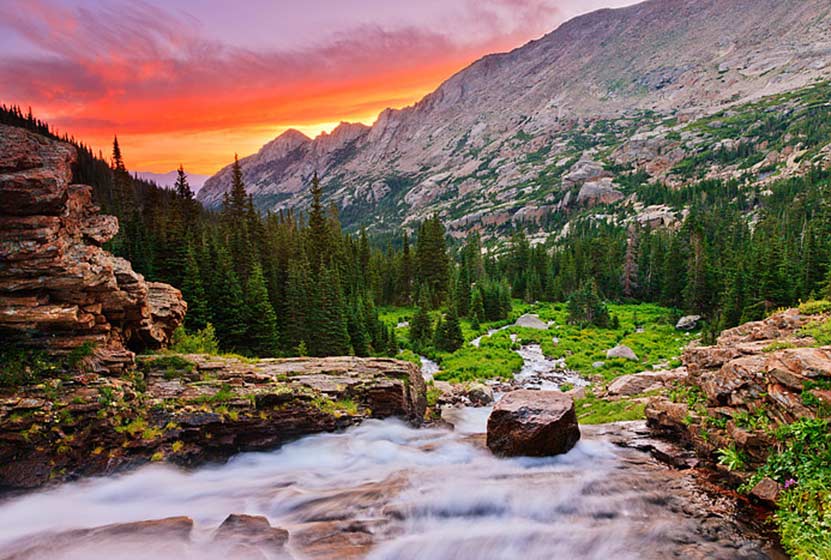
Timberline Falls in Rocky Mountain National Park
Timberline Falls is a demanding 8-mile round-trip waterfall hike in Rocky Mountain National Park. The trail takes you past Alberta Falls up into beautiful Loch Vale. Beyond Timberline Falls hikers will find Lake of Glass, additional falls, and breathtaking Sky Pond.
Glacier Gorge is the home to some of the best hiking in Rocky Mountain National Park, and this waterfall hike is one of the best. Be sure to read through the trailhead and parking information below, because, in the busy season, parking fills up fast. Explore our Timberline Falls trail profile below for trail details, driving directions, maps, and more.
Note: Rocky Mountain National Park now requires timed entry permits from May 27th through October 10th. See the RMNP permits page for more information.
| Hike Distance | 8 miles Round Trip |
|---|---|
| Difficulty | Difficult |
| Duration | Approx 5 hr |
| Trail Type | Out and Back |
| Starting Elevation | 9240′ |
| Elevation Gain | +1510′ |
| Seasons | May-September |
| Dogs | Dogs Prohibited |
| Hike Trail Map | Click for a Map of Timberline Falls |
| Denver Drive Time | 2 hr |
| Driving Directions | Click for Google Map |
| Town Nearest Hike | Estes Park, Colorado |
| Beauty | Waterfall, wildlife: elk, deer, marmots; meadows, lakes, streams |
| Activities | Hiking, photography |
| Fee | Park Pass Required |
Parking & Trailhead Information
The trail up to Timberline Falls begins at either the Glacier Gorge Trailhead (see driving directions above), or at the Bear Lake Trailhead (driving directions). Because the Glacier Gorge Trailhead has a much smaller lot, you may need to drive further up to Bear Lake. There you'll find a short connector trail that will put you on the path down and over to the Glacier Gorge Trail system. In the event that parking at Bear Lake is full, you'll then need to park at the Park & Ride near the Bierstadt Trailhead and take the bus into the trailhead. This service runs 7am to 7PM and more information on the RMNP shuttle bus routes can be found at this link.
The Hike to Timberline Falls
The hike up into the Glacier Gorge/Loch Vale trail system takes you past one of Rocky Mountain National Parks' most accessible waterfalls, Alberta Falls.
After the waterfall, the trail begins to wind up a series of switchbacks for just shy of a mile until a trail junction with the NorthLong's Peak Trail. The trail into Glacier Gorge/Loch Vale then bears right and ascends for about another .5 mile to another trail junction. The trail to the left will take hikers to Glacier Gorge, and the trail to the right takes hikers on a jaunt to Lake Haiyaha (fun to say three times fast) but this trip to Timberline Falls takes the middle trail onto the Loch Vale Trail.
The path follows the path of Icy Brook through a series of longer switchbacks. The brook can be heard gushing and pouring over the rocks below, and one particular switchback there is a great view of its waters casacading through a green canyon (pictured above). At approximately 1 mile after leaving the junction, the trail opens up to more level ground at The Loch. In the distance, beyond the Loch in the west, the cliff face of the Cathedral Wall calls technical climbers to its challenging routes.
The trail continues along the right side of the Loch until another trail junction beyond its western shores and deep in the the lush forest surrounding Icy Brook. The trail up to Timberline Falls, Lake of Glass, and Sky Pond is on the left, and the path to the right will take hikers into the Andrew's Creek area, one of my favorite areas of the Park. Here the trail up to Timberline Falls gets more steep, working its way up through subalpine forest of fir and spruce, the ground bejeweled with Columbine flowers. Soon you'll gain views of the falls in the distance.
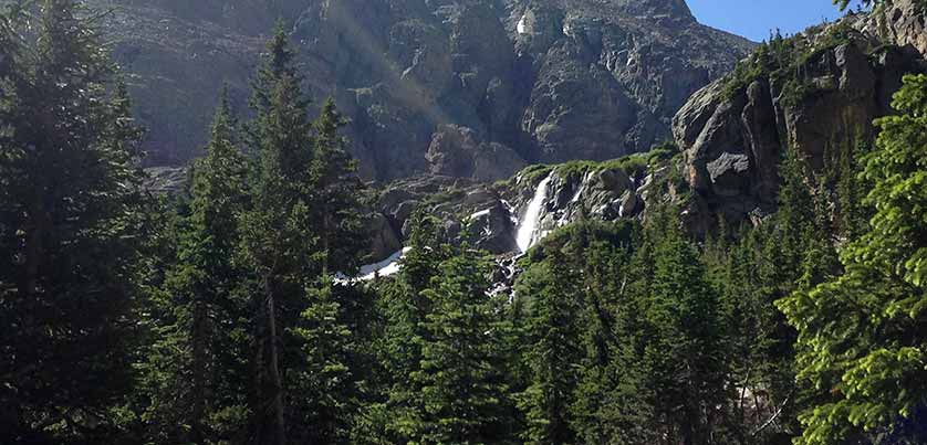
A series of stone stairs takes you to the base of the waterfall. In the late Spring and Early Summer, the falls cut through the winter snowpack and creates fantastic shapes out of the snow. For hikers who want to see more, a very steep and slick trail can be found to far right side of the waterfall. This leads up to the Lake of Glass, it's own waterfall, and to Sky Pond.
Video of Timberline Falls in RMNP
Tips & Resources for Hiking Timberline Falls :
- More to Explore: Be sure to budget extra time to explore the lakes above Timberline Falls.
- Parking: If the parking lot is full at Glacier Gorge Trailhead, there is a shuttle available to take you to the trailhead. See details at the the top of this trailprofile
- Gear: Wear good boots with soles that are good for grabbing the rock if you plan to scramble up the steep trail to Lake of Glass and Sky Pond.
- Pack a Lunch: This is a long hike and you'll certainly need water, but you'll also most likely need fuel for the journey back. Download our hiking guide for a list of great hiking food and snacks.
- Trail Map for Bear Lake Corridor: Trail Map Link
- Packing List: Always pack the 10 Essentials. Download our Hiking Guide to get list and dayhiking packing checklist.
- Colorado Road Conditions: Colorado Road Conditions
- After the Hike: Inkwell & Brew Coffee
Weather
Map & Driving Directions
Alberta Falls Hike at Rocky Mountain National Park
Colorado's Rocky Mountain National Park is full of waterfalls and this hike takes you to one of the most accessible waterfalls in the park. Alberta Falls is one of the most popular, short destination hikes in the park, and for good reason. If you only have time for one short hike on the East Side of RMNP, this is a great choice. To get to Alberta Falls, park at the Bear Lake Trailhead (see google directions below), then follow the signs south for Glacier Gorge and Alberta Falls. The waterfall is .8 miles down the trail from the parking area, make this a 1.6 mile out-and-back hike. Start early and hike the full 2.8 miles of trail in to stunning Mills lake inside Glacier Gorge.
Note: Rocky Mountain National Park now requires timed entry permits from May 27th through October 10th. See the RMNP permits page for more information.
| Hike Distance | 1.6 miles Round Trip |
|---|---|
| Difficulty | Medium |
| Duration | Approx 1 hr |
| Trail Type | Out and Back |
| Seasons | Spring thru Fall |
| Dogs | Prohibited in the Park |
| Hike Trail Map | Click Here for a Trail Map |
| Denver Drive Time | 2 hrs |
| Driving Directions to Alberta Falls, Colorado | Click for Google Map |
| Town Nearest Hike | Estes Park, Colorado |
| Beauty | Sub-Alpine Lake, Mountain Views, Wildlife: Abert's Squirrel, Elk, Bear |
| Activities | Picnicking, Hiking Trails, Snowshoeing |
| Fee | Park Pass Required |
Tips & Resources for Hiking to Alberta Falls
- Visitors and Vacationers: Alberta Falls is a great place to take visiting family and friends because it's not too difficult, and you have a lot of options if you want to explore the park
- Bring a Lunch: Getting this far into the park, even just driving, is quite a trip from the outside world. We suggest packing a lunch so that you can stay longer. And food just tastes better outside anyway.
- Trail Map for Bear Lake Corridor: Trail Map
- Rocky Mountain National Park Maps: Maps Link
- Colorado Road Conditions: Colorado Road Conditions
- After the Hike: Poppy's Pizza
Looking for more waterfalls near Denver? Explore our more than 50 Colorado Waterfall Hikes, our favorite Waterfall Hikes in Rocky Mountain National Park, or 7 Waterfalls within One Hour of Denver.
Weather
Map & Driving Directions
Click for Driving Directions