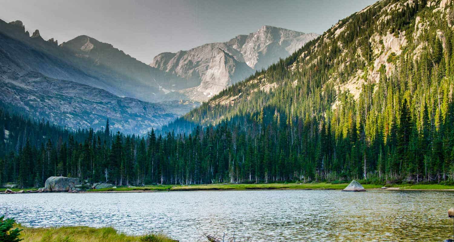
Spruce Lake in Rocky Mountain National Park
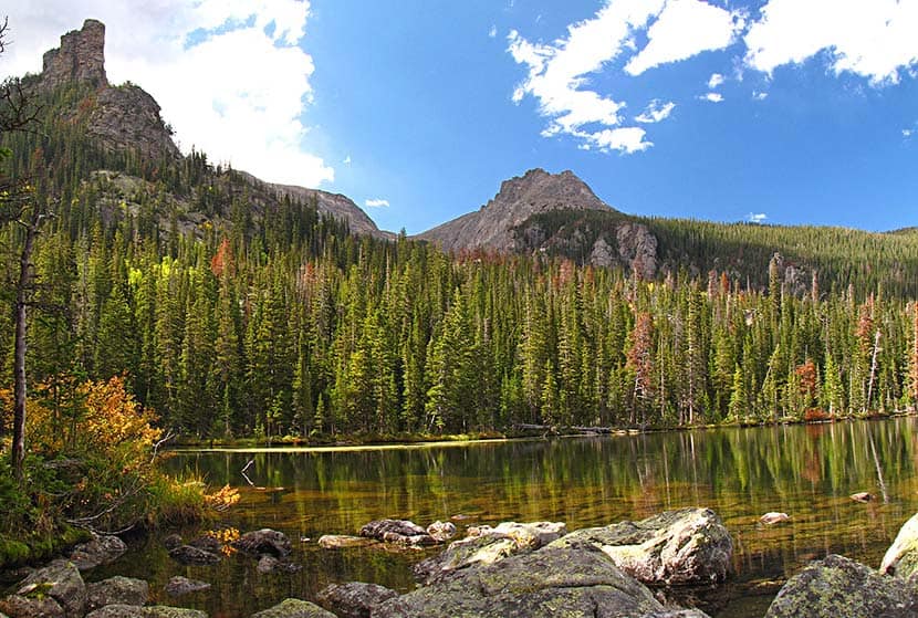
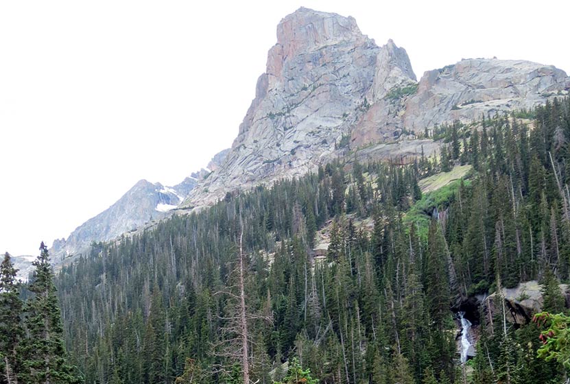
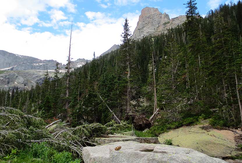
Spruce Lake is an ideal destination in Rocky Mountain National Park for those who are looking to hike through terrain with some variety. After the 3.9 mile hike to Fern Lake, the .9 mile spur trail to Spruce Lake is moderate, with a few steep and rocky segments. It's a great place to find some solitude as few hikers will push on beyond Fern Lake. Views of Castle Rock and Gabletop Mountain fill the landscape, and catch and release fishing is allowed with a valid fishing license. Explore the full Spruce Lake hike profile below for trail map, driving directions, and more of the details and tips you need to enjoy this adventure in Rocky Mountain National Park.
Note: Rocky Mountain National Park now requires timed entry permits from May 27th through October 10th. See the RMNP permits page for more information.
Trail Snapshot: Spruce Lake in Rocky Mountain National Park
| Hike Distance | 9.6 miles Round Trip (from Fern Lake TH) |
|---|---|
| Difficulty | Moderate |
| Duration | Approx 6 hr Round Trip |
| Trail Type | Out and Back |
| Starting Elevation | 8155' |
| Elevation Gain | Approx. +1505' |
| Seasons | Spring through Fall |
| Dogs | Prohibited in RMNP |
| Hike Trail Map | Click for a Map of Spruce Lake RMNP |
| Denver Drive Time | 1 hr 40 min |
| Driving Directions to Fern Lake Trailhead | Click for Google Map |
| Driving Directions to Fern Lake Bus Stop Parking | Click for Google Map |
| Driving Directions to Park & Ride Trailhead | Click for Google Map |
| Town Nearest Hike | Estes Park, Colorado |
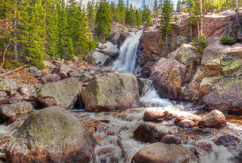
| Beauty | Sub-alpine lakes, mountain views, river, wildflowers, aspen trees, ponderosa pine, waterfalls, wildlife: Abert's squirrel, elk, deer, moose, duck, bear |
| Activities | Picnicking, hiking trails, snowshoeing, fishing: catch and release only |
| Fee | Park Pass Required |
Parking & Trailhead Information for Spruce Lake in RMNP
Parking is more limited in this area of Rocky Mountain National Park, and you'll likely have to park at the Park & Ride then take the shuttle to the Fern Lake Trailhead. You'll find driving directions above to The Fern Lake Trailhead (closest to this hike), the Fern Lake Bus Stop Parking area (very limited parking), and for the Park & Ride lot. See the RMNP Shuttle page for dates and times of service. Avoid parking along Fern Lake road as this damages the road side. If you park or are dropped off at the Fern Lake Bus Station, the hike from the station to the trailhead will add and additional .8 mile, one-way, to your hike.
The Hike: Spruce Lake in RMNP
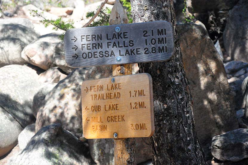
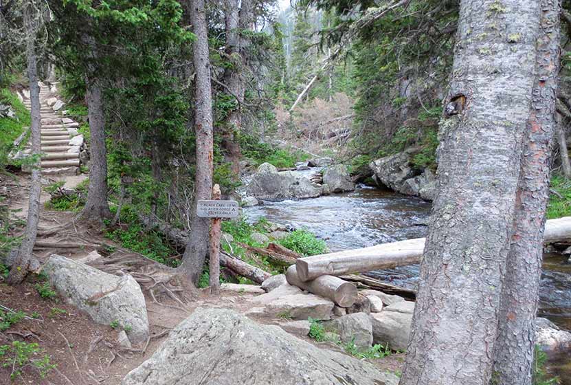
After hiking approximately 3.8 miles up toward Fern Lake from the Fern Lake Trailhead--see the full Fern Lake Trail Profile---the trail will split, just before Fern Lake, and a sign will point the way to Spruce Lake.
The trail up to Spruce Lake is a easy to moderate climb through dense woods ending with a short descent across boulder field and down into the marshland that surrounds much of Spruce Lake.
Because Fern Lake is so close to the Spruce Lake trail junction, it's worth hiking to its shores either before or after hiking to Spruce Lake.
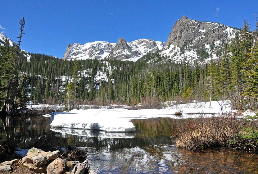
Fern Lake in Rocky Mountain National Park
There are two campsites at Spruce Lake and these must be reserved through the Rocky Mountain National Park Backcountry Offices.
Sights Along the Fern Lake Trail:
- Windy Gulch Cascades - @.4 mile from Fern Lake Trailhead
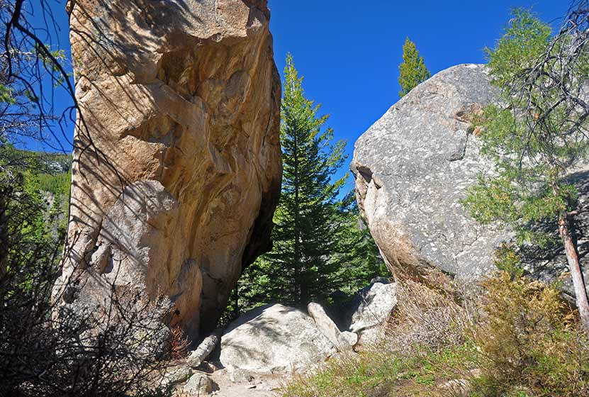
- Arch Rocks - @1.5 mile from Fern Lake Trailhead
- The Pool - @1.7 mile from Fern Lake Trailhead
- Fern Falls - @2.7 mile from Fern Lake Trailhead
- Fern Lake - @3.9 mile from Fern Lake Trailhead
Tips & Resources for Hiking to Spruce Lake in Rocky Mountain National Park
- TIP: It is advisable to arrive early as parking is limited. One may opt to ride a shuttle that drops you off at the trailhead.
- Trekking Poles & Traction Devices are Recommended in Spring and Winter: During this time of year, there can be patches and even longer segments of snow and ice on the trail. Because of this, we recommend Trekking Poles and/or Traction Devices for this trail.
- Bear Country: There is a decent population of Black Bears near Spruce, Fern, and Odessa Lakes. Be bear aware and be sure to dispose of food and waste properly.
- Bring a snack or picnic lunch: The rocks near the Big Thompson River and the shores of Fern Lake can be a great place for picnics. Plus, you're going to need some fuel for this hike.
- Trail Map for Bear Lake Corridor: Trail Map Link
- Packing List: Always pack the 10 Essentials. Download our Hiking Guide to get list and dayhiking packing checklist.
- Colorado Road Conditions: Colorado Road Conditions
- Photo: We would like to express our gratitude to Andrew Mace for sharing such an amazing photograph of this hike to Spruce Lake in RMNP.
- After the Hike: Baba's Burgers & Gyros
Weather
Map & Driving Directions
Click for Driving Directions

Fern Lake in Rocky Mountain National Park
A hike up to Fern Lake begins at the Fern Lake Trailhead on the east side of Rocky Mountain National Park. Along the Fern Lake Trail, hikers pass through Arch Rocks, over a bridge at The Pool, and by three cascade waterfalls. Near the, you'll gain spectacular views of The Gable, Knobtop Mountain, Notchtop Mountain, and Little Matterhorn from its northern shore. Explore the full Fern Lake hike profile below for trail map, driving directions, and more of the details and tips you need to enjoy this adventure in Rocky Mountain National Park.
Note: Rocky Mountain National Park now requires timed entry permits from May 27th through October 10th. See the RMNP permits page for more information.
Trail Snapshot: Fern Lake in Rocky Mountain National Park
| Hike Distance | 7.8 miles Round Trip (from Fern Lake TH) |
|---|---|
| Difficulty | Moderate |
| Duration | Approx 4 to 5 hr Round Trip |
| Trail Type | Out and Back |
| Starting Elevation | 8155' |
| Elevation Gain | Approx. +1375' |
| Seasons | Spring through Fall |
| Dogs | Prohibited in RMNP |
| Hike Trail Map | Click for a Map of Fern Lake RMNP |
| Denver Drive Time | 1 hr 40 min |
| Driving Directions to Fern Lake Trailhead | Click for Google Map |
| Driving Directions to Fern Lake Bus Stop Parking | Click for Google Map |
| Driving Directions to Park & Ride Trailhead | Click for Google Map |
| Town Nearest Hike | Estes Park, Colorado |
| Beauty | Sub-alpine lakes, mountain views, river, wildflowers, aspen trees, ponderosa pine, waterfalls, wildlife: Abert's squirrel, elk, deer, moose, duck, bear |
| Activities | Picnicking, hiking trails, snowshoeing, fishing |
| Fee | Park Pass Required |
Parking & Trailhead Information for Fern Lake in RMNP
Parking is more limited in this area of Rocky Mountain National Park, and you'll likely have to park at the Park & Ride then take the shuttle to the Fern Lake Trailhead. You'll find driving directions above to The Fern Lake Trailhead (closest to this hike), the Fern Lake Bus Stop Parking area (very limited parking), and for the Park & Ride lot. See the RMNP Shuttle page for dates and times of service. Avoid parking along the road as this damages the roadside, and vehicles will be ticketed. If you park or are dropped off at the Fern Lake Bus Station, the hike from the station to the trailhead will add and additional .8 mile, one-way, to your hike.
The Hike: Fern Lake in RMNP
The hike up to the lake is a moderate one. The only demanding aspect is the round-trip distance of 7.8 miles. In the late-Spring and early-Summer, snow may still be on the ground, adding some difficulty to navigating the trail. However, most of the summer months, this is a pleasant hike with a significant amount of shade. The first trailside sight is a cascade tucked away in a gulch above the tail, Windy Gulch Cascades, which can be seen to the North (right) about 1/2 mile in.
The trail continues, following the Big Thompson River. At 1.5 Miles in, the trail weaves through several house-size boulders at Arch Rocks (pictured below).
Just a bit further at 1.7 miles in, a bridge crosses the Big Thompson River near the spot of its confluence with both Spruce and Fern Creeks. This area is know as The Pool. After crossing the bridge at The Pool, there is a trail junction. The trail up to the lake splits off to the right.
Just about 1/10th of a mile past The Pool, an unnamed set of cascades can be heard and seen to the right of the trail (pictured below).
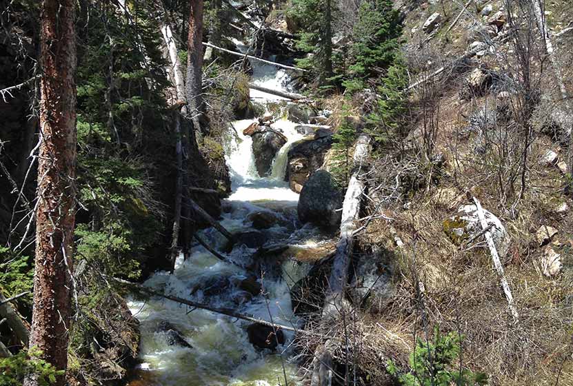
The next mile of trail continues up a set of switchbacks that make a steady climb through the forest to Fern Falls (pictured below).
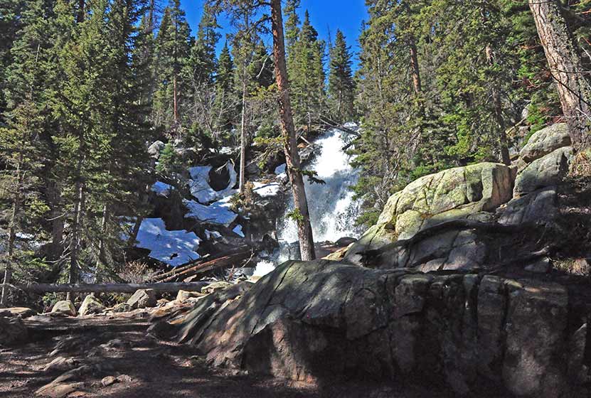
After Fern Falls, there is just 1.1 mile left to the Lake. This is the segment that may still be packed with snow. At the Lake, hikers will find a panorama of sights. From here, a social trail can be traced down to Marguerite Falls, a small set of hidden cascades along Fern Creek and just below the Lake.
Fern Lake can be a jumping off point for several other destinations:
- Spruce Lake - .9 mile from Fern Lake (one-way)
- Odessa Lake - .7 mile from Fern Lake (one-way)
- Lake Helene - 1.8 mile from Fern Lake (one-way)

Tips & Resources for Hiking to Fern Lake in Rocky Mountain National Park
- TIP: It is advisable to arrive early as parking is limited. One may opt to ride a shuttle that drops you off at the trailhead.
- Trekking Poles & Traction Devices are Recommended in Spring and Winter: During this time of year, there can be patches and even longer segments of snow and ice on the trail. Because of this, we recommend Trekking Poles and/or Traction Devices for this trail.
- Bring Snack or Picnic Lunch: You'll need fuel for this hike. There are a lot of great spots along the shores of the Lake to sit down and enjoy a picnic lunch.
- Trail Map for Bear Lake Corridor: Trail Map Link
- Packing List: Always pack the 10 Essentials. Download our Hiking Guide to get list and dayhiking packing checklist.
- Colorado Road Conditions: Colorado Road Conditions
- After the Hike: Baba's Burgers & Gyros
Weather
Map & Driving Directions
Click for Driving Directions
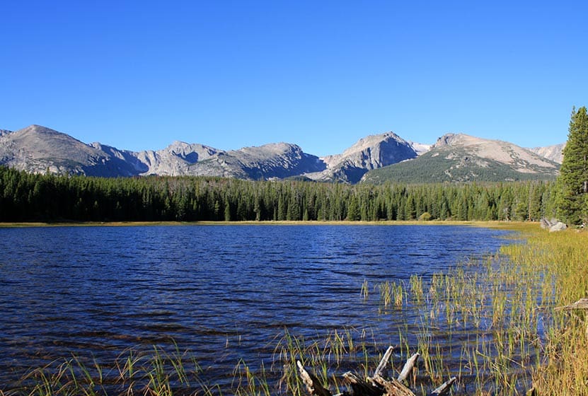
Bierstadt Lake in Rocky Mountain National Park
Bierstadt Lake is a short destination hike in Rocky Mountain National Park to a sub-alpine lake with great panoramic views. At Bierstadt Lake, the trail forms a 1 mile loop along its shores, making it a perfect leisurely hike with friends. Bierstadt lake can be accessed from several different trailheads with differing terrain and demand. Explore the full Bierstadt Lake hike profile below for trail map, driving directions, and more of the details you need to enjoy this adventure in Rocky Mountain National Park.
Note: Rocky Mountain National Park now requires timed entry permits from May 27th through October 10th. See the RMNP permits page for more information.
Trail Snapshot: Bierstadt Lake in Rocky Mountain National Park
| Hike Distance | 3.2 to 4.8 miles Round Trip (depending on trailhead and adding loop) |
|---|---|
| Difficulty | Easy to Moderate |
| Duration | Approx 2 hrs Round Trip |
| Trail Type | Out and Back or Lollipop Loop |
| Starting Elevation | 8850′ |
| Elevation Gain | +566' from Bierstadt TH, +255' from Bear Lake TH |
| Seasons | Spring through Fall, Winter Snowshoeing |
| Dogs | Dogs Prohibited in RMNP |
| Hike Trail Map | Click for a Trail Map |
| Denver Drive Time | 2 hr |
| Driving Directions to Bierstadt Lake Trailhead | Click for Google Map |
| Driving Directions to the Bear Lake Trailhead | Click for Google Map |
| Driving Directions to Park & Ride Trailhead | Click for Google Map |
| Town Nearest Hike | Estes Park, Colorado |
| Beauty | Sub-alpine lakes, mountain views, wildlife: Abert's squirrel, elk, deer, waterfowl, moose; aspen trees |
| Activities | Picnicking, Hiking Trails, Snowshoeing |
| Fee | Park Pass Required |
Parking & Trailhead Information for Bierstadt Lake Trail
Bierstadt Lake can be accessed from several trailheads in Rocky Mountain National Park. Driving directions to all of these trailheads are available in the Bierstadt Lake trail snapshot above. Review the options below to find the best fit for your hiking plans.
From the Bierstadt Trailhead: Limited parking and the most difficult route because of the elevation gain traversing Bierstadt Moraine. This route is 1.4 miles to the lake with +566' elevation gain.
From Bear Lake Trailhead: Recommended for those looking for a less demanding hike to Bierstadt Lake. This way is 1.6 miles to the lake with about +255' elevation gain.
From the Park & Ride lot in RMNP: There is a trail on the northwestern edge of the parking lot that leads directly to Bierstadt Lake. It is approximately 1.5 miles from the parking lot to Bierstadt Lake and a less demanding route than hiking from the Bierstadt Trailhead.
The Hike: Bierstadt Lake Trail in RMNP
The hike to Bierstadt Lake will be different depending on your starting point. I've hiked the trail starting at the Bierstadt Trailhead. It's demanding. The Bierstadt Moraine will require a lot from your quads. So, if you take this route, be sure to bring some trekking poles.
The route from Bear Lake can be accessed by hiking the paved path from the trailhead to Bear Lake, then taking the first right-hand trail, which is the one that leads to Flattop Mountain. You may be thinking, "Flattop is in the west, and Bierstadt Lake is in the east." You're right, and the trail will soon (after approx. 1/2 mile) split. At this first junction, the right-hand path will take you Northeast into the Mill Creek Basin area.
Down in Mill Creek Basin, a spur trail, to the right, will lead to Bierstadt Lake. If you want to make your hike a bit longer, you can pass this spur trail, and hike further through the basin for about another 1/2 mile until you encounter a 2nd spur trail that leads (to the right/east) over to Lake Bierstadt.
Hikers can pick a spot to rest and enjoy the sites of the lake, or they can continue around the 1 mile loop trail that encircles it. The best views are from the east side, and are worth the extra distance to take in some incredible views of the Rocky Mountains.
Tips & Resources for Hiking to Bierstadt Lake in RMNP
- Trekking Poles: For most hikes in RMNP, especially if you are traveling on unmaintained trails, we recommend using Trekking Poles. They take a lot of weight off the knees and help in navigating uneven terrain.
- TIP: The Bierstadt Lake trailhead has limited parking. You can opt to park at Bear Lake, or the Park & Ride trailhead instead.
- Fishing: Bierstadt Lake is not on the list of fishable lakes in RMNP.
- Trail Map for Bear Lake Corridor Trails: Trail Map Link
- Packing List: Always pack the 10 Essentials. Download our Hiking Guide to get list and dayhiking packing checklist.
- Colorado Road Conditions: Colorado Road Conditions
- Photo: We would like to express our gratitude to Chris for sharing such an amazing photograph of this hike to Bierstadt Lake in RMNP.
- After the Hike: Baba's Burgers & Gyros
Weather
Map & Driving Directions
Click for Driving Directions
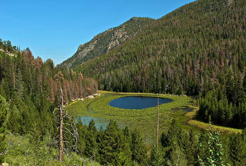
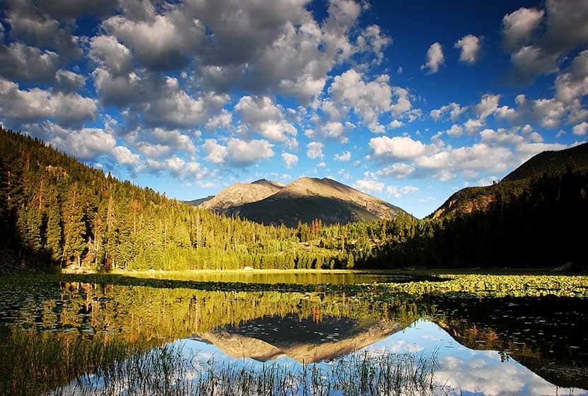
Cub Lake in Rocky Mountain National Park
Cub Lake, in Rocky Mountain National Park, is known for its unusual halo of lily pads. The 4.6 mile, roundtrip hike dazzles with its variety - especially the wildflowers. You'll pass through wetlands, glacial formations, and meadows before arriving at the lake. Explore the full Cub Lake hike profile below for trail map, driving directions, and all the details you need to enjoy this adventure in Rocky Mountain National Park.
| Hike Distance | 4.6 miles Round Trip |
|---|---|
| Difficulty | Moderate |
| Duration | Approx 3 hrs Round Trip |
| Trail Type | Out and Back |
| Starting Elevation | 8080' |
| Elevation Gain | Approx. +540' |
| Seasons | Spring through Fall, Winter Snowshoeing |
| Dogs | Prohibited in RMNP |
| Hike Trail Map | Click for a Map of Cub Lake RMNP |
| Denver Drive Time | 1 hr 40 min |
| Driving Directions to Cub Lake Trailhead | Click for Google Map |
| Driving Directions to Fern Lake Trailhead | Click for Google Map |
| Driving Directions to Park & Ride Trailhead | Click for Google Map |
| Town Nearest Hike | Estes Park, Colorado |
| Beauty | Sub-alpine lakes, mountain views, meadows, river, wildlife: Abert's squirrel, elk, deer, moose, duck, bear; yellow pond lilies and wildflowers |
| Activities | Picnicking, Hiking Trails, Snowshoeing |
| Fee | Park Pass Required |
Parking & Trailhead Information for Cub Lake
The Cub Lake Trailhead in Rocky Mountain National Park has a very small parking area where only 7 to 8 vehicles can park. Chances are, if you don't arrive early in the morning, you'll need to park just .3 mile further down the road at the Fern Lake Bus Stop parking area. If both lots are full, then your best bet is to park in the RMNP Park & Ride lot and use the shuttle service to get to the Cub Lake Trailhead. Please do not park alongside the road. This causes significant erosion and damage to roadside--and you might get a ticket.
The Hike to Cub Lake in RMNP
One of the things we love about Rocky Mountain National Park is the diversity of landscapes. The Cub Lake trail is a great example. Over the course of the 2.3 mile journey to the lake, you'll encounter plenty of sights that you will want to take in. The trail begins in the wetland meadows of Moraine Park, replete with willows and other wetland shrubs. It's a perfect habitat for a variety of birds, including western tanagers and warblers.
The trail crosses several bridges, including one over the Big Thompson River, (just a mountain stream at this point) then begins a climb into stands of evergreens, and then into an unusual area scraped by an ancient glacier, riddled with unusual boulders and rock. Leaving this strange landscape, the trail goes down to another meadow area and meets up with the horse trail that runs along the southern border of Moraine Park. The local YMCA offers horseback rides along this area, so keep your eyes out for horses. At this trail junction, the trail that leads up to Cub Lake is the one to the right.
Soon, the trail goes from easy to quite demanding, working its way up a series of switchbacks before reaching Cub Lake. Two things will catch your eye at Cub Lake. First is the strange halo formation made by the yellow pond lilies that grow around the inside of the lake. The middle of the lake, open to reflect the sky, looks like a big, blue eye staring into the heavens. The second thing you may notice is a large stand of dead trees from a forest fire in the 1970s.
Tips & Resources for Hiking to Cub Lake in Rocky Mountain National Park
- TIP: It is advisable to arrive early as parking is limited. One may opt to ride a shuttle that drops you off at the trailhead.
- Trail Map for Bear Lake Corridor: Trail Map Link
- Packing List: Always pack the 10 Essentials. Download our Hiking Guide to get list and dayhiking packing checklist.
- Colorado Road Conditions: Colorado Road Conditions
- Photo: We would like to express our gratitude to Jeff Livingston for sharing such an amazing photograph of this hike to Cub Lake in RMNP.
- After the Hike: Baba's Burgers & Gyros
Weather
Map & Driving Directions
Click for Driving Directions
Solitude Lake Hike in Rocky Mountain National Park
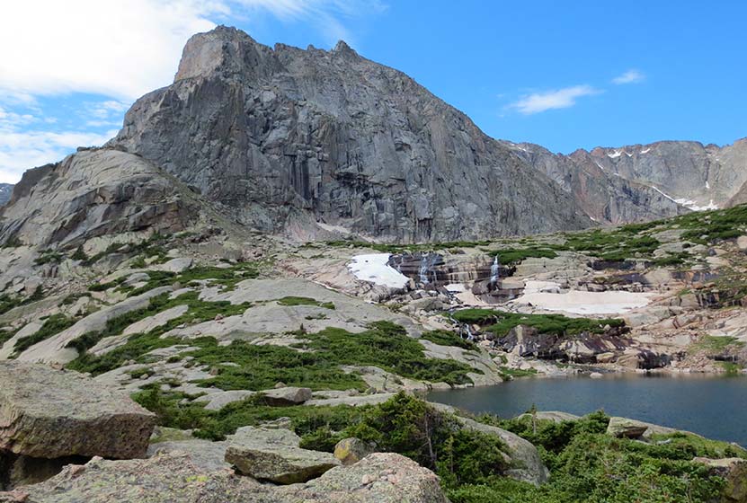
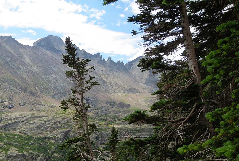
Solitude Lake is an alpine lake situated in the heart of Rocky Mountain National Park. Solitude is aptly named, as it is hidden from the main trail system, situated high above Glacier Gorge in the shadow of Thatchtop and Arrowhead Peak. Because the hike to Solitude and its twin sister, Shelf Lake, require travel on unmaintained trails, it is best suited for more experienced hikers who are familiar with Rocky Mountain National Park and who are have honed their land navigation skills. Full details can be found in the trail profile for Shelf Lake. Explore the full Solitude Lake hike profile below for trail map, driving directions, and all the tips and resources for this hike in Rocky Mountain National Park.
Note: Rocky Mountain National Park now requires timed entry permits from May 27th through October 10th. See the RMNP permits page for more information.
Trail Snapshot: Solitude Lake in Rocky Mountain National Park
| Hike Distance | 9 miles Round Trip |
|---|---|
| Difficulty | Difficult |
| Duration | Approx 5-7 hrs Round Trip |
| Trail Type | Out and Back |
| Starting Elevation at Glacier Gorge Trailhead | 9240′ |
| Elevation Gain | Approx +2400′ |
| Seasons | Mid-Summer-September |
| Dogs | Prohibited in RMNP |
| Hike Trail Map | National Geographic Trails Illustrated Map |
| Denver Drive Time | 2 hr |
| Driving Directions to Glacier Gorge Trailhead | Click for Google Map |
| Town Nearest Hike | Estes Park, Colorado |
| Beauty | Waterfalls, wildlife: elk, deer, marmots; meadows, lakes, streams, wildflowers |
| Activities | Hiking, photography, fishing |
| Fee | Park Pass Required |
Solitude Lake is located about a quarter mile beyond Shelf Lake. Between the Shelf and Solitude are an unusual set of cascades, Shelf Lake Falls. Above the falls, you'll find a beautiful array of alpine wildflowers and breathtaking views of Longs Peak, Keyboard of the Winds, and the broad valley of Glacier Gorge. The hike up to Solitude take hikers past Alberta Falls, Mills Lake, and Shelf Creek Falls.
A final reminder: This hike is not on maintained trails, is a long hike, and demanding. Hikers should be familiar with RMNP and developed the skills needed for backcountry travel. A more detailed trail profile for locating the trail and a brief description of its course and hazards are can be found on the Shelf Lake hike profile page. If you are looking for a demanding hike on maintained trails in Rocky Mountain National Park, we would recommend exploring trail profiles for Sky Pond and Black Lake.
Tips & Resources for Hiking to Solitude Lake in Rocky Mountain National Park
- Recommended Map for Rocky Mountain National Park: The trail maps provided by Rocky Mountain National Park are usually sufficient. However, if you plan to hike RMNP often, we recommend purchasing a National Geographic Trails Illustrated Map.
- Packing List: Always pack the 10 Essentials. Download our Hiking Guide to get list and dayhiking packing checklist.
- Colorado Road Conditions: Colorado Road Conditions
- After the Hike: Inkwell & Brew Coffee
Weather
Map & Driving Directions
Click for Driving Directions
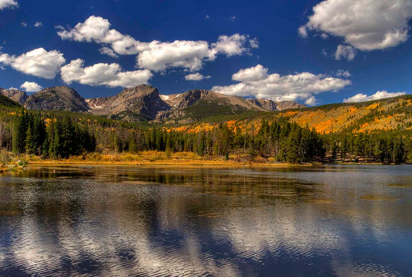
Sprague Lake Loop Hike in Rocky Mountain National Park
At Sprague Lake you'll find an easy loop hike with some stunning views of the mountains that make Rocky Mountain National Park famous. It's a perfect hike in RMNP for young families because the trail is short and has no real elevation gain. With diverse wildlife and a beautiful, peaceful lake, this is one of those spots you should not miss in RMNP. Explore the full Sprague Lake hiking profile below for trail map, driving directions, and all the details you need to enjoy this Colorado adventure in Rocky Mountain National Park.
Trail Snapshot: Sprague Lake Loop in Rocky Mountain National Park
| Hike Distance | 1/2 mile |
|---|---|
| Difficulty | Easy |
| Duration | Approx 30 min |
| Trail Type | Loop |
| Starting Elevation | 8690' at Trailhead |
| Elevation Gain | Approx +20′ |
| Seasons | Spring through Fall, Winter Snowshoeing |
| Dogs | Prohibited in RMNP |
| Hike Trail Map | Click for a Map of Sprague Lake RMNP |
| Denver Drive Time | 2 hr |
| Driving Directions to Sprague Lake Trailhead | Click for Google Map |
| Town Nearest Hike | Estes Park, Colorado |
| Beauty | Sub-alpine lake, mountain views, wildlife: Abert's squirrel, elk, bear, beavers, waterfowl, moose, ducks, Canadian geese |
| Activities | Picnicking, hiking trails, snowshoeing |
| Conditions at Bear Lake Trailhead | Click Here |
| Fee | Park Pass Required |
Sprague Lake Loop Hike
Sprague Lake is a 13-acre lake named after Abner Sprague, an early resident of the Estes Park area who ran a game lodge on the this property which is now part of Rocky Mountain National Park. To access the 1/2 mile loop hike around Sprague Lake, cross the bridge near the parking area. Be sure to pause at the bridge to look for trout. We've spotted an enormous brown trout motoring in these waters near the bridge. It's a regular spawning area in the autumn, so this little segment of water can become quite crowded with fish.
After the bridge, the trail can be hiked to either the left or the right around the perimeter of Sprague Lake. Keep your eyes peeled for Beaver and Moose, both residents of the area. You will be more likely to spot wildlife in the early morning hours.
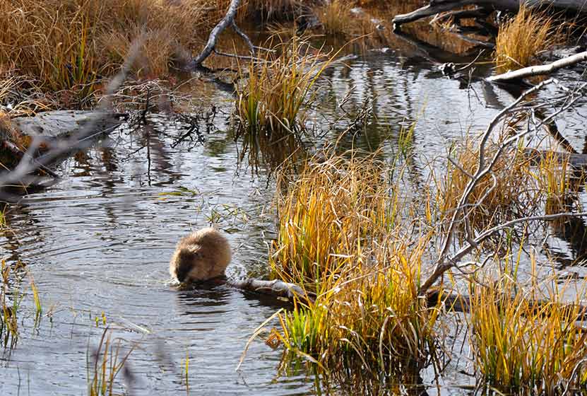
A Beaver at Sprague Lake RMNP
In the early spring, the trail will likely still be under snow. However, this is such a popular area that it should be easy to spot the trail left by others. As you make your way to the northeastern rim of Sprague Lake, you'll gain views of the continental divide, including Hallett Peak. This is a perfect spot to set up your camera for an iconic photo of RMNP.
In the Fall, this is one of the better spots in Rocky Mountain National Park to view the aspen trees changing on the distant mountains.
Tips & Resources for Hiking to Sprague Lake :
- TIP: Hiking shoes are recommended if you hike during early spring or late winter as you might need to pass through snow on the trail.
- TIP: If you get out early on a spring morning, you might be lucky enough to spot a moose or more.
- Rocky Mountain National Park Trail Conditions: Click for RMNP Trail Conditions
- Trail Map for Bear Lake Corridor: Trail Map Link
- Colorado Road Conditions: Colorado Road Conditions
- After the Hike: Poppy's Pizza
- Photo: We would like to express our gratitude to Tim Stacks for sharing such a beautiful photograph of this hike at Sprague Lake.
Weather
Map & Driving Directions
Click for Driving Directions
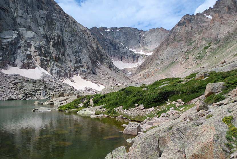
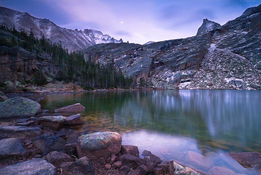
Shelf Lake in Rocky Mountain National Park
This demanding hike in Rocky Mountain National Park takes you off the beaten path to two high-mountain lakes, and grants views of several waterfalls along the way. This trail profile provides helpful details for making the journey to Shelf Lake, Shelf Lake Falls, and Solitude Lake. Because the hike to Shelf Lake requires travel on unmaintained trails, it is best suited for more experienced hikers who are familiar with Rocky Mountain National Park, and who are have honed their land navigation skills. Explore the full Shelf Lake hike profile below for trail map, driving directions, and all the details you need to enjoy this adventure in Rocky Mountain National Park.
Note: Rocky Mountain National Park now requires timed entry permits from May 27th through October 10th. See the RMNP permits page for more information.
Trail Snapshot: Shelf Lake in Rocky Mountain National Park
| Hike Distance | 8.5 miles Round Trip |
|---|---|
| Difficulty | Difficult |
| Duration | Approx 5-7 hrs Round Trip |
| Trail Type | Out and Back |
| Starting Elevation at Glacier Gorge Trailhead | 9240′ |
| Elevation Gain | Approx +2300′ |
| Seasons | Mid-Summer-September |
| Dogs | Prohibited in RMNP |
| Hike Trail Map | National Geographic Trails Illustrated Map |
| Denver Drive Time | 2 hr |
| Driving Directions to Glacier Gorge Trailhead | Click for Google Map |
| Town Nearest Hike | Estes Park, Colorado |
| Beauty | Waterfalls, wildlife: elk, deer, marmots; meadows, lakes, streams, wildflowers |
| Activities | Hiking, photography, fishing |
| Fee | Park Pass Required |
The Hike to Shelf Lake RMNP
Shelf Lake sits high above Glacier Gorge, nested in a cirque between Thatchtop and McHenrys Peak. The journey begins at the Glacier Gorge Trailhead. However, the Bear Lake Trailhead--which has more parking--affords access to the Glacier Gorge Trail system, adding approximately .1 mile jaunt. The first scenic point along the trail, Alberta Falls, is found at .8 mile in. The trail leads to Mills Lake (at 2.8 miles). Here you'll gain breathtaking views of Longs Peak and the Keyboard of the Winds. The trail skirts the east side of Mills Lake, and makes its way past Jewel Lake.
Soon, you'll come to a fork in the trail with a sign that reads Glacier Gorge campsite, and Black Lake 1.2 miles. The Glacier Gorge Campsite is probably the best site in the entire park and to reserve it, you will have to call the backcountry office as soon as their season opens for reservations. I've spent several months in the park over the years, and this site is unrivaled. However, the trail up to Shelf Lake requires hikers to continue on the main trail, the one that leads towards Black Lake.
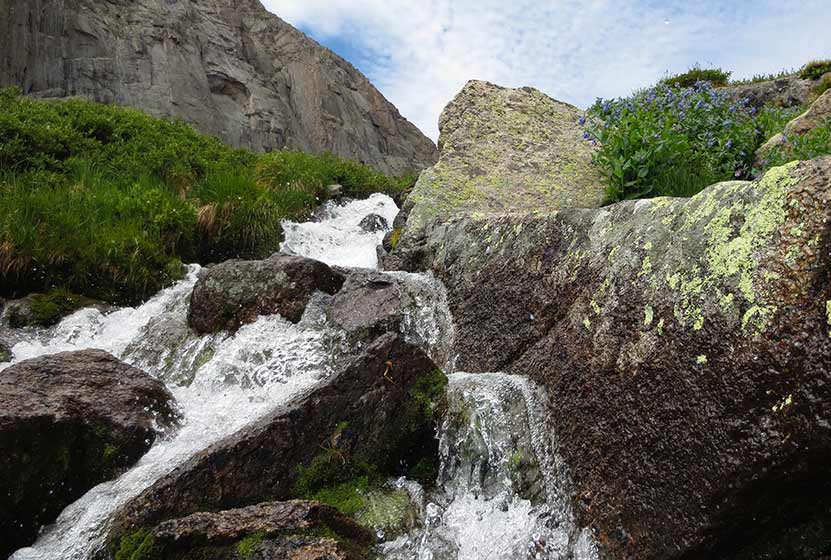
Past the sign, the trails climbs a set of stairs and eventually, after approximately 1/4 mile, emerges into an area that is full of downed trees from what appears to have been an avalanche many years ago. If you keep your ears and eyes peeled, you'll see Shelf Creek Falls spilling out into a couple segments of waterfalls up along the cliffs and trees below Arrowhead (see photo below). The hike up to Shelf Lake will afford more views of these falls.
The unmaintained social trail is located across glacier creek, to the right (West) and can be difficult to find. After a short buschwack across a marshy area to Glacier Creek, a natural crossing point should come into view. Hikers should find two large, flat rocks (pictured below). This has been named, Helicopter Rock. Other crossing points are not advised as the gap widens and the current of Glacier Creek can be swift and very cold.
On the other side of the creek, the real work begins. The trail is marked--at times--by cairns, but it's often a route-finding puzzle. My rule of thumb is always to avoid anything steep and/or slippery. There is also a TON of deadfall along the trail, which adds further need for caution and slows progress. About half of the way up, you'll encounter another waterfall, Shelf Creek Falls, as the trail bends again toward Shelf Creek.
The last half mile is demanding, hiking around 1000 vertical feet up to Shelf Lake. Don't forget to stop, breath, and take in the views of Glacier Gorge. At this point, hikers are truly in the heart of Rocky Mountain National Park.
At Shelf Lake, you'll hear water streaming over the shelves of rock above the lake. In the early days of Summer, the meltwater cuts beautiful formations out of the snow and ice as it cascades from Shelf Creek Falls into Shelf Lake. View the video below to see it.
You've hiked this far, so it would be a shame to miss Solitude Lake which is a short hike further above Shelf Lake. The wildflowers between the two lakes are outstanding!
A final reminder: This hike is not on maintained trails, is a long hike, and demanding. Hikers should be familiar with RMNP and developed the skills needed for backcountry travel. If you are looking for a demanding hike on maintained trails in Rocky Mountain National Park, we would recommend exploring trail profiles for Sky Pond and Black Lake.
Tips & Resources for Hiking to Shelf Lake in Glacier Gorge RMNP
- Start Very Early: Because this hike is so demanding, and because thunderstorms jet through Glacier Gorge on many summer days, it's wise to begin the journey early in the morning.
- Parking: If the parking lot is full at Glacier Gorge Trailhead, there is a shuttle available to take you to the trailhead, or you can park at the Bear Lake Trailhead.
- Bring Food: My legs were shot after hiking back to the main trail, and my energy was waning. I had packed a few snacks, but wish I had packed more. So, bring something to give you an energy boost for your hike back to the Glacier Gorge Trailhead.
- Trekking Poles: Trekking poles proved really helpful, especially in navigating the descent.
- Recommended Map for Rocky Mountain National Park: The trail maps provided by Rocky Mountain National Park are usually sufficient. However, if you plan to hike RMNP often, we recommend purchasing a National Geographic Trails Illustrated Map.
- Packing List: Always pack the 10 Essentials. Download our Hiking Guide to get list and dayhiking packing checklist.
- Colorado Road Conditions: Colorado Road Conditions
- After the Hike: Inkwell & Brew Coffee
Weather
Map & Driving Directions
Click for Driving Directions
Black Lake in Rocky Mountain National Park
Black Lake is among the most spectacular lakes in Rocky Mountain National Park. The journey to Black Lake is a strenuous, 10 mile, round-trip hike with significant elevation gain--but both the destination of Black Lake and the several waterfalls along the way make it more than worth the effort. Explore the full Black Lake hiking trail profile for trail map, driving directions, and all the details you need to enjoy this adventure in Rocky Mountain National Park
Note: Rocky Mountain National Park now requires timed entry permits from May 27th through October 10th. See the RMNP permits page for more information.
Trail Snapshot: Black Lake Falls in Rocky Mountain National Park
| Hike Distance | 10 mile Round Trip |
|---|---|
| Difficulty | Difficult |
| Duration | Approx 6 hrs Round Trip |
| Trail Type | Out and Back |
| Starting Elevation | 9240' at Trailhead |
| Elevation Gain | +1430′ |
| Seasons | May-September |
| Dogs | Prohibited in RMNP |
| Hike Trail Map | Click for a Trail Map |
| Denver Drive Time | 2 hr |
| Driving Directions to Glacier Gorge Trailhead | Click for Google Map |
| Town Nearest Hike | Estes Park, Colorado |
| Beauty | Waterfalls, wildlife: elk, deer, marmots; meadows, lakes, streams, wildflowers, aspen trees |
| Activities | Hiking, photography, fishing |
| Fee | Park Pass Required |
Parking & Trailhead Information for Black Lake RMNP, Colorado
The trail to Black Lake begins at either the Glacier Gorge Trailhead (see driving directions above), or at the Bear Lake Trailhead (driving directions). Because the Glacier Gorge Trailhead has more limited parking, you may need to drive further up to Bear Lake. There you'll find a short connector trail that will put you on the path to the Glacier Gorge Trail system. In the event that parking at Bear Lake is full, you'll then need to park at the Park & Ride near the Bierstadt Trailhead and take the bus into the trailhead. This service runs 7am to 7PM and more information on the RMNP shuttle bus routes can be found at this link.
The Hike to Black Lake RMNP
Hiking to Black Lake takes you into the Glacier Gorge Trail system with many wonderful destinations including Mills Lake, Jewel Lake, and Ribbon Falls. Be sure to review the different waypoints and destinations below so that you don't miss any of the sites. The first destination--and one you can't miss because it's right along the trail--is at .8 miles, Alberta Falls. After the waterfall, the trail ascends toward an eventual trail junction. The way to Black Lake is to follow the Glacier Gorge/Loch Vale trail that bears right. This trail climbs steadily for about another half mile until arriving at a second major trail junction with three options. The left-hand trail leads into Glacier Gorge and eventually to Mills Lake.
List and Links of Destinations From Glacier Gorge Trailhead to Black Lake
1. Glacier Gorge Trailhead
2. Alberta Falls - @ .8 mile
3. Mills Lake - @ 2.8 miles
4. Jewel Lake - @ 3.2 miles
5. Ribbon Falls - @ 4.8 miles
6. Black Lake - @ 5 miles
At Mills Lake, the trail follows its eastern shore for about 1/2 a mile until arriving at Jewel Lake, a much smaller body of water surrounded by lush green marshes. The next segment of the trail is my favorite, a challenging stretch of approximately 2 miles that leads hikers across bogs, and through verdant forest where the snow hangs on well into the summer months. In fact, this stretch may prove very difficult in the spring and early weeks of June depending on that year's weather. The trail continues to follow Glacier Creek up into the higher reaches of the park and ever closer to Keyboard of the Winds, the jagged rock formation ever present against the eastern sky.
Keyboard of the Winds is named for the sounds that flow from it's sharp edges as high winds whistle and roar across its peaks. Be sure to stop and listen for the music. It can be a mesmerizing experience.
If snow is still on the ground, then the last bit of the trail may require some basic route finding. The established trail skirts the left/east side of Black Lake, but can at times be hard to find. Stay close to the creek and you should be okay. Soon, hikers will encounter Ribbon Falls, a beautiful slide waterfall. Black Lake is just .2 mile further up the trail. This final segment is steep and requires negotiating some rocks and boulders before coming over the rise to gain breathtaking views of Black Lake.
Tips & Resources for Hiking Black Lake in Glacier Gorge RMNP :
- Start Early: The hike to Black Lake is challenging and hikers will want to begin early to avoid being in this exposed area when afternoon thunderstorms often tear through the area in Summer.
- Trekking Poles in Spring and Winter: Because the trail is high in the mountains, the snow and ice can hang around into late Spring and even early Summer, then pick up again in the Fall. Because of this, we recommend Trekking Poles and/or Traction Devices for this trail when the trail conditions are such.
- Parking: If the parking lot is full at Glacier Gorge Trailhead, there is a shuttle available to take you to the trailhead, or you can park at the Bear Lake Trailhead.
- Rocky Mountain National Park Trail Conditions: Click for RMNP Trail Conditions
- Trail Map for Bear Lake Corridor Trails: Trail Map Link
- Rain Gear Recommended: On every occasion I've been into Glacier Gorge, it's been gorgeous weather--and it rained. So, bring Rain gear. In the summer months, thunderstorms can form quickly in this area, especially in the afternoon--just another reason to begin your hike early.
- Packing List: Always pack the 10 Essentials. Download our Hiking Guide to get list and dayhiking packing checklist.
- Colorado Road Conditions: Colorado Road Conditions
- After the Hike: Inkwell Brew Coffee
- Photo: We would like to express our gratitude to Erik Page for sharing such an amazing photograph of this hike.
Weather
Map & Driving Directions
Click for Driving Directions

Jewel Lake Hike in Rocky Mountain National Park
Jewel Lake is a 6.4 mile round-trip hike into Glacier Gorge in Rocky Mountain National Park. This hike in RMNP takes you first past stunning Mills Lake. Less than half a mile beyond Mills you'll discover Jewel Lake under the shadow of the jagged eastern ridge known as Keyboard of the Winds. Explore the full Jewel Lake hiking trail profile below for trail map, driving directions, and all the details you need to enjoy this adventure in Rocky Mountain National Park.
Note: Rocky Mountain National Park now requires timed entry permits from May 27th through October 10th. See the RMNP permits page for more information.
Trail Snapshot: Jewel Lake in Rocky Mountain National Park
| Hike Distance | 6.4 miles Round Trip |
|---|---|
| Difficulty | Moderate |
| Duration | Approx 3 to 4 hrs Round Trip |
| Trail Type | Out and Back |
| Starting Elevation | 9240' at Trailhead |
| Elevation Gain | Approx. +727' |
| Seasons | May-September |
| Dogs | Prohibited in RMNP |
| Hike Trail Map | Click for a Map of Jewel Lake in Glacier Gorge |
| Denver Drive Time | 2 hr |
| Driving Directions to Glacier Gorge Trailhead | Click for Google Map |
| Town Nearest Hike | Estes Park, Colorado |
| Beauty | Waterfall, wildlife: elk, deer, marmots, moose; meadows, lakes, streams, wildflowers, aspen trees |
| Activities | Hiking, photography, fishing |
| Fee | Park Pass Required |
Parking & Trailhead Information for Jewel Lake RMNP, Colorado
The trail to Jewel Lake begins at either the Glacier Gorge Trailhead (see driving directions above), or at the Bear Lake Trailhead (driving directions). Because the Glacier Gorge Trailhead has more limited parking, you may need to drive further up to Bear Lake. There you'll find a short connector trail that will put you on the path to the Glacier Gorge Trail system. In the event that parking at Bear Lake is full, you'll then need to park at the Park & Ride near the Bierstadt Trailhead and take the bus into the trailhead. This service runs 7am to 7PM and more information on the RMNP shuttle bus routes can be found at this link.
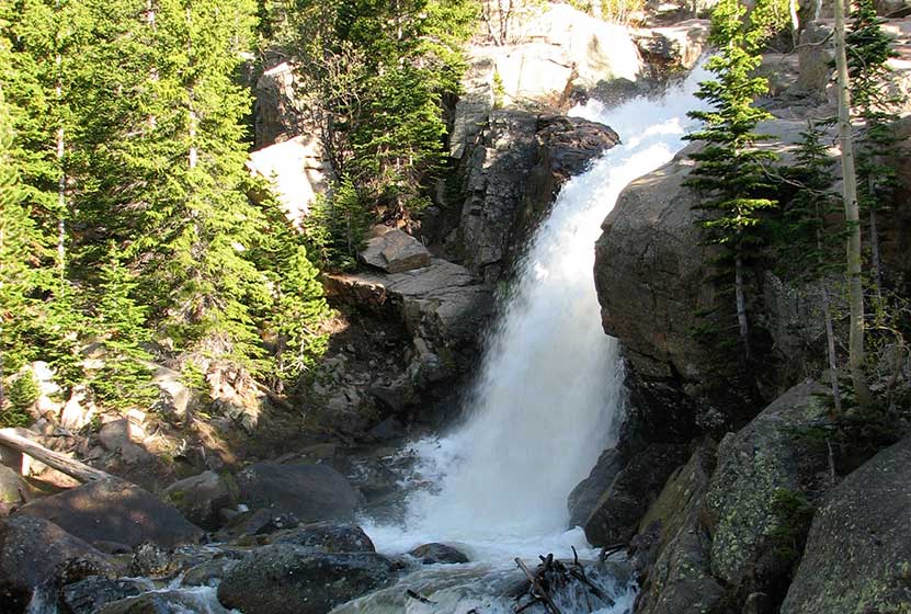
Alberta Falls - Just .8 mile up the trail on your way to Jewel Lake
The Hike to Jewel Lake RMNP
Hiking to Jewel Lake takes you into the Glacier Gorge Trail system with many wonderful destinations including Mills Lake and Ribbon Falls. Be sure to review the different RMNP destinations below to know your options. The first destination--and one you can't miss because it's right along the trail--is at .8 miles, Alberta Falls. After the waterfall, the trail ascends toward an eventual trail junction. The way to Jewel Lake is to follow the Glacier Gorge/Loch Vale trail that bears right. This trail climbs steadily for about another half mile until arriving at a second major trail junction with three options. The left-hand trail leads into Glacier Gorge and eventually to Jewel Lake.
List and Links of Destinations From Glacier Gorge Trailhead to Black Lake
1. Glacier Gorge Trailhead
2. Alberta Falls - @ .8 mile
3. Mills Lake - @ 2.8 miles
4. Jewel Lake - @ 3.2 miles
5. Ribbon Falls - @ 4.8 miles
6. Black Lake - @ 5 miles
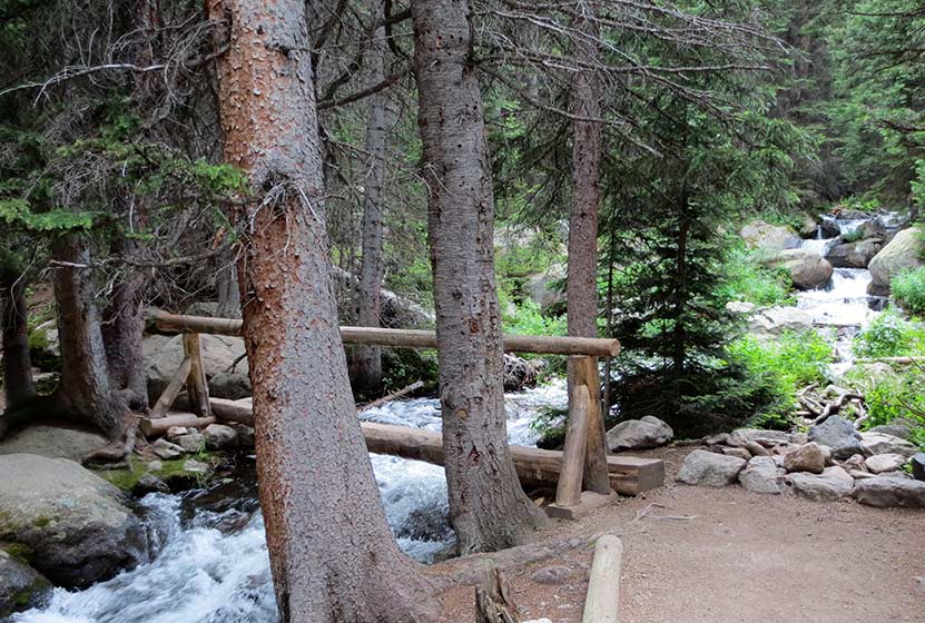
Footbridge Across Glacier Creek on the Way to Jewel Lake
At 2.8 miles, hikers will arrive at the edge of Mills Lake. Mills is much larger, and the path to Jewel Lake skirts its eastern shoreline for about 1/2 a mile.
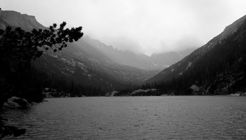
Mills Lake, Shrouded in the Mists of an Afternoon Rainstorm
Jewel Lake is surrounded by extensive marshes, that have a green beauty of their own. Because the foot traffic dies off quite a bit when past Mills Lake, you'll likely find Jewel a quieter spot for a picnic and a good place to fish for brook trout.
Tips & Resources for Hiking Jewel Lake in Glacier Gorge RMNP :
- A Favorite Spot: I've had the chance to spend many weeks backpacking in RMNP, and the Glacier Gorge campsite that is just beyond Jewel Lake is one of the best in the Park. It must be reserved, and only those who call into the backcountry office early in the season get the chance to book it.
- Parking: As always, go early. If the parking lot is full at Glacier Gorge Trailhead, there is a shuttle available to take you to the trailhead, or you can park at the Bear Lake Trailhead.
- Rocky Mountain National Park Trail Conditions: Click for RMNP Trail Conditions
- Trail Map for Bear Lake Corridor: Trail Map Link
- Rain Gear Recommended: On every occasion I've been into Glacier Gorge, it's been gorgeous weather--and it rained. So, bring Rain gear. In the summer months, thunderstorms can form quickly in this area, especially in the afternoon.
- Packing List: Always pack the 10 Essentials. Download our Hiking Guide to get list and dayhiking packing checklist.
- Colorado Road Conditions: Colorado Road Conditions
- After the Hike: Inkwell Brew Coffee
- Photo: We would like to express our gratitude to J. Gempler for sharing such an amazing photograph of this hike to Jewel Lake RMNP.
Weather
Map & Driving Directions
Click for Driving Directions
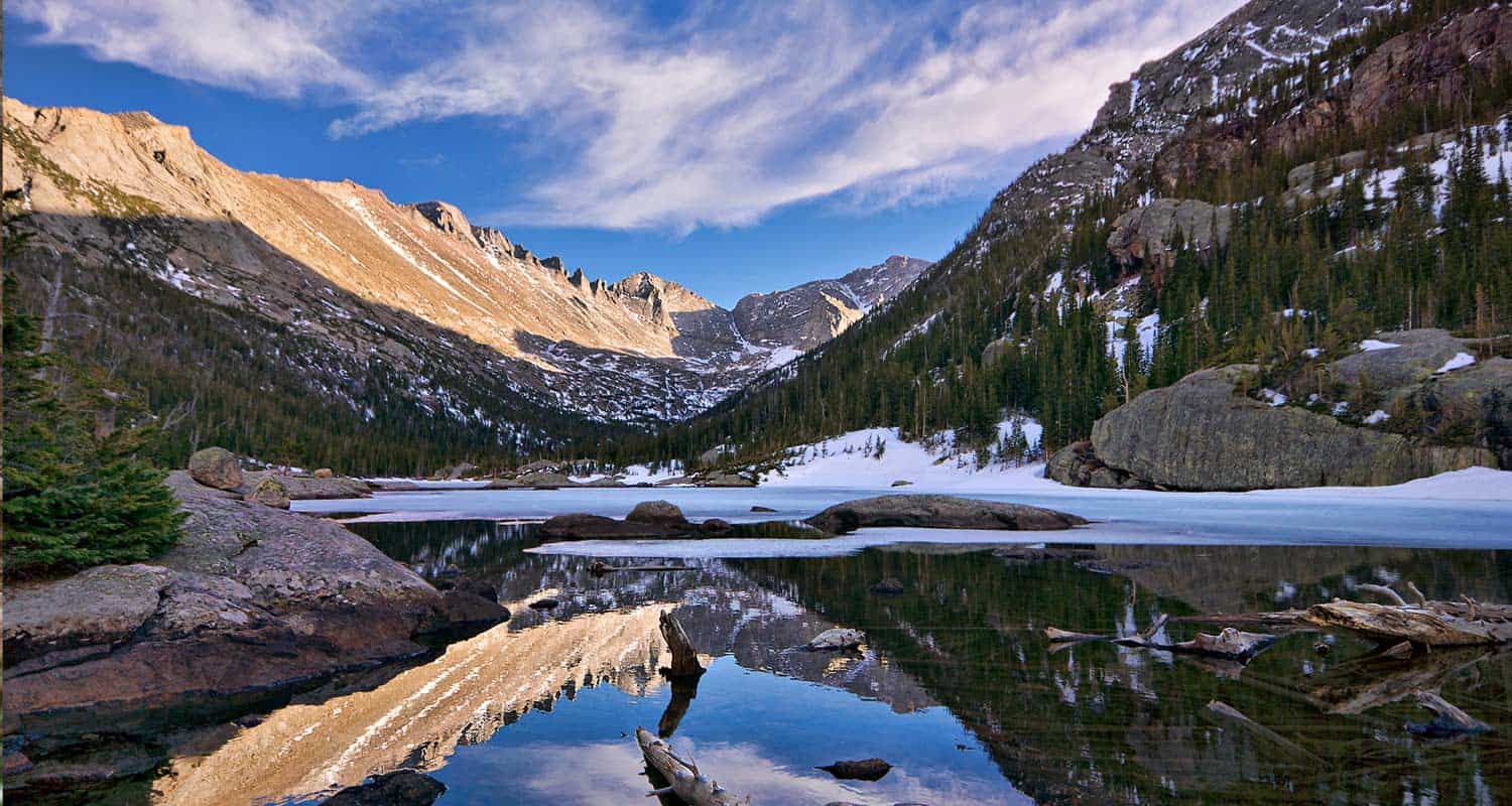
Mills Lake Hike in Rocky Mountain National Park
The hike up to Mills Lake is a steady, uphill, 5.6 mile trek into the breathtaking Glacier Gorge trail system of Rocky Mountain National Park. You'll be entranced by spectacular views of mountain ridges, rugged peaks, and the color of wildflowers along the trail. Glacier Gorge provides surprises at almost every turn. Explore the full Mills Lake hike profile below for trail map, driving directions, and all the details you need to enjoy this adventure in Rocky Mountain National Park.
Note: Rocky Mountain National Park now requires timed entry permits from May 27th through October 10th. See the RMNP permits page for more information.
Trail Snapshot: Mills Lake in Rocky Mountain National Park
| Hike Distance | 5.6 miles Round Trip |
|---|---|
| Difficulty | Moderate |
| Duration | Approx 2-3 hrs Round Trip |
| Trail Type | Out and Back |
| Starting Elevation | 9240' at Trailhead |
| Elevation Gain | +750′ |
| Seasons | May-September |
| Dogs | Prohibited in RMNP |
| Hike Trail Map | Click for a Map of Mills Lake in Glacier Gorge |
| Denver Drive Time | 2 hr |
| Driving Directions to Glacier Gorge Trailhead | Click for Google Map |
| Town Nearest Hike | Estes Park, Colorado |
| Beauty | Waterfall, wildlife: elk, deer, marmots; meadows, lakes, streams, wildflowers, aspen trees |
| Activities | Hiking, photography |
| Fee | Park Pass Required |
Parking & Trailhead Information for Mills Lake RMNP
The trail up to Mills begins at either the Glacier Gorge Trailhead (see driving directions above), or at the Bear Lake Trailhead (driving directions). Because the Glacier Gorge Trailhead has more limited parking, you may need to drive further up to Bear Lake. There you'll find a short connector trail that will put you on the path to the Glacier Gorge Trail system. In the event that parking at Bear Lake is full, you'll then need to park at the Park & Ride near the Bierstadt Trailhead and take the bus into the trailhead. This service runs 7am to 7PM and more information on the RMNP shuttle bus routes can be found at this link.
The Hike to Mills Lake RMNP
The first destination--and one you can't miss because it's right along the trail--is at .8 miles, Alberta Falls. After the waterfall, the trail climbs toward an eventual trail junction. The way to Mills Lake is to follow the Glacier Gorge/Loch Vale trail that bears right. This trail ascends for about another half mile to a second major trail junction with three options. The left-hand trail leads into Glacier Gorge and to Mills Lake.
Mills Lake is one of the fishable lakes in Rocky Mountain National Park. The lake is known to contain rainbow trout, brook trout, and Greenback cutthroats. Most of the high mountain lakes in Rocky Mountain National Park are not completely thawed and warmed up until mid-summer. As a result, you may experience--like I have--some pretty lethargic fish at Mills in the early days of summer.
Photographers will find Mills Lake an equally perfect place to make that big catch. The lake, in the early morning hours, can be placid enough to reflect the backdrop of the beautiful east ridge of Glacier Gorge that has been named, the Keyboard of the Winds.
Tips & Resources for Hiking Mills Lake RMNP :
- Bugs: You might need a bug spray in the summer months when the mosquitos multiply.
- Parking Tip: If the parking lot is full at Glacier Gorge Trailhead, there is a shuttle available to take you to the trailhead, or you can park at the Bear Lake Trailhead.
- Rain Gear Recommended: On every occasion I've been into Glacier Gorge, it's been gorgeous weather--and it rained. So, bring Rain gear. In the summer months, thunderstorms can form quickly in this area, especially in the afternoon.
- Packing List: Always pack the 10 Essentials. Download our Hiking Guide to get list and dayhiking packing checklist.
- Rocky Mountain National Park Trail Conditions: Click for RMNP Trail Conditions
- Trail Map for Bear Lake Corridor: Trail Map Link
- Colorado Road Conditions: Colorado Road Conditions
- Photo: We would like to express our gratitude to Steve Bratman for sharing such an amazing photograph of this hike.
- After the Hike: Inkwell Brew Coffee
Weather
Map & Driving Directions
Click for Driving Directions