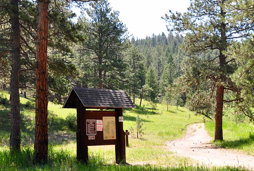
Bear Creek Trail at Lair o' the Bear Park
Lair o' the Bear is, in our family's opinion, the best family hike near Denver. First, the drive into the canyon on Bear Creek road is beautiful. Once at the park you'll find great hiking trail options, the cool water of bear creek, great parking, and some good picnic spots. There are open areas as well as shade. Our one big suggestion is to keep your kiddos close to you on the busier trail segments as this is also a mountain biking mecca. Explore the details below in our profile of this Jefferson County, Colorado park.
Trail Snapshot: Bear Creek Trail at Lair O' the Bear
| Hike Distance | 1.6 Miles |
|---|---|
| Difficulty | Easy |
| Duration | 1 hr 15 min |
| Trail Type | Out and Back |
| Seasons | All Season |
| Dogs | Allowed on Leash |
| Hike Trail Map | Click for a Trail Map |
| Denver Drive Time | 30 min |
| Driving Directions | Click for Google Map |
| Town Nearest Hike | Denver, Colorado |
| Beauty | Bear Creek, Meadows, Wildlife: Beaver, American Dippers aka Water Ouzel |
| Activities | Hiking, Birdwatching, Mountain Biking, Fly Fishing, Picnics |
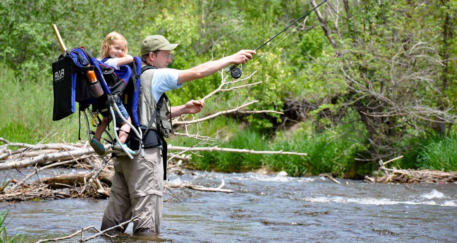
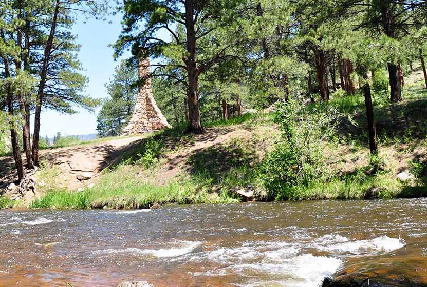
Lair O'the Bear is fantastic for families because this hike has lot of shade, a mostly level path, the sounds and sights of water, and a few great areas for picnics in this Colorado park. On top of all of that, it's one of the most accessible Denver trails just out of town in the foothills. Within Lair O the Bear park, the Bear Creek Trail follows the creek for 1.6 miles of trail. Approximately 1 mile of the trail runs West from the parking area, and .6 of a mile to the East. But that is just within the park boundaries; the actual trail continues following the creek in both directions, so you can explore even more of this beautiful canyon and riparian landscape. You can also fish Bear Creek in Lair O the Bear. I've not had any luck yet, so I'd appreciate any tips in the comment section below.

Tips & Resources for Hiking at Lair o' the Bear :
- Bikes: There are some hiker only trail segments, but most are open to mountain bikes - and there are A LOT of them, especially on the weekends. So, just hike aware and let your kids know that bikes may be zipping by.
- Picnic: Take a picnic lunch or dinner. There are some great picnic areas along the river at Lair o' the Bear.
- Birding: This is a great place to teach your kids (or yourself) some tree and bird identification. The riparian ecosystem is pretty diverse at Lair o' the Bear.
- Lair o’ the Bear Park Trail Map: Trail Map Link
- Colorado Road Conditions: Colorado Road Conditions
- After the Hike: Ice Cream @ The Blue Cow

Weather
Map & Driving Directions
Click for Driving Directions

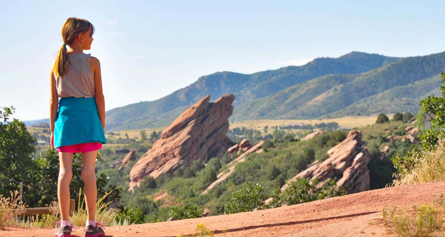
Willow Creek Trail at Roxborough State Park
Entering Roxborough State Park is like walking into another world. The red rock and wildlife--and if you are lucky--the low lying cloud cover, conspire to make for a great escape just south of Denver. The Willow Creek trail makes for a short hike in Roxborough is a perfect way to begin exploring the park. Scroll down to get all the information you need for this trail: driving directions to the trailhead, trail map links, and more details.
Trail Snapshot: Willow Creek Trail at Roxborough State Park
| Hike Distance | 1.4 mile Round Trip |
|---|---|
| Difficulty | Easy |
| Duration | Approx 1 hr Round Trip |
| Trail Type | Loop |
| Seasons | All Year |
| Dogs | Not Allowed in Roxborough State Park |
| Hike Trail Map | Click for a Map of Willow Creek Trail at Roxborough State Park |
| Denver Drive Time | 45 min |
| Driving Directions to Willow Creek Trail at Roxborough State Park | Click for Google Map |
| Town Nearest Hike | Littleton, Colorado |
| Beauty | Red rock formations, meadows, wildlife: mule deer, eagles, foxes, birds |
| Activities | Hiking, birdwatching, Visitors' Center |
| Fee | Entrance Fee or State Parks Pass Required |
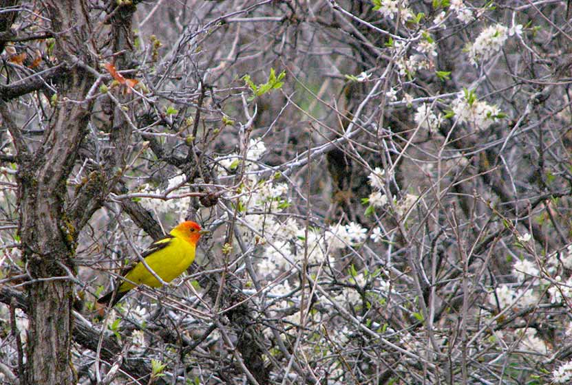
A birdwatcher's paradise. Roxborough State Park is Denver's twin sister of Garden of the God's in Colorado Springs. The park has cataloged over 140 species of birds that have been viewed in the park. On our first hike in the park, we encountered several Western Tanager's among the scrub oak.
On our first visit, we brought our dog and had to turn the car around. Roxborough State Park has quite a bit of wildlife and sensitive plant life, so pets are not allowed. Mountain biking and camping are also not permitted.
This would be in our top 5 for visiting family and friends because this Douglas County hike stays at a lower elevation, is easy, and offers awe inspiring views. This is one of our favorite places to visit in the mornings.
Tips & Resources for Hiking Willow Creek Trail at Roxborough State Park :
- To get the best views of wildlife: Go when there is less traffic: Evenings, Mornings, and Weekdays.
- TIP: There is a picnic area with tables just outside the Visitors' Center.
- TIP: Be on the lookout for poison ivy along the sides of the trail. Know how to identify it, so that you can avoid it. But don’t let that deter you from the park. You just need to keep an eye out. See our post on how to identify and treat poison ivy.
- Trail Map for Roxborough State Park: Trail Map Link
- Colorado Road Conditions: Colorado Road Conditions
- After the Hike: Enchanted Grounds Coffee Shop
- Roxborough State Park Brochure
- Roxborough State Park Site
Weather
Map & Driving Directions
Click for Driving Directions
Castlewood Canyon State Park Trails
Because Castlewood Canyon State Park is hidden in the plains--and not the mountains--near Denver, it's often an overlooked State park of Colorado. But, whether you're hiking or rock climbing it's a beautiful and geologically unusual place to explore. It boasts a waterfall, homestead ruins, a stream, caves and clefts, and a lot of fairly easy hikes. Below you'll find more information on how to get to the park, trail map links, and links to several hiking options in Castlewood Canyon.
Trail Snapshot: Castlewood Canyon State Park Trails
| Hike Distance | Less than 1/4 mile to 4 Miles |
|---|---|
| Difficulty | Easy to Moderate |
| Duration | 15 Minutes to 2.5 hours |
| Trail Type | Out and Back and Loop |
| Seasons | Year Round |
| Dogs | Allowed On Leash but not on East Canyon Trail |
| Hike Trail Map | Click for a Map of Castlewood Canyon State Park Trails |
| Denver Drive Time | 50 min |
| Driving Directions to Castlewood Canyon State Park | Click for Google Map |
| Town Nearest Hike | Elizabeth, Colorado |
| Beauty | Meadows, creek, waterfall, interesting geology, canyon views, ruins |
| Activities | Rock climbing, hiking, picnic areas, visitors center |
| Fee Required | Visit Colorado State Parks Site |
Not just a canyon, this Colorado State Park features ruins, a waterfall, and unusual geological formations. The park is riddled with 15 trails, ranging from 1/4 mile to 4 miles, so you have a lot of options. The Canyon View Nature Trail (1.2 miles) is a great example of a handicap accessible trail in Colorado. The East Parking (see map below) offers the most hiking options, while the West Parking area leads to shorter hikes to the Castlewood Canyon climbing areas and the longest (4 mile) East Canyon Trail.
Some Trails In Castlewood Canyon
-
Waterfall Hike at Castlewood Canyon State Park
-
Cliff & Climbers Trail at Castlewood Canyon State Park
-
Homestead Trail at Castlewood Canyon State Park
-
Cave Trail at Castlewood Canyon State Park
-
Canyon View Nature Trail at Castlewood Canyon State Park
- This may be the most accessible waterfall near Denver. A short .17 mile hike from the trailhead. Click on the red link above to go to the waterfall hike trail profile page.
- A short but more demanding hike in Castlewood Canyon where you can explore the crags along the cliffs of the park.
- an easy to medium hike at the west park entrance. Check out the hiking profile to see how to turn this .7 mile trail into a 2 or 4 mile loop hike.
- only a quarter mile round trip up to a small cave in the west side of Castlewood Canyon State park.
- 2.4 mile round trip hike with interpretive signs that takes you along the rim of Castlewood Canyon. One of the best handicap accessible trails near Denver.
Tips & Resources for Hiking Castlewood Canyon State Park Trails:
- TIP: Castlewood Canyon offers some shade, but you are often in the sun. So, bring your sunscreen and apply it liberally.
- TIP: We would also suggest an early morning or sunset hike as these are the best times to observe wildlife.
- TIP: Though it's not the largest of Colorado waterfalls, you'll still hear it before you see it. The waterfall is accessed from Creek Bottom Trail on the West Side of the park.
- TIP: Pets are allowed on a leash but there are some specific trail restrictions, so make sure to read the signs. Enjoy this wonderful hike in the grasslands of Douglas County, Colorado.
- Trail Map: Castlewood Canyon State Park Trails
- Colorado Road Conditions: Colorado Road Conditions
- After the Hike: Crowfoot Valley Coffee
Weather
Map & Driving Directions
Click for Driving Directions
O Fallon Park Trails
hese hiking trails near Evergreen, Colorado weave through the Bear Creek area in O'Fallon Park. It's a great place to launch into the Bear Creek Canyon area. Because there are a lot of options, be sure to download the trail map and look over the five different trail options listed below in the hike profile. Scroll down for the full O'Fallon Park Trails profile and to find driving directions, pdf map, and full trail details.
| Hike Distance | 1.3 to 7 miles |
|---|---|
| Difficulty | Easy to Moderate |
| Duration | Approx 1 to 5 hrs |
| Trail Type | 3 Loop Trails and Out & Back |
| Seasons | All Year |
| Dogs | Allowed On Leash |
| Hike Trail Map | Click for a Map of O'Fallon Park Trails |
| Denver Drive Time | 35 min |
| Driving Directions to O'Fallon Park Trails | Click for Google Map |
| Town Nearest Hike | Evergreen, Colorado |
| Beauty | Mountain peak views, Bear Creek & brooks, wildflowers, & butterflies |
| Activities | Picnic areas, horseback riding, mountain biking |
O'Fallon Park is part of a series of Jefferson County and Denver Mountain Parks that are connected by Bear Creek and the Bear Creek Trail. Quartz riddles the trails and butterflies alight on flowers along the five trails that weave through the park. The O'Fallon Park picnic area is right beside Bear Creek and plenty of shade provided by the Ponderosa Pines that cover it.
Fishing at O'Fallon Park may get you some rainbow and brown trout!
Trails at O'Fallon Park
1- Meadow View Loop (2.5 miles): We actually hiked this as an out-and-back from the lot up to the vista. Great views up there, but be ready for a steady gain in elevation. It's some work, but it's worth it.
2- Panorama Point - (1.3 miles out-and-back)
3-West Ridge Loop - (3 miles)
4- Picnic Loop (1.3 miles): Stays closer to the picnic areas and makes for a nice easy walk with the family before or after lunch.
5-Bear Creek Trail - This trail runs 7 miles from Pence Park parking lot to the Lair o' the Bear Park lot. Medium in difficulty and a mountain biking mecca.

Tips & Resources for Hiking O'Fallon Park Trails :
- TIP: This is another park that can fill quickly on the weekends, but it's mainly the picnic areas. It's not necessary to go early, but it's not a bad idea.
- TIP: Keep alert for mountain bikers, especially on the Bear Creek Trail. Most of the other trails are hiker only.
- TIP: Bring a picnic breakfast or lunch.
- O'Fallon Park Trail Map: Trail Map Link
- Colorado Road Conditions: Colorado Road Conditions
- After the Hike: Beau Jo’s Pizza
Weather
Map & Driving Directions
Click for Driving Directions
South Valley Park Trails
The trails of South Valley Park are perfect for an after work hike or run in South Denver. The expansive valley near the neighborhood of Ken Caryl is enclosed on its eastern side by the exposed red rock formations of the hogback and the green foothills to the west. Views to the south are incredible, making South Valley Park especially enchanting during the early morning hours and at twilight.. Explore the full hiking profile below for full trail details, driving directions and more.
Trail Snapshot: South Valley Park Trails
| Hike Distance | 0.5 mile to 3 miles |
|---|---|
| Difficulty | Easy |
| Duration | Approx 1 to 2 hrs |
| Trail Type | Out & Back and Loop |
| Seasons | All Year |
| Dogs | Allowed On Leash |
| Hike Trail Map | Click for a Map of South Valley Park Trails |
| Denver Drive Time | 30 min |
| Driving Directions to South Valley Park Trails | Click for Google Map |
| Town Nearest Hike | Littleton, Colorado |
| Beauty | Red rock formations, meadows, elk, deer, birdwatching, great sunsets |
| Activities | Hiking, horseback riding, mountain biking |
| Video | Click For Video |
Red Rock towers along the eastern wall of South Valley Park and the foothills begin to the west. Almost 1000 acres of meadow and rock offer a near perfect escape from the sounds of the city. The time lapse below shows a great example of a South Valley Park sunrise.
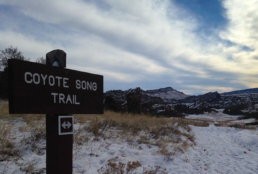
6 Trails wind through the park. The best place to start is with the South Valley Park Coyote Song Trail. It's a an out an back trail that takes you right through the main meadow. It also connects with the Swallow Trail to form a loop, making your hike about 1.8 miles. The Lyons Back Trail takes you from the Coyote Song Trail and up over the red rock where you can hike trails developed by the Ken-Caryl Ranch foundation.
Tips & Resources for Hiking South Valley Park Trails :
- Don't miss the Coyote Song Trail: The sunsets are wonderful and the park tends to be quiet in the evenings. The Coyote Song Trail is a great way to begin or wind down the day.
- TIP: The Parking area on our map link is the larger of the two. However, you can also begin at the south lot off of Deer Creek Canyon Road. Click here for directions. This gives you a closer connection to the Elk Grazing Trail (seasonal) area and Deer Creek Canyon Park.
- TIP: The red rock calls to be climbed, but climbing is prohibited in this park.
- South Valley Park Trail Map: Trail Map Link
- Colorado Road Conditions: Colorado Road Conditions
- After the Hike: Atlas Coffee in Littleton
Weather
Map & Driving Directions
Click for Driving Directions