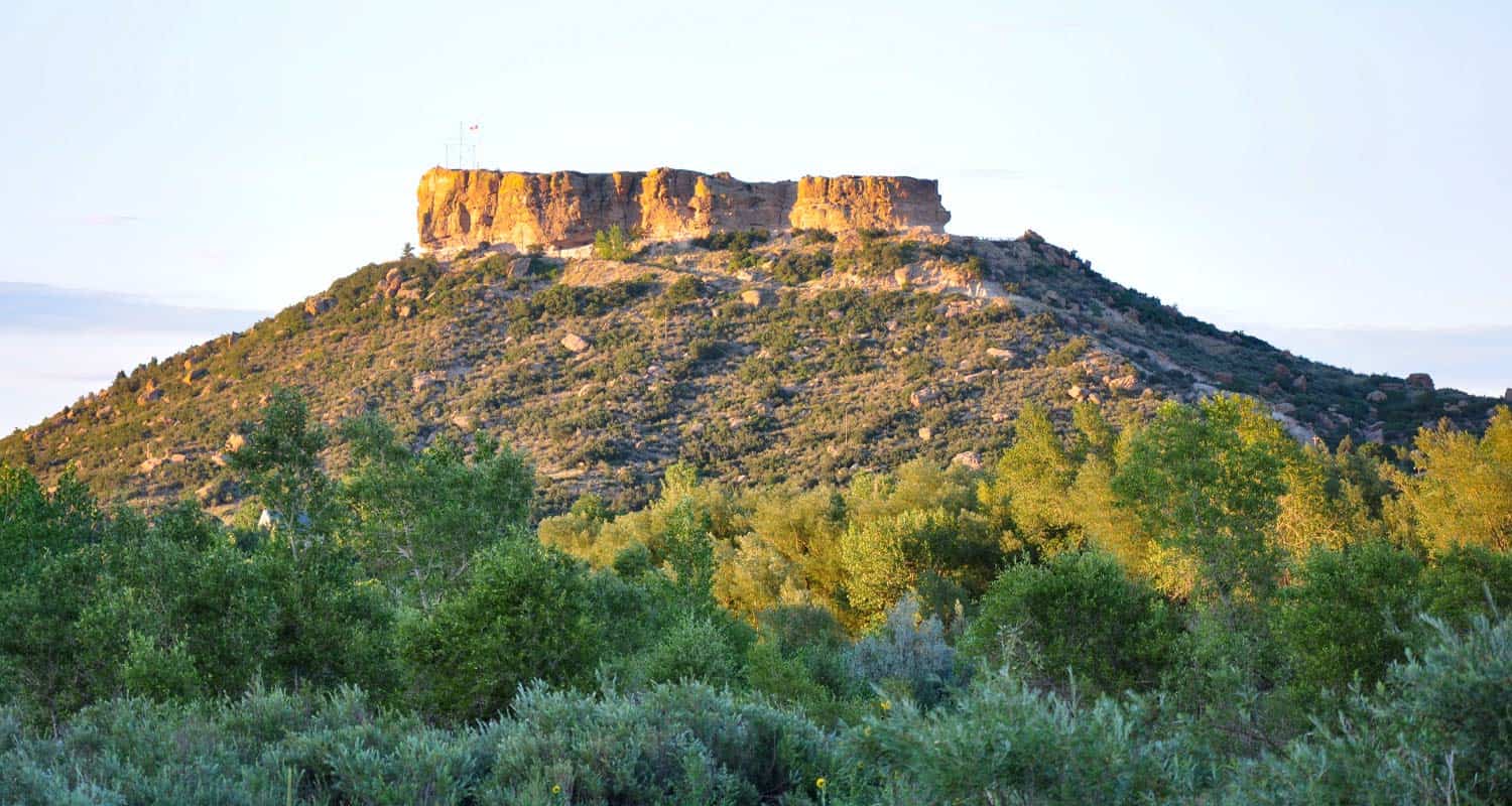
Castle Rock Trail
Rock Park in Castle Rock, Colorado is the trailhead for a 1.4 mile loop within a loop hike that climbs to the base of the town's famous Castle Rock. Click here for the Castle Rock trail map. Explore Dayhikes Near Denver for more hikes in Colorado with impressive rock formations.
Trail Snapshot: Castle Rock Trail
| Hike Distance | 1.4 Miles+Spurs |
|---|---|
| Difficulty | Moderate (can be difficult over rocks) |
| Duration | Approx. 1 hr+ |
| Trail Type | Loop |
| Starting Elevation | 6220' |
| Elevation Gain | Approx. +370' |
| Seasons | All |
| Dogs | Allowed On Leash |
| Hike Trail Map | Click for a Map of Castle Rock Trail |
| Denver Drive Time | 35 min |
| Driving Directions to Castle Rock Trail | Click for Google Map |
| Town Nearest Hike | Castle Rock, Colorado |
| Beauty | Historical monument, rock formations, Front Range views, wildlife: rock squirrels and cliff swallows |
| Activities | Hiking trails, picnic areas, no bikes or horses are allowed |
Tips & Resources for Hiking Castle Rock Trail :
- TIP: There is a panoramic view of Castle Rock at the top. Pike's Peak can be seen to the southwest, and Long's Peak to the northwest.
- TIP: A wide, flat path encircles the rock with a picnic area. Tables are available.
- Trail Map for Castle Rock Trail: Trail Map Link
- Colorado Road Conditions: Colorado Road Conditions
- After the Hike: Crowfoot Valley Coffee
Weather
Map & Driving Directions
Click for Driving Directions

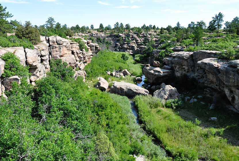
Canyon View Nature Trail at Castlewood Canyon
Castlewood Canyon cuts a unique and green landscape into the plains near Denver. It's not the mountains, but it's worth the drive. Castlewood Canyon State Park has created this beautiful paved trail that follows the canyon rim.
The Canyon Rim Trail also offers an audio tour and is a great way for children to learn more about the plains habitat that covers much of Colorado. Explore this full trail profile for driving directions, trail map, and all the details and tips you'll need to plan your trip to this Colorado State Park.
Trail Snapshot: Canyon View Nature Trail at Castlewood Canyon
| Hike Distance | 1.2 mi (2.4 mi RT) |
|---|---|
| Difficulty | Easy |
| Duration | Approx 1 hr or less |
| Trail Type | Out and Back |
| Seasons | All |
| Dogs | Allowed on Leash in Most Areas, But Not on the East Canyon Trail |
| Hike Trail Map | Click for a Map of Canyon View Nature Trail at Castlewood Canyon |
| Denver Drive Time | 50 min |
| Driving Directions to Canyon View Nature Trail at Castlewood Canyon | Click for Google Map |
| Town Nearest Hike | Castle Rock, Colorado |
| Beauty | Interesting geology, canyon views, interpretive trail, wildflowers, birdwatching |
| Activities | Guided audio nature tour, hiking, picnic areas, visitors center |
| Fee Required | Visit Colorado State Parks Site |
One of the best handicap accessible trails near Denver, the Canyon View Nature Trail at Castlewood Canyon State Park is a 1.2 mile interpretive trail. It runs along the western edge of the top of the canyon and weaves through ponderosa pine and a wonderful variety of wildflowers. The entire trail is a concrete walkway, making the area very accessible to wheelchairs. The trail ends at the Bridge Canyon overlook. Don't miss the view, it's wonderful.
Tips & Resources for Hiking Canyon View Nature Trail at Castlewood Canyon
- TIP: Pick up a brochure so that you can find the various access points for the trail and can take advantage of the side trails.
- Audio Tour: Begin at the visitor's center where you can pick up an audio tour player which guides you through the 5 different ecosystems that are found in Castlewood Canyon.
- Wildflowers: Late June and Early July are the best times to view the wildflowers in Castlewood Canyon.
- Bring Sunscren: Hikes in Castlewood Canyon can be quite exposed to the sun, so bring the sunscreen.
- TIP: Poison Ivy: We've been surprised how poison ivy flourishes in this park, often along the edge of the trail. Know how to identify it, so that you can avoid it. But don't let that deter you from the park. You just need to keep an eye out. See our post on how to identify and treat poison ivy.
- Trail Map for Castlewood Canyon: Trail Map Link
- Additional Maps: Castlewood Canyon State Park Trails
- Colorado Road Conditions: Colorado Road Conditions
- After the Hike: Crowfoot Valley Coffee
Weather
Map & Driving Directions
Click for Driving Directions


Arthur's Rock Trail in Lory State Park
The Arthurs Rock trail in Lory State Park near Fort Collins, Colorado ends with a beautiful panoramic views. You'll pass through meadows, forest, then end your hike with a scramble to the top of Arthur's Rock. Dogs are allowed on a leash, just be sure to bring plenty of water as there are not many places to access drinking water.
| Hike Distance | 3.4 miles RT |
|---|---|
| Difficulty | Moderate |
| Duration | Approx 1 hr 15 min Round Trip |
| Trail Type | Out and Back |
| Starting Elevation | 5600′ |
| Elevation Gain | +1180′ |
| Seasons | Spring to Fall |
| Dogs | Allowed On Leash |
| Hike Trail Map | Click for a Map of Arthur’s Rock Trail in Lory State Park |
| Denver Drive Time | 1 hr 25 min |
| Driving Directions to Arthur’s Rock Trail in Lory State Park | Click for Google Map |
| Town Nearest Hike | Fort Collins, Colorado |
| Beauty | Views of Horsetooth Lake, views of the Front Range, forests, and meadows, wildlife: elk, bobcat, and many bird species |
| Activities | Hiker only trail, but park offers picnic areas, horseback riding, mountain biking, canoeing, & kayaking |
Arthur's Rock History
The place got its name from Arthur Howard who was the one who, along with his brother, Charlie, sold this piece of land. For more information on the history of Arthur's Rock and Lory State Park, visit this page.
Tips & Resources for Hiking Arthur’s Rock Trail in Lory State Park :
- TIP: There is a visitor's center near the Lory State Park entrance.
- TIP: At the summit of Arthur's Rock, there is a beautiful view of Horsetooth Reservoir and the Front Range available.
- Trail Map for Lory State Park: Trail Map Link
- Colorado Road Conditions: Colorado Road Conditions
- After the Hike: The Colorado Room
- Photo: We would like to express our gratitude to Luci Westphal for sharing a great photo of her hike to Arthur's Rock at Lory State Park. Check out her video from this hike.
Weather
Map & Driving Directions
Click for Driving Directions to Lory State Park
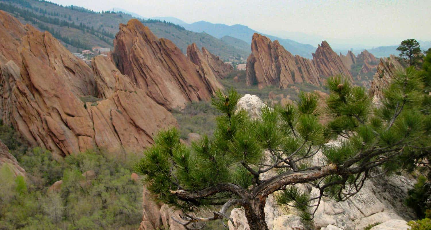
Fountain Valley Trail at Roxborough State Park
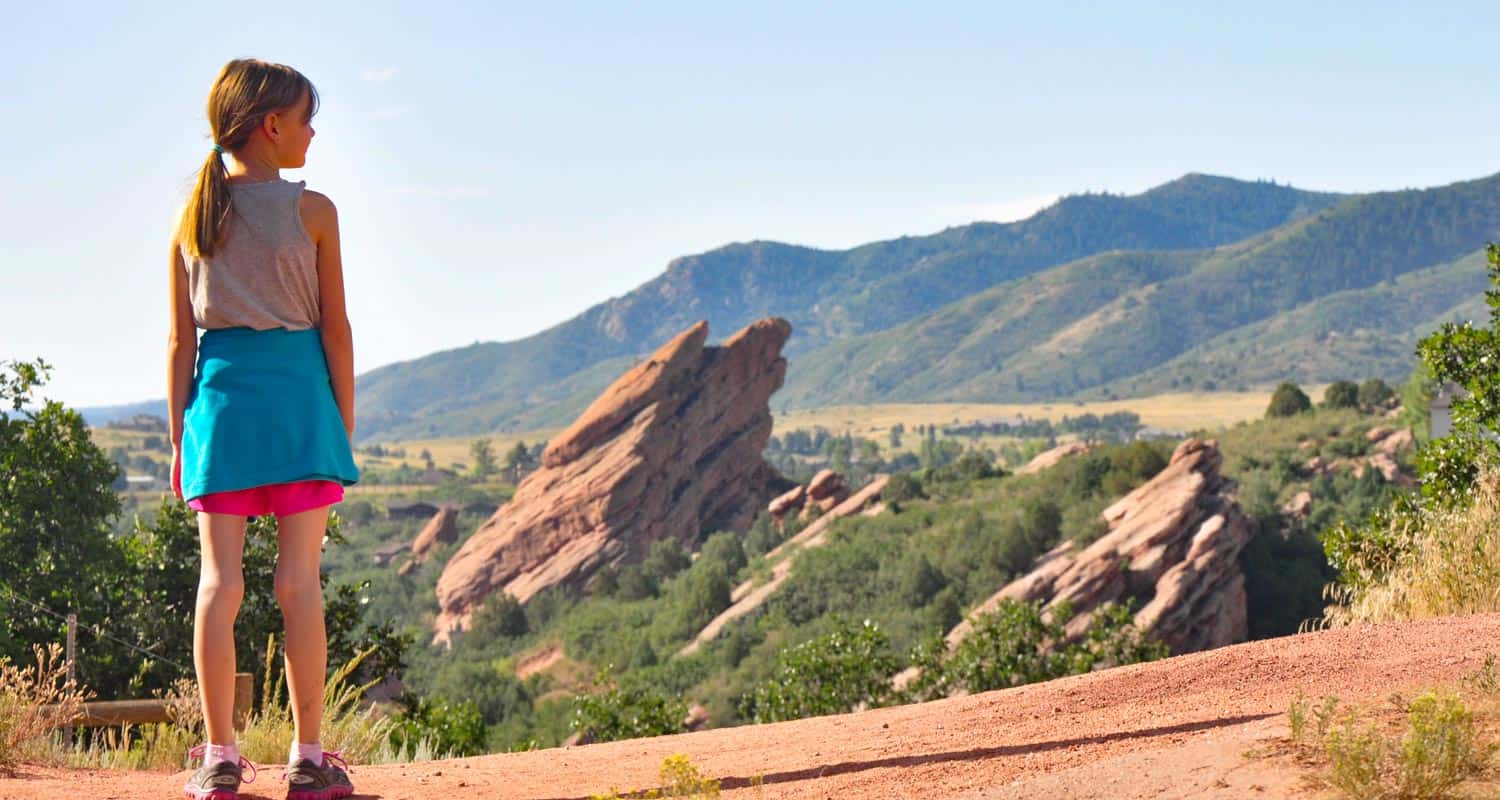
The Fountain Valley trail in Colorado's Roxborough State Park is the Garden of the God's of Denver. It's more secluded than Red Rocks park, and features several trails that take you beyond the park boundaries and into the foothills. The Fountain Valley Trail is a perfect place to start because it features the best part of the park, it's towering slabs of red rock. Explore the hiking profile below for all the trail details, trail map link, and driving directions to the trailhead for this easy Colorado hike.
Trail Snapshot: Fountain Valley Trail at Roxborough State Park
| Hike Distance | 2.3 miles |
|---|---|
| Difficulty | Easy |
| Duration | Approx 1.5 hr |
| Trail Type | Loop |
| Seasons | All Year |
| Dogs | Not Allowed in Roxborough State Park |
| Hike Trail Map | Click for a Map of Roxborough State Park |
| Denver Drive Time | 45 min |
| Driving Directions to Fountain Valley Trail at Roxborough State Park | Click for Google Map |
| Town Nearest Hike | Littleton, Colorado |
| Beauty | Red rock formations, meadows, wildlife: mule deer, eagles, foxes, birds |
| Activities | Hiking, birdwatching, Visitors' Center |
| Fee | Entrance Fee or State Parks Pass Required |
Roxborough State Park is Denver's twin sister of Garden of the God's in Colorado Springs. The beautiful Lyons and Fountain formations climb from the valley floor and create a wonderful space for a quiet hike, birdwatching, and viewing wildlife.
The trail is a loop. You can start on the valley floor, then work your way up to the high trail that looks down and across the fountain formation (photo above was taken from around the midpoint of the high trail). On our visit we encountered several whitetail deer and a variety of birds flitting about in the scrub oak that grows in the valley. The initial part of the trail are handicap accessible, but the trail soon becomes a more narrow dirt trail.
There are some ruins of an old estate along the trail and interpretive signs telling about the history of the valley. We would recommend this trail for families with small children and especially for folks visiting Denver and looking for something fun to do. The low elevation is great for out of towners who may not have the time or capacity to get up into the mountains. Dogs are not permitted, so be sure to leave fido at home. Because this trail is in Roxborough State Park, a fee or Colorado state parks pass is required. See the Roxborough State Park Fees page for details.
Tips & Resources for Hiking Fountain Valley Trail at Roxborough State Park :
- TIP: There is a picnic area with tables just outside the Visitors' Center.
- TIP: Be on the lookout for poison ivy along the sides of the trail. Know how to identify it, so that you can avoid it. But don’t let that deter you from the park. You just need to keep an eye out. See our post on how to identify and treat poison ivy.
- Trail Map for Roxborough State Park: Trail Map Link
- Colorado Road Conditions: Colorado Road Conditions
- After the Hike: Waterton Tavern in Roxborough
- Roxborough State Park Brochure
- Brochure for Roxborough State Park: Brochure Link
Weather
Map & Driving Directions
Click for Driving Directions
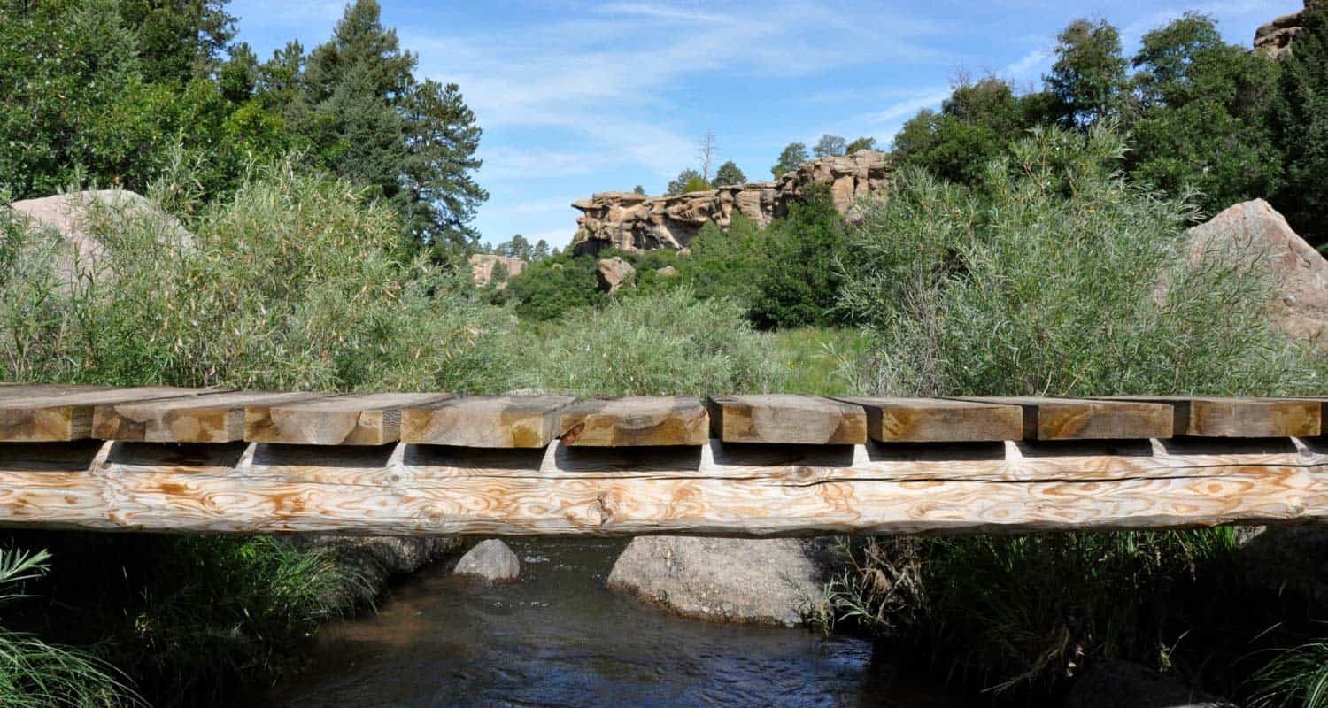
Castlewood Canyon State Park Trails
Because Castlewood Canyon State Park is hidden in the plains--and not the mountains--near Denver, it's often an overlooked State park of Colorado. But, whether you're hiking or rock climbing it's a beautiful and geologically unusual place to explore. It boasts a waterfall, homestead ruins, a stream, caves and clefts, and a lot of fairly easy hikes. Below you'll find more information on how to get to the park, trail map links, and links to several hiking options in Castlewood Canyon.
Trail Snapshot: Castlewood Canyon State Park Trails
| Hike Distance | Less than 1/4 mile to 4 Miles |
|---|---|
| Difficulty | Easy to Moderate |
| Duration | 15 Minutes to 2.5 hours |
| Trail Type | Out and Back and Loop |
| Seasons | Year Round |
| Dogs | Allowed On Leash but not on East Canyon Trail |
| Hike Trail Map | Click for a Map of Castlewood Canyon State Park Trails |
| Denver Drive Time | 50 min |
| Driving Directions to Castlewood Canyon State Park | Click for Google Map |
| Town Nearest Hike | Elizabeth, Colorado |
| Beauty | Meadows, creek, waterfall, interesting geology, canyon views, ruins |
| Activities | Rock climbing, hiking, picnic areas, visitors center |
| Fee Required | Visit Colorado State Parks Site |
Not just a canyon, this Colorado State Park features ruins, a waterfall, and unusual geological formations. The park is riddled with 15 trails, ranging from 1/4 mile to 4 miles, so you have a lot of options. The Canyon View Nature Trail (1.2 miles) is a great example of a handicap accessible trail in Colorado. The East Parking (see map below) offers the most hiking options, while the West Parking area leads to shorter hikes to the Castlewood Canyon climbing areas and the longest (4 mile) East Canyon Trail.
Some Trails In Castlewood Canyon
-
Waterfall Hike at Castlewood Canyon State Park
-
Cliff & Climbers Trail at Castlewood Canyon State Park
-
Homestead Trail at Castlewood Canyon State Park
-
Cave Trail at Castlewood Canyon State Park
-
Canyon View Nature Trail at Castlewood Canyon State Park
- This may be the most accessible waterfall near Denver. A short .17 mile hike from the trailhead. Click on the red link above to go to the waterfall hike trail profile page.
- A short but more demanding hike in Castlewood Canyon where you can explore the crags along the cliffs of the park.
- an easy to medium hike at the west park entrance. Check out the hiking profile to see how to turn this .7 mile trail into a 2 or 4 mile loop hike.
- only a quarter mile round trip up to a small cave in the west side of Castlewood Canyon State park.
- 2.4 mile round trip hike with interpretive signs that takes you along the rim of Castlewood Canyon. One of the best handicap accessible trails near Denver.
Tips & Resources for Hiking Castlewood Canyon State Park Trails:
- TIP: Castlewood Canyon offers some shade, but you are often in the sun. So, bring your sunscreen and apply it liberally.
- TIP: We would also suggest an early morning or sunset hike as these are the best times to observe wildlife.
- TIP: Though it's not the largest of Colorado waterfalls, you'll still hear it before you see it. The waterfall is accessed from Creek Bottom Trail on the West Side of the park.
- TIP: Pets are allowed on a leash but there are some specific trail restrictions, so make sure to read the signs. Enjoy this wonderful hike in the grasslands of Douglas County, Colorado.
- Trail Map: Castlewood Canyon State Park Trails
- Colorado Road Conditions: Colorado Road Conditions
- After the Hike: Crowfoot Valley Coffee
Weather
Map & Driving Directions
Click for Driving Directions
Eldorado Canyon State Park Hikes
Eldorado Canyon State Park is a hiking and climbing Mecca tucked into the Front Range near Boulder and Denver, Colorado. In this hiking profile of Eldorado Canyon, we quickly give you the 4 main trails and some tips for your time in the canyon. Explore the full trail profile below to get all the details.
Trail Snapshot: Hiking In Eldorado Canyon
| Hike Distance | 4 Trails: .5 mile to 3.5 miles (one way) |
|---|---|
| Difficulty | Easy to Moderate |
| Duration | 1-2.5 hrs |
| Trail Type | Out and Back |
| Seasons | Spring, Summer, Fall |
| Dogs | Allowed on Leash |
| Hike Trail Map | Click Here for a Map of Eldorado Canyon State Park |
| Denver Drive Time | 45 min |
| Directions | Click for Google Map |
| Town Nearest Hike | Eldorado Springs, Colorado |
| Beauty | Canyon, Cascades, Cliff Swallows, Cliff-Top Views, Geologic Features |
| Activities | Picnic Areas, Horseback Riding, Mountain Biking, Rock Climbing, Fishing |
| Video | Click For Video |
| Fee | Link to Fees Page |
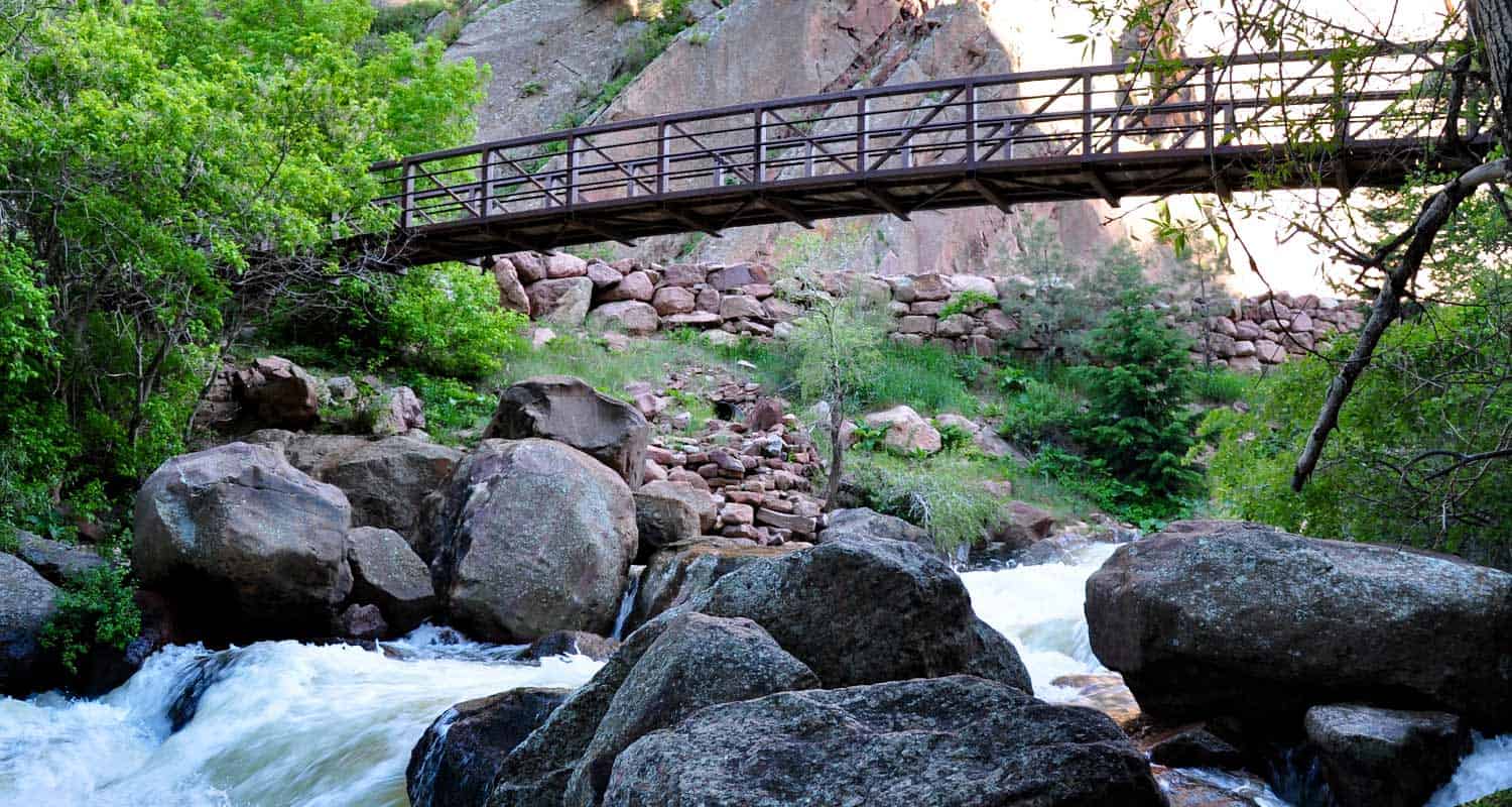
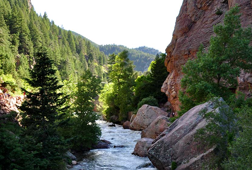
Eldorado Canyon is an oasis just about 45 minutes from Denver. Kids will love hiking over rocks along the streamside trail, peering into caves, and gazing up at the climbers on the towering canyon walls. The park features one of the best picnic areas in the state with shallow areas of boulder creek which quickly fill with kids. Close attention is needed in any situation involving water and children. South Boulder Creek can be swift, especially after rains and during the early melts. During these times, the canyon gushes and roars. The sounds are as great as the views.
Fishing at Eldorado Canyon State Park could potentially yield you fish that are eight inches to an average about eight inches to about twenty inches long. For a more detailed guide on fishing here, check out the one at Colorado Parks and Wildlife here.
There is no camping at Eldorado Canyon State Park, although there are nearby areas to do so.
4 Trail Options in Eldorado Canyon State Park
#1 - The Streamside Trail is the shortest (.5 mile one way) and follows close to the sides of the creek and canyon walls.
#2 - The Fowler Trail takes you .7 miles (one way) and provides great views of the canyon.
#3 - The Rattlesnake Gulch Trail is more difficult, traveling 1.4 miles up to the ruins of the Crags Hotel that burned to in 1912. Another trail goes from the hotel another .8 mile loop and features a view of Colorado's continental divide.
#4 - The Eldorado Canyon Trail is the longest, 3.5 miles (one way), eventually intersecting with the Walker Ranch Loop Trail.
Tips & Resources for Hiking Eldorado State Park:
- Go On a Weekday: Eldorado Canyon is a climbing mecca and can reach capacity on the weekends.
- Picnic: There is a great picnic area at the back of Eldorado Canyon, so pack a lunch or dinner for after the hike.
- Driving Note: Take care in driving through the town of Eldorado Springs, there are many bikers, pedestrians, and pot holes!
- After the Hike: Ozo Coffee in Boulder, Colorado
- Trail Map for Eldorado Canyon State Park: Trail Map Link
- Climbing in Eldorado Canyon
- Colorado Road Conditions: Colorado Road Conditions
Weather
Map & Driving Directions
Alderfer and Three Sisters Park
This park in Evergreen, Colorado, is a family favorite of some of our good friends. They have two young daughters and love to hike Alderfer and Three Sisters. The park has so many trails that the network can get confusing, so download the Alderfer trail map or pick one up at the trailhead.
With over 15 miles of hiking trails, there's something for everyone in this stunning park.
One of the most popular trails in Alderfer Three Sisters Park is the Three Sisters Trail. This challenging 6.4-mile loop takes hikers through dense forests, over rocky terrain, and past stunning vistas of the surrounding landscape. If you're looking for a shorter, easier hike, the Evergreen Mountain Trail is a great option. This 4.8-mile loop offers gentle slopes and gorgeous views of the surrounding mountains.
But hiking isn't the only activity on offer in Alderfer Three Sisters Park. The park also features world-class rock climbing, with dozens of routes for climbers of all skill levels. And if you're looking for a peaceful picnic spot or a place to relax after your hike, the park's many picnic areas and scenic overlooks are the perfect place to unwind.
To make the most of your visit to Alderfer Three Sisters Park, be sure to bring plenty of water and wear sturdy shoes. And don't forget your camera – the views are simply breathtaking! With so much natural beauty to explore, it's no wonder that Alderfer Three Sisters Park is one of Colorado's most beloved hiking destinations.
Trail Snapshot: Alderfer and Three Sisters Park
| Hike Distance | 15 Trails: .2 to 10+ Miles |
|---|---|
| Difficulty | Easy (but consider altitude) |
| Duration | 15 min - 1.5 hrs |
| Trail Type | Loops, Out & Back |
| Starting Elevation | approx. 6500′ |
| Elevation Gain | 0 to approx. +950', depending on the trail |
| Seasons | All |
| Dogs | Allowed On Leash |
| Hike Trail Map | Click for a Map of Alderfer and Three Sisters Park |
| Denver Drive Time | 40 min |
| Driving Directions to Alderfer and Three Sisters Park | Click for Google Map |
| Town Nearest Hike | Evergreen, Colorado |
| Beauty | rock formations, vistas, meadows, ponderosa pine, views of the Continental Divide, Stellar Jays and Coopers hawks |
| Activities | Hiking, climbing, family picnics, mountain biking |
Alderfer Three Sisters Park has an East and West Trailhead.
- Driving Directions to Alderfer Three Sisters East Parking Lot
- Driving Directions to Alderfer Three Sisters West Parking Lot
Alderfer and Three Sisters Park has everything from short, pleasant strolls for the family to more strenuous climbs and a long loop hike.
Some Hike Options at Alderfer and Three Sisters Park
A Short Family Hike:
The Wild Iris Loop (.6 mile loop) is a tame stroll through mountain meadows and can be easily accessed from the west parking lot.
Two hikes that are more strenuous
will take hikers to summit views: Evergreen Mountain East Trail, and the Sisters Trail. The Sisters trail may be the most difficult and most enjoyable in the park. The trail takes you up through three, unusual rock outcroppings and to views down into the quaint town of Evergreen.
A 10+ mile loop hike
can be created by hiking the trails that follow the outer rim of the park. Because the park has so many trails, it's advisable to download the Alderfer Three Sisters Park Map (see link in the above trail snapshot). There are so many options that you'll find it easy to create a hike custom to your visit.
Tips & Resources for Hiking Alderfer and Three Sisters Park:
- TIP: Trail List for 3 Sisters – JeffCo Parks
- TIP: Take a hike to the Brother for a great panoramic view and a place to take pictures.
- Alderfer and Three Sisters Park Map: Trail Map Link
- Colorado Road Conditions: Colorado Road Conditions
- After the Hike: Pizza at Beau Jo's in Evergreen
- Photo: We would like to express our gratitude to Simon Foot for sharing such an amazing photograph of this hike.
Weather
Map & Driving Directions to Alderfer Three Sisters Park
Click for Driving Directions

South Valley Park Trails
The trails of South Valley Park are perfect for an after work hike or run in South Denver. The expansive valley near the neighborhood of Ken Caryl is enclosed on its eastern side by the exposed red rock formations of the hogback and the green foothills to the west. Views to the south are incredible, making South Valley Park especially enchanting during the early morning hours and at twilight.. Explore the full hiking profile below for full trail details, driving directions and more.
Trail Snapshot: South Valley Park Trails
| Hike Distance | 0.5 mile to 3 miles |
|---|---|
| Difficulty | Easy |
| Duration | Approx 1 to 2 hrs |
| Trail Type | Out & Back and Loop |
| Seasons | All Year |
| Dogs | Allowed On Leash |
| Hike Trail Map | Click for a Map of South Valley Park Trails |
| Denver Drive Time | 30 min |
| Driving Directions to South Valley Park Trails | Click for Google Map |
| Town Nearest Hike | Littleton, Colorado |
| Beauty | Red rock formations, meadows, elk, deer, birdwatching, great sunsets |
| Activities | Hiking, horseback riding, mountain biking |
| Video | Click For Video |
Red Rock towers along the eastern wall of South Valley Park and the foothills begin to the west. Almost 1000 acres of meadow and rock offer a near perfect escape from the sounds of the city. The time lapse below shows a great example of a South Valley Park sunrise.
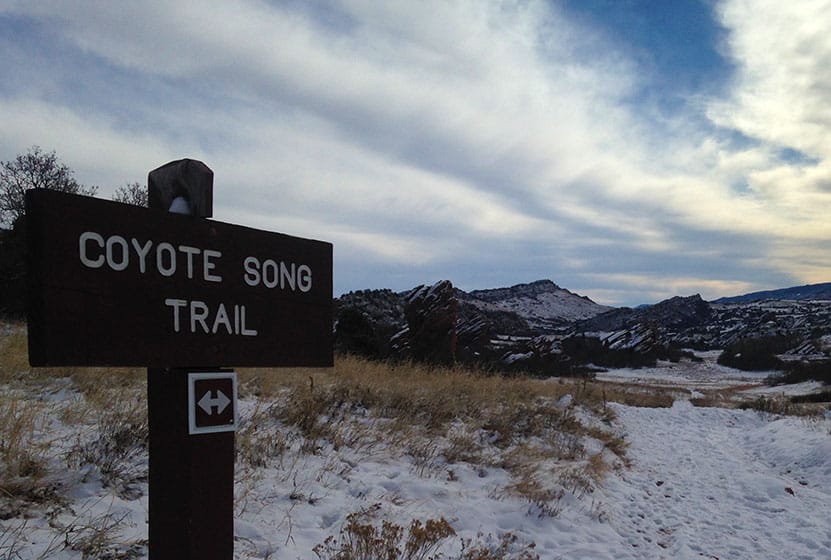
6 Trails wind through the park. The best place to start is with the South Valley Park Coyote Song Trail. It's a an out an back trail that takes you right through the main meadow. It also connects with the Swallow Trail to form a loop, making your hike about 1.8 miles. The Lyons Back Trail takes you from the Coyote Song Trail and up over the red rock where you can hike trails developed by the Ken-Caryl Ranch foundation.
Tips & Resources for Hiking South Valley Park Trails :
- Don't miss the Coyote Song Trail: The sunsets are wonderful and the park tends to be quiet in the evenings. The Coyote Song Trail is a great way to begin or wind down the day.
- TIP: The Parking area on our map link is the larger of the two. However, you can also begin at the south lot off of Deer Creek Canyon Road. Click here for directions. This gives you a closer connection to the Elk Grazing Trail (seasonal) area and Deer Creek Canyon Park.
- TIP: The red rock calls to be climbed, but climbing is prohibited in this park.
- South Valley Park Trail Map: Trail Map Link
- Colorado Road Conditions: Colorado Road Conditions
- After the Hike: Atlas Coffee in Littleton
Weather
Map & Driving Directions
Click for Driving Directions