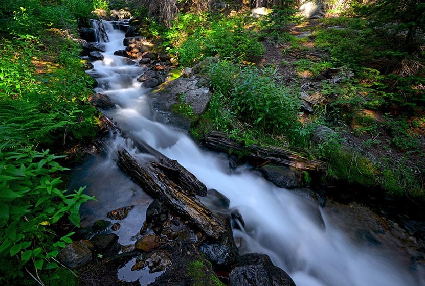
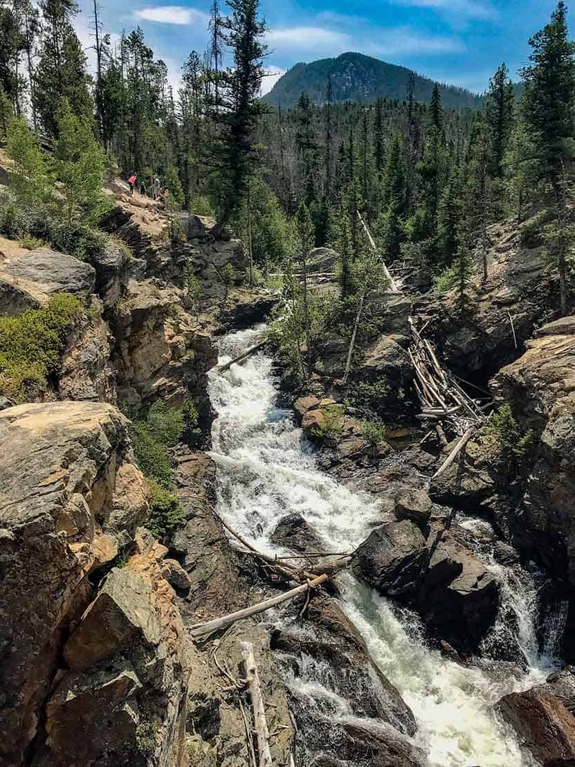
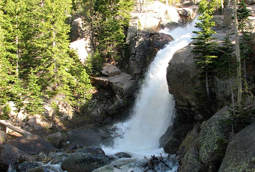
Chaos Canyon Cascades in Rocky Mountain National Park
Chaos Canyon Cascades in Rocky Mountain National Park is formed as Chaos Creek tumbles through the forest below Lake Haiyaha. This 4.2 mile round trip hike is on the east side of RMNP to one of the lesser visited cascade waterfalls in the park. Explore the full Chaos Canyon Cascades hike profile below for trail map, driving directions, and some important tips and resources for this adventure in Rocky Mountain National Park.
Note: Rocky Mountain National Park now requires timed entry permits from May 27th through October 10th. See the RMNP permits page for more information.
Trail Snapshot: Chaos Canyon Cascades in Rocky Mountain National Park
| Hike Distance | 4.2 miles Round Trip |
|---|---|
| Difficulty | Easy to Moderate |
| Duration | Approx 2-3hrs Round Trip |
| Trail Type | Out and Back |
| Starting Elevation | 9475' |
| Elevation Gain | Approx. +700' |
| Seasons | Spring through Fall |
| Dogs | Prohibited in RMNP |
| Hike Trail Map | National Geographic Trails Illustrated Map |
| Denver Drive Time | 2 hr |
| Driving Directions to Bear Lake Trailhead | Click for Google Map |
| Town Nearest Hike | Estes Park, Colorado |
| Beauty | Sub-alpine lakes, mountain views, wildlife: Abert's Squirrel, Elk, Bear |
| Activities | Picnicking, Hiking Trails, Photography |
| Conditions at Bear Lake Trailhead | Click Here |
| Fee | Park Pass Required |
Parking & Trailhead Information for Chaos Canyon Cascades
The trail to Chaos Canyon Cascades begins at the Bear Lake Trailhead (driving directions). In the event the parking lot at Bear Lake is full, you'll then need to park at the Park & Ride near the Bierstadt Trailhead and take the bus into the trailhead. This service runs 7am to 7PM and more information on the RMNP shuttle bus routes can be found at this link. The trail is located on your way to Bear Lake, off to the left, just before reaching the shore viewing area of Bear Lake. It follows the same main trail that leads hikers up to both Nymph and Dream Lakes.
The Hike to Chaos Canyon Cascades
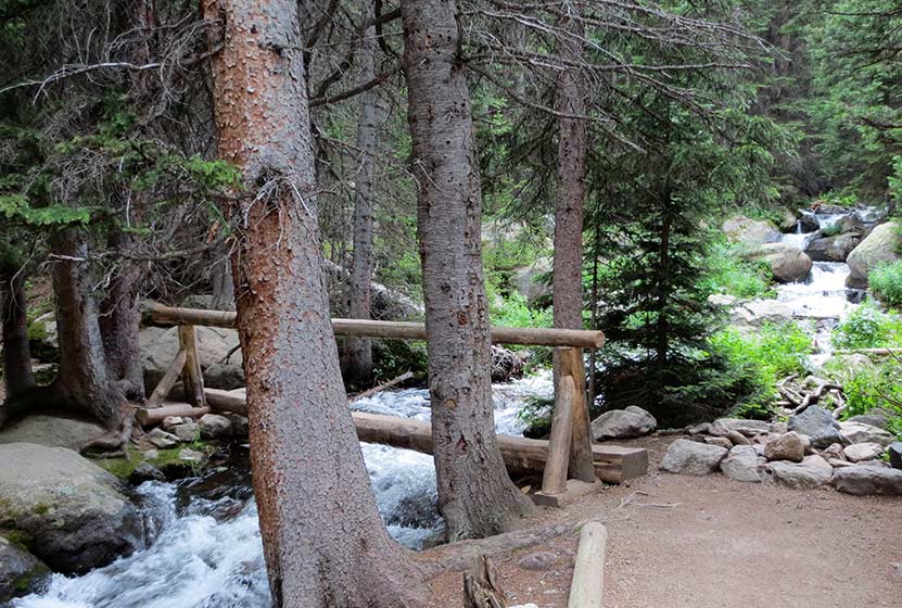
From the Bear Lake Trailhead, hikers will reach Nymph Lake at .5 mile. After continuing on the trail for approximately another .5 mile, hikers will come upon a trail split. Be sure to first hike the additional .1 mile (right-hand trail) up to Dream Lake first. Dream Lake is not to be missed. After returning to this trail split, the trail to Chaos Canyon Cascades is the same trail leading up towards Lake Haiyaha. After traveling .8 mile, the trail crosses a footbridge going over Chaos Creek. After crossing the footbridge, hikers should be able to locate an unmaintained social trail on the left-hand (east) side of the main trail.
The trail will descend and follow Chaos Creek, but will soon enter a steep area where the brush is dense and the trail is difficult to discern. Exercise caution in this area The cascades should come into view after just a few short minutes, as they are only about 1/10th of a mile from the footbridge. Because this is an unmaintained trail, be sure to tread lightly. Take care not to disturb the flowers and undergrowth, and the pristine environment of the cascades.
Hikers can add another Lake to this hike by returning to the main trail via the same route to the cascades, then continuing south to the Lake Haiyaha trail junction. A short spur trail to Haiyaha (on the right) leads to another great high mountain lake in RMNP. Adding Haiyaha to the hike would make this an approximately 4.6 mile round-trip hike.

Tips & Resources for Hiking to Chaos Canyon Cascades in Rocky Mountain National Park
- Explore More: Make this a loop hike and see 4 Lakes and another great Waterfall
- Trail Map for Rocky Mountain National Park: Trail Map Link
- Packing List: Always pack the 10 Essentials. Download our Hiking Guide to get list and dayhiking packing checklist.
- Colorado Road Conditions: Colorado Road Conditions
- Trekking Poles: For most hikes in RMNP--especially if you are traveling on unmaintained trails--we recommend using Trekking Poles. They take a lot of weight off the knees and help in navigating uneven terrain.
- Photo: We would like to express our gratitude to photographer Aaron Cooper for this the photo of Chaos Canyon Cascades. Be sure to check out his extensive gallery of Colorado landscape photography.
- After the Hike: Poppy's Pizza in Estes Park, CO
Weather
Map & Driving Directions
Click for Driving Directions

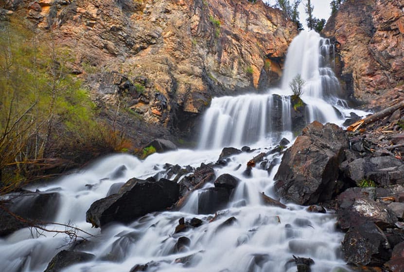
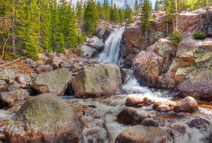
Silver Falls Near Pagosa Springs Colorado
Silver Falls near Pagosa Springs Colorado is an easy hike of less than a quarter mile to a spectacular waterfall. The distance of the drive from Denver requires more than the hike! Explore the full Silver Falls hike profile for driving directions and all the details you need to enjoy this Colorado waterfall trail.
Trail Snapshot: Silver Falls Near Pagosa Springs, Colorado
| Hike Distance | 0.4 mile Round Trip |
|---|---|
| Difficulty | Easy to Moderate |
| Duration | Approx 30 min |
| Trail Type | Out and Back |
| Starting Elevation | 8200′ |
| Elevation Gain | Approx +230′ |
| Seasons | May-September |
| Dogs | Allowed On Leash |
| Denver Drive Time | 5.5 hr |
| Driving Directions to Silver Falls, Pagosa Springs | Click for Google Map |
| Town Nearest Hike | Pagosa Springs, Colorado |
| Beauty | Waterfall |
| Activities | Hiking |
Directions & Trailhead Information for Silver Falls
The parking area for Silver Falls is located about 19 miles from Pagosa Springs along Forest Road 667. Because FR667 is a dirt road, expect washboard and wash areas. The road crosses multiple creeks, and in the late Spring, when the snowmelt is flowing, many of these creeks rise and cover the road. Because of this, it's a good idea to make the drive to the Silver Falls trailhead in a vehicle with higher clearance, such as a truck or SUV. The small parking area is located about 8 miles up 667 on the left-hand side of the road. You'll find an old guard station marking the spot.
The Hike to Silver Falls
The hike up to Silver Falls is short and sweet. It's approximately 1/8th of a mile from the trailhead to the waterfall. The trail starts out easy, then becomes increasingly steep before the emerging from the woods to the spectacular site of Silver Falls. The waterfall plunges first from the orange cliffs above the trail, then tumbles down in a series of dazzling cascades.
Tips & Resources for Hiking Silver Falls, Pagosa Springs, CO
- Visit on a Weekday: This stretch of road is a popular spot for campers and fisherman because of its proximity to the San Juan River. Go on a weekday if you would like to experience solitude and only the sounds of tumbling water.
- Parking: Parking is limited in the small lot. Hikers can also park alongside the road; just be courteous to other drivers and be sure to park in such a way that you don't to get stuck.
- Packing List: Though it's a short hike, you always want to pack the 10 Essentials. Download our Hiking Guide to get list and hiking gear checklist.
- Colorado Road Conditions: Colorado Road Conditions
- Photo: We would like to express our gratitude to Steve Schmickle of Explore the Light Photography for sharing such an amazing photograph of this hike to Silver Falls. I love landscape photography, and Steve's work is my absolute favorite. Check out his gallery and available prints.
- After the Hike: Pagosa Baking Company in Pagosa Springs

Weather
Map & Driving Directions
Click for Driving Directions
Adams Falls in Rocky Mountain National Park
Adams Falls is a short .6-mile round-trip hike near Grand Lake, Colorado. The waterfall borders Rocky Mountain National Park and its trail begins at the same trailhead for the East Inlet Trail. Explore the full Adams Falls hike profile below for trail map, driving directions, and all the details you need for this short waterfall Hike in Rocky Mountain National Park.
Note: Rocky Mountain National Park now requires timed entry permits from May 27th through October 10th. See the RMNP permits page for more information.
Trail Snapshot: Adams Falls in Rocky Mountain National Park
| Hike Distance | 0.6 mile Round Trip |
|---|---|
| Difficulty | Easy |
| Duration | Approx 30 min Round Trip |
| Trail Type | Out and Back |
| Starting Elevation | 8400' |
| Elevation Gain | +79' |
| Seasons | May-September |
| Dogs | Prohibited in Rocky Mountain National Park |
| Hike Trail Map | Click for a Trail Map |
| Denver Drive Time | 2 hr 15 min |
| Driving Directions to Adams Falls, Colorado | Click for Google Map |
| Town Nearest Hike | Grand Lake, Colorado |
| Beauty | Waterfall, East Inlet Creek |
| Activities | Hiking, picnicking, photography |
Adams Falls is named after Jay E. Adams, an early settler of Grand Lake, Colorado. This hike is on the quieter western side of Rocky Mountain National Park. However, it's still a popular trail, so expect to encounter a lot of hikers. Go on a weekday or early morning for the experience of quiet and solitude. After hiking the .3 mile segment of trail, you'll arrive at Adams Falls. There is an observation area that grants the best and safest views of the falls.
The hike to Adams Falls is perfect for families with young children who may not be able to hike as far. As with all streams and waterfalls, have children exercise caution and stay away from the streambank. Rocks are slippery and the hydraulic force of the creek can be incredibly powerful. About 1/4 mile beyond Adams Falls, there are spectacular views of the East Meadows, making the short distance a worth addition to this easy waterfall hike.
Tips & Resources for Hiking to Adams Falls, Grand Lake, CO
- Wear Good Footwear: The trail has a lot of rocks and roots, so be sure to have shoes or boots that can handle slick surfaces.
- Explore More: Hike about a quarter mile past the falls to where the meadows open up and East Inlet creek meanders through the tall grass. It's an amazing sight.
- Trail Map for Rocky Mountain National Park: Trail Map
- Packing List: Always pack the 10 Essentials. Download our Hiking Guide to get list and dayhiking packing checklist.
- Colorado Road Conditions: Colorado Road Conditions
- After the Hike: The Hub Coffee
- Photo: We would like to express our gratitude to Kimon Berlin for sharing such an amazing photograph of this hike.
Weather
Map & Driving Directions
Click for Driving Directions
Ribbon Falls Hike in Rocky Mountain National Park
Ribbons Falls is a slide waterfall that spills from Black Lake in Rocky Mountain National Park. The 4.8 mile hike up to Ribbon Falls is demanding, but well worth the effort as you'll encounter several other waterfalls along the way. Push an additional .2 mile up the trail to Black Lake and yet another waterfall, Black Lake Falls, that seasonally pours down from the heights above Black Lake. Explore the full Ribbon Falls hiking trail profile for trail map, driving directions, and all the details you need to enjoy this adventure in Rocky Mountain National Park.
Note: Rocky Mountain National Park now requires timed entry permits from May 27th through October 10th. See the RMNP permits page for more information.
Trail Snapshot: Ribbon Falls in Rocky Mountain National Park
| Hike Distance | 9.6 miles Round Trip |
|---|---|
| Difficulty | Difficult |
| Duration | Approx 5-6 hrs Round Trip |
| Trail Type | Out and Back |
| Starting Elevation | 9240' at Trailhead |
| Elevation Gain | Approx +1400′ |
| Seasons | May-September |
| Dogs | Prohibited in RMNP |
| Hike Trail Map | Click for a Map of Ribbon Falls in Glacier Gorge |
| Denver Drive Time | 2 hr |
| Driving Directions to Glacier Gorge Trailhead | Click for Google Map |
| Town Nearest Hike | Estes Park, Colorado |
| Beauty | Waterfall, wildlife: elk, deer, marmots; meadows, lakes, streams, wildflowers, aspen trees |
| Activities | Hiking, photography |
| Fee | Park Pass Required |
Parking & Trailhead Information for Ribbon Falls RMNP, Colorado
The trail to Ribbon Fall begins at either the Glacier Gorge Trailhead (see driving directions above), or at the Bear Lake Trailhead (driving directions). Because the Glacier Gorge Trailhead has more limited parking, you may need to drive further up to Bear Lake. There you'll find a short connector trail that will put you on the path to the Glacier Gorge Trail system. In the event that parking at Bear Lake is full, you'll then need to park at the Park & Ride near the Bierstadt Trailhead and take the bus into the trailhead. This service runs 7am to 7PM and more information on the RMNP shuttle bus routes can be found at this link.
The Hike to Ribbon Falls, RMNP
Hiking to Ribbon Falls takes you into the Glacier Gorge Trail system with many wonderful destinations including Mills Lake, Jewel Lake, and further to Black Lake. Review the different waypoints and destinations below so that you don't miss any of the sites. The first destination is at .8 miles, Alberta Falls. After Alberta Falls, the trail ascends toward an eventual trail junction. The way to Ribbon Falls is to follow the Glacier Gorge/Loch Vale trail that bears right. This trail climbs steadily for about another half mile until arriving at a second major trail junction with three options. The left-hand trail leads into Glacier Gorge and eventually up to Ribbon Falls.
List and Links of Destinations From Glacier Gorge Trailhead to Black Lake
1. Glacier Gorge Trailhead
2. Alberta Falls - @ .8 mile
3. Mills Lake - @ 2.8 miles
4. Jewel Lake - @ 3.2 miles
5. Ribbon Falls - @ 4.8 miles
6. Black Lake - @ 5 miles
Jewel Lake - On the Way to Ribbon Falls - Photo Courtesy of J. Gemplar
At Mills Lake, the trail skirts its eastern shore for about half a mile until arriving at Jewel Lake, a much smaller body of water surrounded by lush green marshes. The next segment of the trail is my favorite, a challenging stretch of approximately 2 miles that leads hikers across bogs, and through verdant forest where the snow hangs on well into the summer months. In fact, this stretch may prove very difficult in the spring and early weeks of June--depending on that year's weather. The trail continues to follow Glacier Creek up into the higher reaches of the gorge and ever closer to Keyboard of the Winds, the jagged rock formation ever present against the eastern sky.
Ribbon Falls is located just below Black Lake, on the right-hand side of the trail. It's classified as a slide waterfall. This is just like it sounds: glacier creek flows over a long stretch of orange and pink granite, creating a splash of sound that beckons hikers to stop and take in the view. While it's not the most impressive of waterfalls in Rocky Mountain National Park, it feels like discovering a treasure hidden up in these heights where fewer people choose to go.
From here, you can sit and take in the views, or continue up the trail .2 mile to Black Lake. It may require some careful bouldering to make it over the fortress of rock that holds this high mountain lake. Above Black Lake is another small lake, Frozen Lake, that is hidden from view. In the early weeks of Summer and after rains, a waterfall spills out of Frozen Lake, cascading over the grey rock in a tiered waterfall and eventually making its way into Black Lake.

Tips & Resources for Hiking Ribbon Falls in Glacier Gorge RMNP :
- Start Early: The hike to Ribbon Falls is challenging and hikers will want to begin early to avoid being in this exposed area when afternoon thunderstorms often tear through the area in Summer.
- Trekking Poles in Spring and Winter: Because the trail is high in the mountains, the snow and ice can hang around into late Spring and even early Summer, then pick up again in the Fall. Because of this, we recommend Trekking Poles and/or Traction Devices for this trail when the trail conditions are such.
- Parking: If the parking lot is full at Glacier Gorge Trailhead, there is a shuttle available to take you to the trailhead, or you can park at the Bear Lake Trailhead.
- Rocky Mountain National Park Trail Conditions: Click for RMNP Trail Conditions
- Trail Map for Bear Lake Corridor: Trail Map Link
- Rain Gear Recommended: On every occasion I've been into Glacier Gorge, it's been gorgeous weather--and it rained. So, bring rain gear. In the summer months, thunderstorms can form quickly in this area, especially in the afternoon.
- Packing List: Always pack the 10 Essentials. Download our Hiking Guide to get list and dayhiking packing checklist.
- Colorado Road Conditions: Colorado Road Conditions
- Photo: We would like to express our gratitude to Thomas Mangan for sharing such an amazing photograph of this hike.
- After the Hike: Inkwell Brew Coffee
Weather
Map & Driving Directions
Click for Driving Directions
Black Lake in Rocky Mountain National Park
Black Lake is among the most spectacular lakes in Rocky Mountain National Park. The journey to Black Lake is a strenuous, 10 mile, round-trip hike with significant elevation gain--but both the destination of Black Lake and the several waterfalls along the way make it more than worth the effort. Explore the full Black Lake hiking trail profile for trail map, driving directions, and all the details you need to enjoy this adventure in Rocky Mountain National Park
Note: Rocky Mountain National Park now requires timed entry permits from May 27th through October 10th. See the RMNP permits page for more information.
Trail Snapshot: Black Lake Falls in Rocky Mountain National Park
| Hike Distance | 10 mile Round Trip |
|---|---|
| Difficulty | Difficult |
| Duration | Approx 6 hrs Round Trip |
| Trail Type | Out and Back |
| Starting Elevation | 9240' at Trailhead |
| Elevation Gain | +1430′ |
| Seasons | May-September |
| Dogs | Prohibited in RMNP |
| Hike Trail Map | Click for a Trail Map |
| Denver Drive Time | 2 hr |
| Driving Directions to Glacier Gorge Trailhead | Click for Google Map |
| Town Nearest Hike | Estes Park, Colorado |
| Beauty | Waterfalls, wildlife: elk, deer, marmots; meadows, lakes, streams, wildflowers, aspen trees |
| Activities | Hiking, photography, fishing |
| Fee | Park Pass Required |
Parking & Trailhead Information for Black Lake RMNP, Colorado
The trail to Black Lake begins at either the Glacier Gorge Trailhead (see driving directions above), or at the Bear Lake Trailhead (driving directions). Because the Glacier Gorge Trailhead has more limited parking, you may need to drive further up to Bear Lake. There you'll find a short connector trail that will put you on the path to the Glacier Gorge Trail system. In the event that parking at Bear Lake is full, you'll then need to park at the Park & Ride near the Bierstadt Trailhead and take the bus into the trailhead. This service runs 7am to 7PM and more information on the RMNP shuttle bus routes can be found at this link.
The Hike to Black Lake RMNP
Hiking to Black Lake takes you into the Glacier Gorge Trail system with many wonderful destinations including Mills Lake, Jewel Lake, and Ribbon Falls. Be sure to review the different waypoints and destinations below so that you don't miss any of the sites. The first destination--and one you can't miss because it's right along the trail--is at .8 miles, Alberta Falls. After the waterfall, the trail ascends toward an eventual trail junction. The way to Black Lake is to follow the Glacier Gorge/Loch Vale trail that bears right. This trail climbs steadily for about another half mile until arriving at a second major trail junction with three options. The left-hand trail leads into Glacier Gorge and eventually to Mills Lake.
List and Links of Destinations From Glacier Gorge Trailhead to Black Lake
1. Glacier Gorge Trailhead
2. Alberta Falls - @ .8 mile
3. Mills Lake - @ 2.8 miles
4. Jewel Lake - @ 3.2 miles
5. Ribbon Falls - @ 4.8 miles
6. Black Lake - @ 5 miles
At Mills Lake, the trail follows its eastern shore for about 1/2 a mile until arriving at Jewel Lake, a much smaller body of water surrounded by lush green marshes. The next segment of the trail is my favorite, a challenging stretch of approximately 2 miles that leads hikers across bogs, and through verdant forest where the snow hangs on well into the summer months. In fact, this stretch may prove very difficult in the spring and early weeks of June depending on that year's weather. The trail continues to follow Glacier Creek up into the higher reaches of the park and ever closer to Keyboard of the Winds, the jagged rock formation ever present against the eastern sky.
Keyboard of the Winds is named for the sounds that flow from it's sharp edges as high winds whistle and roar across its peaks. Be sure to stop and listen for the music. It can be a mesmerizing experience.
If snow is still on the ground, then the last bit of the trail may require some basic route finding. The established trail skirts the left/east side of Black Lake, but can at times be hard to find. Stay close to the creek and you should be okay. Soon, hikers will encounter Ribbon Falls, a beautiful slide waterfall. Black Lake is just .2 mile further up the trail. This final segment is steep and requires negotiating some rocks and boulders before coming over the rise to gain breathtaking views of Black Lake.
Tips & Resources for Hiking Black Lake in Glacier Gorge RMNP :
- Start Early: The hike to Black Lake is challenging and hikers will want to begin early to avoid being in this exposed area when afternoon thunderstorms often tear through the area in Summer.
- Trekking Poles in Spring and Winter: Because the trail is high in the mountains, the snow and ice can hang around into late Spring and even early Summer, then pick up again in the Fall. Because of this, we recommend Trekking Poles and/or Traction Devices for this trail when the trail conditions are such.
- Parking: If the parking lot is full at Glacier Gorge Trailhead, there is a shuttle available to take you to the trailhead, or you can park at the Bear Lake Trailhead.
- Rocky Mountain National Park Trail Conditions: Click for RMNP Trail Conditions
- Trail Map for Bear Lake Corridor Trails: Trail Map Link
- Rain Gear Recommended: On every occasion I've been into Glacier Gorge, it's been gorgeous weather--and it rained. So, bring Rain gear. In the summer months, thunderstorms can form quickly in this area, especially in the afternoon--just another reason to begin your hike early.
- Packing List: Always pack the 10 Essentials. Download our Hiking Guide to get list and dayhiking packing checklist.
- Colorado Road Conditions: Colorado Road Conditions
- After the Hike: Inkwell Brew Coffee
- Photo: We would like to express our gratitude to Erik Page for sharing such an amazing photograph of this hike.
Weather
Map & Driving Directions
Click for Driving Directions
Jewel Lake Hike in Rocky Mountain National Park
Jewel Lake is a 6.4 mile round-trip hike into Glacier Gorge in Rocky Mountain National Park. This hike in RMNP takes you first past stunning Mills Lake. Less than half a mile beyond Mills you'll discover Jewel Lake under the shadow of the jagged eastern ridge known as Keyboard of the Winds. Explore the full Jewel Lake hiking trail profile below for trail map, driving directions, and all the details you need to enjoy this adventure in Rocky Mountain National Park.
Note: Rocky Mountain National Park now requires timed entry permits from May 27th through October 10th. See the RMNP permits page for more information.
Trail Snapshot: Jewel Lake in Rocky Mountain National Park
| Hike Distance | 6.4 miles Round Trip |
|---|---|
| Difficulty | Moderate |
| Duration | Approx 3 to 4 hrs Round Trip |
| Trail Type | Out and Back |
| Starting Elevation | 9240' at Trailhead |
| Elevation Gain | Approx. +727' |
| Seasons | May-September |
| Dogs | Prohibited in RMNP |
| Hike Trail Map | Click for a Map of Jewel Lake in Glacier Gorge |
| Denver Drive Time | 2 hr |
| Driving Directions to Glacier Gorge Trailhead | Click for Google Map |
| Town Nearest Hike | Estes Park, Colorado |
| Beauty | Waterfall, wildlife: elk, deer, marmots, moose; meadows, lakes, streams, wildflowers, aspen trees |
| Activities | Hiking, photography, fishing |
| Fee | Park Pass Required |
Parking & Trailhead Information for Jewel Lake RMNP, Colorado
The trail to Jewel Lake begins at either the Glacier Gorge Trailhead (see driving directions above), or at the Bear Lake Trailhead (driving directions). Because the Glacier Gorge Trailhead has more limited parking, you may need to drive further up to Bear Lake. There you'll find a short connector trail that will put you on the path to the Glacier Gorge Trail system. In the event that parking at Bear Lake is full, you'll then need to park at the Park & Ride near the Bierstadt Trailhead and take the bus into the trailhead. This service runs 7am to 7PM and more information on the RMNP shuttle bus routes can be found at this link.
Alberta Falls - Just .8 mile up the trail on your way to Jewel Lake
The Hike to Jewel Lake RMNP
Hiking to Jewel Lake takes you into the Glacier Gorge Trail system with many wonderful destinations including Mills Lake and Ribbon Falls. Be sure to review the different RMNP destinations below to know your options. The first destination--and one you can't miss because it's right along the trail--is at .8 miles, Alberta Falls. After the waterfall, the trail ascends toward an eventual trail junction. The way to Jewel Lake is to follow the Glacier Gorge/Loch Vale trail that bears right. This trail climbs steadily for about another half mile until arriving at a second major trail junction with three options. The left-hand trail leads into Glacier Gorge and eventually to Jewel Lake.
List and Links of Destinations From Glacier Gorge Trailhead to Black Lake
1. Glacier Gorge Trailhead
2. Alberta Falls - @ .8 mile
3. Mills Lake - @ 2.8 miles
4. Jewel Lake - @ 3.2 miles
5. Ribbon Falls - @ 4.8 miles
6. Black Lake - @ 5 miles
Footbridge Across Glacier Creek on the Way to Jewel Lake
At 2.8 miles, hikers will arrive at the edge of Mills Lake. Mills is much larger, and the path to Jewel Lake skirts its eastern shoreline for about 1/2 a mile.
Mills Lake, Shrouded in the Mists of an Afternoon Rainstorm
Jewel Lake is surrounded by extensive marshes, that have a green beauty of their own. Because the foot traffic dies off quite a bit when past Mills Lake, you'll likely find Jewel a quieter spot for a picnic and a good place to fish for brook trout.
Tips & Resources for Hiking Jewel Lake in Glacier Gorge RMNP :
- A Favorite Spot: I've had the chance to spend many weeks backpacking in RMNP, and the Glacier Gorge campsite that is just beyond Jewel Lake is one of the best in the Park. It must be reserved, and only those who call into the backcountry office early in the season get the chance to book it.
- Parking: As always, go early. If the parking lot is full at Glacier Gorge Trailhead, there is a shuttle available to take you to the trailhead, or you can park at the Bear Lake Trailhead.
- Rocky Mountain National Park Trail Conditions: Click for RMNP Trail Conditions
- Trail Map for Bear Lake Corridor: Trail Map Link
- Rain Gear Recommended: On every occasion I've been into Glacier Gorge, it's been gorgeous weather--and it rained. So, bring Rain gear. In the summer months, thunderstorms can form quickly in this area, especially in the afternoon.
- Packing List: Always pack the 10 Essentials. Download our Hiking Guide to get list and dayhiking packing checklist.
- Colorado Road Conditions: Colorado Road Conditions
- After the Hike: Inkwell Brew Coffee
- Photo: We would like to express our gratitude to J. Gempler for sharing such an amazing photograph of this hike to Jewel Lake RMNP.
Weather
Map & Driving Directions
Click for Driving Directions
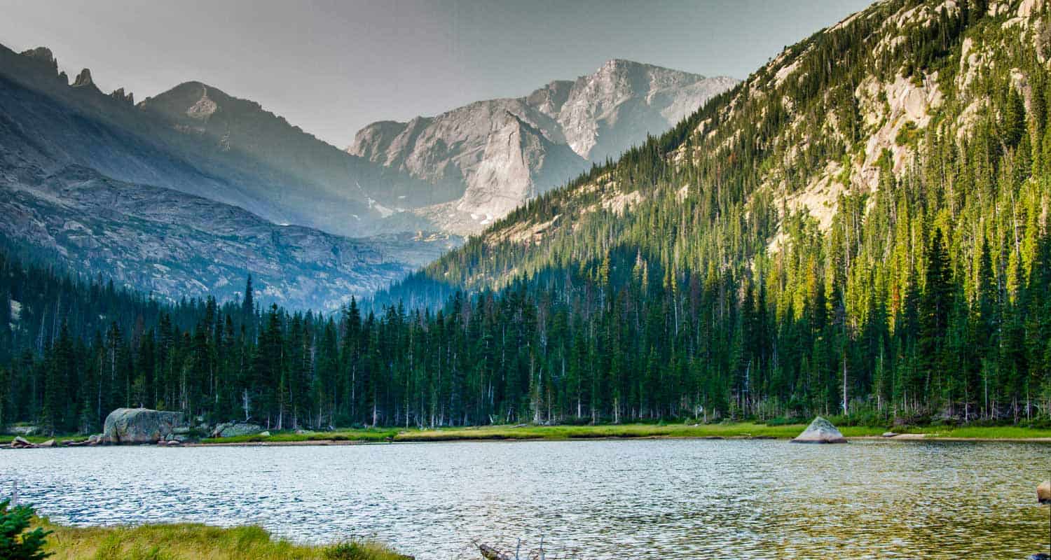
Mills Lake Hike in Rocky Mountain National Park
The hike up to Mills Lake is a steady, uphill, 5.6 mile trek into the breathtaking Glacier Gorge trail system of Rocky Mountain National Park. You'll be entranced by spectacular views of mountain ridges, rugged peaks, and the color of wildflowers along the trail. Glacier Gorge provides surprises at almost every turn. Explore the full Mills Lake hike profile below for trail map, driving directions, and all the details you need to enjoy this adventure in Rocky Mountain National Park.
Note: Rocky Mountain National Park now requires timed entry permits from May 27th through October 10th. See the RMNP permits page for more information.
Trail Snapshot: Mills Lake in Rocky Mountain National Park
| Hike Distance | 5.6 miles Round Trip |
|---|---|
| Difficulty | Moderate |
| Duration | Approx 2-3 hrs Round Trip |
| Trail Type | Out and Back |
| Starting Elevation | 9240' at Trailhead |
| Elevation Gain | +750′ |
| Seasons | May-September |
| Dogs | Prohibited in RMNP |
| Hike Trail Map | Click for a Map of Mills Lake in Glacier Gorge |
| Denver Drive Time | 2 hr |
| Driving Directions to Glacier Gorge Trailhead | Click for Google Map |
| Town Nearest Hike | Estes Park, Colorado |
| Beauty | Waterfall, wildlife: elk, deer, marmots; meadows, lakes, streams, wildflowers, aspen trees |
| Activities | Hiking, photography |
| Fee | Park Pass Required |
Parking & Trailhead Information for Mills Lake RMNP
The trail up to Mills begins at either the Glacier Gorge Trailhead (see driving directions above), or at the Bear Lake Trailhead (driving directions). Because the Glacier Gorge Trailhead has more limited parking, you may need to drive further up to Bear Lake. There you'll find a short connector trail that will put you on the path to the Glacier Gorge Trail system. In the event that parking at Bear Lake is full, you'll then need to park at the Park & Ride near the Bierstadt Trailhead and take the bus into the trailhead. This service runs 7am to 7PM and more information on the RMNP shuttle bus routes can be found at this link.
The Hike to Mills Lake RMNP
The first destination--and one you can't miss because it's right along the trail--is at .8 miles, Alberta Falls. After the waterfall, the trail climbs toward an eventual trail junction. The way to Mills Lake is to follow the Glacier Gorge/Loch Vale trail that bears right. This trail ascends for about another half mile to a second major trail junction with three options. The left-hand trail leads into Glacier Gorge and to Mills Lake.
Mills Lake is one of the fishable lakes in Rocky Mountain National Park. The lake is known to contain rainbow trout, brook trout, and Greenback cutthroats. Most of the high mountain lakes in Rocky Mountain National Park are not completely thawed and warmed up until mid-summer. As a result, you may experience--like I have--some pretty lethargic fish at Mills in the early days of summer.
Photographers will find Mills Lake an equally perfect place to make that big catch. The lake, in the early morning hours, can be placid enough to reflect the backdrop of the beautiful east ridge of Glacier Gorge that has been named, the Keyboard of the Winds.
Tips & Resources for Hiking Mills Lake RMNP :
- Bugs: You might need a bug spray in the summer months when the mosquitos multiply.
- Parking Tip: If the parking lot is full at Glacier Gorge Trailhead, there is a shuttle available to take you to the trailhead, or you can park at the Bear Lake Trailhead.
- Rain Gear Recommended: On every occasion I've been into Glacier Gorge, it's been gorgeous weather--and it rained. So, bring Rain gear. In the summer months, thunderstorms can form quickly in this area, especially in the afternoon.
- Packing List: Always pack the 10 Essentials. Download our Hiking Guide to get list and dayhiking packing checklist.
- Rocky Mountain National Park Trail Conditions: Click for RMNP Trail Conditions
- Trail Map for Bear Lake Corridor: Trail Map Link
- Colorado Road Conditions: Colorado Road Conditions
- Photo: We would like to express our gratitude to Steve Bratman for sharing such an amazing photograph of this hike.
- After the Hike: Inkwell Brew Coffee
Weather
Map & Driving Directions
Click for Driving Directions
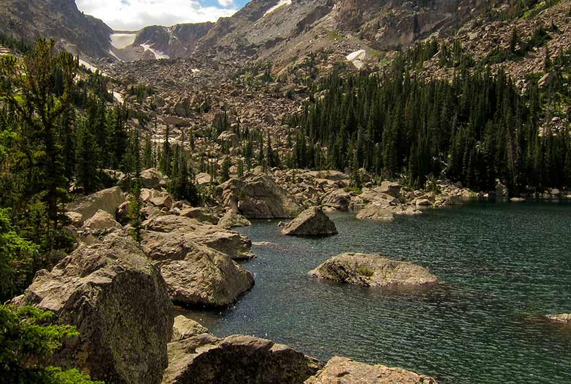
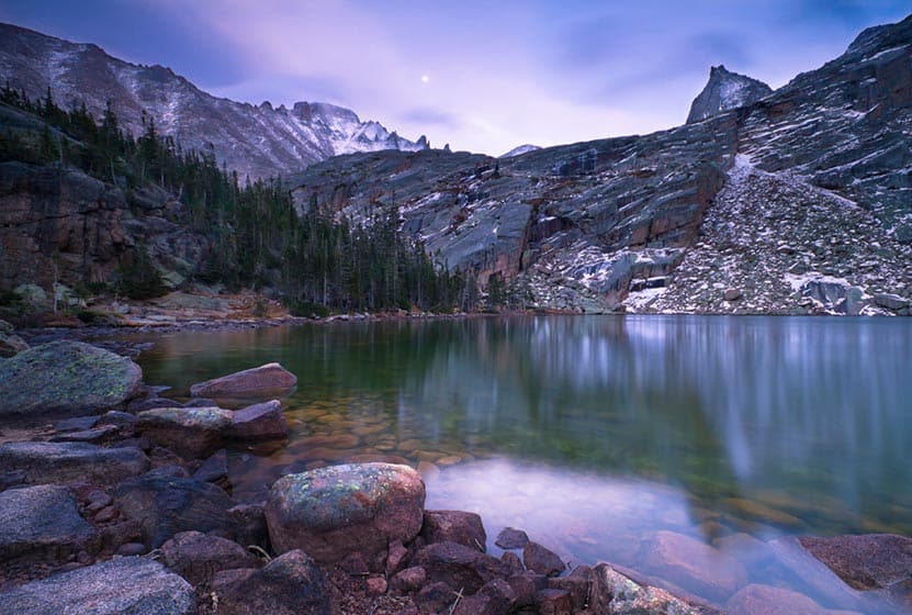
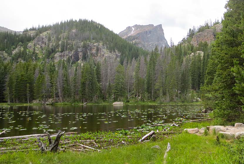
Lake Haiyaha Hike in Rocky Mountain National Park
Lake Haiyaha, in Rocky Mountain National Park, is tucked away in the recesses of a large valley, and its shoreline is surrounded by stacks of massive granite boulders. This relatively easy, 4.2 mile round-trip hike can be a quieter retreat on the busy east side of RMNP, especially if hikers arrive during the early morning hours. Explore the full Lake Haiyaha hike profile below for trail map, driving directions, and all the details you need to enjoy this adventure in Rocky Mountain National Park.
Note: Rocky Mountain National Park now requires timed entry permits from May 27th through October 10th. See the RMNP permits page for more information.
Trail Snapshot: Lake Haiyaha in Rocky Mountain National Park
| Hike Distance | 4.2 miles Round Trip |
|---|---|
| Difficulty | Moderate |
| Duration | Approx 2 to 3 hr Round Trip |
| Trail Type | Out and Back |
| Starting Elevation | 9475' at Trailhead |
| Elevation Gain | Approx. +745' |
| Seasons | Spring through Fall, Winter Snowshoeing |
| Dogs | Prohibited in RMNP |
| Hike Trail Map | Click for a Map of Lake Haiyaha RMNP |
| Denver Drive Time | 2 hr |
| Driving Directions to Bear Lake Trailhead | Click for Google Map |
| Town Nearest Hike | Estes Park, Colorado |
| Beauty | Sub-alpine lakes, mountain views, wildlife: Abert's squirrel, elk, bear |
| Activities | Picnicking, hiking trails, snowshoeing, photography |
| Conditions at Bear Lake Trailhead | Click Here |
| Fee | Park Pass Required |
Lake Haiyaha has become one of my new favorite destinations on the east side of Rocky Mountain National Park. Why, it's got character. The shoreline is more rugged, and the trees surrounding its waters look like ancient sentinels stationed to protect something secret hidden in its depths.
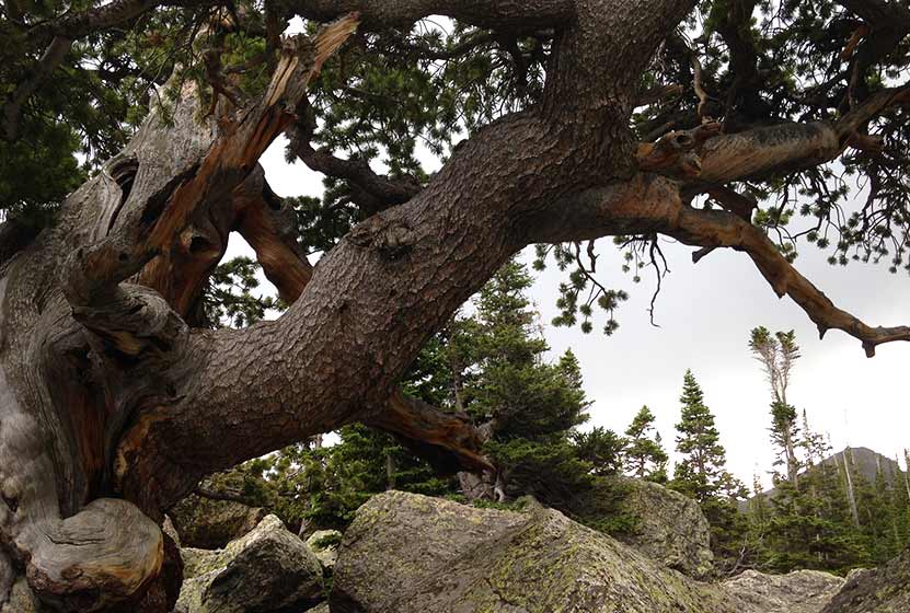
An Ancient Pine at the Boulder-Strewn Gateway to Lake Haiyaha
Parking & Trailhead Information for Lake Haiyaha, Colorado
The trail up to Lake Haiyaha begins at the Bear Lake Trailhead (driving directions). In the event the parking lot at Bear Lake is full, you'll then need to park at the Park & Ride near the Bierstadt Trailhead and take the bus into the trailhead. This service runs 7am to 7PM and more information on the RMNP shuttle bus routes can be found at this link. The trail to Lake Haiyaha is located on your way to Bear Lake, off to the left, just before reaching the shore viewing area of Bear Lake. It follows the same main trail that leads hikers up to both Nymph and Dream Lakes.
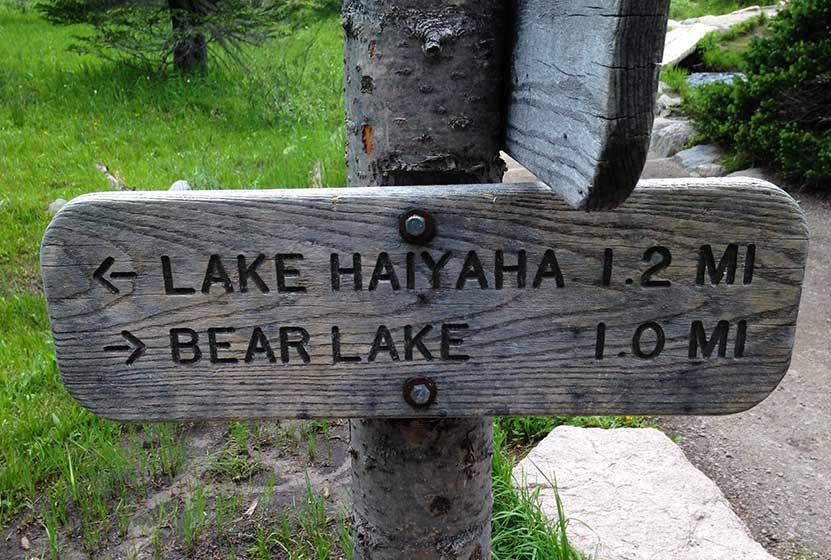
From the Bear Lake Trailhead, hikers will reach Nymph Lake at .5 mile in. After continuing on the trail for approximately another .5 mile, hikers will reach a trail split. Be sure to first hike the additional .1 mile (right-hand trail) up to Dream Lake first, then return to this trail split to take the trail leading another 1.2 mile to Lake Haiyaha. Dream Lake is aptly named and should not be missed. This adds just .2 mile to your total hike.
Here, the trail climbs, zig zagging with switch backs through spruce and fir forest. Out-of-state hikers, who are not acclimated to the altitude, may find this stretch both demanding and tiring. But pushing on to Haiyaha is worth it. Near the lake, the trail makes its way through a maze of boulders, which may require hikers to scramble over them to gain views of the lake. Be gentle with the ancient pines that surround the lake. These have been standing, some for centuries, and are exposed to a lot of human contact. On the way back down the trail, you'll encounter new views. Nymph and Bear Lakes can now be seen from above, giving you a birds eye view of your journey.
Tips & Resources for Hiking to Lake Haiyaha, Colorado
- Explore More: Make this a loop hike and see 4 lakes and one of the RMNP's best Waterfalls - Four Lakes and a Waterfall Loop
- Trail Map for Bear Lake Corridor: Trail Map Link
- Colorado Road Conditions: Colorado Road Conditions
- After the Hike: Poppy's Pizza
- Photo: We would like to express our gratitude to Miguel Vieira for sharing such an amazing photograph of this hike in Rocky Mountain National Park.
Weather
Map & Driving Directions
Click for Driving Directions
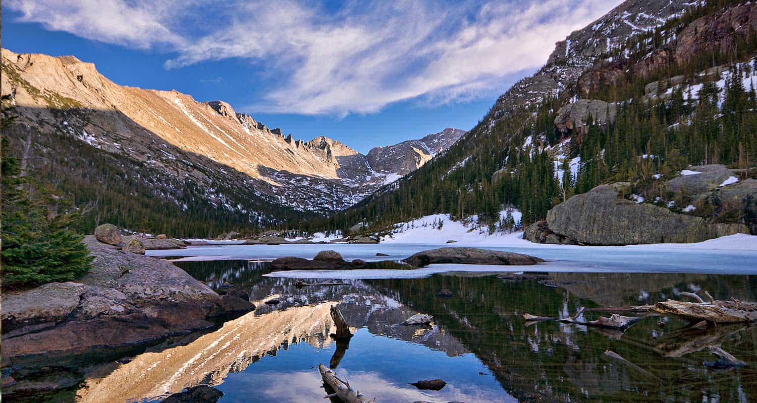
Dream Lake in Rocky Mountain National Park
The hike to Dream Lake is one of the popular destination hikes in Rocky Mountain National Park--and for good reason. In the early morning hours, Dream Lake is a vision straight out of a fairy tale. This 2.2-mile, out-and-back hike begins at the Bear Lake trailhead and passes Nymph Lake along the way. Explore the full Dream Lake hike profile below for trail map, driving directions, and all the details you need to enjoy this Colorado adventure.
Note: Rocky Mountain National Park now requires timed entry permits from May 27th through October 10th. See the RMNP permits page for more information.
Trail Snapshot: Dream Lake in Rocky Mountain National Park
| Hike Distance | 2.2 mile Round Trip |
|---|---|
| Difficulty | Easy |
| Duration | Approx 1.5hr Round Trip |
| Trail Type | Out and Back |
| Starting Elevation | 9475' at Trailhead |
| Elevation Gain | Approx. +425' |
| Seasons | Spring through Fall, Winter Snowshoeing |
| Dogs | Prohibited in RMNP |
| Hike Trail Map | Click for a Map of Dream Lake in RMNP |
| Denver Drive Time | 2 hr |
| Driving Directions to Bear Lake Trailhead | Click for Google Map |
| Town Nearest Hike | Estes Park, Colorado |
| Beauty | Sub-alpine lakes, mountain views, wildlife: Abert's squirrel, elk, bear |
| Activities | Picnicking, hiking trails, photography, snowshoeing |
| Conditions at Bear Lake Trailhead | Click Here |
| Fee | Park Pass Required |
Parking & Trailhead Information for Dream Lake:
The trail up to Dream Lake begins at the Bear Lake Trailhead (driving directions).In the event that parking lot at Bear Lake is full, you'll then need to park at the Park & Ride near the Bierstadt Trailhead and take the bus into the trailhead. This service runs 7am to 7PM and more information on the RMNP shuttle bus routes can be found at this link. The trail to Dream Lake is located on your way to Bear Lake, off to the left, just before reaching the shore viewing area of Bear Lake.
The trail to Dream Lake is paved for the first half mile. The path was surfaced to deal with the erosion caused by the heavy foot traffic, and is not considered handicap accessible. After visiting the lily pad-laden Nymph Lake, the trail becomes a dirt path and begins a gentle climb towards Dream Lake. For a short stint the trail becomes more steep and demanding. On the way up, hikers will gain views of a vast landscape featuring the Keyboard of the Winds in Glacier Gorge and Longs Peak looming over everything but the distant sky.
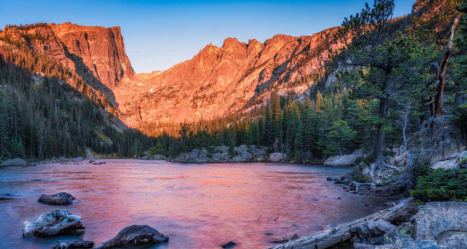
Just before reaching Dream Lake, the trail splits. The trail to the left takes hikers to Lake Haiyaha and the trail to the right leads to Dream Lake. Dream Lake, with the beautiful backdrop of Hallet Peak, is one of the most photographed scenes in Rocky Mountain National Park. At daybreak, light from the east illuminates the stone face and crags of Hallet, and Dream Lake returns the favor by mirroring its image in her waters.
List and Links of Destinations From Bear Lake to Emerald Lake
Tips & Resources for Hiking to Dream Lake:
- Explore More: Adventure beyond Dream Lake is Emerald Lake (+.6 mile from Dream Lake).
- Trail Map for Bear Lake Corridor: Trail Map Link
- Colorado Road Conditions: Colorado Road Conditions
- After the Hike: Poppy's Pizza
- Photo: We would like to express our gratitude to Brendan Bombaci for sharing such an amazing photograph of this hike to Dream Lake.
Weather
Map & Driving Directions
Click for Driving Directions

Nymph Lake Hike in Rocky Mountain National Park
In Summer, Nymph Lake in Rocky Mountain National Park blooms with the yellow blossoms of the lily pads that cover its surface. It's a short easy hike from the Bear Lake Trailhead to Nymph lake. Most hikers will want to make the journey beyond Nymph to Dream and Emerald Lakes. Explore the full trail profile below for all the destinations and details: trail map, tips, and driving directions to the trailhead.
Note: Rocky Mountain National Park now requires timed entry permits from May 27th through October 10th. See the RMNP permits page for more information.
Trail Snapshot: Nymph Lake in Rocky Mountain National Park
| Hike Distance | 1 mile Round Trip |
|---|---|
| Difficulty | Easy |
| Duration | Approx 40 min Round Trip |
| Trail Type | Out and Back |
| Starting Elevation | 9475' at Trailhead |
| Elevation Gain | Approx. +225' |
| Seasons | Spring through Fall, Winter Snowshoeing |
| Dogs | Prohibited in RMNP |
| Hike Trail Map | Click for a Map of Nymph Lake RMNP |
| Denver Drive Time | 2 hr |
| Driving Directions to Bear Lake Trailhead | Click for Google Map |
| Town Nearest Hike | Estes Park, Colorado |
| Beauty | Sub-alpine lakes, mountain views, wildlife: Abert's squirrel, ducks, bear |
| Activities | Picnicking, hiking trails, snowshoeing |
| Conditions at Bear Lake Trailhead | Click Here |
| Fee | Park Pass Required |
Parking & Trailhead Information
The trail up to Nymph Lake begins at the Bear Lake Trailhead (driving directions).In the event that parking lot at Bear Lake is full, you'll then need to park at the Park & Ride near the Bierstadt Trailhead and take the bus into the trailhead. This service runs 7am to 7PM and more information on the RMNP shuttle bus routes can be found at this link. The trail to Nymph Lake is located on your way to Bear Lake, off to the left, just before reaching the shore viewing area of Bear Lake.
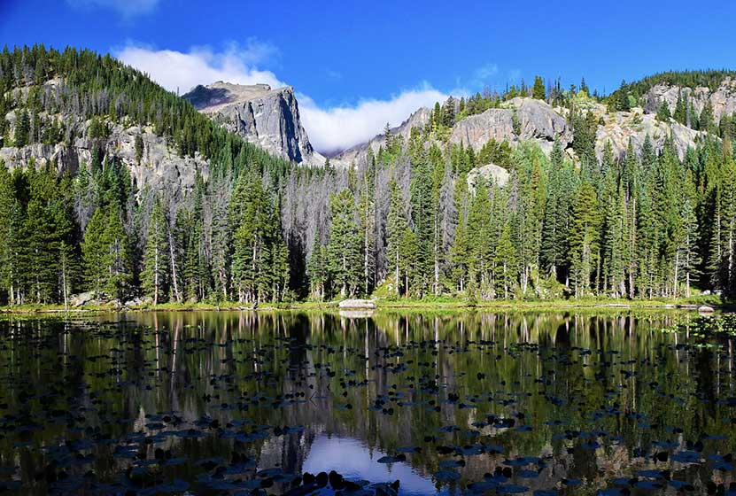
The hike up to Nymph Lake is one of the least demanding--but still rewarding--destinations in Rocky Mountain National Park. Most hikers make the Lake a stopping point on their journey on the longer, 3.6 mile round-trip hike to Emerald Lake. However, Nymph Lake is not without its attractions. In the summer, after the snow and ice have melted, the yellow pond lily fills the lake and bursts with yellow blooms. In the Winter, the Lake, being a smaller body of water (less than 1/5th the size of Dream Lake), freezes over, and Park Rangers will lead snowshoers across it's frozen waters.
The half-mile trail from Bear Lake to Nymph has been improved with asphalt. However it's not exactly wheelchair accessible. The trail was paved in order to absorb the impact of the numerous visitors who hike from Bear Lake to Nymph lake every day. The asphalt ends at Nymph and returns to a dirt trail, meandering through the woods to Dream and Emerald Lakes. At the Lake, hikers can take in some of the iconic scenery of Rocky Mountain National Park. Hallet Peak and Flattop Mountain loom in the distance. Go early in the morning for the most best photography opportunities, and be sure to explore the trail profiles below for the beautiful destinations beyond Nymph Lake.
List and Links of Destinations From Bear Lake to Emerald Lake
1. Bear Lake
2. Nymph Lake - @ .5 miles
3. Dream Lake - @ 1.1 miles
4. Emerald Lake -@ 1.8 miles
Tips & Resources for Hiking to Nymph Lake :
- Explore More: Beyond Nymph lake, you'll find Dream lake (+.6 mile) and Emerald Lake (+.6 mile from Dream Lake).
- Trail Map for Bear Lake Corridor: Trail Map Link
- Conditions at Bear Lake: Click to View Current Conditions
- Colorado Road Conditions: Colorado Road Conditions
- Photo: We would like to express our gratitude to Pete Sheffield for sharing such an amazing photograph of this hike.
- After the Hike: Poppy's Pizza
Weather
Map & Driving Directions
Click for Driving Directions