Hiking Green Mountain Near Boulder
Green Mountain in Boulder, Colorado is a strenuous hike that offers fantastic views of the Front Range, Flatirons, and a wide panorama at the top of Green Mountain. The trails around Chautauqua park offer a several options to summit Green Mountain, letting you take your trail of choice, but in the trail profile below, we'll point out the most direct route. Explore the full Green Mountain hike profile below for trail map, driving directions, and all the details you need to conquer this hike near Boulder.
Trail Snapshot: Green Mountain via Gregory Canyon Trail
| Hike Distance | 5.5 miles |
|---|---|
| Difficulty | Difficult |
| Duration | Approx 3 to 4 hrs |
| Trail Type | Loop with Spur to Summit |
| Elevation Gain | +2500′ |
| Seasons | All Year |
| Dogs | Allowed on Leash (see details in tips below) |
| Hike Trail Map | Click for a Map of Green Mountain |
| Denver Drive Time | 40 min |
| Directions | Click for Google Map |
| Town Nearest Hike | Boulder, Colorado |
| Beauty | Panoramic views at the peak, wildflowers, shade, lots of wildlife |
| Activities | Hiking, Picnicking, Trail Running |
| Video | Click For a Video of Green Mountain |
Green Mountain Near Boulder Trail Profile
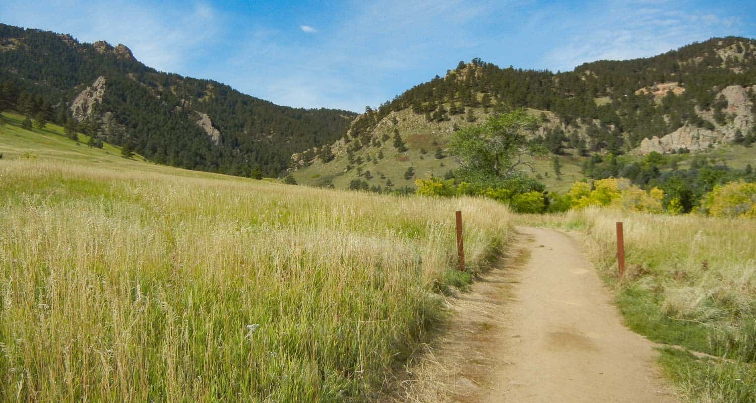
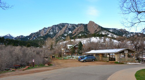
Parking was EXTREMELY busy when I visited on a Sunday morning, I had to park along Baseline road and many people were parking along residential streets. Don’t be turned off by this though, many come for the lower hikes, and visitors noticeably thin off as soon as you enter Gregory canyon to make your way up to the summit of Green Mountain. Gregory Canyon has its own trailhead parking area which requires a fee.
The 2013 flooding has closed the Gregory Canyon parking lot, but it's a small lot anyway and most hikers will need to park along the road as I did--unless you plan to hit the trail before 7am. You can also begin your hike at Chautauqua park, and take the ski jump trail to the bluebell trail which will lead you to the Gregory Canyon trailhead. This will add 1.2 miles round trip to your hike, but will afford you great views of the Flatirons at the beginning of the hike.
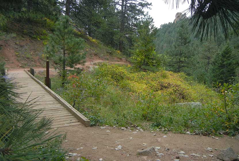
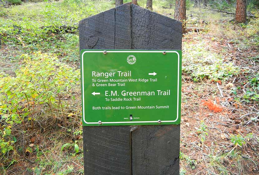
Another option is to park along Flagstaff road near Realization Point, and to completely bypass Gregory Canyon and take only the Ranger Trail up. However, this trail profile of Green Mountain will feature a loop hike taking the following trails: Gregory Canyon to the Ranger Trail to the Summit, returning via the E M Greenman trail, then back down via Saddle Rock for a total of around a 5.5 mile hike. See the map link above to get a visual of the route.
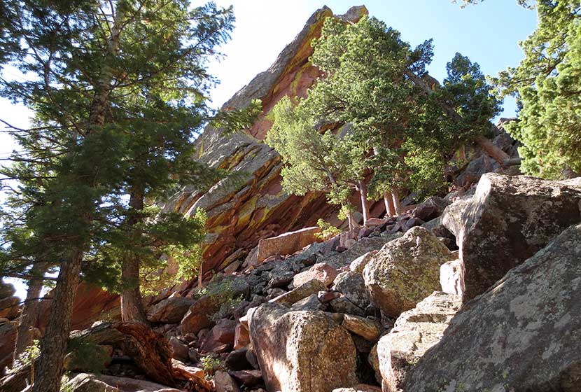
Starting at the Gregory Canyon trailhead, you'll notice that the first portion of the hike is very sun exposed. However, the Gregory canyon and Ranger and Greenman trails are probably ~80% shaded. There is some flood damage from 2013 floods, but the trail markings have been updated and are very clear (just make sure you read all posts at each intersection). The Gregory Canyon trail, like many others in the Chautauqua park area, has an orchard-like aroma because of all the flowers and fruit growing along the trail.
I noticed several families with children hiked Green Mountain from the Flagstaff Rd parking area, but noted that the smaller kids had to be carried at some points.
For Summiting Green Mountain you have two choices, Ranger or Greenman. Ranger has more carved steps and is mostly switchback in nature. Greenman seems to be fewer switchbacks, in favor for a more gentle climb. For this loop hike, take the Ranger trail up, and descent via the Greenman trail.
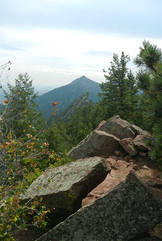
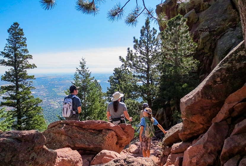
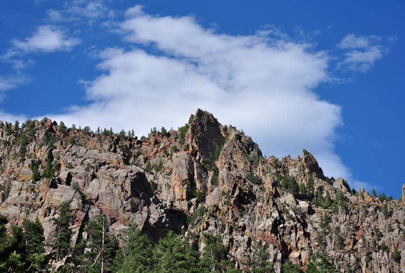
At The Summit of Green Mountain
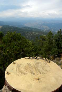
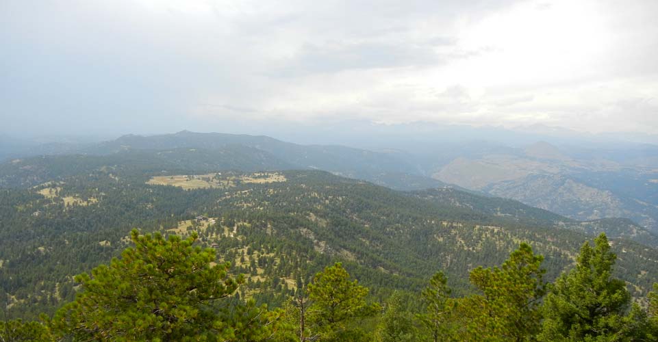
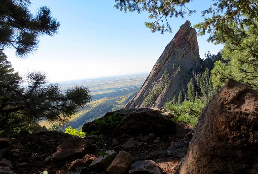
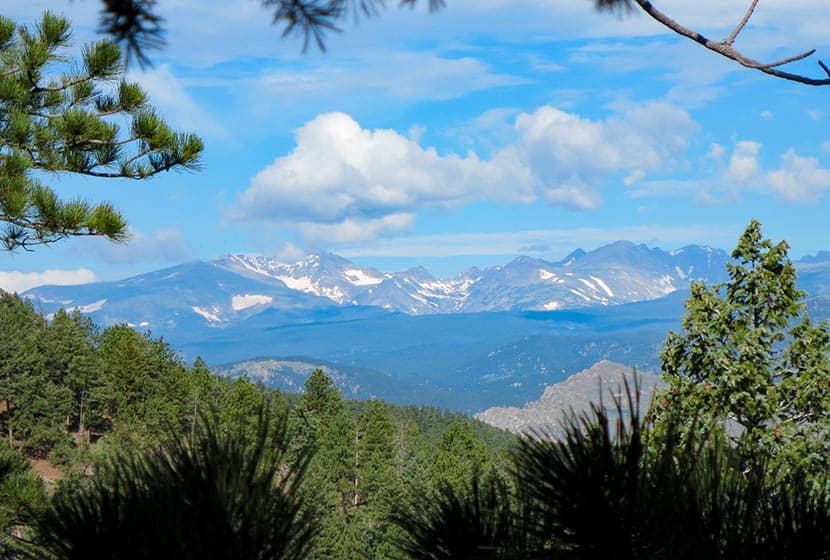
The summit of Green mountain gives you a panorama view to both into Boulder in the East, and to the Rocky Mountains in the West. There is a unique bronze disk set into the granite at the summit. It points out and identifies the different peaks in the distance. Most of the year, except in July through most of September, you'll be able to take in the snow-capped ridges and peaks of the Indian Peaks Wilderness area.
The Return Hike Down Green Mountain
Of course, you could descend the way you came, but why not take in some new trails and views. You can make this a loop hike by descending the Greenman trail. After about 1 mile, the trail will intersect with the Saddle Rock Trail. Take the Saddle Rock Trail back down to the Gregory Canyon Trailhead.
We want to thank Joe Quintana, a member of our Dayhikes Pathfinder Team, who hiked Green Mountain, gathered the information for the trail profile, wrote portions of this post, and took the photos for this hike. Thanks, Joe!
Tips & Resources for Hiking Gregory Canyon to Green Mountain:
- Parking: Parking area was closed due to 2013 flooding. Trailhead is only accessible by hiking up Baseline trail from a lower parking area.
- poison ivy: There is poison ivy along the Gregory Canyon trail, so be sure to be careful not to brush up against it.
- dogs: Boulder's parks allow approved dogs to be off-leash, but owners must get a voice and sight control tag. For more information, see Boulder's dog voice and sound control tag page.
- Hiking Guide: Be sure to download our Dayhike Hiking Guide and Packing Checklist so that you are prepared for this strenuous hike.
- After the Hike: Etai's cafe in Boulder
- Road Conditions: Colorado Road Conditions
- Trail Map for Chautauqua Area: Trail Map Link
Weather
Map & Driving Directions
Click for Driving Directions

Horseshoe Trail at Golden Gate Canyon Park
The Horseshoe Trail in Golden Gate Canyon State Park is a wonderful hike for older kids, experienced and non-experienced hikers. It's a great trail for spotting wildlife, from birds to deer, viewing fall colors and wildflowers, and taking in the beautiful scenic view along the trail. Several of the backcountry campsites areas are also accessible from the Horseshoe trail. We'll detail those locations, provide links to a trail map, driving directions and more in the trail profile on this Colorado hike.
Trail Snapshot: Horseshoe Trail at Golden Gate Canyon Park
| Hike Distance | 3.6 miles Round Trip |
|---|---|
| Difficulty | Moderate |
| Duration | Approx 2 hr |
| Trail Type | Out and Back |
| Elevation Gain | +910′ |
| Seasons | Spring through fall, depending on snow fall |
| Dogs | Allowed on Leash |
| Hike Trail Map | Click for a Map of Golden Gate Canyon Park |
| Denver Drive Time | 50 min |
| Directions | Click for Google Map |
| Town Nearest Hike | Golden, Colorado |
| Beauty | Wildflowers, spruce and fir trees, aspen meadows, big boulders, wildlife, mountain views and running stream along trail |
| Activities | Hiking only trail |
| Video | Click For a Video of Golden Gate Canyon Park |
| Pass Required | Daily Pass Link Annual State Parks Pass Link |
Golden Gate Canyon's Horseshoe Trail is a 3.6 mile out-and-back hike (1.8 miles one-way). We've rated it as moderate in difficulty because of the 900+ feet of elevation gain. The Horseshoe Trail is popular because it follows the beds of several small streams, winds through groves of aspen trees, and leads to beautiful meadows, as well as three of Golden Gate Canyon State Park's backcountry camping areas.
To get to the trailhead (first,use our driving directions). Once in the park, exit to the right out of the Visitors Center--you'll want to stop here first to pick up a map. You'll find the Frazer Meadows parking area and trailhead for the Horseshoe Trail on the left-hand side of the road. Keep in mind that parking is limited, so it would be best to arrive early. There are also restrooms at the Horseshoe trail trailhead and we found them to be kept up and clean.
One of the highlights of this trail are the streams that run along it. You'll find that there are several small bridges to cross as you make your way up the trail. Seasonal streams also mean that sections of the Horseshoe trail will get muddy on after rains and during the Spring melt-water runoff. But water also means wildflowers, and this trail comes alive with them in late Spring through the Summer.
The Horseshoe Trail also leads you to access trails for three of the five Golden Gate Canyon backcountry camping areas. Use this link to the backcountry camping brochure to get details on cost per night and how to make campsite reservations in Golden Gate Canyon State Park. The first campsite access trail is at 1.1 miles and will take you to Greenfield Meadows, which has 4 campsites. Continuing on the same spur, you can hike further in to the Frazer Meadow campsite which has 4 campsites and one backcountry shelter. If you continue on the Horseshoe trail, you'll come upon the access trail for Rim Meadow campsite at 1.3 miles. Rim Meadow also has 4 campsites.

Tips & Resources for Hiking the Horseshoe Trail:
- Park Pass: A Colorado State Park Pass is required to enter Golden Gate Canyon State Park. Check the Golden Gate Canyon Fees page for details on park passes. Some trails offer passes at self-serve dispensers.
- Printed map: The trail forks to the left, make sure to have a printed map on hand which you can pick up at the Visitors Center.
- Bug spray: for hot summer days not a bad idea.
- Sun protection: The trail is often shaded--a rare thing for Front Range hikes--but be sure to bring sun protection because it is almost 4 miles round trip and there are areas exposed to the sun.
- No cell phone: There is no cell phone coverage at Golden Gate Canyon State Park.
- Download our Dayhikes Hiking Guide for a day hike packing checklist
- After the Hike: Windy Saddle Cafe in Golden
- Road Conditions: Colorado Road Conditions
- Trail Map for Golden Gate Canyon State Park: Trail Map Link
A big thanks goes out to Lisa Palmer, a member of our Dayhikes Pathfinder Team, who hiked this trail with her family, gathered the information for the trail profile, and took the photos for this post.
Weather
Map & Driving Directions
Click for Driving Directions
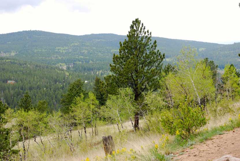
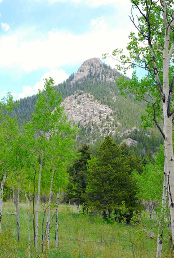
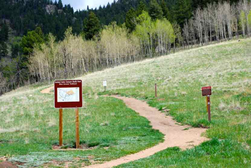
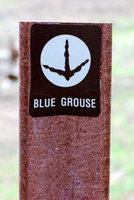
Blue Grouse Trail at Golden Gate Canyon Park
The Blue Grouse Trail is a short, 1.6-mile hike on the western edges of Golden Gate Canyon State Park. A pleasant trail with little gain in elevation and mellow terrain makes this a great escape from the city. The Blue Grouse Trail is a perfect hiking trail for spotting wildlife, from birds to deer, viewing fall colors and wildflowers, and taking in the beautiful scenic view along the trail. Explore the full hiking trail profile below for hike details, trail map, and links to similar trails near Denver.
Trail Snapshot: Blue Grouse Trail
| Hike Distance | 1.6 mile RT |
|---|---|
| Difficulty | Easy to Medium |
| Duration | Approx 1 hr |
| Trail Type | Out and Back |
| Elevation Gain | Approx. +400' |
| Seasons | All Year, depending on snow fall |
| Dogs | Allowed on Leash |
| Hike Trail Map | Click for a Map of Blue Grouse Trail |
| Denver Drive Time | Approx. 1 hr |
| Directions | Click for Google Map |
| Town Nearest Hike | Golden, Colorado |
| Beauty | Wildflowers, pine and spruce trees, aspen meadows, big boulders, wildlife, mountain views |
| Activities | Hiking, mountain biking, horseback riding (permitted on trail), Fishing at Kriley Pond (permit required) |
| Pass Required | Daily Pass Link Annual State Parks Pass Link |
| Video | Click For a Video |
Before you start this hike there are some things you should know - a Colorado State Park Pass is required to enter Golden Gate Canyon State Park. A day pass can be purchased at the Visitors Center upon entrance into the park. Some trails offer passes at self-serve dispensers, but the Blue Grouse Trail does not.
To get to the Blue Grouse trailhead, pass Kriley Pond and take the first right at Mountain Base Road. The trailhead parking area is to the right at the fork in the road. At the trailhead you’ll find picnic tables. There is a porta-let at Kriley Pond and there are restroom facilities at the Visitors Center. Below you'll find more details on the trail, Kriley pond, and some information on camping at Golden Gate Canyon State Park.
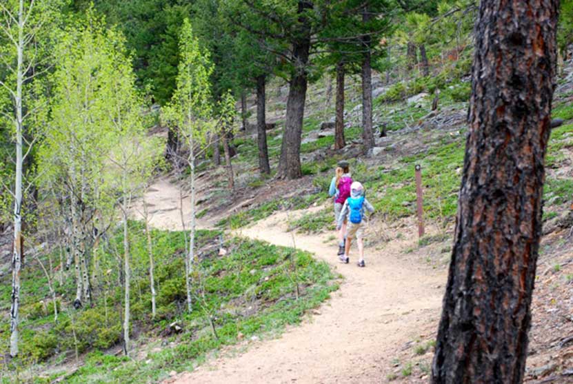
Hiking the Blue Grouse Trail
You'll make your way along a nice dirt path with a few rocky sections. The elevation gain is slight, and this short hike can be turned into a longer one by joining up with the Mule Deer Trail where the Blue Grouse trail terminates at .7 mile. Mule Deer Trail is a 7.4 mile loop, and there is a Golden Gate Park map at the trail intersection.
The Blue Grouse Trail is a popular trail for mountain bikers who use it to access the longer trails in Golden Gate. Mountain bikers in Colorado are typically very considerate of hikers, but just be aware that you'll be sharing the trail with others. After the initial rise, the trail is more gentle as it ascends the hillside. You'll be drawn to the rock outcroppings ahead and a beautiful grove of aspens.
Tips & Resources for Hiking the Blue Grouse Trail:
- Trail options: View the Golden Gate Canyon Park map to see the various other trail options you have after hiking the .7 mile in on Blue Grouse.
- Rim Meadows: a great destination if you would like to continue on the Mule Deer Trail but are not wanting to hike the entire Mule Deer trail loop.
- Picnic: Because Golden Gate Canyon State Park is an hour drive, make a half-day or full-day out of your trip. Bring a picnic, and sling up a hammock for a nap in the shade.
- Download our Dayhikes Hiking Guide for a day hike packing checklist
- Sun protection: The trail is only partly shaded, so be sure to bring sun protection for the parts not covered.
- After the Hike: Buffalo Moon Coffee
- Road Conditions: Colorado Road Conditions
- Trail Map for Blue Grouse Trail: Trail Map Link
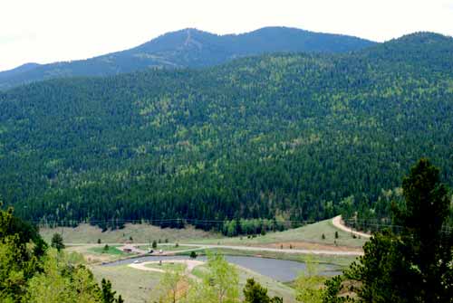
Kriley Pond at Golden Gate Canyon State Park
Kriley Pond is a popular fishing spot in Golden Gate Canyon State Park. In the fall, the hillsides are peppered with the golden glow of Aspens.The early morning hours are the best time to visit if you want to soak in the songs of Colorado songbirds before families and fisherman arrive. Fishing in Kriley Pond requires a Colorado Fishing License. There are several other ponds to visit at Golden Gate Canyon, including: Ranch Ponds, Slough Ponds, Dude's Fishing Hole, and the pond at Forgotten Valley.
Camping in Golden Gate Canyon State Park
There are several camping options at Golden Gate. However, because this State Park is less than an hour from Denver, the sites can fill up fast in the busy summer months. There is a car camping area at Reverends Ridge, a tents only site at Aspen Meadows, 20 backcountry shelters, and a limited number of cabins and yurts that can be reserved. All sites require fees which are posted at the Golden Gate Canyon Camping page.
We want to thank Lisa Palmer, a member of our Dayhikes Pathfinder Team, who hiked this trail with her family, gathered the information for the trail profile, and took the photos for this post.
=
Weather
Map & Driving Directions
Click for Driving Directions

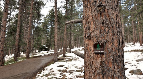
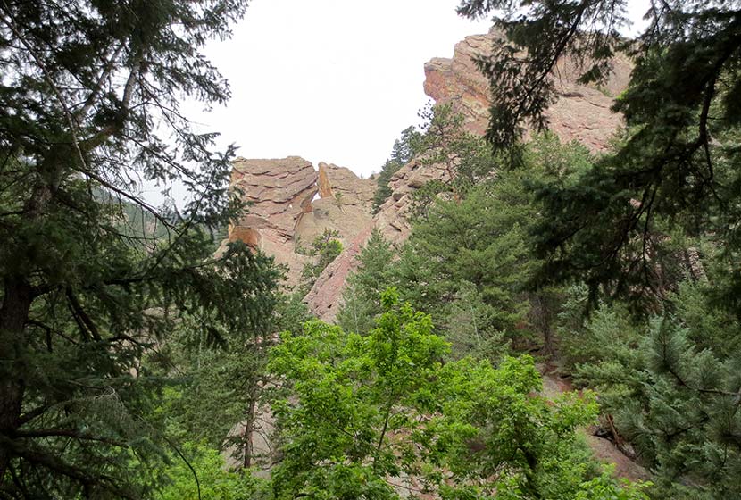
Enchanted Mesa Trail Near Boulder, Colorado
Boulder's Chautauqua park boasts some of the best hiking in Colorado, especially if you are looking for accessibility--many of the trailheads are right in town. The Enchanted Mesa trail lives up to its name. The dense pine forest and the wide curving path looks like something out of a fairy tale. It's a fairly easy hike, with a surprising amount of shade, great views of the Flatirons, and close to Denver. Before you launch out to explore Enchanted Mesa, be sure to check out our detailed description of the hike, the Chautauqua Park trail map, and our hiking tips for this great Boulder Hike.
Trail Snapshot: Enchanted Mesa Trail - Chautauqua Park
| Hike Distance | 1.8-2 miles |
|---|---|
| Difficulty | Easy |
| Duration | Approx 1.5 hr |
| Trail Type | Loop |
| Elevation Gain | +437′ |
| Seasons | All Year |
| Dogs | Allowed on Leash |
| Hike Trail Map | Click for a Trail Map |
| Denver Drive Time | 40 min |
| Directions | Click for Google Map |
| Town Nearest Hike | Boulder, Colorado |
| Beauty | Ponderosa pine forest, views of Boulder’s famous Flatirons |
| Activities | Hiking, Running, Picnics |
Start your hike at parking lot near the Chautauqua Auditorium Trailhead. There is limited parking at the trailhead picnic shelter, but you can find more space around the auditorium and in side streets. Keep in mind that parking in the Chautauqua park area fills up fast.
There are a few options you can consider before starting the hike.
1# Enchanted Mesa - McClintock Loop - 1.4 mile loop
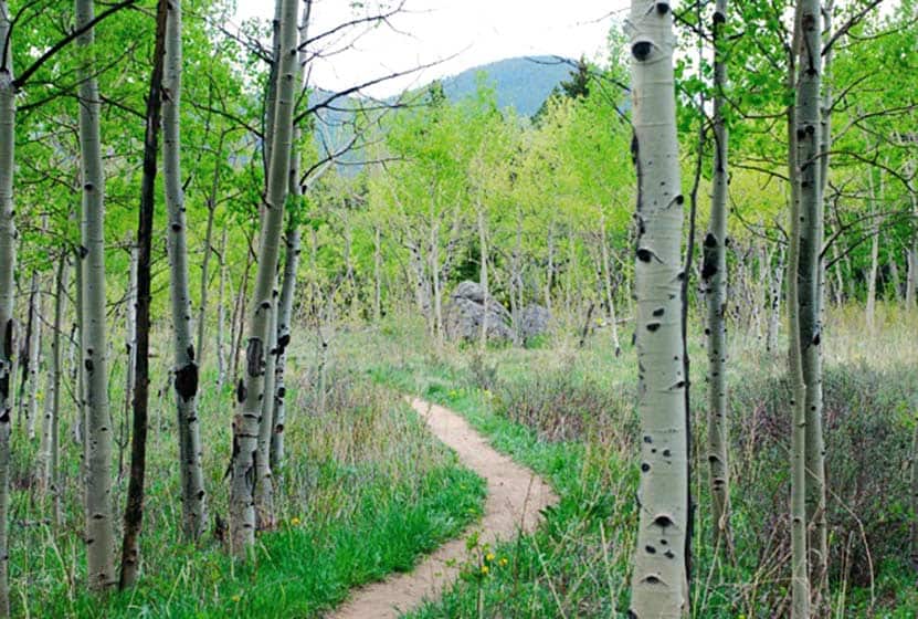
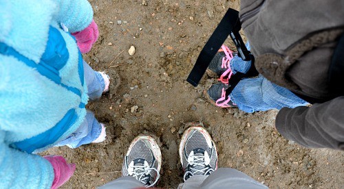
Your first possibility is to hike the trail clockwise by taking the Enchanted Mesa trail out, then returning on the McClintock trail, making it into a loop. You'll head out on the wide path of the Enchanted Mesa Trail which leads you gradually uphill, across a stone bridge, and onto the Mesa. Once you get on the Mesa, walk into a pine forest. The trees get thicker and taller as you go until you feel like you have walked into an enchanted forest. My kids, who are six and 3, hiked this early one Saturday in April (you'll see our muddy shoes at the end of the post), when snow still covered parts of the trail and the city was still asleep. It did feel like stepping, just for a moment, into another world.
When you get to where the Enchanted Mesa Trail intersects with the McClintock trail, turn right and take the the McClintock Trail. Because it's so narrow, this part of the trail doesn’t allow dogs. The return trail at least one steep section, but you'll find stairs cut into the hillside to help you on your way. The Mclintock trail was very muddy coming down, so we expect this trail to be muddy in the warmer days of winter, a lot of spring, and after the Summer rains. We've got a great tip below to help you with that.
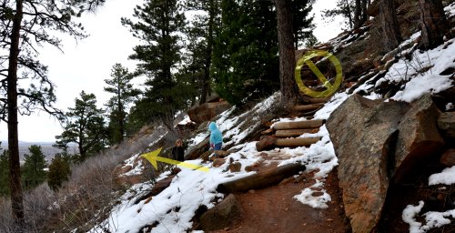
About halfway back along the McClintock trail, you’ll encounter an intersection where a rough set of steps lead up to the right, and on your left, you’ll see the path leading back down toward the creek valley. Go left/down (see the photo) to stay on the McClintock trail. On the way down, you will see the flood damage in the ravine caused by the 2013 flood.
2# - McClintock to Enchanted Mesa - Loop - 1.4 mile loop
This is simply hiking the same loop, but counter-clockwise. The benefit to this is that you get better views of the Flatirons hiking West on the McClintock trail. The McClintock Trailhead starts right from the picnic pavilion behind the Chautauqua Amphitheater. It is 0.7 miles long and ascends 335 feet to where it ties in with Enchanted Mesa.
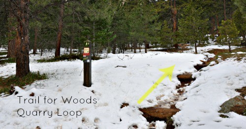
#3 - Enchanted Mesa + Quarry Loop - 1.8 miles
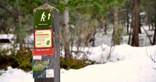
Quarry Loop is beautiful little jaunt off of the top of the Enchanted Mesa trail. If you wish to add 0.4 mile to your hike and enjoy the more of the mesa forest, follow either of the directions above, and look for the Quarry loop near the intersection of the two main trails. This turns your hike into a figure-eight. You will head uphill until you see an old stone cabin. When you get to the cabin, turn right and enter the short and steep stair-step climb to the quarry. When you get on the top you can relax in the hand-crafted chairs and take in the scenery of Chautauqua park.
If you add the Kohler Mesa trail to option #3 you can make your hike close to 2 miles long, giving you the chance to explore even more of the mesa.
This is a great hike any time of year, but is especially great in the Spring. We always find the people of Boulder very friendly, so expect good company. People will be out with their dogs, trail running, and talking with friends. Particularly in the early hours of the morning, it's idyllic.
Tips & Hiking the Enchanted Mesa Trail:
- It Can Be Muddy: Bring an extra pair of shoes or sandals, so that you’re not getting mud all over the floor of your car. There are bags at the trailhead for disposal of dog poop. Our kids shoes were covered with mud, and we used the bags to keep from getting mud all over the back of the car. An even better solution would be to bring plastic shopping bags with you.
- Dog Restriction: Dogs are not allowed on the Lower & Upper McClintock Trail. So, you'll have to return on the Enchanted Mesa trail with Fido, or check the map for other options.
- No Bikes: Bicycles are prohibited on the trails in the Chautauqua area.
- Bring a picnic or a snack: There are some great picnic spots along the Enchanted Mesa hike.
- Trail Map for Chautauqua Park: Trail Map Link
- Colorado Road Conditions: Colorado Road Conditions
- After the Hike: Lollicup Boulder Coffe&Tea
Weather
Map & Driving Directions
Click for Driving Directions
Royal Arch Trail
The hike up to Royal Arch in Boulder's Chautauqua Park is a serious workout, but the beauty of Bluebell canyon and the view of Royal Arch make it worth the journey. Our most important tip for making this an enjoyable hike is to go when it's not so crowded, during the early morning or on weekdays. Scroll down to get all the details you need for this hike in Boulder, Colorado: trail map link, driving directions, weather forecast, and more tips.
Trail Snapshot: Royal Arch Trail in Chautauqua Park
| Hike Distance | 3.5 miles Round Trip |
|---|---|
| Difficulty | Moderate to Difficult |
| Duration | 2-3hrs |
| Trail Type | Out and Back |
| Elevation Gain | Approx +1400′ |
| Seasons | All Year |
| Dogs | Allowed on Leash |
| Hike Trail Map | Click for a Trail Map of Royal Arch Area |
| Denver Drive Time | 40 min |
| Directions | Click for Google Map |
| Town Nearest Hike | Boulder, Colorado |
| Beauty | Rock formations, Bluebell Canyon, raptors, natural spring |
| Activities | Hiking, rock climbing |
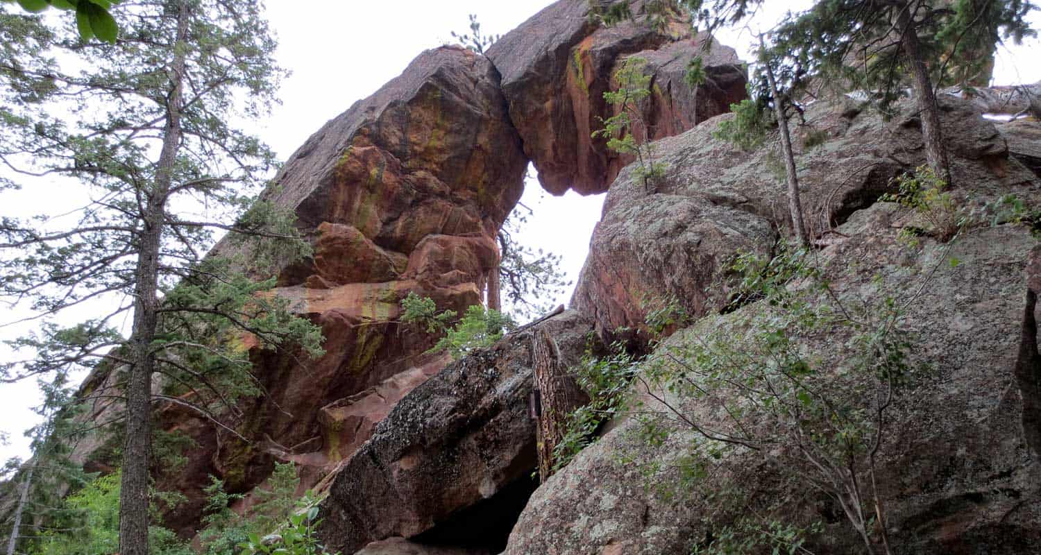
If you talk with someone who has hiked the trail up to Boulder's Royal Arch, they will tell you two things: 1) The Royal Arch, though not as grand as some of the arches in Utah's backcountry, is really a beautiful sight, and 2) That the hike is a real challenge.
While the trail is relatively short - 3.5 miles round trip - the hike up through Bluebell Canyon to Royal Arch has a lot of uphill and downhill, making the elevation gain around 1400' over the course of the trip. Because the trail has a lot of rock steps and is heavily used, the latter half of the hike requires some negotiation. It's still a good trail, just don't expect a walk in the park.
The Hike to Royal Arch
Beginning at the Chautauqua Park Trailhead, take the Bluebell Road Trail through the meadows and up to the Bluebell Shelter (see trail map here). You'll come to a junction near the Bluebell Shelter, and will see signs pointing you to the Royal Arch Trail.
Soon, you'll enter Bluebell Canyon. The Royal Arch trail will descend before beginning its climb to the top. This section of the hike is especially alive and enchanting during the early morning hours. Bluebell Canyon is home to raptors and is seasonally protected when the birds are hatching. The trail is still accessible during those times, but signs are posted to keep the canyon drainage clear of hikers.
The higher you hike, the more stairs you'll encounter. It's nothing like hiking the Incline in Colorado Springs, but it's still a real workout. If you hike to the Royal Arch on the weekend, this is where you'll begin to experience the trail congestion. In fact, I'd have to say that this was the most overcrowded trail I've hiked in Colorado. A lot of hikers had stopped to rest, huffing and puffing trailside. Others gathered right in the middle of the trail. I overheard several people deliberating whether or not to keep going, and watched others turn around without making it to the top. So, our first and most important tip would be to hike to Royal Arch early in the morning by getting on the trail before 8AM, or hiking the Royal Arch trail on a weekday.
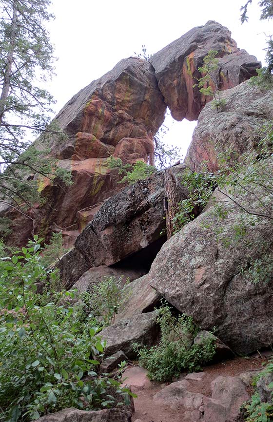
After pushing up to Royal Arch, be sure to walk around it and go through it. The views of Boulder are incredible. On a clear day, you can see all the way to Denver. I'd recommend taking a picnic or at least a snack, and kick back for a while. There is supposedly a way to make this hike more of a loop by taking a trail down the backside of the arch, but it's an unmarked trail and one hiker who took it warned against it. So, we recommend taking the marked Royal Arch trail back down to the shelter. From there, you have some trail options.
On my way back, I decided to take the Bluebell Mesa trail down to the Chautauqua trail, which led me home to the trailhead and ranger cottage. I'd highly recommend this route back. It takes you through a stand of pines on a mesa above the meadows of Chautauqua Park. You can pick up the Bluebell Mesa trail near the Bluebell Shelter soon after you exit the canyon.
Tips & Resources for Hiking to Royal Arch in Boulder:
- Leave Fido At Home: I love dogs; in fact, I took our Dog, Francine, on the hike up to Royal Arch. But it was so congested that it made it difficult for her and I to navigate the trail together. Other dog owners with long leashes nearly tripped several hikers along the trail. If you want to bring your dog on this hike, I'd recommend going early or going on a weekday.
- Bring Snacks and Water: It probably goes without saying, but be sure to bring food and water to refill your tank. This hike demands it.
- Bring Trekking Poles: The trail up to Royal Arch can be hard on the knees--especially the descent--so bring trekking poles if you have them. The trail is heavily shaded, so my guess is that it will ice up in the winter. Just another reason to bring something that will help you get traction.
- Take Time at the Top: Build time into your hike to rest and maybe have a picnic under the Royal Arch.
- Keep and Eye on the Weather: Talking to one of the rangers, he shared that storms can come up quickly along the Flatirons, which will catch hikers unawares. Because you are hiking through a densely wooded canyon and are so close to the mountain, it makes it difficult to really judge the skies. But the Flatirons area is like a lot of other mountain hikes, storms typically roll in during the early afternoon.
- Trail Map for Chautauqua Park: Trail Map Link
- Colorado Road Conditions: Colorado Road Conditions
- After the Hike: Ozo Coffee in Boulder, Colorado

Weather
Map & Driving Directions
Click for Driving Directions
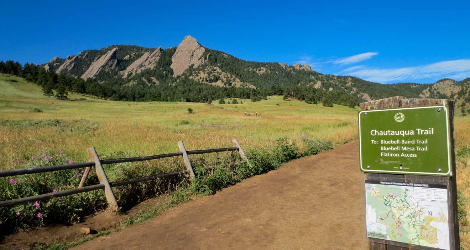
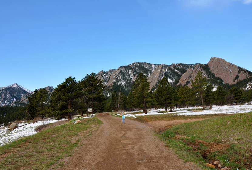
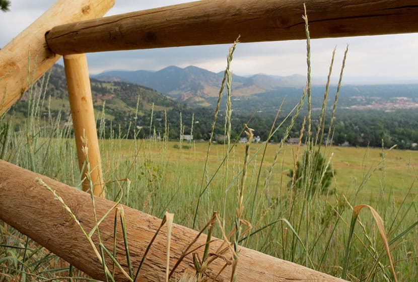
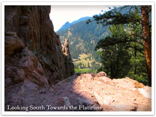
First and Second Flatirons Hike in Boulder
Hiking the Flatirons near Boulder, Colorado is a must. The trail draws you across an green meadow, then up through a notch between the First and Second Flatiron. You'll find the best part of this hike in the Flatirons at the end of the trail: some breathtaking and unmatched views of Colorado's Rocky Mountains. There's even more though. Explore the trail profile below to get links to the Flatirons map, hiking tips, trail details, and driving directions to the Chautauqua Park trailhead.
First and Second Flatiron Hike Trail Snapshot
| Hike Distance | 2.6 miles Round Trip |
|---|---|
| Difficulty | Moderate |
| Duration | Approx 2 hrs |
| Trail Type | Out and Back |
| Elevation Gain | +1400′ |
| Seasons | All Year |
| Dogs | Allowed on Leash |
| Hike Trail Map | Click for Map for Boulder Colorado's Flatirons Hike |
| Denver Drive Time | 45 min |
| Directions | Click for Google Map |
| Town Nearest Hike | Boulder, Colorado |
| Beauty | Views of Continental Divide, Expansive Meadows, Wildflowers, Flatirons Rock Formations, Cliffs |
| Activities | Hiking, Rock Climbing, Picnic Areas |
| Video | Click For Video |
The Flatirons are the most prominent feature of Boulder Colorado's landscape. They are beautiful to take in from a distance, but they are even better to explore. Here I'll give you a some options on how to make the most of the First and Second Flatiron trail, and some details on what to expect.
The Flatirons Trailheads at Chautauqua
#1 - Chautauqua Trailhead: You can start your hike from a couple different places. I chose Boulder's Chautauqua Park trailhead. The parking lot will fill up fast, by 8:30 on the weekend, but you can park along Baseline Road. The city of Boulder is doing some improvements on the parking area beginning September 3rd, 2013 and it looks like the lot will be closed. Here's a link for construction updates. But don't let that deter you, just park out on Baseline. The Chautauqua trailhead features an historic Ranger Cottage (link for hours of operation), and you'll find free trail maps for the flatirons in a box attached to the sign at the entrance to meadow.
#2 - Enchanted Mesa Trailhead: This is a lesser known trailhead (but probably well known by locals). Here's a google map to help you find it. From here, you can walk across to Chautauqua Park and pick up the Chatauqua Trail, or you can make a longer trip out of it by following the McClintock Upper Trail in. See the Chautauqua Area Hiking Map for details.
Get our Dayhikes Near Denver Hiking Guide. It includes our favorite hikes near Denver, packing lists, hiking food and snack ideas, and tips for hiking the Front Range of Colorado.
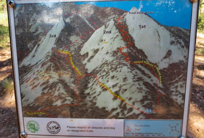
The Flatirons Panorama:
In the panorama video above, you'll see that the first flatiron is the most prominent. It's on the far right (North) and the second and third flatirons follow it to the south. There is an impressive canyon between the second and third flatirons that you'll get to peer down into towards the end of the trail. But let's start this hike profile at the trailhead.
The First Flatirons Trail Sequence
Here's the basic set of trails I'd recommend just because it's the most direct approach: Chautauqua Trail to First and Second Flatiron Trail. On the way back, I'd recommend the Bluebird Mesa trail; it takes you through a pine glade along the spine of a Bluebird Mesa, then gently drops back down to the Chautauqua trail near the trailhead. This makes for a roughly 2.5 mile hike.
Make it a loop. Deb Stanley details an interesting loop by taking a little known trail down the back side of the flatirons that hooks back into the Saddle Rock Trail. Looks like fun, but it also looks like it could be easy to get turned around in there if you're not careful. Check out the details on her loop trail profile if you're interested in taking this route.
First and Second Flatirons Hike Details
This photo gives you the best overview of the Flatirons one and two trail. Basically, once you break out of the meadow and start on the 1st and 2nd Flatirons trail, your going to ride the ridge of the 2nd flatiron up to a notch between the 1st and 2nd Flatirons. The trail continues behind the flatirons, then bends north and takes you up into a canopy formed by the back of the first flatiron.
 Starting at the Chautauqua Trail, you'll hike through the spectacular meadows at the base of the flatirons. If it's after a rain, be prepared for a lot of rain along what is essentially a fire road. The sides of the trail here have a good bit of poison ivy that tries to reach out and touch your calves, so keep an eye out for it. What I found most interesting about this section of the trail was the diversity of both plants and trees along the trail. There is a greater variety of deciduous trees and shrubs that I've seen anywhere on the front range.
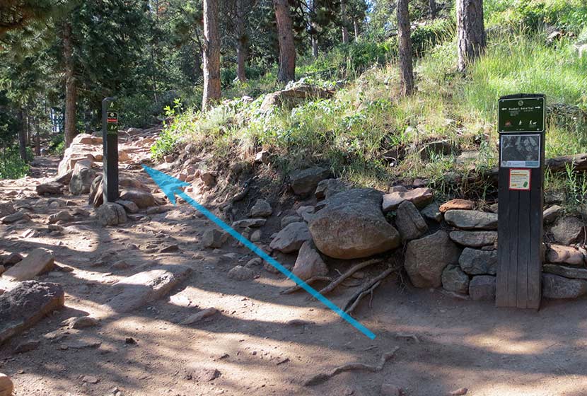
After taking the Bluebird-Baird Trail (left), you'll encounter a fork in the trail. Follow the signage towards the 1st and 2nd Flatirons trail (see photo below). Soon the trail will fork again and you'll want to take the 1st and 2nd Flatirons trail. The signage is really good in the Chautauqua/Flatirons area.
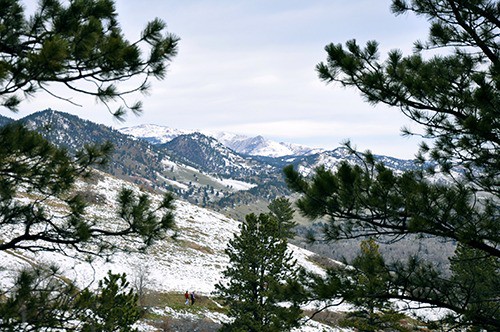
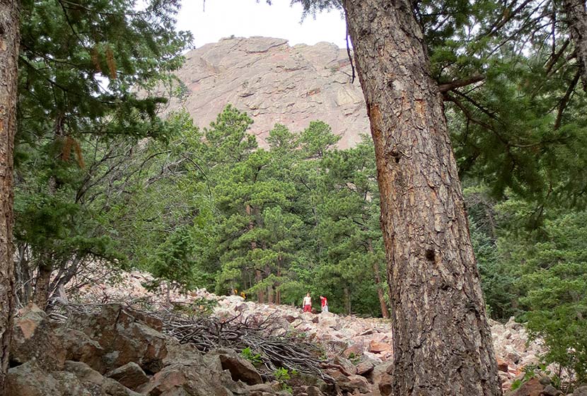
Emerging from the woods, you'll hike up through a long talus field, but the trail is well-constructed through this gigantic pile of rock. Be sure to look back at the views that open to Boulder.
 The trail goes in and out of the shade, over a lot of rock, and eventually to a short scramble over some larger rock to regain the trail. The next landmark you'll reach is the notch between the first and second flatiron; you'll see the angled outcrop of the second flatiron just below the notch (photo below). This is a great place to stop and relax.
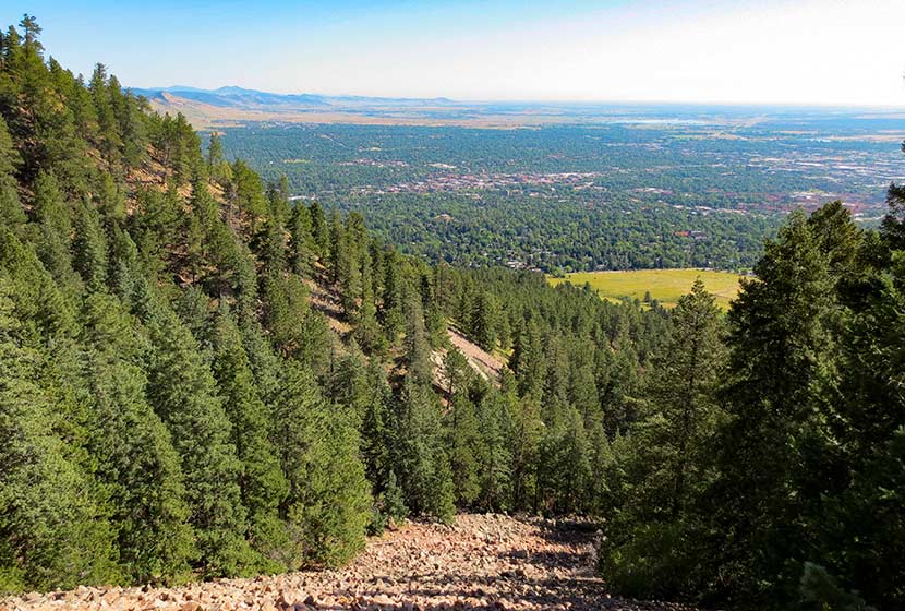
 The notch between the first and second flatiron offers more views of Boulder and a birds-eye view of the CU campus, it's terracotta roofs against the green of the city lawns.
But the better place to take a break is just behind the notch. Here, you'll be able to look down into canyon that runs between flatiron two and three, and you get a great view of the imposing profile of flatiron three.
 Then take the trail up a few switchbacks as it bends north. You'll hit a saddle but the trail will continue to bend to the right, until you find yourself in the shade of the massive top of the first flatiron. Back here you'll find all kinds of rock shelves and nooks to sit and take in some of fantastic views of Colorado's Rocky Mountains to the West.
 Tips & Resources for Hiking the First and Second Flatirons:
- TIP: This hike gets really crowded, so start early (before 8:30 AM).
- TIP: Take a lunch or breakfast and coffee with you. The first flatiron nooks are perfect for just sitting and enjoying a picnic.
- TIP: Weather can come up fast on the flatirons in the summer. Just be aware that it can change fast and bring a rain jacket.
- TIP: Dogs are allowed if they are leashed. Boulder does have a special tag you can get for your dog to allow it off leash in the park. It's called the Voice and Sight Control tag and you can get more information here.
- After the Hike: Ozo Coffee Roasters in Boulder
- Trail Map for Chautauqua Park: Trail Map Link
- Colorado Road Conditions: Colorado Road Conditions
Weather
Driving Directions to First Flatiron Trailhead
Click for Driving Directions
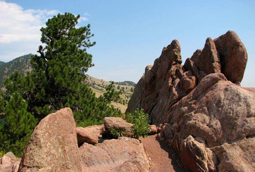
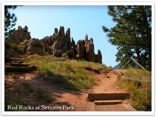
Red Rocks Trail at Settlers Park in Boulder
A giant underground sandstone formation runs from Ft. Collins all the way through Garden of the Gods in Colorado Springs. Here at Red Rocks Trail in Boulder, the rock juts out of the ground to transform the landscape. It makes for an inspiring short hike. Explore the hike snapshot and detailed trail profile below to get a feel for this great hike near Boulder.
Trail Snapshot: Red Rocks Trail at Settlers Park
| Hike Distance | 1 mile Loop + 0.4 mile spur |
|---|---|
| Difficulty | Easy |
| Duration | 45 min |
| Trail Type | Loop with Spur |
| Elevation Gain | +300′ |
| Seasons | All Year |
| Dogs | Allowed on Leash |
| Hike Trail Map | Click for a Map of Red Rocks & Anemone Trail |
| Denver Drive Time | 45 min |
| Directions | Click for Google Map |
| Town Nearest Hike | Boulder, Colorado |
| Beauty | Red Rock Formations |
| Activities | Picnic area, no bikes, hiking trails, rock climbing |
The trails of Red Rocks at Settlers Park in Boulder interconnect to form more of a labyrinth than a straightforward hike. But there is a way around all that---literally. Pull up the Boulder Open Space & Parks Map and follow the outer perimeter trail to form an approximately 1 mile loop around the sandstone red rock formations that jut out of the ground in the center of the park.
You can add an additional .8 mile to your hike by taking the Anemone trail to the west, rising another 400ft where it tops out on a hill to give you views of the City of Boulder, the Red Rocks Park, and the Colorado Front Range. Even with the Anemone trail spur, it's a short hike, so you might want to add one of the Mt. Sanitas hiking trail options to your adventure. The Mt. Sanitas trail is just North of the Centennial Trailhead.
Tips & Resources for Hiking the Red Rocks Trail at Settlers Park :
- This trail is not to be confused with Red Rocks in Denver. If you are interested in hiking at Red Rocks in Denver, you can access a trail profile for the Trading Post Trail here.
- Getting There: You can access Boulder's Red Rocks Trails from either the Centennial Trailhead or Settlers Park Trailhead parking areas.
- For information on rock climbing the rock formations in Settlers Park see the Mountain Project's page.
- Trail Map for Settlers Park Boulder: Trail Map Link
- Colorado Road Conditions: Colorado Road Conditions
- After the Hike: Ozo Coffee
Weather
Map & Driving Directions
Click for Driving Directions
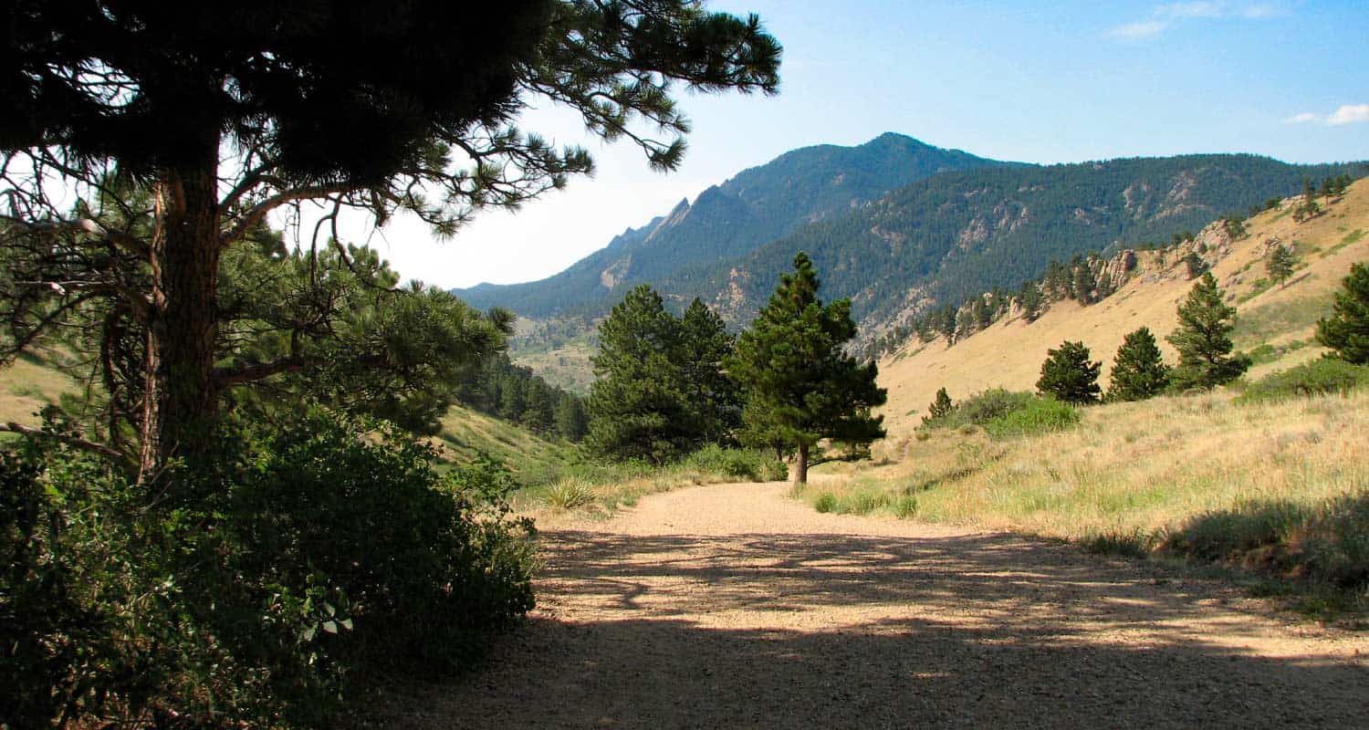
Mt. Sanitas Hike Near Boulder
If you are visiting Boulder, this is a great Colorado hike. Mt. Sanitas gives you several trail options ranging from an easy stroll along a meandering brook to a demanding trail up the mountainside. Explore the trail profile below for all the info you need on this hike near Boulder.
Trail Snapshot: Mt. Sanitas Hike in Boulder
| Hike Distance | 3.1 miles or 2 miles |
|---|---|
| Difficulty | Medium+ with Easier Options |
| Duration | Approx 2 hr |
| Trail Type | Loop |
| Elevation Gain | Approx +1343′ |
| Seasons | Year Round |
| Dogs | Allowed on Leash |
| Hike Trail Map | Click for a Trail Map |
| Denver Drive Time | 45 min |
| Directions | Click for Google Map |
| Town Nearest Hike | Boulder, Colorado |
| Beauty | Front Range mountain views, views of Boulder, wildlife: mule deer, raptors, foxes, and coyotes |
| Activities | Picnic area, horseback riding, hiking trails, climbing, No Bikes Allowed |
Mt. Sanitas offers three different hike options, ranging from the more difficult climb up the mountain, to an easy walk through a peaceful valley. Sanitas is Latin for "health", and this hike may either get you in better shape (the 3.1 mile loop), or restore your sanity (the easier options). If you are visiting Boulder, this is a great Colorado hike.
3 Hike Options at Mt. Sanitas in Boulder, Colorado
1 - The Mt. Sanitas Loop - 3.1 Mile Loop - Medium+
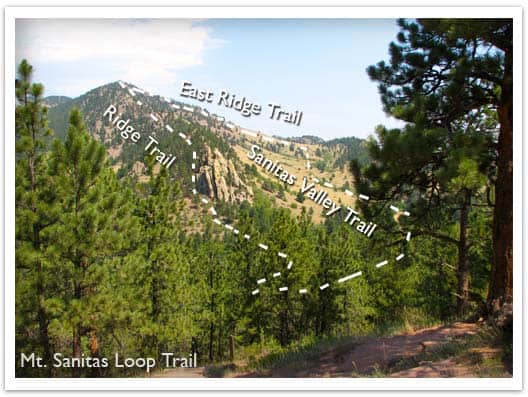
This is the classic hike at Boulder's Mt. Sanitas, and it's the most difficult of the three hike options because it involves a series of log and rock steps that will leave your quads and knees either thanking your for the workout or aching for a couple days afterwards. Because of this, we would give it a Medium+ difficulty rating. The prize of this Front Range Hike are the views at the top. You'll be able to look down into Boulder and get some great views of Colorado's Front Range.
2 - Mt. Sanitas Valley Hike - 2 Mile Out-and-Back - Easy
Here's the easiest option; 1 mile straight up the valley and back. The two words that best describe the Sanitas Valley trail: idyllic and busy. Dogs run about and jump in the creek that runs along the beginning of the path, runners fly by, and families talk and stroll together. The trail rises gently at first, then goes into more of an incline. We took our stroller; it worked fine, but was tough pushing the kids up the last 1/4 mile uphill. We turned around just after the Dakota Ridge Trail junction, making it a 2 mile out-and-back hike.
3 - Dakota Ridge Trail at Mt. Sanitas - 2 Mile Loop - Easy to Medium
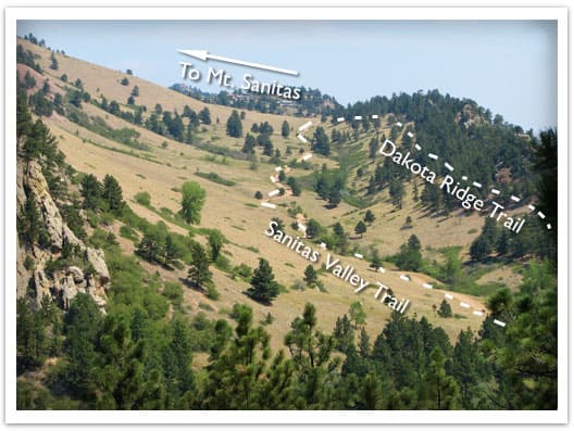
You'll find side trails running East/West off of the Sanitas Valley trail which will take you up onto the Dakota ridge, a hogback that boxes in the Sanitas Valley. You can make this an out-and-back hike, or turn it into a loop by hiking back through the valley (see photo above and the Mt. Sanitas Trail Map for the route).
Tips & Resources for Hiking Mt. Sanitas in Boulder:
- Parking: This is kind of a no-brainer, but get to the trailhead early. I think we arrived around 8am on a Saturday and grabbed the last parking spot. However, we noticed that many people were walking to the trailhead from town, so there are other parking options.
- No Shade: Bring your sunscreen; the trail is mostly exposed.
- Lots of People: If you are looking for solitude, I'd recommend trying another hike. The Mt. Sanitas trail is essentially in Boulder, and its great location means that it's quite busy.
- Trail Map for Mt. Sanitas Trail: Trail Map Link
- Colorado Road Conditions: Colorado Road Conditions
- After the Hike: Ozo Coffee
Weather
Map & Driving Directions
Click for Driving Directions
Forsythe Canyon to Waterfall and Gross Reservoir
Looking for a trail that will provide some shade on a hot Colorado day? This hiking trail has shade, plus a waterfall, a stream, a canyon, and lake. It's hard to beat. Forsythe Canyon is just outside Boulder, Colorado (1hr 15min from Denver), and is an easy to moderate hike. Check out our full hiking trail profile for details and be sure to read the directions to this trailhead carefully.
Trail Snapshot: Forsythe Canyon Trail
| Hike Distance | 2 miles+ Round Trip |
|---|---|
| Difficulty | Easy |
| Duration | 2 hr+ |
| Trail Type | Out and Back |
| Seasons | Late Spring to Fall |
| Dogs | Allowed on Leash |
| Denver Drive Time | 1 hr 15 min |
| Directions | Click for Google Map (note: people miss trailhead often, see profile and comments below for details) |
| Town Nearest Hike | Boulder, Colorado |
| Beauty | Waterfall, Wildflowers, Reservoir, Woodland Canyon |
| Activities | Hiking Trails |
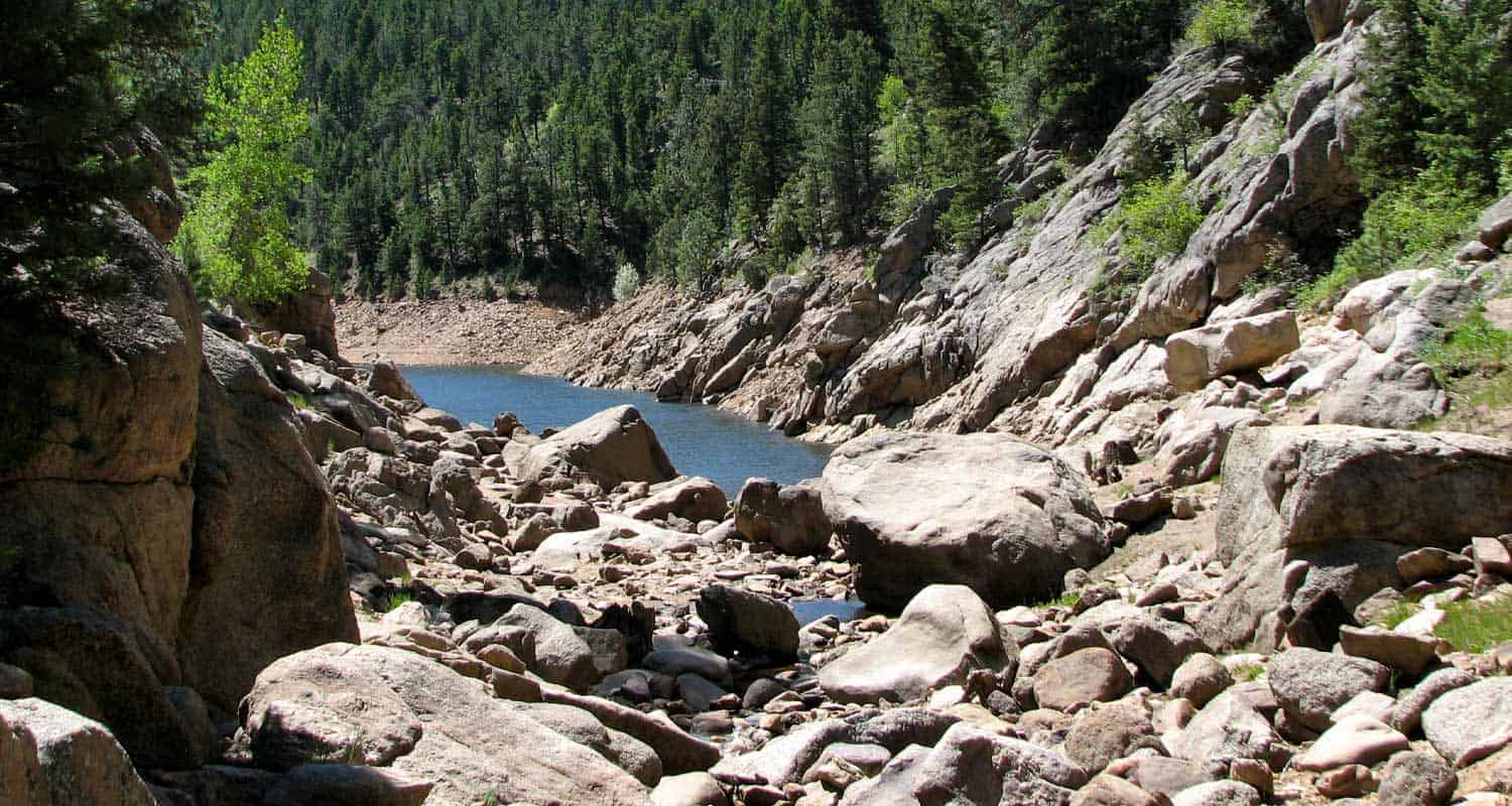
The shade of a wooded canyon, combined with a waterfall, ending at a blue lake, make this hike near Boulder Colorado worthwhile. Though it's probably 25' high, the waterfall is not what I'd call spectacular. So, if you are going for this waterfall, I'd recommend going early in the season when the snowmelt is at its peak in May and early June.

The trail winds gently downhill through a canyon, beside a creek, sheltered beneath fir and spruce. In fact, of the hikes we have profiled, this trail may provide more shade than any trail near Denver. You'll come upon the falls about 1 mile into the hike and the reservoir is just 200 yards further down the trail. In fact, reaching the clear blue water was the highlight for our kids.
We skipped rocks and hiked along the sandy and rock rim so that we could explore more of the lake. With the water levels being so low, and a large tree blocking the shot, I couldn't get a good photo of the falls.

One important note. The trail is a bit difficult to find just above the waterfall, in fact, if you take the wrong route, it appears to lead you down a rock face - which is not a good idea, especially with kids. The correct route bears to the left of a cedar tree, will lead you up further above and away from the falls, then back down into the canyon floor. I've posted a photo below showing the juncture. Even in the photo, it's hard to see the trail.

Tips & Resources for Hiking Forsythe Canyon:
- TIP: If you are coming from Denver, it's quite a drive. The payoff is that the parking lot was almost empty on memorial day weekend. We recommend making a day of it and spending some time in Boulder before or after the hike.
- TIP: The Reservoir is stocked with Kokanee Salmon, and this stretch of it is where they supposedly like to hang out. So, bring your fishing gear. Here is a link to a Dept. of Wildlife PDF with information on the stock on the lake and some links to the fishing regulations for Gross Reservoir.
- TIP: Swimming and Wading are Prohibited
- TIP: The Google Map & Directions: The trailhead parking lot is new, and really nice (with a restroom), and the directions above are accurate. However, I get a lot of email from folks who plug this map into their GPS and somehow miss it and try to drive down FR359. Remember, GPS is only accurate up to a point. Once you turn off of Magnolia and onto 68, drive for 2 miles then turn right into the parking lot just before FR359. Look for a gravel parking lot with a restroom and a wooden fence surrounding the perimeter. You can zoom in on the Google Map to get a feel for what it looks like. Google updated the satellite photos recently, so the parking lot now shows. You can check here for seasonal road closures of FR359. Or you can all 303-541-2500 (Boulder Ranger District) to check the road status before heading out on your adventure
- TIP: Be sure to take the recommended route using Magnolia road. We've had a few emails from folks trying to reach the Forsythe Canyon Trailhead from Lakeshore Road. My understanding is that it's not possible, or at least highly problematic.
- After the Hike: After the Hike: Ozo Coffee
- Colorado Road Conditions: Colorado Road Conditions

Weather
Map & Driving Directions to Forsythe Canyon Trailhead
Click for Driving Directions
Rattlesnake Gulch Trail at Eldorado State Park
The Rattlesnake Gulch trail takes you up the sides of Eldorado Canyon, one of Colorado's historic State Parks. This lollipop trail takes you past the ruins of the Crags Hotel, then on to gain views of the Continental Divide. Scroll down to look over the trail snapshot, then explore the trail details and tips below for this rewarding hike in Eldorado Canyon State Park.
Trail Snapshot: Rattlesnake Gulch Trail at Eldorado Canyon
| Hike Distance | Approx 2.5 to 4 miles |
|---|---|
| Difficulty | Moderate |
| Duration | 1.5-2.5 hrs |
| Trail Type | Lollipop w/Spur Option |
| Seasons | Spring, Summer, Fall |
| Dogs | Allowed on Leash |
| Hike Trail Map | Click for a Trail Map |
| Denver Drive Time | 45 min |
| Directions | Click for Google Map |
| Town Nearest Hike | Boulder, Colorado |
| Beauty | Canyon, waterfalls and cascades, cliff swallows, cliff-top views, geologic features |
| Activities | Picnic areas, horseback riding, mountain biking, rock climbing |
| Fee | Link to Fees Page |
If your legs are ready to gain some quick elevation to some rewarding views, the Rattlesnake Gulch trail will give you just that. This trail starts at the west trailhead of the Fowler Trail about 1/2 a mile into Eldorado Canyon. The hike first takes you about 1.2 miles to the site of the Crags Hotel. The hotel was built in 1908 and visitors could reach it by taking an incline railroad and by an old wagon trail. In 1912, the hotel burnt to the ground, and just a few ruins remain. The parks department has put up interpretive signs to give you an idea of what the site was like in the early 1900's.
If you continue past the Crags Hotel site, you can add on an additional 1.4 miles by hiking the Rattlesnake Gulch Loop. A spur along the trail takes you to the Continental Divide overlook, where you can look out to the plains and towards a few peaks to the west. If you don't want to hike the entire loop, but you want to catch the view from the overlook, take the trail to the right after the hotel site and hike about 10 more minutes. See the map link above for the exact location of the spur that leads to the overlook.
The picture above is looking northeast towards the Cadillac Rock area. If you take a pair of binoculars, scan the formation for rock-climbers. Eldorado Canyon makes for some great Denver area hiking. It's one of those places with so many unique features, that you'll find yourself drawn back there time and time again.
Tips & Resources for Hiking the Rattlesnake Gulch Trail at Eldorado State Park:
- Exact Trail Length: Exact trail lengths are approximate until we can GPS this one. We've noticed discrepancies on maps and reports. So, be sure to add some buffer time on to this hike.
- Parking: Parking fills up fast at Eldorado Canyon. So, we suggest you go early in the day, or as the crowds are filtering out of the park in the late afternoon. As well, you'll find weekdays less crowed. Eldorado Canyon is open from sunrise to sunset year round.
- Directions: Use the driving directions on this page. They will lead you to the nearest parking area to the Rattlesnake Gulch Trailhead.
- Fee: There is an $8 parking fee per car or you can use your Colorado State Parks Annual Pass
- Trail Map for Eldorado Canyon State Park: Trail Map Link
- Colorado Road Conditions: Colorado Road Conditions
- After the Hike: Boxcar Coffee Roasters in Boulder
Weather
Map & Driving Directions
Click for Driving Directions