Finch Lake is a 4.5 mile hike through pines, aspen glades, and wildflower laden meadows to a sub-alpine lake where the forest surrounds its shores. The Finch Lake trail is a great choice for those who prefer solitude as it’s one of the lesser traveled trails in the Wild Basin region of RMNP. Explore the full Finch Lake hike profile below for trail map, driving directions, and more tips and details to help you enjoy this adventure in Rocky Mountain National Park.
Note: Rocky Mountain National Park now requires timed entry permits from May 27th through October 10th. See the RMNP permits page for more information.
Trail Snapshot: Finch Lake in Rocky Mountain National Park
| Hike Distance | 9 miles Round Trip |
|---|---|
| Difficulty | Moderate |
| Duration | Approx 5-6 hr Round Trip |
| Trail Type | Out and Back |
| Starting Elevation | 8470′ |
| Elevation Gain | Approx. +1442′ |
| Seasons | Spring through Fall |
| Dogs | Prohibited in RMNP |
| Hike Trail Map | Click for a Map of Finch Lake RMNP |
| Denver Drive Time | 1 hr 30 min |
| Driving Directions to Finch Lake Trailhead | Click for Google Map |
| Town Nearest Hike | Allenspark, Colorado |
| Beauty | Waterfall, mountain views, meadows, aspen, river, wildlife: blue dragonfly, jackrabbit, mallard, Abert’s squirrel, elk, deer, moose, bear; wildflowers |
| Activities | Picnicking, hiking trails, snowshoeing, horseback riding, backcountry camping (with a permit), photography |
| Fee | Park Pass Required |
Parking & Trailhead Information for Finch Lake
The Finch Lake Trailhead is located approximately 1/5th of a mile east of the larger Wild Basin Trailhead near Allenspark, Colorado. Because there is very limited parking at the Finch Lake Trailhead, most hikers will need to park at the Wild Basin Trailhead and add the 1000′ feet of trail between the Wild Basin Trailhead and the Finch Lake Trailhead to their journey. There is an alternative approach via the Allenspark Trailhead. However, the route described in this trail profile will be from the Finch Lake Trailhead nearest to the Wild Basin Trailhead.
- Map and Driving Directions to the Finch Lake Trailhead
- Map and Driving Directions to the Wild Basin Trailhead
The Hike: Finch Lake Trail in RMNP
The hike up to the Lake is a steady climb through a forest of pine, aspen, spruce, and meadows laden with wildflowers. It begins with a set of switchbacks then follows the contours of a moraine. After gaining the ridge of the moraine, the trail begins a gentle descent through one of Rocky Mountain National Park’s most stunning displays of wildflowers. Near the bottom of the moraine, just above Fox Creek, the trail will come to its first junction. The the trail to the right/west leads towards both the lake (the left/east trail leads to the Allenspark Trailhead). Climbing higher, the trail will pass an overlook with views of the distant mountain peaks and the greater Wild Basin area.
The next trail junction–at approx. 2.5 miles–has been named “Confusion Junction” because of its power to confound hikers. Pause and study the trail signage in order to choose the correct trail. The correct way is the trail labeled “Pear Lake” and/or “Finch Lake.”
After approximately 1/4 mile, the trail works its way through a burn area from a 1978 fire, now in full recovery mode and blanketed with summer wildflowers. Continuing to work uphill, the trail makes several stream crossings before a descent to the lake, which begins at 3.8 miles. Then, at approximately 4.25 miles, the trail makes a hard right-turn. This part of the trail is often obscured by snow as late as as midsummer and early as the first signs of autumn.
At the Lake the trail wraps around the eastern edge, then the northern shore of the lake. During midsummer, swarms of bright blue dragonflies dance along its waters. The Finch Lake backcountry camping sites are located on the north and northwestern side. These backcountry camping sites can be reserved through the RMNP Backcountry Offices.
Finch Lake is not a good fishing destination. However, Pear Lake, just 2 miles further up the trail, is a much better destination for anglers and offers spectacular views of the rugged peaks surrounding it.
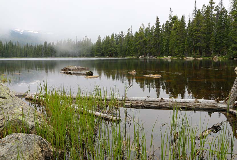
Finch Lake – Another View

Tips & Resources for Hiking to Finch Lake in RMNP
- Prepare: It’s a long and demanding hike, so bring lots of water and high-energy food.
- Packing List: Always pack the 10 Essentials. Download our Hiking Guide to get list and dayhiking packing checklist.
- Get there early: Parking lot might get full even early in the morning. Hikers should expect to have to park at the Wild Basin Trailhead and add approximately 1/2 mile to their round trip hike (1000′ one-way to the Finch Lake Trailhead).
- You’re in Bear Country: Black Bears live in the Wild Basin area and are active on the months of April through November. Be aware, dispose of your food responsibly, and don’t food or anything else with a strong scent in your vehicle.
- Trail Map for Wild Basin Area: Trail Map Link
- Colorado Road Conditions: Colorado Road Conditions
- Photo: We would like to express our gratitude to Shea Oliver for sharing such amazing photographs of this hike.
- After the Hike: Rock Creek Tavern & Pizzeria
Weather
Map & Driving Directions
Click for Driving Directions


