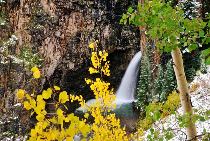
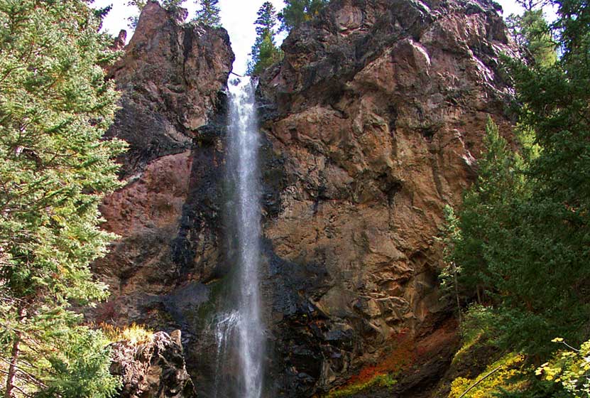
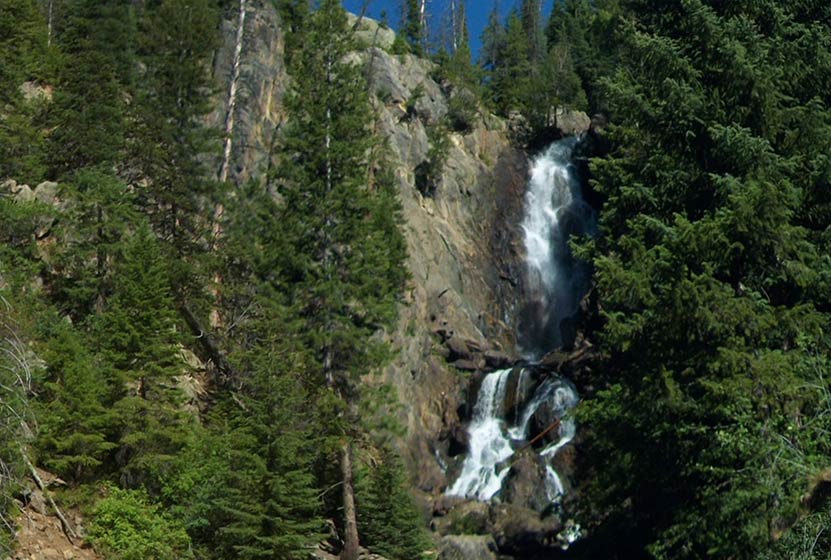
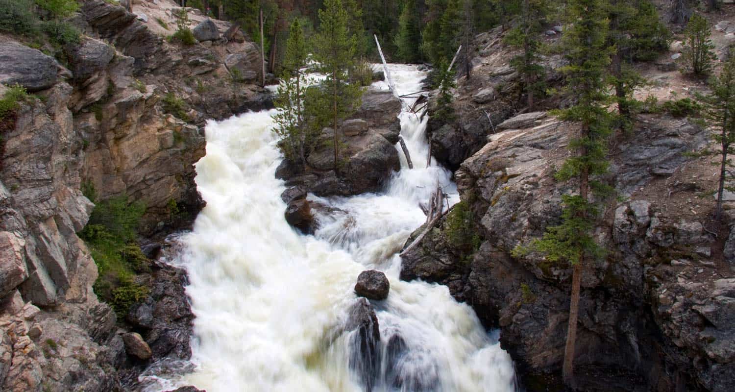
Whitmore Falls Near Lake City Colorado
Whitmore Falls is a lesser-known waterfall deep in the mountains of Colorado. But, it is just a 1/10th of a mile hike from the pull-off along Engineer Pass Road. It's a great destination hike for those vacationing in the Lake City area and are looking to combine a scenic drive with a short waterfall hike. Explore the full Whitmore Falls hike profile below for a trail map, driving directions, and all the details you need to enjoy this adventure near Lake City, Colorado.
Trail Snapshot: Whitmore Falls Near Lake City, Colorado
| Hike Distance | 0.2 mile Round Trip |
|---|---|
| Difficulty | Easy |
| Duration | Approx 15 min Round Trip |
| Trail Type | Out and Back |
| Starting Elevation | 9970′ |
| Elevation Gain | Approx -50′ |
| Seasons | May-September |
| Dogs | Allowed On Leash |
| Hike Trail Map | Click for a Map of Whitmore Falls |
| Denver Drive Time | 6 hr |
| Driving Directions to Whitmore Falls, Colorado | Click for Google Map |
| Town Nearest Hike | Lake City, Colorado |
| Beauty | Scenic Drive, Waterfall, Historic Capitol City Landmark |
| Activities | Short hike, Scenic Drive |
Directions, Parking, & Trailhead Information
Whitmore Falls is off the beaten path, located about 1hr west of Lake City, Colorado along the Alpine Loop Scenic Byway. From Lake City, take 1st Street northwest, then a left onto the Alpine Loop Scenic Byway/20/Engineer Pass Road. This dirt road which follows Henson Creek is closed December through May. It may be closed or difficult to navigate depending on weather and how recently its been graded. Typically, it is navigable for 2WD passenger cars up to Whitmore Falls, but SUVs will fare best on this stretch of road.
Beyond Whitmore Falls, the road requires higher clearance vehicles more suitable to the difficult terrain, and drivers who possess off-road driving experience. See the Colorado BLM site for more information on the Loop. Whitmore Falls is located approximately 11 miles West of Lake City, and about 2 miles after passing the Capitol City Landmark, a set of restored historic buildings. Take your time, the drive and the scenery is half the adventure.
The parking area for Whitmore Falls is a small pulloff on the right/west side of the road. The falls trail should be marked with a sign on the opposite side of the pulloff. Because of the limited cell service in this part of Colorado, we advise that drivers not rely on phone-based map services that require a cellular connection. Take care in crossing the road to the other side where you can make your way down to the waterfall.
The Hike to Whitmore Falls

Tips & Resources for Hiking to Whitmore Falls
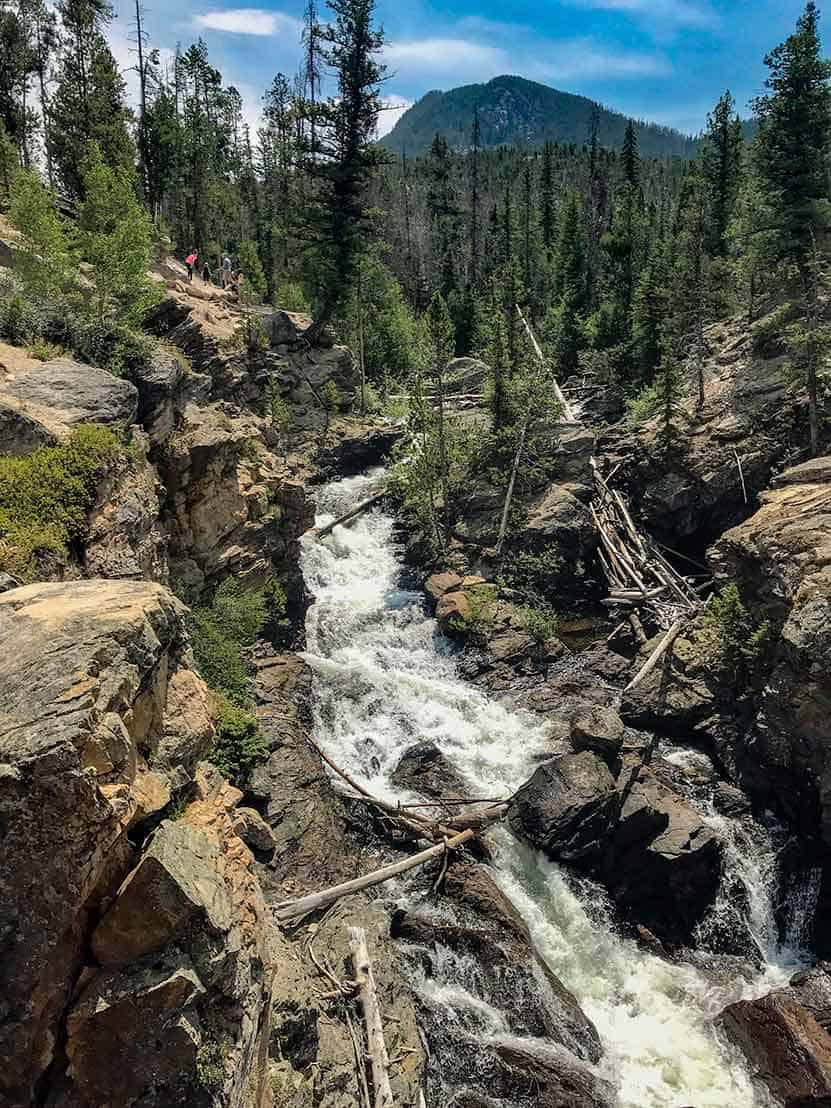
The drive to Whitmore Falls is more harrowing than the hike. It's just a short 1/10th of a mile from the roadside down to the falls. However, it is steep and the terrain is mostly gravel, much of it talus and loose scree. So, take care making your way down to the falls. Trekking poles will be a great aid in making it down the switchback trail to the overlook and to the falls. The trail can be located near the Whitmore Falls BLM sign.
Whitmore Falls is a plunge waterfall that launches over 40' from the rock cliffs surrounding Henson Creek. Depending on the flows of Henson Creek, the base of the waterfall provides close access for viewing the falls.
- TIP: Bring trekking poles to assist the short hike down the steep, gravel path.
- Take Your Time: Pack a picnic lunch, and enjoy the scenic drive. Hikers can stop and explore the Capitol City historic site before or after their visit to Whitmore Falls.
- Packing List: Always pack the 10 Essentials. Download our Hiking Guide to get list and dayhiking packing checklist.
- Colorado Road Conditions: Colorado Road Conditions
- Photo: We would like to express our gratitude to Dan Parker for sharing such an amazing photograph of this hike.
- After the Hike: Lake City Cafe
Weather
Map & Driving Directions
Click for Driving Directions See More Detailed Driving Directions Above
Zapata Falls Hike Colorado
The hike to Zapata Falls is a perfect family adventure. The 30 foot waterfall is back an easy .4 mile trail, and requires wading through Zapata creek to gain the best views under the shower of the falls. Because it's quite a drive from Denver, we recommend camping at the nearby campground and adding a visit to the Great Sand Dunes National Park to your adventure. Explore the full Zapata Falls hike profile below for driving directions, and all the details you need to enjoy this unusual Colorado waterfall.
| Hike Distance | 0.8 mile Round Trip |
|---|---|
| Difficulty | Easy |
| Duration | 30-45 min Round Trip |
| Trail Type | Out and Back |
| Starting Elevation | 9035′ |
| Elevation Gain | Approx +215′ |
| Seasons | Year Round |
| Dogs | Allowed On Leash |
| Hike Trail Map | Click for a Map of Zapata Falls Trail |
| Denver Drive Time | 4 hr |
| Driving Directions to Zapata Falls | Click for Google Map |
| Town Nearest Hike | Alamosa, Colorado |
| Beauty | Waterfalls, panoramic views of San Luis Valley, views to the Great Sand Dunes |
| Activities | Hiking, birding, photography, picnicking, camping |
Parking & Trailhead Information for Zapata Falls Trail
Like most of the best hikes in Colorado, the trailhead for Zapata Falls is out in the middle of nowhere--well, almost. It's about 8 miles south of Great Sand Dunes National Park and 29 miles from Alamosa, Colorado. Parking is limited, so arrive early in the morning to guarantee a space--or visit on a weekday. Memorial Day weekend is the busiest time of the year for Zapata because so many families visit the neighboring Great Sand Dunes and stay at the campground during that weekend. If the parking lot is full, the road leading into the trailhead lot offers roadside parking; just park with care. The trailhead has toilet facilities.
The Hike to Zapata Falls
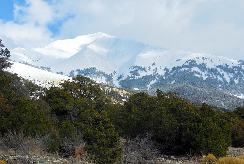
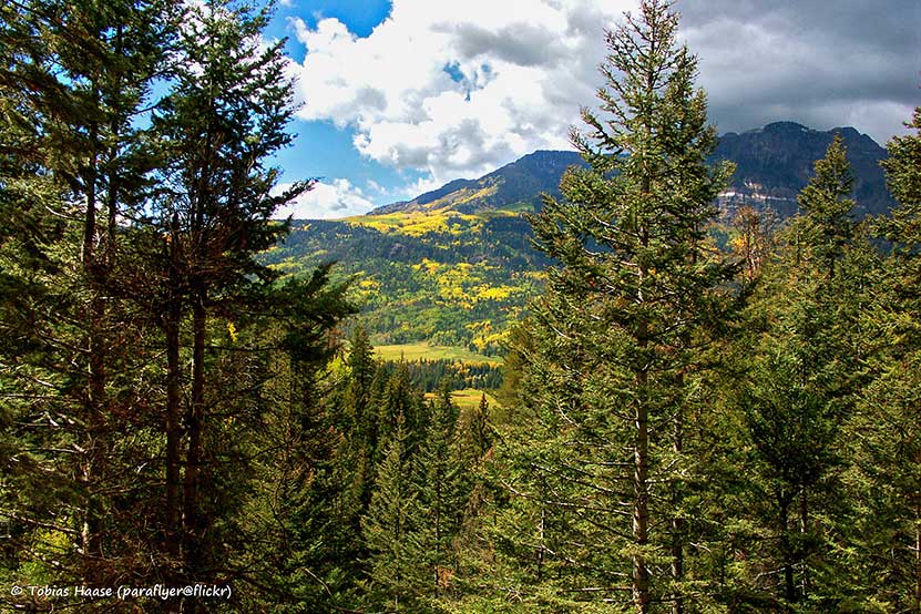
The hike to Zapata Falls is short and refreshing. The trail is well-constructed with benches along the way for hikers who need to take a breather. However, it's a very popular trail and you'll want to hit the trail early to avoid waiting in line to see the falls (and to avoid the midday heat). Along the way, you'll take in the scent of juniper trees and gain views of both the Great Sand Dunes National Park and the larger San Luis Valley of Colorado.
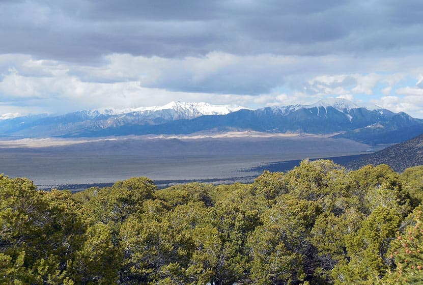
Views to the Great Sand Dunes courtesy of Patrick Mitchell
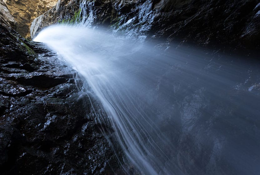
At the falls, many hikers opt to wade across Zapata creek to gain the best views and experience of the waterfall. Zapata Falls is unusual as it is tucked back in a short tunnel in the rock where the water funnels 30 feet down from the creek high above. Though a small creek, after heavy rains, the current can become very strong. Exercise great care on the slippery rock, and be sure to bring your water shoes if you opt to explore the base of the falls.
Zapata Falls is accessible in the winter when it turns into a frozen masterpiece of ice and snow.
Camping Near Zapata Falls
It's quite a drive to hike Zapata Falls, and you may want to do more than just hike. Camping is an option! There is a USFS campground next to the Zapata Falls Trailhead. It's a popular spot with 23 sites, all non-reservable. On weekends these campsites fill up by Friday at noon. On holiday weekends, they are at capacity before Friday. For fees and more details, see the official USFS campground page for Zapata Campground.
Tips & Resources for Hiking to Zapata Falls
- Pathfinder: We would like to thank, Dayhikes Pathfinder, Patrick Mitchell for hiking this trail, providing a report, and photos of his hike to Zapata Falls.
- Oasis General Store: This place is the only store for miles and just outside the National Park off of Highway 150 North.
- Packing List: Always pack the 10 Essentials. Download our Hiking Guide to get list and dayhiking packing checklist.
- Colorado Road Conditions: Colorado Road Conditions
- Photo: We would like to express our gratitude to Ben Flasher for sharing such an amazing photograph of Zapata Falls.
- After the Hike: The Roast Cafe in Alamosa, CO
Weather
Map & Driving Directions
Click for Driving Directions
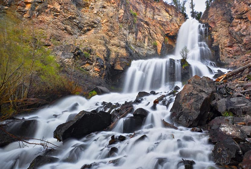
Treasure Falls Near Pagosa Springs Colorado
Treasure Falls is a 105 foot, plunge waterfall just 15 miles outside of Pagosa Springs, Colorado. It's just a 1/2 mile hike in to the falls where you can get close enough to feel the spray and mist from the falling water. It's a sight that kids and adults alike will remember. Explore the full Treasure Falls hike profile below for trail map, driving directions, and more of the details you need to enjoy this adventure near Wolf Creek Pass in Colorado.
Trail Snapshot: Treasure Falls Near Pagosa Springs, Colorado
| Hike Distance | 1 mile Round Trip |
|---|---|
| Difficulty | Easy |
| Duration | Approx 30 min Round Trip |
| Trail Type | Out and Back |
| Starting Elevation | 8275′ |
| Elevation Gain | +200′ |
| Seasons | Year Round (possible winter closings) |
| Dogs | Allowed On Leash |
| Denver Drive Time | 4 hr 45 min |
| Driving Directions to Treasure Falls near Pagosa Springs, CO | Click for Google Map |
| Town Nearest Hike | Pagosa Springs, Colorado |
| Beauty | Waterfall, Scenic Drive area, Fall Creek |
| Activities | Hiking, Photography |
Parking & Trailhead Information for Treasure Falls in Colorado
Treasure Falls is located about 15 miles northeast of the town of Pagosa Springs, along highway 160 near Wolf Creek Pass. Driving from Pagosa Springs, the parking area and trailhead for Treasure Falls are located on the right (east) side of the road. Parking can accommodate about 18 vehicle and 3 RV/trailers. There are restrooms at the site. Because parking is limited, it fills to capacity often during the summer months. Though the trailhead is open year round, sometimes the entrance gets blocked by plowed snow. Some have noted Treasure Falls as a handicap accessible hike, but it is not. However, the waterfall can be viewed--at a distance--from the parking area.
The Hike: Treasure Falls in Colorado
Treasure Falls is a 105 foot plunge waterfall with a horsetail spray. This hike is approximately 1/2 mile to the two different observations decks. The complete journey down to the falls and back (includes both observation decks) is a total of 1 mile. Along the way, hikers learn the history of the area and the story of how Treasure Falls got its name: a legend that a treasure was buried near the sight. Kids (adults, too) will love this short hiking trail, the history, and the captivating site of one of Colorado's highest waterfalls. While short, the hike is steep, and older folks and those who have difficulty walking, may find the journey beyond their ability.
The first observation deck, named Blowout, takes the trail to the right. The second observation deck, which is closer to the waterfall--so close that you can feel the spray from the falls--is called Misty Deck, and can be reached by going back to the main trail and following the signs.
The trail to Treasure Falls is steep and can become quite muddy with the spring snowmelt and rains. In the Winter, the waterfall freezes over into an aqua stream of ice. During these months, when the parking lot is not plowed or snowed in, Treasure Falls can be accessed by snowshoeing or hiking in with traction devices or microspikes--much depends on the amount of snowfall. Ice can compound with the snow to make the trail very difficult.
Tips & Resources for Hiking to Treasure Falls, CO
- Hot Cocoa: After the trip, drive up the the Wolf Creek ski area and get hot chocolate at the lodge.
- Wear Good Footwear: The hike up to treasure falls can be slick in places, and muddy in the spring. Be sure to have durable and gripping boots or shoes. Looking for good boots? Check out our hiking boot reviews.
- Packing List: Always pack the 10 Essentials. Download our Hiking Guide to get list and dayhiking packing checklist.
- Colorado Road Conditions: Colorado Road Conditions
- After the Hike: Alley House Grill in Pagosa Springs
- Photo: We would like to express our gratitude to Tobias Haase for sharing such an amazing photograph of this hike.
Weather
Map & Driving Directions
Click for Driving Directions
Helen Hunt Falls in Colorado Springs
Helen Hunt Falls in Colorado Springs is a 35 foot waterfall requiring only a short walk from the parking area. For a longer and more demanding hike, visitors can take the 4 mile Columbine Trail from the bottom of Cheyenne Canyon to Helen Hunt Falls. This strenuous option affords and experience of the rich ecosystem of this canyon at the base of Pikes Peak. Explore the full Helen Hunt Falls hike profile below for trail map, driving directions, and many of the details you need to enjoy this waterfall in Colorado Springs.
Trail Snapshot: Helen Hunt Falls
| Hike Distance | 1/10 mile or 8 Miles Round Trip |
|---|---|
| Difficulty | Easy to Moderate |
| Duration | Approx 10 min or 4 hrs |
| Trail Type | Out and Back |
| Starting Elevation | 7200′ |
| Elevation Gain | Negligible or Approx 1000'+ |
| Seasons | Year Round |
| Dogs | Allowed On Leash |
| Hike Trail Map | Click for a Map of North Cheyenne Canyon Area |
| Denver Drive Time | 1 hr 45 min |
| Driving Directions to Helen Hunt Falls, Colorado Springs | Click for Google Map |
| Town Nearest Hike | Colorado Springs, Colorado |
| Beauty | Waterfalls, Cheyenne Canyon, North Cheyenne Creek |
| Activities | Hiking, Picnicking, Mountain Biking, Photography |
Parking & Trailhead Information for Helen Hunt Falls
Helen Hunt Falls is located in the upper reaches of North Cheyenne Canyon in Colorado Springs. The driving directions and map in the trail snapshot (above) direct hikers to the small parking area nearest to the waterfall. However, this lot is often full, so visitors will need to drive further up into the canyon to additional parking. The Helen Hunt Falls area is a trailhead to several hikes in the canyon, so the parking areas do fill quickly on weekends and during the busy vacation season. Go early to park close. In case you or a friend are unable to make the short hike to the falls, they are visible along the road from your vehicle. Drive with care through the canyon as there are many cyclists on this stretch of road.
The longer hike begins near the Strasmore Visitor Center at the entrance to Cheyenne Canyon. Click for Driving Directions.
The Hike: Helen Hunt Falls
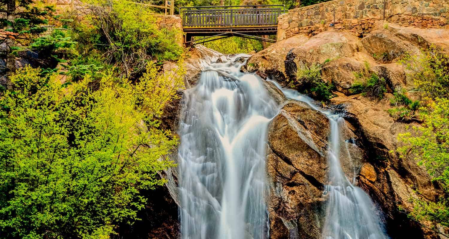
Helen Hunt Falls is a 35 foot waterfall that cascades over the rock in North Cheyenne Creek. The falls are most beautiful when Cheyenne Canyon's water volume is at it's peak in the late Spring to early Summer, or after a good rain. It's not much of a hike to Helen Hunt Falls because the base of the falls can be accessed just a few steps from the Helen Hunt Falls Visitor Center. The visitor center is open only in the Summer and has snacks and gifts for sale. The waterfall access is open year-round and there is no fee.
In the winter, the frozen falls have a beauty of their own, but be advised that the trails can be very slick and icy.
There is short, but more strenuous trail just after the bridge and to the left. The trail has a set of stairs built into the side of the canyon that lead to an overlook and another perspective on the waterfall.
If you prefer a longer, creekside hike to the Falls, then park at the Strasmore Visitor Center at the entrance to the Canyon. Near the visitor center, you can locate the Lower Columbine Trailhead. This creekside trail weaves through Cheyenne Canyon all the way up to Helen Hunt Falls. It's 4 miles one-way to the Upper Columbine Trailhead near the falls, and about 1000+ feet of elevation gain. Because the trail follows the creek and over a lot of rocky surface, be prepared for slick surfaces, and be sure to wear a solid pair of hiking boots. Trekking poles will be exceptionally helpful on this stretch of trail. About midway up the Columbine Trail, it abandons the creek, crosses the road, and begins a significant climb that includes a set of demanding switchbacks. Eventually, the trail nears Tunnel #2 along Gold Camp Road, then terminates at the Helen Hunt Falls area.
Helen Hunt Falls is named for reformer, activist, and writer, Helen Hunt Jackson, who fought for Native American Rights in the era of Reconstruction after the Civil War.
Tips & Resources for Hiking Helen Hunt Falls
- Explore More: Hike further to Silver Cascade Falls to take in a second waterfall. It's less than 1/2 mile from Helen Hunt Falls with an elevation gain of approximately 250 feet.
- Pack a Picnic Lunch: Helen Hunt Falls and Cheyenne Creek are great places to enjoy a picnic lunch.
- Bear and Mtn Lion Activity: Like many areas along the Front Range of Colorado, Bear and Mtn. Lions live in Cheyenne Canyon and the surrounding countryside. Dispose of food in the proper containers. Be alert. And keep together as a group. It's best that children don't run ahead, but stay with your group. Dogs should be leashed at all times.
- Trail Map for North Cheyenne Canyon: Trail Map Link
- Packing List: Always pack the 10 Essentials. Download our Hiking Guide to get list and dayhiking packing checklist.
- Colorado Road Conditions: Colorado Road Conditions
- After the Hike: Urban Steam Coffee
- Photo: We would like to express our gratitude to Mike Sinko for sharing such an amazing photograph of this hike.
Weather
Map & Driving Directions
Click for Driving Directions

Rifle Falls Hike Colorado
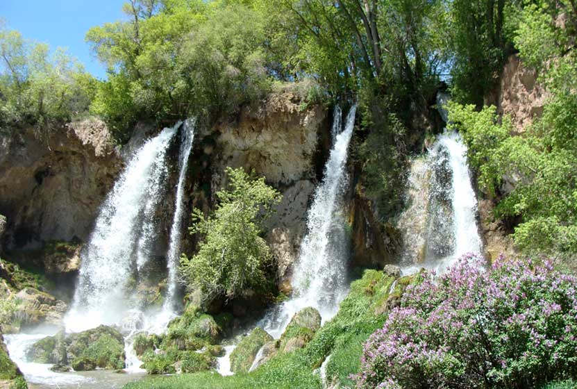
Rifle Falls is a 70 foot, triple waterfall in Rifle Falls State Park. It's just .1 mile hike to the base of the falls along a paved, handicap accessible trail. The caves hidden along the waterfall beckon those looking for more adventure. Explore the full Rifle Falls hike profile below for trail map, driving directions, and more of the details you need for this short waterfall Hike in northwestern Colorado.
Trail Snapshot: Rifle Falls Colorado
| Hike Distance | 0.2 to 1.5 mile Round Trip |
|---|---|
| Difficulty | Easy |
| Duration | 30 minutes |
| Trail Type | Out & Back or Loop |
| Starting Elevation | 6500′ |
| Elevation Gain | Negligible to +100' |
| Seasons | Year Round |
| Dogs | Allowed On Leash |
| Hike Trail Map | Click for a Map of Rifle Falls State Park, Colorado |
| Denver Drive Time | 3 hr 30 min |
| Driving Directions to Rifle Falls | Click for Google Map |
| Town Nearest Hike | Rifle, Colorado |
| Beauty | Waterfall, Caves, Rifle Creek |
| Activities | Hiking, great picnic facilities, caves, fishing, photography |
| Fee | See the Rifle Falls Fees Page |
Parking & Trailhead Information for Rifle Falls, Colorado
Because Rifle Falls State Park is one of the more popular State parks to visit in Colorado, it often has very limited parking. We highly recommend that you arrive when the park opens at 7AM. If you do not have a Colorado State Parks pass, then you will need to pay the access fee for the park at the kiosk. If the lot is full, visitors will be turned away. As with almost all trailheads in Colorado, Monday through Thursday are the best days for avoiding traffic. However, in the busy summer season, when the weather is amazing and vacation season is in full swing, the park is often at capacity.
The Hike: Rifle Falls
The base of the waterfall can be accessed via 1/10th mile hike on a paved trail that is considered ADA accessible. The falls launch 70 feet over a limestone cliffside, reminiscent of Hanging Lake, near Glenwood Springs. It is a segmented waterfall, breaking into three distinct waterfalls. The spray and mist from the falls makes the surrounding scenery unique. Moss covered rock, flowers, brush, trees, and the roar of the falls make this a real oasis in the oft dry landscape of western Colorado.
The Coyote Trail crosses the creek and leads hikers on a 1.5 mile loop that includes both caves and the area above the waterfall. Following the loop counter-clockwise, the caves will soon become visible on the left-hand side of the trail. After the caves, the loop continues back towards the top of the waterfall area and crosses the creek before making its way back to the shaded picnic grove and parking area.
Rifle Falls in Winter
Rifle Falls State Park is open all year round. It's Colorado, so expect snow and ice on the trail in the late Autumn through late Spring.
Camping at Rifle Falls
There are 20 camping spots at Rifle Falls State Park. Thirteen are drive-in camping and seven are walk-in sites. All are along Rifle Creek. A number of the sites are reservable from May 1 to Oct. 31, and others are available on a first-come basis. Weekdays have better availability than weekends, and the campsites are in less demand November through April. Because Rifle Falls State Park is open year-round, camping is available year-round as well. Pets are allowed, but must be kept on a 6' leash.
Weddings at Rifle Falls
The Waterfall is also a popular place to tie the knot. The Mountain Mist Amphitheater is reservable and has a capacity of 50. All arrangements must be made ahead of time with the parks office (970) 625-1607. All vehicles must pay the fee or have a Colorado State Parks Pass. Because of the limited parking, those coming for a wedding should plan to car pool or be dropped off at the park.
Tips & Resources for Hiking at Rifle Falls State Park
- Go Early: Rifle Falls State Park is small and very popular. The park opens at 7AM, and we recommend that you arrive early for parking.
- Bring a Flashlight or Headlamp: If you plan to explore the caves, you'll need a light. Bring a flashlight or headlamp to light up some of the chambers you'll discover in the caves.
- Trail Map for Rifle Falls State Park: Trail Map Link
- Packing List: Always pack the 10 Essentials. Download our Hiking Guide to get list and dayhiking packing checklist.
- Colorado Road Conditions: Colorado Road Conditions
- After the Hike: Oliver Ridleys Coffee
- Photo: We would like to express our gratitude to Jimmy Thomas for sharing such an amazing photograph of this hike.
Weather
Map & Driving Directions
Click for Driving Directions

Fish Creek Falls Near Steamboat Colorado
A 284 foot waterfall! Need we say more. Fish Creek Falls is a 1/4 mile hike located just outside Steamboat Springs, Colorado--about 3.5 hours from Denver. The Fish Creek Falls Overlook trail is handicap accessible, and a second trail takes hikers down to the base of the falls. Explore the full Fish Creek Falls hike profile below for trail map, driving directions, and many the details you need to enjoy this adventure near Steamboat, Colorado.
Trail Snapshot: Fish Creek Falls in Steamboat Springs
| Hike Distance | 1/2 mile Round Trip (both options) |
|---|---|
| Difficulty | Easy |
| Duration | Approx 30 min Round Trip |
| Trail Type | Out and Back |
| Starting Elevation | 7500′ |
| Elevation Gain | negligible |
| Seasons | Year Round |
| Dogs | Allowed On Leash |
| Denver Drive Time | 3 hrs |
| Driving Directions to Fish Creek Falls, Steamboat Springs | Click for Google Map |
| Town Nearest Hike | Steamboat Springs, Colorado |
| Beauty | Waterfalls, Creek |
| Activities | Hiking, great picnic facilities, ice climbing, photography |
| Hours | 6AM to 10AM |
| Fee | $5 Day Use Fee - Cash or Check |
Parking & Trailhead Information for Fish Creek Falls
The trailhead for the waterfall is about three miles outside of the town of Steamboat Springs, Colorado. Stop at the pay station to purchase the day use fee. There are two parking areas: one will be on your left driving in, and the larger lot--which is closer to the trailhead--at the end of the road.
The Hike: Fish Creek Falls
Fish Creek Falls is one of the most accessible waterfalls in Colorado, perfect for families with small children who are not yet able to hike longer distances. It's also wheelchair accessible via the Falls Overlook Trail. There are three different options detailed below.
-
Fish Creek Falls Overlook Hike:
This 1/4 mile (one-way) hike leads to the Falls overlook. The trail is paved and handicap accessible. The most direct access to the overlook trail is from the northeast end of the larger parking area, near the interpretive signs and the small shelter.
-
Fish Creek Falls Hike:
This second option is also a 1/4 mile (one-way) and leads to the bridge at the base of the falls. The trail is gravel and dirt--not paved like the overlook trail. This trail begins at the far east end of the same parking lot.
-
1 Mile Loop:
Both the overlook and the Fish Creek Falls hikes can be combined to form a kind of 1 mile loop by hiking first to the overlook, then returning through the shaded picnic area to the Fish Creek trail below. After hiking to the bridge, return the way you came.
Tips & Resources for Hiking Fish Creek Falls
- Bring a Picnic Lunch: The picnic area at Fish Creek Falls is one of the best in the State of Colorado. It's extensive and the trees provide a ton of shade.
- Springtime is Best: The waterfall roars with the late Spring meltwater.
- In Winter: The trails to the falls are open year round. You may need snowshoes when the snow gets thick.
- Explore More: There is another waterfall. A short, but demanding, 2.2 mile (one-way) hike to Upper Fish Creek falls follows the trail beyond the bridge and another 1,100+ feet above the trailhead.
- Packing List: Always pack the 10 Essentials. Download our Hiking Guide to get list and dayhiking packing checklist.
- Colorado Road Conditions: Colorado Road Conditions
- After the Hike: Creekside Cafe in Steamboat Springs
- Photo: We would like to express our gratitude to Greg Hamilton for sharing the photograph of this hike.
Weather
Map & Driving Directions
Click for Driving Directions
Silver Falls Near Pagosa Springs Colorado
Silver Falls near Pagosa Springs Colorado is an easy hike of less than a quarter mile to a spectacular waterfall. The distance of the drive from Denver requires more than the hike! Explore the full Silver Falls hike profile for driving directions and all the details you need to enjoy this Colorado waterfall trail.
Trail Snapshot: Silver Falls Near Pagosa Springs, Colorado
| Hike Distance | 0.4 mile Round Trip |
|---|---|
| Difficulty | Easy to Moderate |
| Duration | Approx 30 min |
| Trail Type | Out and Back |
| Starting Elevation | 8200′ |
| Elevation Gain | Approx +230′ |
| Seasons | May-September |
| Dogs | Allowed On Leash |
| Denver Drive Time | 5.5 hr |
| Driving Directions to Silver Falls, Pagosa Springs | Click for Google Map |
| Town Nearest Hike | Pagosa Springs, Colorado |
| Beauty | Waterfall |
| Activities | Hiking |
Directions & Trailhead Information for Silver Falls
The parking area for Silver Falls is located about 19 miles from Pagosa Springs along Forest Road 667. Because FR667 is a dirt road, expect washboard and wash areas. The road crosses multiple creeks, and in the late Spring, when the snowmelt is flowing, many of these creeks rise and cover the road. Because of this, it's a good idea to make the drive to the Silver Falls trailhead in a vehicle with higher clearance, such as a truck or SUV. The small parking area is located about 8 miles up 667 on the left-hand side of the road. You'll find an old guard station marking the spot.
The Hike to Silver Falls
The hike up to Silver Falls is short and sweet. It's approximately 1/8th of a mile from the trailhead to the waterfall. The trail starts out easy, then becomes increasingly steep before the emerging from the woods to the spectacular site of Silver Falls. The waterfall plunges first from the orange cliffs above the trail, then tumbles down in a series of dazzling cascades.
Tips & Resources for Hiking Silver Falls, Pagosa Springs, CO
- Visit on a Weekday: This stretch of road is a popular spot for campers and fisherman because of its proximity to the San Juan River. Go on a weekday if you would like to experience solitude and only the sounds of tumbling water.
- Parking: Parking is limited in the small lot. Hikers can also park alongside the road; just be courteous to other drivers and be sure to park in such a way that you don't to get stuck.
- Packing List: Though it's a short hike, you always want to pack the 10 Essentials. Download our Hiking Guide to get list and hiking gear checklist.
- Colorado Road Conditions: Colorado Road Conditions
- Photo: We would like to express our gratitude to Steve Schmickle of Explore the Light Photography for sharing such an amazing photograph of this hike to Silver Falls. I love landscape photography, and Steve's work is my absolute favorite. Check out his gallery and available prints.
- After the Hike: Pagosa Baking Company in Pagosa Springs
Weather
Map & Driving Directions
Click for Driving Directions
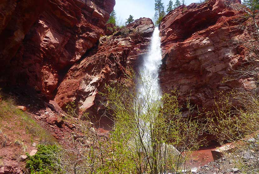
Cornet Falls Near Telluride Colorado
Cornet Falls in Telluride, Colorado, is an 80 foot waterfall and requires a short 1/4 mile hike to experience. The hike begins in town and affords views down into this beautiful Colorado mountain town. Explore the full Cornet Falls hike profile below for trail map, driving directions, and all the details you need to enjoy this hike in Telluride, CO.
Trail Snapshot: Cornet Falls Near Telluride, Colorado
| Hike Distance | 1/2 mile Round Trip |
|---|---|
| Difficulty | Easy |
| Duration | Approx 30 min |
| Trail Type | Out and Back |
| Starting Elevation | 8900′ |
| Elevation Gain | +220′ |
| Seasons | May-September |
| Dogs | Allowed On Leash |
| Hike Trail Map | Click for a Map of Telluride Area Trails |
| Denver Drive Time | 6.5 hrs |
| Driving Directions to Cornet Falls, Telluride | Click for Google Map |
| Town Nearest Hike | Telluride, Colorado |
| Beauty | Waterfalls, Views into Town of Telluride |
| Activities | Hiking |
Parking & Trailhead Information for Cornet Falls
The hike to Cornet Falls begins at the the Jud Weibe Trailhead in Telluride, Colorado. There is no designated parking area for this trailhead, so hikers will need to find acceptable parking along the streets or at public parking in town.
Tips & Resources for Hiking Cornet Falls Colorado
The hike from the Jud Weibe Trailhead to Cornet Falls is only a 1/4 mile. The trail makes its way through a lot of loose and slippery rock before it opens out to a backdrop of vermillion cliffs with 80 foot Cornet Falls jetting over the side. Stay to the right side of the creek for the proper trail leading to the waterfall.
- Wear Good Footwear: Because of the loose rock and slippery surfaces, be sure to wear a durable pair of shoes or boots that will give you good traction for this hike. Need a new pair of boots? Then be sure to check out our boot review of 3 recommended hiking boots.
- Explore More: For a longer adventure, hikers can stay on the Jud Wiebe trail and complete the 3 mile loop that features expansive views into the town of Telluride and ovf Bridal Veil Falls in the distance.
- Trail Map for Telluride Area: Trail Map Link
- Packing List: Always pack the 10 Essentials. Download our Hiking Guide to get list and dayhiking packing checklist.
- Colorado Road Conditions: Colorado Road Conditions
- After the Hike: Between the Covers Bookstore & Espresso Bar
- Photo: We would like to express our gratitude to Dan Wilnai for sharing such an amazing photograph of this hike to Cornet Falls.
Weather
Map & Driving Directions
Click for Driving Directions
Looking for more waterfalls near Denver? Explore our more than 50 Colorado Waterfall Hikes, our favorite Waterfall Hikes in Rocky Mountain National Park, or 7 Waterfalls within One Hour of Denver.
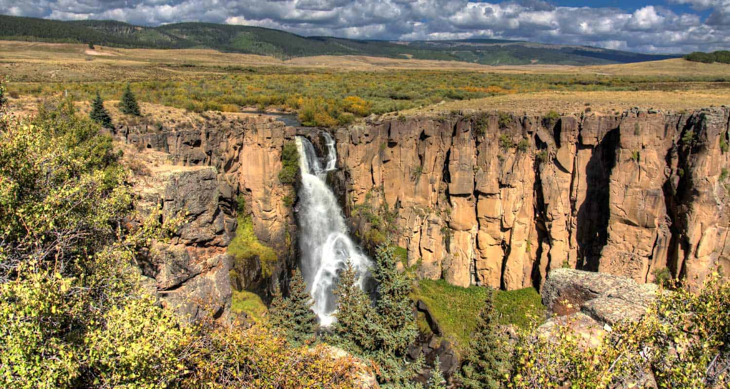
North Clear Creek Falls in Colorado
North Clear Creek Falls is a 100+ foot waterfall carved into the landscape of southwestern Colorado. This is not so much a hike as a great place to pull off for a picnic and take in views of what become the most famous waterfall in the Rocky Mountain State. Explore the full North Clear Creek Falls profile below for driving directions, and all the details you need to experience this scenic landmark in the far reaches of Colorado.
Trail Snapshot: North Clear Creek Falls Near Lake City, Colorado
| Hike Distance | 0.1 mile Round Trip |
|---|---|
| Difficulty | Easy |
| Duration | Approx 5 min |
| Trail Type | Pull-off Observation Area |
| Starting Elevation | 10,000′ |
| Elevation Gain | +0′ |
| Seasons | June to September |
| Dogs | Allowed On Leash |
| Denver Drive Time | 5 hrs |
| Driving Directions to North Clear Creek Falls | Click for Google Map |
| Town Nearest Hike | Lake City, Colorado |
| Beauty | Waterfall Observation area |
| Activities | picnic facilities, photography |
Its hard to believe that what may be the most beautiful waterfall in Colorado requires no hike to see. The North Clear Creek Falls observation area is accessible via a short drive off of Forest Road 510, part of the Silver Thread Scenic Byway. The USFS does not plow this section during the winter, so it may be inaccessible until Spring. Because of the vertical drop into Willow Canyon, the observation area has been fenced. The area has new toilet and picnic facilities, and is considered handicap accessible.
Tips & Resources for North Clear Creek Falls
- TIP: Because North Clear Creek Falls faces east, some of the best time for photography will be in the early morning moments as the sun is rising.
- TIP: Bring a picnic lunch. The observation area near the falls has new picnic facilities.
- Packing List: Always pack the 10 Essentials. Download our Hiking Guide to get list and dayhiking packing checklist.
- Colorado Road Conditions: Colorado Road Conditions
- After the Hike: Tommyknocker Tavern in Creede
- Photo: We would like to express our gratitude to Scott Ingram for sharing such an amazing photograph of this hike.
Weather
Map & Driving Directions
Click for Driving Directions
Adams Falls in Rocky Mountain National Park
Adams Falls is a short .6-mile round-trip hike near Grand Lake, Colorado. The waterfall borders Rocky Mountain National Park and its trail begins at the same trailhead for the East Inlet Trail. Explore the full Adams Falls hike profile below for trail map, driving directions, and all the details you need for this short waterfall Hike in Rocky Mountain National Park.
Note: Rocky Mountain National Park now requires timed entry permits from May 27th through October 10th. See the RMNP permits page for more information.
Trail Snapshot: Adams Falls in Rocky Mountain National Park
| Hike Distance | 0.6 mile Round Trip |
|---|---|
| Difficulty | Easy |
| Duration | Approx 30 min Round Trip |
| Trail Type | Out and Back |
| Starting Elevation | 8400' |
| Elevation Gain | +79' |
| Seasons | May-September |
| Dogs | Prohibited in Rocky Mountain National Park |
| Hike Trail Map | Click for a Trail Map |
| Denver Drive Time | 2 hr 15 min |
| Driving Directions to Adams Falls, Colorado | Click for Google Map |
| Town Nearest Hike | Grand Lake, Colorado |
| Beauty | Waterfall, East Inlet Creek |
| Activities | Hiking, picnicking, photography |
Adams Falls is named after Jay E. Adams, an early settler of Grand Lake, Colorado. This hike is on the quieter western side of Rocky Mountain National Park. However, it's still a popular trail, so expect to encounter a lot of hikers. Go on a weekday or early morning for the experience of quiet and solitude. After hiking the .3 mile segment of trail, you'll arrive at Adams Falls. There is an observation area that grants the best and safest views of the falls.
The hike to Adams Falls is perfect for families with young children who may not be able to hike as far. As with all streams and waterfalls, have children exercise caution and stay away from the streambank. Rocks are slippery and the hydraulic force of the creek can be incredibly powerful. About 1/4 mile beyond Adams Falls, there are spectacular views of the East Meadows, making the short distance a worth addition to this easy waterfall hike.
Tips & Resources for Hiking to Adams Falls, Grand Lake, CO
- Wear Good Footwear: The trail has a lot of rocks and roots, so be sure to have shoes or boots that can handle slick surfaces.
- Explore More: Hike about a quarter mile past the falls to where the meadows open up and East Inlet creek meanders through the tall grass. It's an amazing sight.
- Trail Map for Rocky Mountain National Park: Trail Map
- Packing List: Always pack the 10 Essentials. Download our Hiking Guide to get list and dayhiking packing checklist.
- Colorado Road Conditions: Colorado Road Conditions
- After the Hike: The Hub Coffee
- Photo: We would like to express our gratitude to Kimon Berlin for sharing such an amazing photograph of this hike.
Weather
Map & Driving Directions
Click for Driving Directions